 Metadata catalogue
WP6 Dynamics of ecosystem state and resources
Type of resources
Available actions
Topics
INSPIRE themes
Keywords
Contact for the resource
Provided by
Years
Formats
Representation types
status
Resolution
-
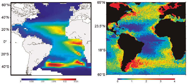
SEAPODYM has been initiated in the mid-1990s by the Oceanic Fisheries Programme of the Secretariat of the Pacific Community (SPC) and developed under several European development projects. The objective was to propose new management tools taking into account both the fishing impact and environmental variability. Since 2006, in partnership with SPC, its development has continued with the Marine Ecosystem Modeling team of CLS (Collecte Localisation Satellite). CLS aims to combine this modeling approach with satellite observation and real-time data collection to develop operational real-time applications and advise government administrations on the sustainable management and monitoring of marine resources. The main features of SEAPODYM framework are: - Prediction of the temporal and spatial distributions of functional lower and mid-trophic level groups (Lehodey et al. 2010; 2015) - Prediction of the temporal and spatial distributions of age-structured predator (fish) populations (Lehodey et al. 2008); - Prediction of the total catch and the size-frequency of catch by fishing fleet; - Parameter optimization based on data assimilation techniques (Senina et al., 2008); The lower and mid-trophic level (LMTL) sub-model describes the dynamics of a functional group of zooplankton and several vertically migrant and non-migrant micronekton (prey of larger fish) groups. The dynamics are linked to temperature and currents. Assimilation of acoustic or biomass data is used to estimate the model parameters. The dynamics of fish populations are estimated using habitat indices, movements, growth and mortality. The feeding habitat is based on the accessibility of fish to the groups of prey. The spawning habitat combines temperature preference and coincidence of spawning with presence or absence of predators and food for larvae. Successful larval recruitment is linked to spawning stock biomass and mortality during the drift with currents. Older fish can swim along the gradient of habitat index in addition to being advected by ocean currents.
-
The GEBCO grid is global data set of elevation values, in metres, on a 15 arc-second interval grid. It is accompanied by a Type Identifier (TID) Grid that gives information on the types of source data that the GEBCO_2024 Grid is based on. An additional 4.34 million square kilometres of bathymetric data has been added to the global grid since the last release in 2023, with 26.1% of the seabed now mapped. This is the Sixth GEBCO grid developed through the Nippon Foundation-GEBCO Seabed 2030 Project.This is a collaborative project between the Nippon Foundation of Japan and GEBCO. The aim of the project is to map the global sea floor by 2030. GEBCO's grids can be downloaded as a global file in netCDF format or for user-defined areas, through our download app, in netCDF, data GeoTiff and ESRI ASCII raster formats. The data set can also be downloaded in the form of imagery. This release of the GEBCO grid includes data from version 5.0 of the International Bathymetric Chart of the Arctic Ocean (IBCAO) . GEBCO's aim is to provide the most authoritative publicly-available bathymetry of the world's oceans. It operates under the joint auspices of the International Hydrographic Organization (IHO) and the Intergovernmental Oceanographic Commission (IOC) (of UNESCO).
-
The GEBCO_2022 Grid is a global continuous terrain model for ocean and land with a spatial resolution of 15 arc seconds. In regions outside of the Arctic Ocean area, the grid uses as a base Version 2.4 of the SRTM15_plus data set (Tozer, B. et al, 2019). This data set is a fusion of land topography with measured and estimated seafloor topography. Included on top of this base grid are gridded bathymetric data sets developed by the four Regional Centers of The Nippon Foundation-GEBCO Seabed 2030 Project. The GEBCO_2022 Grid represents all data within the 2022 compilation. The compilation of the GEBCO_2022 Grid was carried out at the Seabed 2030 Global Center, hosted at the National Oceanography Centre, UK, with the aim of producing a seamless global terrain model. Outside of Polar regions, the Regional Centers provide their data sets as sparse grids i.e. only grid cells that contain data are populated. These data sets were included on to the base using a remove-restore blending procedure. This is a two-stage process of computing the difference between the new data and the base grid and then gridding the difference and adding the difference back to the existing base grid. The aim is to achieve a smooth transition between the new and base data sets with the minimum of perturbation of the existing base data set. The data sets supplied in the form of complete grids (primarily areas north of 60N and south of 50S) were included using feather blending techniques from GlobalMapper software. The GEBCO_2022 Grid has been developed through the Nippon Foundation-GEBCO Seabed 2030 Project. This is a collaborative project between the Nippon Foundation of Japan and the General Bathymetric Chart of the Oceans (GEBCO). It aims to bring together all available bathymetric data to produce the definitive map of the world ocean floor by 2030 and make it available to all. Funded by the Nippon Foundation, the four Seabed 2030 Regional Centers include the Southern Ocean - hosted at the Alfred Wegener Institute, Germany; South and West Pacific Ocean - hosted at the National Institute of Water and Atmospheric Research, New Zealand; Atlantic and Indian Oceans - hosted at the Lamont-Doherty Earth Observatory, Columbia University, USA; Arctic and North Pacific Oceans - hosted at Stockholm University, Sweden and the Center for Coastal and Ocean Mapping at the University of New Hampshire, USA.
-
The GEBCO_2021 Grid is a global continuous terrain model for ocean and land with a spatial resolution of 15 arc seconds. This is the third GEBCO grid produced through the framework of the Nippon Foundation-GEBCO Seabed 2030 Project. The aim of the project is to map the global sea floor by 2030. For the 2021 release of the GEBCO grid, it is estimated that 20.6% of seafloor has now been mapped, this is an increase from 19% for the previous release, GEBCO_2020. The GEBCO_2021 Grid uses as a ‘base’ Version 2.2 of the SRTM15+ data set between latitudes of 50° South and 60° North. This data set is a fusion of land topography with measured and estimated seafloor topography. The base grid has been augmented with the gridded bathymetric data sets developed by the four Seabed 2030 Regional Centers to produce the global GEBCO grid. The primary GEBCO_2021 grid contains land and ice surface elevation information - as provided for previous GEBCO grid releases. In addition, for the 2021 release, we have made available a version with under-ice topography/bathymetry information for Greenland and Antarctica. GEBCO's aim is to provide the most authoritative publicly-available bathymetry of the world's oceans. It operates under the joint auspices of the International Hydrographic Organization (IHO) and the Intergovernmental Oceanographic Commission (IOC) (of UNESCO).
-
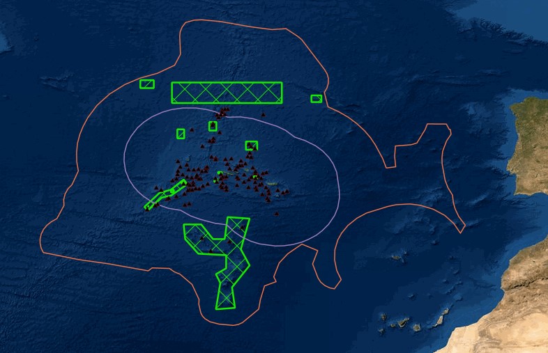
Portal of Maritime Spatial Planning of the Azores which hosts several GIS layers, such as: - Fishing areas and aquaculture production areas - Bathymetry - Mineral resources: Deep seabed polymetallic nodules - Hydrothermal vents - Distribution of seamount extracted, 2008 - Seafloor geomorphologic classification - Ocean environmental variables mean between the years 2002 and 2013: Sea Surface Temperature, Chlorophyll-a Concentration, Particulate Organic Carbon and Particulate Inorganic Carbon, Photosynthetically, Available Radiation, Ocean Productivity - Maerl habitats - Predictive distribution modelling for 26 cold-water coral species - Coldwater corals - Legal issues - Infrastructure and equipment - Underwater cultural heritage - Aggregate extraction - Tourist maritime activities