 Metadata catalogue
WP3 Pelagic Mapping
Type of resources
Available actions
Topics
INSPIRE themes
Keywords
Contact for the resource
Provided by
Years
Formats
Representation types
Update frequencies
status
Resolution
-
Quonops Online Services provide noise monitoring and prediction tools. In a similar manner to weather forecasting systems, Quonops© produces an estimate of the spatio-temporal distribution of noise levels generated by human activities at sea, aggregating multiple sources, and assessing short-, mid- and long-term source contributions to the global noise field. The outputs from Quonops© are tailored to the requirements of existing and emerging national and international regulations regarding: - Underwater noise. - The conservation of habitats and marine ecosystems. - The protection of marine species. Such tools aim to support management decisions by assessing, quantifying and prioritizing direct and indirect anthropogenic pressures on marine life, according to regulations on underwater noise, especially the descriptor 11 of the European Marine Strategy Framework Directive.
-
Maritime Spatial Planning (MSP) is globally recognised as a crucial tool for managing human uses and activities in maritime space, with the aim of supporting sustainable growth and development in the maritime sector and conscious use of marine and coastal resources. MSP identifies where and when human uses and activities take place in maritime space today and may take place in the future. GeoPortal SIGMAR offers a view of the maritime space of the Azores and its uses.
-
%20Raw%20Echosounder%20data.jpg)
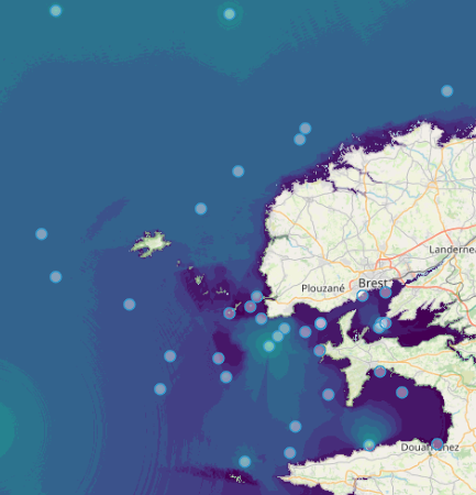
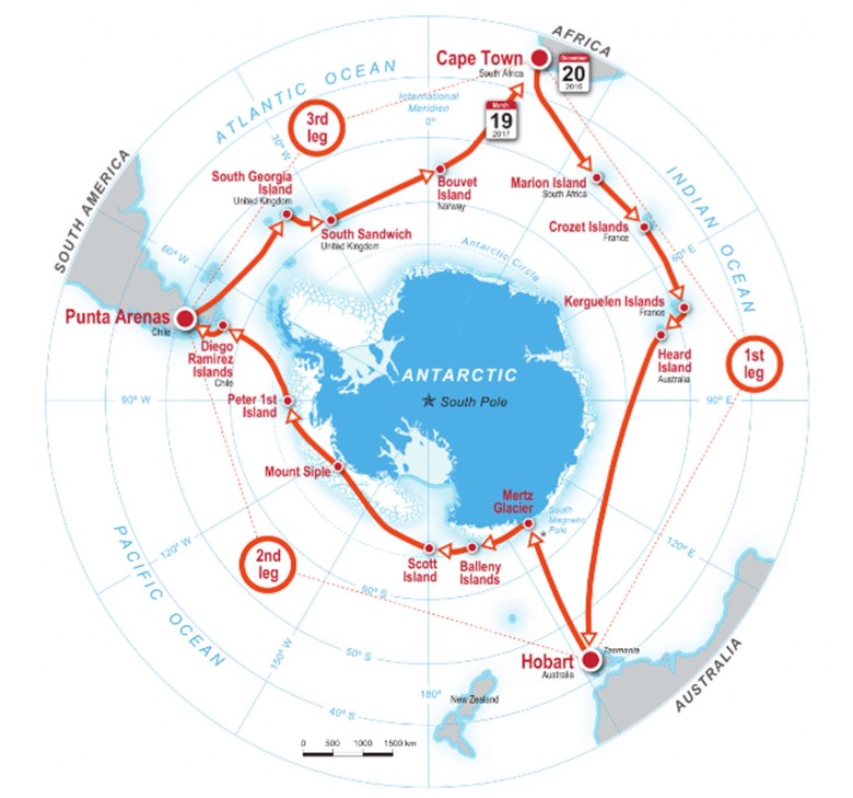
AMT25: The overall aim of the Atlantic Meridional Transect programme is: to quantify key biogeochemical and ecosystem processes and their inherent variability over extended time and spatial scales in the Atlantic Ocean. This is achieved by executing an annually repeated meridional transect through contrasting oceanic provinces, ranging from oligotrophic deserts, to highly productive shelf seas. Specific objectives: - To quantify the nature and causes of ecological and biogeochemical variability in planktonic ecosystems; - To quantify the effects of this variability on nutrient cycling, on biogenic export and on air-sea exchange of climate active gases; - To construct multi-decadal, multidisciplinary ocean time-series which are integrated within a wider "Pole-to-pole" observatory concept; - To provide essential sea-truth validation for current and next generation satellite missions; - To provide essential data for global ecosystem model development and validation; - To provide a valuable, highly sought after and unique training arena for the next generation of UK and international oceanographers. JR864: The oceanographic research ship RRS James Clark Ross attempted to physically and biologically characterise Ascension Island's shelf from 14th-18th October 2015. Multibeam sonar swath was used to generate the first open-access, high resolution mapping of Ascension Island's seabed between 100-1100m depth. These data was used to determine seabed profile and rugosity characteristics. Seabed substratum was investigated using a benthic camera lander (SUCS) and water column physico-chemistry was gained using CTD. The SUCS provided 500 photographs and video clips of benthos from 21 site/depth combinations, which showed a wide disparity in richness and density of biodiversity. These were ground-truthed by targeted Agassiz trawl samples to collect vouchers specimens for morphological and genetic identification. Specimens collected were photographed, fixed and then preserved in 96% ethanol for later genetic analyses. Preliminary analysis of the biodiversity captured was undertaken in the Conservation Department building, Georgetown, Ascension Island and indicated new records for the Island including first records of brachipods.
-
%20sub-facility.jpg)
The IMOS Bio-Acoustic Ship Of Opportunity (BASOOP) sub-facility is part of a major international effort that aims to develop a global ocean Mid-trophic Automatic Acoustic Sampler (MAAS) being proposed as part of the CLimate Impacts on Oceanic TOp Predators (CLIOTOP) program. This SOOP dataset covers the Indian Ocean and waters south and east of Australia and across to New Zealand. BASOOP commenced on the 1st of July 2010 to collect underway acoustic data while vessels are transiting ocean basins. At present, nine vessels are participating in the BASOOP program. Six are commercial fishing vessels that have agreed to record data during transits to and from fishing grounds. The remaining three are scientific research vessels collecting underway acoustic data during transits and science operations. Bio acoustic signals allow understanding how mid-water prey species (known collectively as micronekton) such as small fish, squid, krill and jellyfish are distributed. Micronekton form the core of the ocean food web, transferring energy from primary producers at the ocean surface to top predators such as tunas, billfish, sharks, seals and seabirds. The mass and distribution of micronekton reflects broad-scale patterns in the structure and function of the ocean, as well as the dynamics of marine ecosystems. The mapping complements established observing systems such as physical sampling of ocean currents, surveys of ocean chemistry and biology (plankton and zooplankton), and electronic tagging and tracking of large marine fish and mammals. The combined information greatly enhances the capacity of marine scientists to monitor shifts in food availability over time, assisting in the monitoring and modelling of oceanography, ecosystems, fisheries and climate change, and in understanding the behaviour of top predators. Data Collection: All BASOOP vessels collect 38 kHz acoustic data from either Simrad EK60, ES60 (split beam) or ES70 echosounders. In all cases the 38 kHz echosounders are connected to Simrad ES38B transducers. This is a narrow-beam (7 o) ceramic transducer with good long term stability and manufacturer supplied calibration parameters. Research vessel Southern Surveyor also collects concurrent acoustic data at 12 and 120 kHz. The research vessel Aurora Australis collects concurrent acoustic data at 12, 120 and 200 kHz. The primary data-type recorded from the vessel-mounted echosounder systems is georeferenced calibrated water column volume backscatter, Sv [dB re 1 m-1], (Maclennan et al. 2002) . The raw acoustic data is post processed to (i) identify on-transit data and prioritise processing, (ii) apply calibration offsets, (iii) apply semi-automated filters to identify and reject bad data and (iv) create output stored in netCDF format, mean echointegrated Sv for cells of 1000 m distance and 10 m height. A full metadata record is also stored in each netCDF file. Reference: *Maclennan, D.N., Fernandes, P.G., and Dalen, J. 2002. A consistent approach to definitions and symbols in fisheries acoustics. ICES Journal of Marine Science: Journal du Conseil 59(2): 365.
-
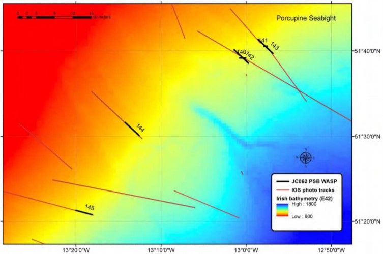
While there has been an increase in the understanding of how climate and surface processes affect deep-sea communities, the ability to understand these links further is thought to be limited by sampling error from undetected habitat heterogeneity (i.e. irregular or uneven habitat distributions). Features like hills, valleys, depressions, small rock outcrops, and biogenic mounds add to habitat complexity, but links between such features and the animals that live among them are very poorly resolved in abyssal plain habitats using current methods. Our efforts aimed to address the following objectives: 1. We serviced the PAP1, PAP3 and Bathysnap long-term observatory systems. These systems provide data that is critical in understanding connections between climate, surface ocean processes, and change in deep-sea habitats. 2. We ecologically surveyed the region around the PAP - Sustained Observatory (SO) to understand how the topography of the seabed alters the abundance and distribution of fauna in abyssal habitats. This surveying employed the use of acoustic mapping, megacoring, box coring, a baited camera lander, towed cameras, an amphipod trap, and trawling. 3. We also conducted a number of specialised research studies including research on low bandwidth observatory telecommunications, phytoplankton community structure, bioluminescence, the impacts of crude oil on benthic sediment communities, and the effects of pressure on photoreceptors, and the potential impacts of trawling on slope habitats in the Porcupine Seabight. These studies took advantage of the equipment above with the addition of conductivity temperature and depth (CTD) rosette casts and laboratory facilities. The cruise achieved its main objectives including servicing of mooring infrastructure, ecological mapping of the PAP area, and a survey of potentially impacted sponge communities on the N PSB slope. We were favoured by good weather and what proved to be mainly minor issues with winches and other equipment. We surveyed three abyssal plain areas and four hill areas within the greater vicinity of the PAP-SO. At all of these seven sites we conducted a WASP transect and at least 5 megacore deployments. At all seven survey sites except PAP Cent. we conducted a baited camera and ampipod trap deployment as the deposition of ballast at PAP Cent. was to be avoided. At the PAP Cent. site we also conducted series of five box core deployments. Details on specific activities, their objectives and initial results are provided below including ancillary activities conducted at Goban Spur and the Porcupine Seabight.
-
%20Raw%20Echosounder%20data.jpg)
The overall aim of the Atlantic Meridional Transect programme is: to quantify key biogeochemical and ecosystem processes and their inherent variability over extended time and spatial scales in the Atlantic Ocean. This is achieved by executing an annually repeated meridional transect through contrasting oceanic provinces, ranging from oligotrophic deserts, to highly productive shelf seas. The specific objectives of AMT are: - To quantify the nature and causes of ecological and biogeochemical variability in planktonic ecosystems; - To quantify the effects of this variability on nutrient cycling, on biogenic export and on air-sea exchange of climate active gases; - To construct multi-decadal, multidisciplinary ocean time-series which are integrated within a wider “Pole-to-pole” observatory concept; - To provide essential sea-truth validation for current and next generation satellite missions; - To provide essential data for global ecosystem model development and validation; - To provide a valuable, highly sought after and unique training arena for the next generation of UK and International oceanographers.
-
These data consist of raw echosounder observations collected during ACE (Leg1-Leg3) using an EK80 WBT operating at 12.5 kHz. The instrument was calibrated at South Georgia during the expedition (Leg 3) and corrections were applied prior to calculation of the volume backscattering strength (Sv). The signal-to-noise ratio (SNR) was analysed and was deemed very poor at depths greater than 1000 m. Therefore, only data collected between the transducer depth (8.4 m) and 1000 m were archived. Sv values within this depth range that had poor SNRs (<2) were deemed to be bad data and set to a value of NA. Observations were made using a pulse duration of 16.384 ms (c. 24 m) and are therefore not suitable for fine-scale studies (e.g. analysis of krill swarms). They are more suited to studies relating to large-scale biological features such as deep scattering layers.
-
%20Raw%20Echosounder%20data.jpg)
The overall aim of the Atlantic Meridional Transect programme is: to quantify key biogeochemical and ecosystem processes and their inherent variability over extended time and spatial scales in the Atlantic Ocean. This is achieved by executing an annually repeated meridional transect through contrasting oceanic provinces, ranging from oligotrophic deserts, to highly productive shelf seas. The specific objectives of AMT are: - To quantify the nature and causes of ecological and biogeochemical variability in planktonic ecosystems; - To quantify the effects of this variability on nutrient cycling, on biogenic export and on air-sea exchange of climate active gases; - To construct multi-decadal, multidisciplinary ocean time-series which are integrated within a wider "Pole-to-pole" observatory concept; - To provide essential sea-truth validation for current and next generation satellite missions; - To provide essential data for global ecosystem model development and validation; - To provide a valuable, highly sought after and unique training arena for the next generation of UK and International oceanographers.
-
.jpg)
During the JR230 cruise with RRS James Clark Ross expertise from seven countries has been pulled together to assess coupling and biodiversity from sea surface to sea bed, microbes to megafauna and across 1-km to hundreds of km scale; it is the first British Antarctic Survey (BAS) to attempt this. In doing so we intended to link several programmes and work packages of science in the Polar Science for Planet Earth programme of BAS and significantly contribute to knowledge of the interaction between the water column and seabed, understanding of Southern Ocean biodiversity structure and Census of Antarctic Marine Life (CAML). Our sample design spanned the inner shelf of Marguerite Bay to the shelf break, used multiple apparatus types and will feed the species collected into a network of experts spanning the planet. Although the pelagic, bacteria and benthic teams have each taken part in many Southern Ocean cruises prior to this expedition, there were still some significant differences and striking surprises amongst the organisms we found, which have been recorded by a professional photographer who joined the voyage. We sampled four complete areas, each consisting of a number of sites sampled by Agassiz trawl (AGT), epibenthic sledge (EBS), box core, Conductivity Temperature Depth (CTD), Bongo and N70 nets, Rectangular-Midwater-Trawl (RMT) 8+1 nets as well as acoustics.