 Metadata catalogue
Transportation
Type of resources
Available actions
Topics
INSPIRE themes
Keywords
Contact for the resource
Provided by
Years
Formats
Representation types
Update frequencies
status
Service types
Scale
Resolution
-

Marina Areas correspond to the vector delimitation, using photointerpretation, the area occupied by the port infrastructure. The vectorization was based on the orthophotomaps produced by the Regional Secretariat for Science, Technology and Equipment, at 1:5000 scale to the islands of the eastern and central groups and orthoimagery obtained from satellite images on the same scale to the western group. They served to support the vectorization of the ports areas delimitations included in the Integrated Coastal Marine Management plan (POOC).
-

-
-

The Harbour area corresponds to the vector delimitation, using photointerpretation, of the area occupied by the port infrastructure. The vectorization was based on the orthophotomaps produced by the Regional Secretariat for Science, Technology and Equipment, at 1:5000 scale to the islands of the eastern and central groups and orthoimagery obtained from satellite images on the same scale to the western group. They served to support the vectorization of the ports areas delimitations included in the Integrated Coastal Marine Management plan (POOC).
-

-
Dataset showing the location of the tram line in Edinburgh
-
Polygons of all the parking bays within the City Of Edinburgh Council administrative area backed by a Traffic Regulation Order (TRO).
-
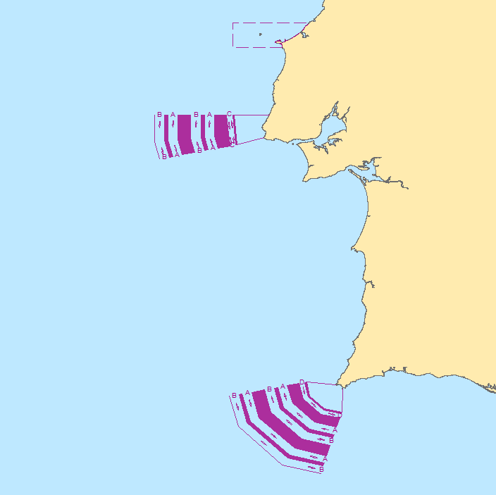
This dataset contains the Traffic Separation Schemes (TSS) for navigation safety that have been defined along the Portuguese coast, respectively Cabo da Roca TSS and Cabo de São Vicente TSS. It also includes the Area To Be Avoided (ATBA) of Berlengas.
-

The delimitation of the Port Jurisdiction Areas covers the land and sea areas, Berths and outside anchorage areas of franchise and trade. The Azores Ports Network is managed by Portos dos Açores, SGPS, S.A. The delimitation of the jurisdiction areas was approved by the Regional Legislative Decree No. 24/2011/A, of 22 August.
-
Line shapefile of all the Waiting and Loading Markings (e.g. single yellow, double yellow etc.) within the City Of Edinburgh Council administrative area backed by a Traffic Regulation Order (TRO). This data is extracted from Smallworld on a monthly basis.