Temperature of the water column
Type of resources
Available actions
Topics
INSPIRE themes
Keywords
Contact for the resource
Provided by
Years
Formats
Representation types
Update frequencies
Scale
Resolution
-
The data recorded by the oceanographic platforms operate in the Aegean and the Ionian Seas (fixed stations, ferry box system, gliders) are released through the POSEIDON portal. Physical and biochemical parameters of the marine environment as well as atmospheric parameters in the fixed station locations are available both in real time and delayed mode. The forecasting module of the POSEIDON system consists of four numerical models that provide in daily basis forecasts regarding the atmospheric, sea state, hydrodynamic and ecological conditions of the Eastern Mediterranean. The online POSEIDON database contains the data recorded by the insitu platforms offering also downloading functions for the whole data set, while a user-friendly tool is also available for accessing the results of all the forecasting models for the last five years.
-

Glider HCMR
-
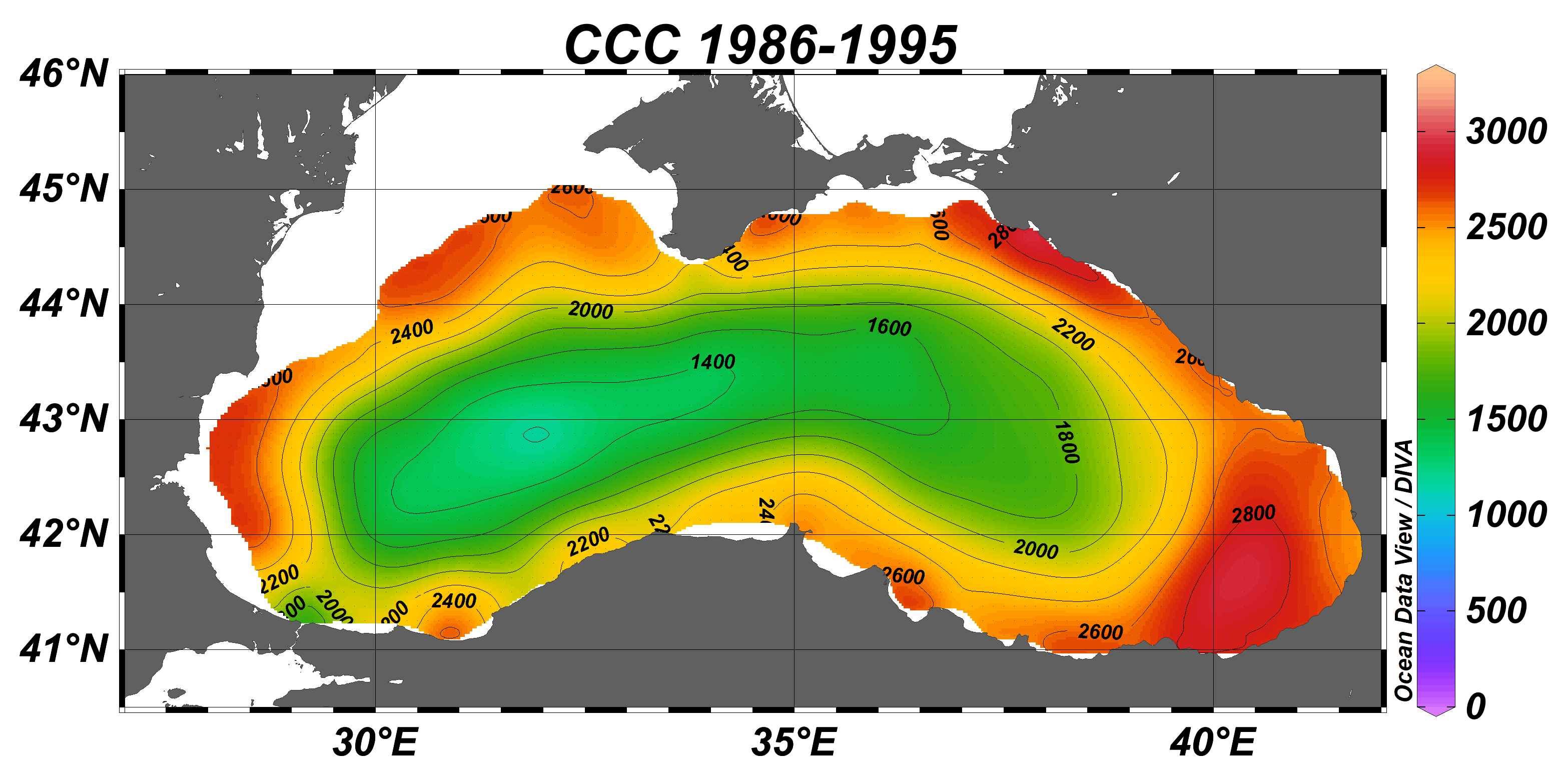
Black Sea gridded decadal annual climatology for cold intermediate layer (CIL) cold content (CCC) (1/8°, 56 sliding decades) based on the collection of temperature and salinity profiles spanning 65 years (1955–2019).The CCC climatological fields were computed from the merged Black Sea dataset that combines data extracted from 3 major sources: 1) SeaDataNet infrastructure, 2) World Ocean Database, and 3) Coriolis Ocean Dataset for Reanalysis. The computation was done with the DIVAnd (Data-Interpolating Variational Analysis in n dimensions), version 2.6.2. The product was developed in framework of SeaDataCloud project, EC H2020 grant #730960. For data access please register at http://www.marine-id.org/.
-
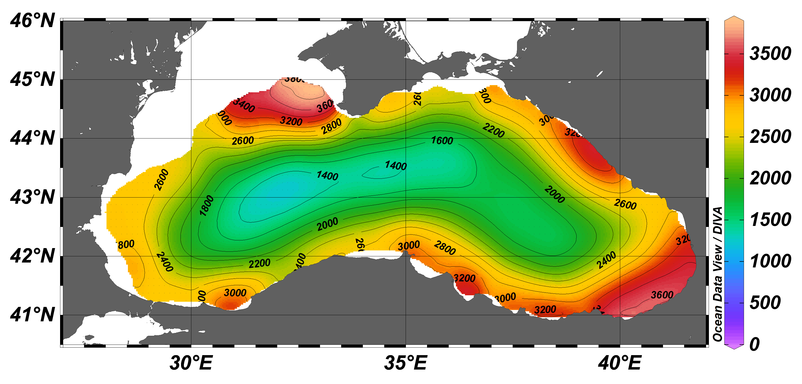
The Black Sea gridded monthly climatology for cold intermediate layer (CIL) cold content (CCC) (1/8°, 12 months) based on the collection of temperature and salinity profiles spanning 35 years (1955–1999).The CCC climatological fields were computed from the merged Black Sea dataset that combines data extracted from 3 major sources: 1) SeaDataNet infrastructure, 2) World Ocean Database, and 3) Coriolis Ocean Dataset for Reanalysis. The computation was done with the DIVAnd (Data-Interpolating Variational Analysis in n dimensions), version 2.6.2. The product was developed in framework of SeaDataCloud project, EC H2020 grant #730960. For data access please register at http://www.marine-id.org/.
-

Black Sea gridded decadal seasonal climatology for cold intermediate layer (CIL) cold content (CCC) (1/8°, 6 decades, 4 seasons) based on the collection of temperature and salinity profiles spanning 60 years (1955–2014).The CCC climatological fields were computed from the merged Black Sea dataset that combines data extracted from 3 major sources: 1) SeaDataNet infrastructure, 2) World Ocean Database, and 3) Coriolis Ocean Dataset for Reanalysis. The computation was done with the DIVAnd (Data-Interpolating Variational Analysis in n dimensions), version 2.6.2. The product was developed in framework of SeaDataCloud project, EC H2020 grant #730960. For data access please register at http://www.marine-id.org/.
-

FERRY is installed on the coastal steamer MV Vesterålen measuring T, S, Chlorophyll fluorescence and oxygen permanently as well as 30 individual samples are taken on all roundtrips from Bergen-Kirkenes and back. This roundtrip is repeated every 11 days throughout the year.
-

SYKE Alg@line project in the Baltic Sea monitors the state of the sea and detects algal blooms. Several millions of data points are collected annually from the Baltic Sea, using a fleet of 5-7 ferries. Two best equipped ferries offered in TNA are m/s Silja Serenade, which travels daily between Helsinki and Stockholm (Sweden) and m/s Finnmaid, which travels approx. twice a week from Helsinki to Travemünde (Germany) and back. Both ferries are equipped with flow-through system with thermosalinograph, chlorohyll, phycocyanin and CDOM fluorometers, turbiditymeter and refrigerated.sampling unit providing discrete water samples for laboratory analyses (e.g. microscopy, flowCAM, nutrients, optical analysis, experimental work). Additional sensors e.g. for primary production (FRRF) and light reflectance are used periodically, new sensors for light absorption and pCO2 will be soon implemented. Data can be retrieved in real time using satellite or GSM connection (basic sensors) or downloaded during harbour visits (additional sensors). Alg@line data is available e.g. through MyOcean and has also been delivered to users based on mutual cooperation, including scientific advice. Algaline ships maintained by SYKE host measurement systems from other countries, and periodically they are used as platforms for international short-term studies.
-

Oceanographic data is available in real time and delayed mode from across the NOMOS facilities. Including physical and biogeochemical variables from platforms such as moorings, floats, ferryboxes and coastal stations. The data can be accessed through Bulgarian Oceanographic Data Centre. In addition a variety of interactive tools to help visualize the data are available through the BGODC website. All data are available for download.
-

Oceanographic data is available in real time and delayed mode from across the NOMOS facilities. Including physical and biogeochemical variables from platforms such as moorings, floats, ferryboxes and coastal stations. The data can be accessed through Bulgarian Oceanographic Data Centre. In addition a variety of interactive tools to help visualize the data are available through the BGODC website. All data are available for download.
-

Oceanographic data is available in real time and delayed mode from across the NOMOS facilities. Including physical and biogeochemical variables from platforms such as moorings, floats, ferryboxes and coastal stations. The data can be accessed through Bulgarian Oceanographic Data Centre. In addition a variety of interactive tools to help visualize the data are available through the BGODC website. All data are available for download.
 Metadata catalogue