 Metadata catalogue
Temperature
Type of resources
Available actions
Topics
INSPIRE themes
Keywords
Contact for the resource
Provided by
Years
Formats
Representation types
Update frequencies
Service types
Scale
-
Monthly normals from Régional climatological network of Worl Meteorological Organisation (WMO). The period is 1981-2010. Guadeloupe - Monthly frequency - ASCII Format
-
Monthly normals from Régional climatological network of Worl Meteorological Organisation (WMO). The period is 1981-2010. Martinique - Monthly frequency - ASCII Format
-
Monthly normals from Régional climatological network of Worl Meteorological Organisation (WMO). The period is 1981-2010. Guyane - Monthly frequency - ASCII Format
-
Vertical profiles of temperature, wind, humidity, given by radiosonde, between ground and explosing level of the balloon (20 - 30 km). Data available from TEMP messages, from Global Telecommunication System of World Meteorological Organisation (WMO). This mesures are produced every day by about 10 french stations Réunion and Tromelin - avalaible for 5 last days - Once or twice a day (0Z and 12Z GMT) - ASCII Format
-

Sea Surface Temperature from Remote Sensing in North Sea and Baltic Sea
-
Sea Surface Temperature from Remote Sensing in North Sea and Baltic Sea
-

Weekly and monthly sea surface temperature of the North Sea and the Baltic Sea
-

'''Short description:''' For the Global Ocean- Gridded objective analysis fields of temperature and salinity using profiles from the reprocessed in-situ global product CORA (INSITU_GLO_TS_REP_OBSERVATIONS_013_001_b) using the ISAS software. Objective analysis is based on a statistical estimation method that allows presenting a synthesis and a validation of the dataset, providing a validation source for operational models, observing seasonal cycle and inter-annual variability. Acces through CMEMS Catalogue after registration: http://marine.copernicus.eu/ '''Detailed description:''' The operational analysis system set up by the in-situ TAC Global component operated by Coriolis data centre. It produces temperature and salinity gridded fields. The system is based on a statistical estimation method (objective analysis). This system allows presenting a synthesis and a validation of the dataset, providing a validation source for operational models, observing seasonal cycle and inter-annual variability.
-
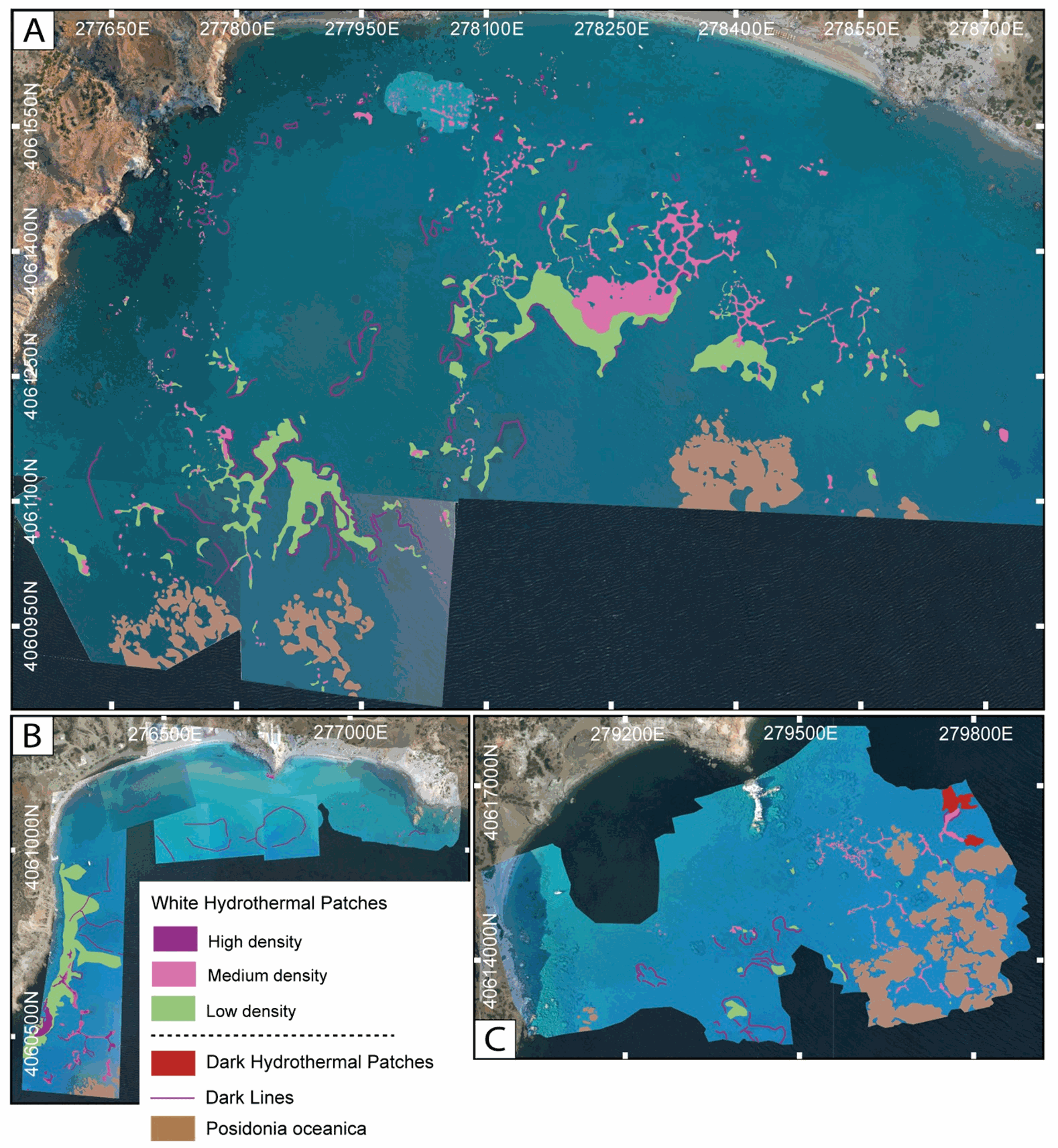
This dataset inscludes shapefiles interpreted from photomosaics over the Milos shallow water hydrothermal system, and instrument locaitons, from fieldwork in July and September 2019. The shapefiles are organized by study areas (Agia Kyria, Paleochori, and Spathi bays). Details are provided in the associated paper (Puzenat et al., 2021) in addition to information in the Readme File associated. a) Shapefiles of seafloor textures interpreted from drone imagery. b) Shapefiles of seafloor texttures interpreted from AUV imagery. c) Shapefiles of instruments deployed in the study area in September 2019.
-
The Surface Ocean CO₂ Atlas (SOCAT) is a synthesis activity for quality-controlled, surface ocean fCO₂ (fugacity of carbon dioxide) observations by the international marine carbon research community (>100 contributors). SOCAT data is publicly available, discoverable and citable. SOCAT enables quantification of the ocean carbon sink and ocean acidification and evaluation of ocean biogeochemical models. SOCAT represents a milestone in biogeochemical and climate research and in informing policy. SOCAT data are released in versions. Each succeeding version contains new data sets as well as updates of older ones. The first version of SOCAT was released in 2011, the second and third version followed biennially. Automation allowed annual public releases since version 4. The latest SOCAT version (version 5) has 21.5 million observations from 1957 to 2017 for the global oceans and coastal seas. SOCAT contains data from the VOS, OceanSites network and mooring, buoy data in general as well as calibrated sensor data.