 Metadata catalogue
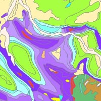
Surface geology
Type of resources
Available actions
Topics
INSPIRE themes
Keywords
Contact for the resource
Provided by
Years
Formats
Representation types
status
Service types
Scale
-

Il servizio permette la visualizzazione della Carta Geologica d'Italia alla scala 1:100.000, informatizzata. la geologia è stata accorpata in base all'eta' inferiore delle unita' geologiche, il servizio permette di visualizzare inoltre i seguenti layer: tettonica (layer di riferimento a grande scala), tracce dei profili geologici, elementi puntuali (stratimetria, sorgenti, cave, miniere, pozzi per acque e idrocarburi, localia' d'interesse geologico e sondaggi).
-
Soil-type map of Denmark 1:1 million. The map is an automatic generalization of Soilmap of Denmark 1:200.000 and a contribution to the worldwide OneGeology project. Please note that this map is fit for use as a large-scale illustration only, due to the automatic procedure used for generalization.
-
Soil-type map of Denmark 1:200.000 version 2. An interpreted overview map of surface geology in Denmark. The map shows a countrywide classification and distribution of soil types (mostly glacial and postglacial sediments) at the surface of Denmark. The soil types are divided into 12 different legend items. The map has a scale of 1:200.000, and is suited for educational use and as a background layer for other mapped themes. The map is published in GEUS report 2011/19.
-
This digital soil map shows the geology 1 meter below surface, just beneath ploughing- and culture layers. The map is digitized from redrafted maps originating from fieldwork, where soil samples are collected using a charting spear in a 100 m grid throughout the country. This map is a result of systematic geological mapping, and is an ongoing effort. This version 4.0 from 2015 classifies 88 % of Denmark's area. The legend shows 82 different soil types. The map is used for research, in relation to environmental analysis and planning of construction works, and as a basis for soil quality maps. The map is published in GEUS report 2015/30, where further information can be found.
-
The “Geological Map of Germany 1:1,000,000 OneGeology-Europe (GK1000-1GE)” shows Germany’s surface geology: All geological units are described by their age (stratigraphy) and composition (lithology). The geological units and terms used in this map were semantically harmonized within the OneGeology-Europe project and have been - in a number of regions - geometrically and semantically made consistent with the neighbouring OneGeology-Europe participants.