 Metadata catalogue
South Brazilian Shelf
Type of resources
Available actions
Topics
INSPIRE themes
Keywords
Contact for the resource
Provided by
Years
Formats
Representation types
Update frequencies
status
Resolution
-
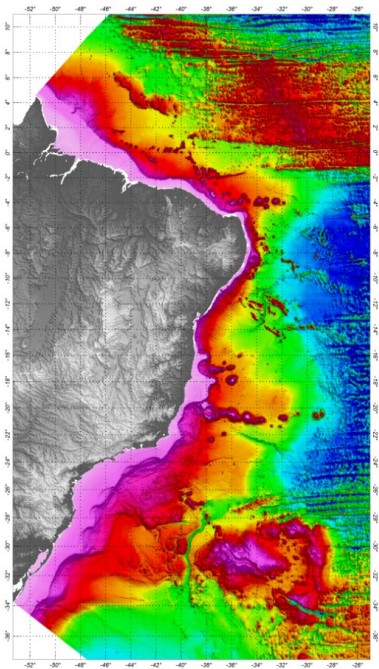
The Digital Terrain Model was developed based on all available bathymetric data, already processed and validated. The SRTM30_PLUS (Shuttle Radar Topography Mission) data were used just to complement the bathymetric grid in distal regions of the Brazilian Continental Margin. In order to prepare the bathymetric grid from a database composed by all qualified bathymetric information, it was adopted the Randgrid.GX/Geosoft - Oasis Montaj®, version 9.5.2, routine. The used mathematical model creates a surface of minimum curvature, using a similar method to that proposed by Swain (1976) and Briggs (1974), with the interpolation, in each knot of the grid, of X and Y values in metric coordinates and Z values (variable). The calculated surface adjusts itself to the irregularly sampled original values. The grid cell-size was 1,000 m, defined according the spatial distribution of the available data. The Brazilian DTM Oasis grid file was converted to surfer files, Versions V6 and V7. The ASCII file and a Geotif image were also provided. The reference system and geodetic datum adopted for the bathymetric data was the WGS84. The projection adopted was the World Mercator (false N=0, false E=0, latitude of the natural origin=0 longitude of the natural origin=0, and the scaling factor of the natural origin=1).
-
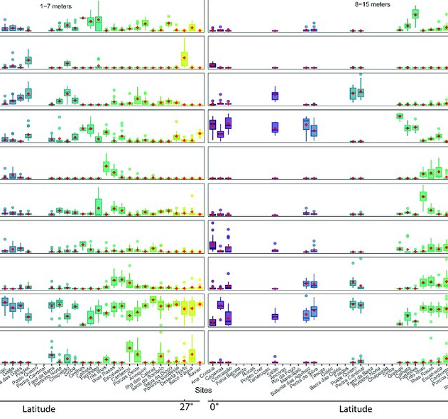
As marine ecosystems are influenced by global and regional processes, standardized information on community structure has become crucial for assessing broad-scale responses to natural and anthropogenic disturbances. Extensive biogeographic provinces, such as the Brazilian Province in the southwest Atlantic, present numerous theoretical and methodological challenges for understanding community patterns on a macroecological scale. In particular, the Brazilian Province is composed of a complex system of heterogeneous reefs and a few offshore islands, with contrasting histories and geophysical-chemical environments. Despite the large extent of the Brazilian Province (almost 8,000 kilometers), most studies of shallow benthic communities are qualitative surveys and/or have been geographically restricted. We quantified community structure of shallow reef habitats from 0° to 27°S latitude using a standard photographic quadrat technique. Percent cover data indicated that benthic communities of Brazilian reefs were dominated by algal turfs and frondose macroalgae, with low percent cover of reef-building corals. Community composition differed significantly among localities, mostly because of their macroalgal abundance, despite reef type or geographic region, with no evident latitudinal pattern. Benthic diversity was lower in the tropics, contrary to the general latitudinal diversity gradient pattern. Richness peaked at mid-latitudes, between 20°S to 23°S, where it was ~3.5-fold higher than localities with the lowest richness. This study provides the first large-scale description of benthic communities along the southwestern Atlantic, providing a baseline for macroecological comparisons and evaluation of future impacts. Moreover, the new understanding of richness distribution along Brazilian reefs will contribute to conservation planning efforts, such as management strategies and the spatial prioritization for the creation of new marine protected areas.
-

Water column sonar data, the acoustic back-scatter from the near-surface to the seafloor, are used to assess physical and biological characteristics of the ocean including the spatial distribution of plankton, fish, methane seeps, and underwater oil plumes. In collaboration with NOAA's National Marine Fisheries Service (NMFS) and the University of Colorado Boulder, NOAA’s National Centers for Environmental Information (NCEI) established a national archive for water column sonar data. This project entails ensuring the long-term stewardship of well-documented water column sonar data, and enabling discovery and access to researchers and the public around the world. Data providers include NOAA National Marine Fisheries Service (NMFS), NOAA Office of Ocean Exploration and Research (OER), NOAA National Ocean Service (NOS), Rolling Deck to Repository (R2R), U.S. academic and private institutions, and international groups. This data set comprises the water-column sonar data archived at NCEI in a more readily accessible media. Data provided to NCEI are in their raw format. Processing routines are being applied to a subset of the archive, specifically focusing on Simrad EK60 single and multiple frequency datasets. Ping alignment, noise removal algorithms (De Robertis & Higgenbottom, 2007; Ryan et al., 2015), and bottom detection algorithms are applied to the raw data binned into one hour intervals using Echoview (Myriax, v.10). The processed data are exported as a CSV for each interval and each frequency.
-

Reef fish represent one of the most diverse vertebrate groups on Earth, with over 7,000 species distributed around the globe. This richness is not evenly distributed geographically. The Atlantic (AT) and the Eastern Pacific (EP) encompass 30% of the global fish fauna. These areas have been considered the most isolated from the marine biodiversity hotspot in the Indo-Pacific due to distinct physical barriers, such as the Tethyan closure and the distance between the EP and the western Pacific. Despite their comparatively lower species richness, these realms host unique fish assemblages characterized by a remarkable proportion of regional endemics and species with large body size. Here, we present the largest database of life-history traits and biogeographical and conservation aspects presently available for the reef fish fauna of the AT and the EP realms. The database includes 21 traits distributed into behavioral (home range, diel activity, group size, level in the water column, three measures of preferred temperature), morphological (maximum body size, size class, body shape, aspect ratio, caudal fin, mouth position), and ecological (trophic level, diet, spawning strategy, depth of occurrence, two allometric constants, pelagic larval duration, and life span), as well as biogeographical (geographic range index, range extension, species distribution in 20 marine provinces, latitude north and south of occurrence, total number of provinces where species occur, occurrence in the AT and EP), and conservation aspects (IUCN status, vulnerability and global market price). We compiled these data through a careful review of 104 local checklists published between 1982 and 2020, online repositories, local reports, books, and monographs on specific families or genera. We limited our database to localities situated between latitudes 51°N and 45°S that including shallow and upper mesophotic biogenic and/or rocky reefs habitats. Our database covers 2,198 species belonging to 146 families and 655 reef fish genera distributed in two marine realms (1,458 in the AT, 829 in the EP, and 89 in both realms) and 20 marine provinces. This database of reef fish offers the opportunity to explore novel ecological and evolutionary questions at different scales and provides tools for species conservation based on these traits. There are no copyright or proprietary restrictions for research or teaching purposes.
-

3-D habitat suitability maps (HSM) or probability of occurrence maps, built using Shape-Constrained Generalized Additive Models (SC-GAMs) for the 30 main commercial species of the Atlantic region. Predictor variables for each species were selected from: sea water temperature, salinity, nitrate, net primary productivity, distance to seafloor, distance to coast, and relative position to mixed layer depth. Each species HSM contains 47 maps, one per depth level from 0 to 1000 m. Probability values of each map range from 0 (unsuitable habitat) to 1 (optimal habitat). For depth levels below the 0.99 quantile of the depth values found on the species occurrence data, NA values were assigned. Maps have been masked to species native range regions. See Valle et al. (2024) in Ecological Modelling 490:110632 (https://doi.org/10.1016/j.ecolmodel.2024.110632 ), for more details.
-
'''Short description: ''' For the '''Global''' Ocean '''Satellite Observations''', ACRI-ST company (Sophia Antipolis, France) is providing '''Chlorophyll-a''' and '''Optics''' products [1997 - present] based on the '''Copernicus-GlobColour''' processor. * '''Chlorophyll and Bio''' products refer to Chlorophyll-a, Primary Production (PP) and Phytoplankton Functional types (PFT). Products are based on a multi sensors/algorithms approach to provide to end-users the best estimate. Two dailies Chlorophyll-a products are distributed: ** one limited to the daily observations (called L3), ** the other based on a space-time interpolation: the '''"Cloud Free"''' (called L4). * '''Optics''' products refer to Reflectance (RRS), Suspended Matter (SPM), Particulate Backscattering (BBP), Secchi Transparency Depth (ZSD), Diffuse Attenuation (KD490) and Absorption Coef. (ADG/CDM). * The spatial resolution is 4 km. For Chlorophyll, a 1 km over the Atlantic (46°W-13°E , 20°N-66°N) is also available for the '''Cloud Free''' product, plus a 300m Global coastal product (OLCI S3A & S3B merged). *Products (Daily, Monthly and Climatology) are based on the merging of the sensors SeaWiFS, MODIS, MERIS, VIIRS-SNPP&JPSS1, OLCI-S3A&S3B. Additional products using only OLCI upstreams are also delivered. * Recent products are organized in datasets called NRT (Near Real Time) and long time-series in datasets called REP/MY (Multi-Years). The NRT products are provided one day after satellite acquisition and updated a few days after in Delayed Time (DT) to provide a better quality. An uncertainty is given at pixel level for all products. To find the '''Copernicus-GlobColour''' products in the catalogue, use the search keyword '''"GlobColour"'''. See [http://catalogue.marine.copernicus.eu/documents/QUID/CMEMS-OC-QUID-009-030-032-033-037-081-082-083-085-086-098.pdf QUID document] for a detailed description and assessment. '''DOI (product) :''' https://doi.org/10.48670/moi-00100