 Metadata catalogue
Seismic reflection
Type of resources
Available actions
Topics
Keywords
Contact for the resource
Provided by
Years
Formats
-

This seismic data set was recorded in September 2015 on board the R/V Pourquoi Pas? during the GHASS cruise (IFREMER) on the western Black Sea, offshore Romania. The available profiles (part of the collected data) within this deposit are located on the continental slope, bathymetry between 500 to 1200 meters. The pre-processing of the seismic data included common midpoint binning @6.25 meters, trace and shot edition, source delay correction, and a 35-375 Hz band pass filtering. Detailed Root Mean Square Velocity analyses were performed on semblance panels computed using super gathers every 150 m. Normal Move Out time correction was then applied on the Common Mid Point (CMP) using these velocities prior to stack. Interval velocities were computed using the Dix equation. The velocity model was then interpolated every CMP location, converted to depth and smoothed to perform post-stack depth migration. The depth migrated sections and the depth velocity models have been output to standard SEG-Y rev1 format (https://library.seg.org/pb-assets/technical-standards/seg_y_rev1-1686080991247.pdf) with values written using “big-endian” byte ordering and IEEE floating-point. For a given profile, both SEGY files have the same number of traces and the same bin locations. Velocity unit is in meter.second-1. The depth sampling is set to 0.5 meter for both files. The recording delay is zero for the depth migration SEGY files. The delay is coded in meters and constant for a given depth velocity SEGY file, stored within the Trace Header (bytes 109-110). Trace coordinates are also stored within the Trace Header using WGS84 +DDDMMSS.ss format with a scale factor of -100 (bytes 81-88, which means that the value has to divided by 100) . For more convenient access to the location of the profiles, these coordinates are also stored into ASCII files using decimal degrees.
-
Multibeam bathymetry and VHR seismic data acquired on the Lansdowne Bank, New Caledonia (SW Pacific)
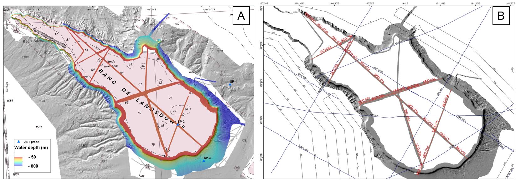
This dataset comprises multibeam bathymetry and very high resolution seismic data acquired over the Lansdowne Bank (New Caledonia, SW Pacific), during the SEDLAB cruise. The latter was a 29 day research cruise on the French national fleet ship R/V ALIS that took place in April and May 2018. The main aim was to characterise the sedimentary dynamics and the stratigraphic architecture of the Lansdowne Bank, a partly drowned, isolated rimmed carbonate platform of around 4000 km2 located offshore New Caledonia in the SW Pacific. More than 2000 km2 of new multibeam data, 7 single-channel SPARKER seismic profiles, along with 15 rock dredges and 8 sediment gravity cores were acquired on the bank top and adjacent slopes. These data reveal that the bank is typified by an almost continuous 4 km wide reef rim located in ca. 50 m water depth, showing typical “spurs and grooves” patterns. This outer rim surrounds a paleolagoon that gently deepens towards the inner platform, reaching up to 100 m water depth. Pinnacle reefs, up to 20 m high, are common close to the external reef rim, but are also scattered within the inner platform. Surprisingly, no obvious transfer axes across the reef rims, internal channels, tidal shoals or any clear current-related bedforms were imaged on the bank top. The bank is bordered by very steep slopes showing numerous bypass features such as canyons, channels and gullies. Additionally, spectacular bank margin collapses were identified. They are evidenced by up to 10 km wide intraslope and bank edge failure scarps, resulting in a scalloped geometry of the bank margin. Scarps are associated with km-sized blocks at the base-of-slope. Integration of all surface and subsurface data, together with post-cruise sedimentological, biostratigraphic and radiometric analyses on rock and sediment samples will hopefully bring new insight into the onset, aggradation and drowning history of the platform in relation to past sea-level changes and vertical tectonic movements. We believe that such results are relevant for the understanding of carbonate slope processes as well as platform-to-basin sediment budgets.