 Metadata catalogue
Seismic
Type of resources
Available actions
Topics
Keywords
Contact for the resource
Provided by
Years
Formats
-
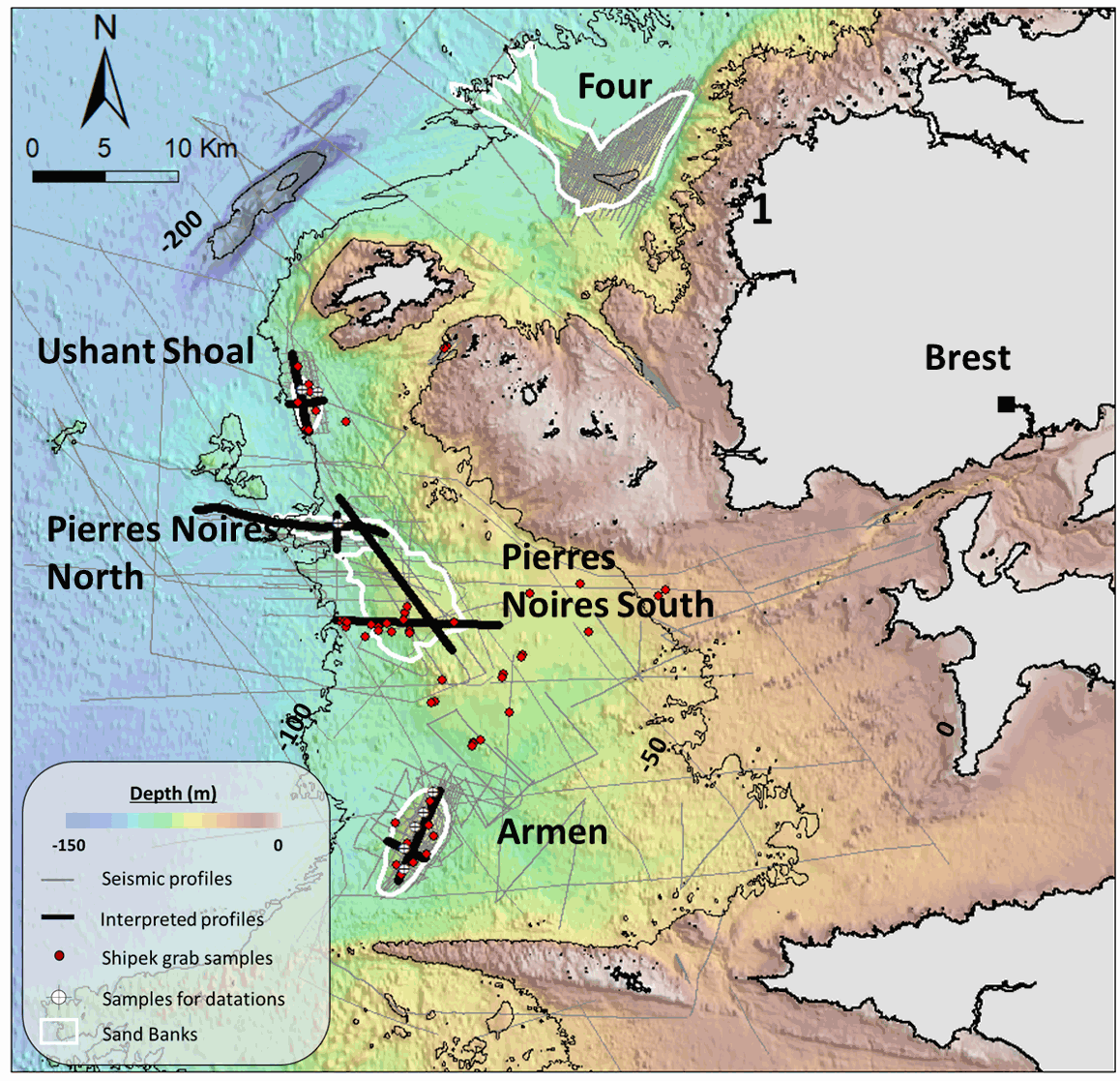
This seismic dataset came from surveys carried out by the “Institut Universitaire Européen de la Mer” (IUEM, UBO) and the Ifremer, on the Iroise Sea platform, (Western Brittany, France). Two main files are provided here: -The first one is composed of the 10 seismic profiles described in the article "Long term evolution of deep banner banks offshore Western Brittany (Iroise Sea, France): indications of a paleo-coast line and of the interaction between hydrodynamics and seafloor morphology", with tiff and SEG Y / NAV data. The second is composed of SEGY files over the whole platform from several research cruises (GEOBREST (11, 12, 13, 14,15, 19), SpeeDunes, Bankable, SABASETI). .Nav files are the XY coordinates of each seismic line. For each SEGY fil there is both a non-corrected and a corrected version (name of the file finishing by PRC).Each data file is accompanied by other files with the same name (for example .GEO .PRM ...) that are necessary to open the corrected version. An integrated approach combining seismic, bathymetry and sediment analyses acquired over the last 10 years aims to understand the main factors driving the sand banks growth and internal architecture, as well as their anchoring and stability at a depth of almost -100m since the last deglaciation.
-

This seismic data set was recorded in September 2015 on board the R/V Pourquoi Pas? during the GHASS cruise (IFREMER) on the western Black Sea, offshore Romania. The available profiles (part of the collected data) within this deposit are located on the continental slope, bathymetry between 500 to 1200 meters. The pre-processing of the seismic data included common midpoint binning @6.25 meters, trace and shot edition, source delay correction, and a 35-375 Hz band pass filtering. Detailed Root Mean Square Velocity analyses were performed on semblance panels computed using super gathers every 150 m. Normal Move Out time correction was then applied on the Common Mid Point (CMP) using these velocities prior to stack. Interval velocities were computed using the Dix equation. The velocity model was then interpolated every CMP location, converted to depth and smoothed to perform post-stack depth migration. The depth migrated sections and the depth velocity models have been output to standard SEG-Y rev1 format (https://library.seg.org/pb-assets/technical-standards/seg_y_rev1-1686080991247.pdf) with values written using “big-endian” byte ordering and IEEE floating-point. For a given profile, both SEGY files have the same number of traces and the same bin locations. Velocity unit is in meter.second-1. The depth sampling is set to 0.5 meter for both files. The recording delay is zero for the depth migration SEGY files. The delay is coded in meters and constant for a given depth velocity SEGY file, stored within the Trace Header (bytes 109-110). Trace coordinates are also stored within the Trace Header using WGS84 +DDDMMSS.ss format with a scale factor of -100 (bytes 81-88, which means that the value has to divided by 100) . For more convenient access to the location of the profiles, these coordinates are also stored into ASCII files using decimal degrees.
-
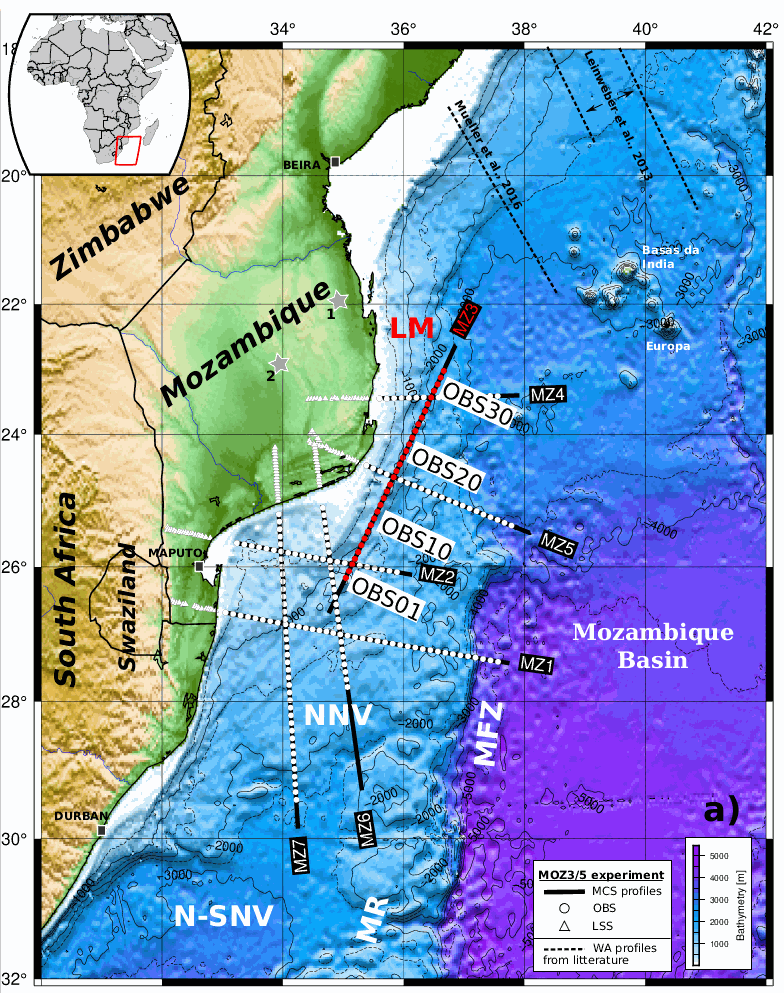
Coincident wide-angle and multi-channel seismic data acquired within the scope of the PAMELA Moz3-5 project allow to reconsider the formation mechanism of East-African margins offshore southern Mozambique. This study most specifically focuses on the sedimentary and deep crustal architecture of the Limpopo margin (LM) that fringes the eastern edge of the Mozambique’s Coastal Plain (MCP) and its offshore southern prolongation the North Natal Valley (NNV). It relies primarily on the MZ3 profile that runs obliquely from the northeastern NNV towards the Mozambique basin (MB) with additional inputs from a tectono-stratigraphy analysis of industrial onshore-offshore seismic lines and nearby or crossing velocity models from companion studies. Over its entire N-S extension the LM appears segmented in (1) a western domain that shows the progressive eastward crustal thinning and termination of the MCP/NNV continental crust and its overlying pre-Neocomien volcano-sedimentary basement; and (2) a central corridor of anomalous crust bounded to the east by the Mozambique fracture zone (MFZ) and the oceanic crust of the MB. A prominent basement high marks the boundary between these two domains. Its development was most probably controlled by a steep and deeply rooted fault, i.e. the Limpopo fault. We infer that strike-slip or slightly trans-tensional rifting occurred along the LM and was accommodated along this Limpopo fault. At depth we propose that ductile shearing was responsible for the thinning of the continental crust and an oceanward flow of lower crustal material. This process was accompanied by intense magmatism that extruded to form the volcanic basement and gave to the corridor its peculiar structure and mixed nature. The whole region remained at a relative high level during the rifting period and a shallow marine environment dominated the pre-Neocomien period during the early phase of continent-ocean interaction. It is only some times after break-up in the MB and the initiation of the MFZ that decoupling occurred between the MCP/NNV and the corridor allowing for the latter to subside and being covered by deep marine sediments. A scenario for the early evolution and formation of the LM is proposed taking into account both recent kinematic and geological constraints. It implies that no or little changes in extensional direction occurred between the intra-continental rifting and subsequent phase of continent-ocean interaction.
-
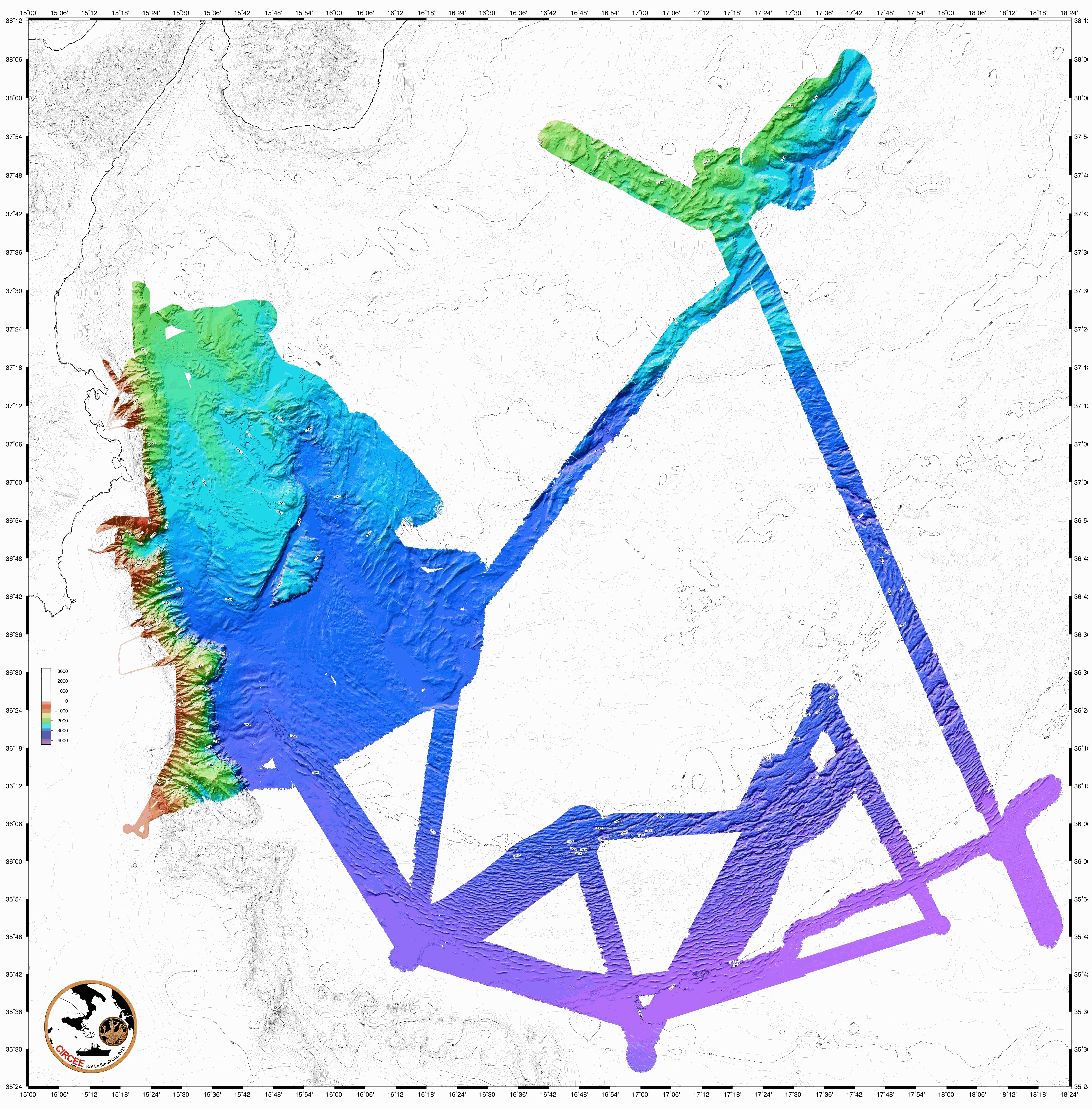
The following data were acquired in 2013 by the french research vessel N/O Suroit during the CIRCEE cruise (see the cruise report): - High-resolution 72-trace seismic data. The files are available in the segy format. A map is provided to locate the 1500 km of seismic profile acquired. - Gridded bathymetry data (resolution : 90m) available in GRD format (software GMT Generic Mapping Software de Wessel & Smith based on NetCDF libraries). A map is available. - Bathymetry data from multibeam echo sounder Kongsberg-Simrad EM302. The data are available in the raw data mbg and include the travel time and amplitude (reflectivity). - Highfrequency chirp-sonar data. The files are available in the segy format. A map is available in the cruise report.
-
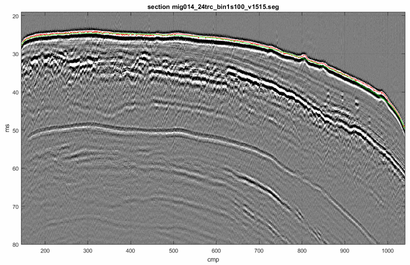
Seismic profile ST5-014 was acquired in May 2015 during the STEP 2015 cruise (DOI:10.17600/15006100) on the continental shelf offshore Nice Airport (SE France). The source was a 1200 J Sparker from Geo Marine Survey with electrical pulse on a 400 tip electrode. The seismic data were recorded on a Geo-sense 48-channel streamer of 230 m long with a trace spacing of 3.125 m which was towed at a depth of 0.6 m. One Automatic Identification System was deployed on the seismic source and two others on the head and tail of the streamer to ensure positioning with meter accuracy. The pre-processing of the seismic data included common midpoint binning, spherical divergence correction, 125-2500 Hz bandpass filtering, normal moveout correction and signature deconvolution. To preserve the high frequency content of the source only the first 24 traces were stacked (i.e. maximum offset of 80 m). This provided seismic data with a frequency range of 175 to 850 Hz. Detailed Root Mean Square velocity analyses were performed on super gathers every 1 m. After the picking of velocities on semblance panels, interval velocities were computed using the Dix equation. Stack and post-stack time migration were then applied using this velocity field. The time-migrated seismic data were converted to standard SEG-Y rev1 format (https://seg.org/Portals/0/SEG/News%20and%20Resources/Technical%20Standards/seg_y_rev1.pdf) with values written using “big-endian” byte ordering and IEEE floating-point. Seismic coordinates in trace headers are in WGS84 format and +DDDMMSS.ss unit (with a scale factor of -100).
-
This archive includes wide-angle seismic data from profiles 1, 2, 3 and 2 of the MARGATS cruise offshore French Guyana and Surinam including navigation files. The objective is more precisely to characterize the crustal structure and evolution of marginal plateaux, sub-marine reliefs that are associated to 30 % of the transform margins in the world. These reliefs are systematically observed at the junction of different ages in relay zones between divergent and transform segments. Their building remains enigmatic although they represent reliefs established in geodynamical nubs that are keys ton understand the localisation of transform margins. This project MARGATS intend to image the deep structure of the marginal plateau (wide angle seismic and multichannel seismic MCS). The experimental site proposed is the Demerara plateau offshore French Guyana and Surinam and located at the junction between Central Atlantic locally opened in a divergent mode and Equatorial Atlantic opened mainly in transform mode in the area. Hence, this plateau has recorded at its different borders the divergent opening of the central Atlantic and the tranform opening of the Equatorial Atlantic. It may be this situation itself that leads to the formation of the plateau, but it requires to precisely constraint its deep internal structure. Finally the Demerara plateau is one of the more studied with petroleum seismic data and high resolution seismic data. It is then one of the ideal place to conduct a high resolution wide-angle deep seismic survey.
-
2D seismic lines from Haiti-sis 1&2 cruises. Processed and interpreted lines.
-
Multibeam bathymetry and VHR seismic data acquired on the Lansdowne Bank, New Caledonia (SW Pacific)
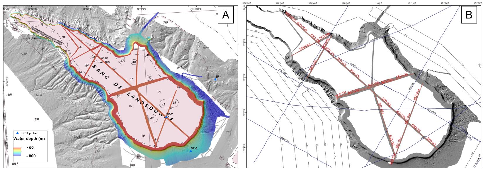
This dataset comprises multibeam bathymetry and very high resolution seismic data acquired over the Lansdowne Bank (New Caledonia, SW Pacific), during the SEDLAB cruise. The latter was a 29 day research cruise on the French national fleet ship R/V ALIS that took place in April and May 2018. The main aim was to characterise the sedimentary dynamics and the stratigraphic architecture of the Lansdowne Bank, a partly drowned, isolated rimmed carbonate platform of around 4000 km2 located offshore New Caledonia in the SW Pacific. More than 2000 km2 of new multibeam data, 7 single-channel SPARKER seismic profiles, along with 15 rock dredges and 8 sediment gravity cores were acquired on the bank top and adjacent slopes. These data reveal that the bank is typified by an almost continuous 4 km wide reef rim located in ca. 50 m water depth, showing typical “spurs and grooves” patterns. This outer rim surrounds a paleolagoon that gently deepens towards the inner platform, reaching up to 100 m water depth. Pinnacle reefs, up to 20 m high, are common close to the external reef rim, but are also scattered within the inner platform. Surprisingly, no obvious transfer axes across the reef rims, internal channels, tidal shoals or any clear current-related bedforms were imaged on the bank top. The bank is bordered by very steep slopes showing numerous bypass features such as canyons, channels and gullies. Additionally, spectacular bank margin collapses were identified. They are evidenced by up to 10 km wide intraslope and bank edge failure scarps, resulting in a scalloped geometry of the bank margin. Scarps are associated with km-sized blocks at the base-of-slope. Integration of all surface and subsurface data, together with post-cruise sedimentological, biostratigraphic and radiometric analyses on rock and sediment samples will hopefully bring new insight into the onset, aggradation and drowning history of the platform in relation to past sea-level changes and vertical tectonic movements. We believe that such results are relevant for the understanding of carbonate slope processes as well as platform-to-basin sediment budgets.
-
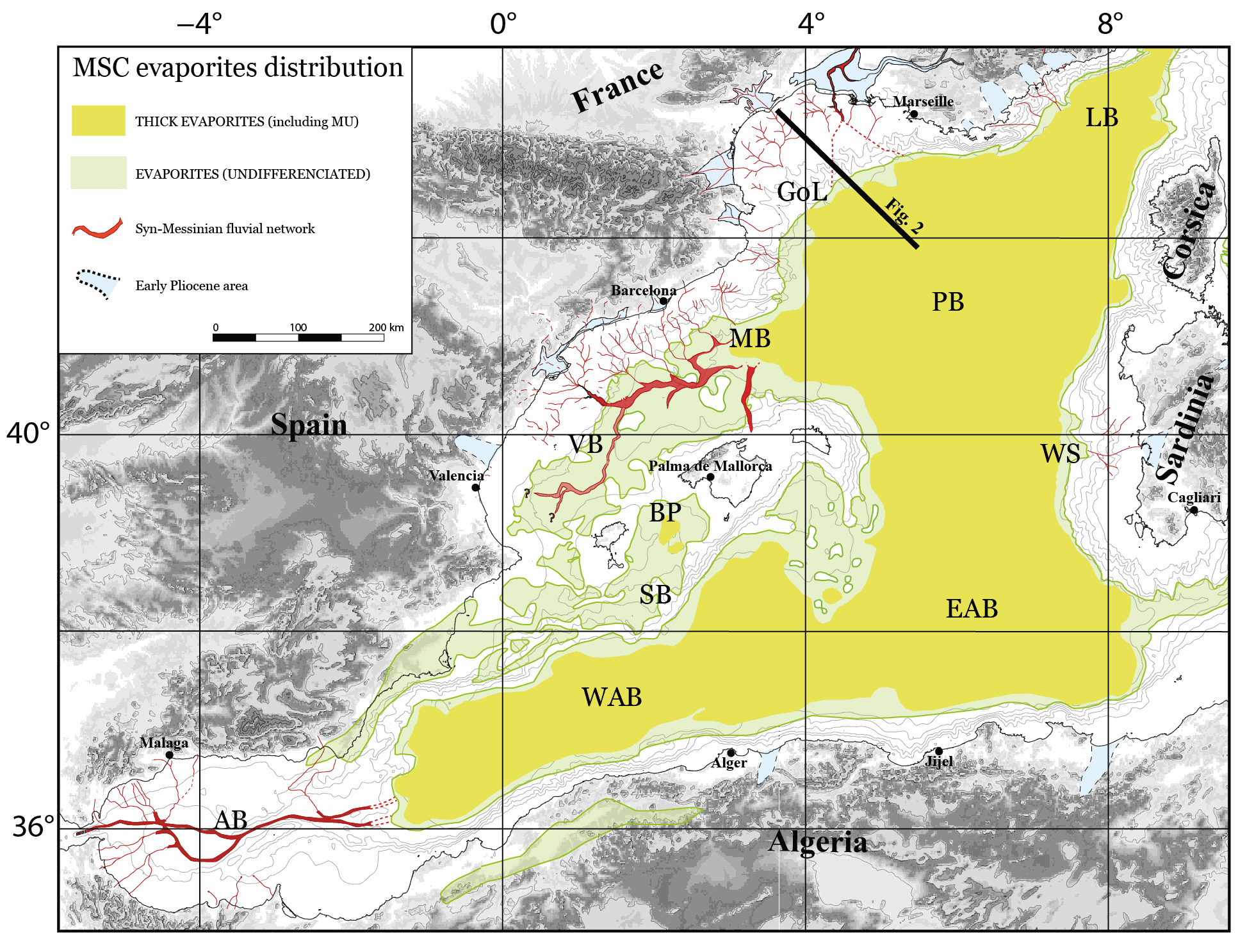
The Western Mediterranean Sea is a natural laboratory to address questions about the formation and evolution of continental margins and the relationship between surface and deep processes. The evaporites deposited during the late Miocene’s Messinian Salinity Crisis (MSC) strongly impact its sedimentological and geomorphological evolution. Hereafter, we present a compilation of some of the main regional seismic stratigraphic markers throughout the Western Mediterranean Sea. We provide in xyz format (z in second twt) the original, not interpolated, points interpretation of the following horizons: i) Acoustic basement, ii) Base and Top of the MSC salt, also known as Mobile Unit (MU), iii) base Pliocene and iv) Seafloor. The available reflection seismic dataset, coming from a collaboration between French, Spanish, Algerian and Italian research institutes, covers most of the Western Mediterranean sub-basins with the exception of the Ligurian Basin. This compilation is currently the most comprehensive and updated available in literature and provides a useful contribution to the scientific community working in sedimentary, tectonics and geodynamics studies in the Western Mediterranean Sea.
-
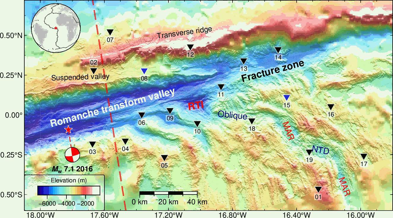
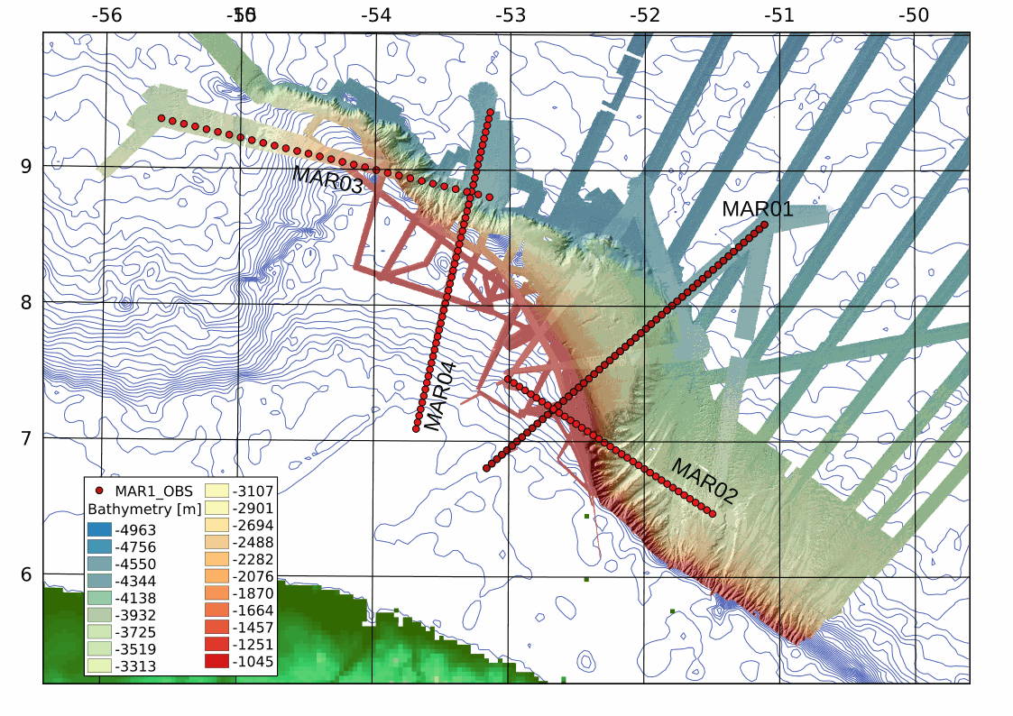
This dataset contains seismic data from 17 OBS collected in the equatorial Atlantic Ocean during the SMARTIES cruise in 2019. 12 OBSs are located along the eastern Romanche transform and fracture zone, and 5 OBSs are located along the Mid-Atlantic Ridge. The OBS data are vertical components and recorded in MiniSEED format. The data collection started from 2019-07-20T00:00:00 to 2019-08-16T24:00:00. This dateset includes raw data from OBS #10 to OBS#19. OBS#15 recorded no data. Data from OBS#1 to OBS#9 are available from a companion dataset. OBS#8 was lost.