 Metadata catalogue
Seafloor mapping
Type of resources
Available actions
Topics
INSPIRE themes
Keywords
Contact for the resource
Provided by
Years
Formats
Representation types
-
Submarine fault scarp and traces of earthquake (Roseau Fault, French Antilles): 3D scene and imagery
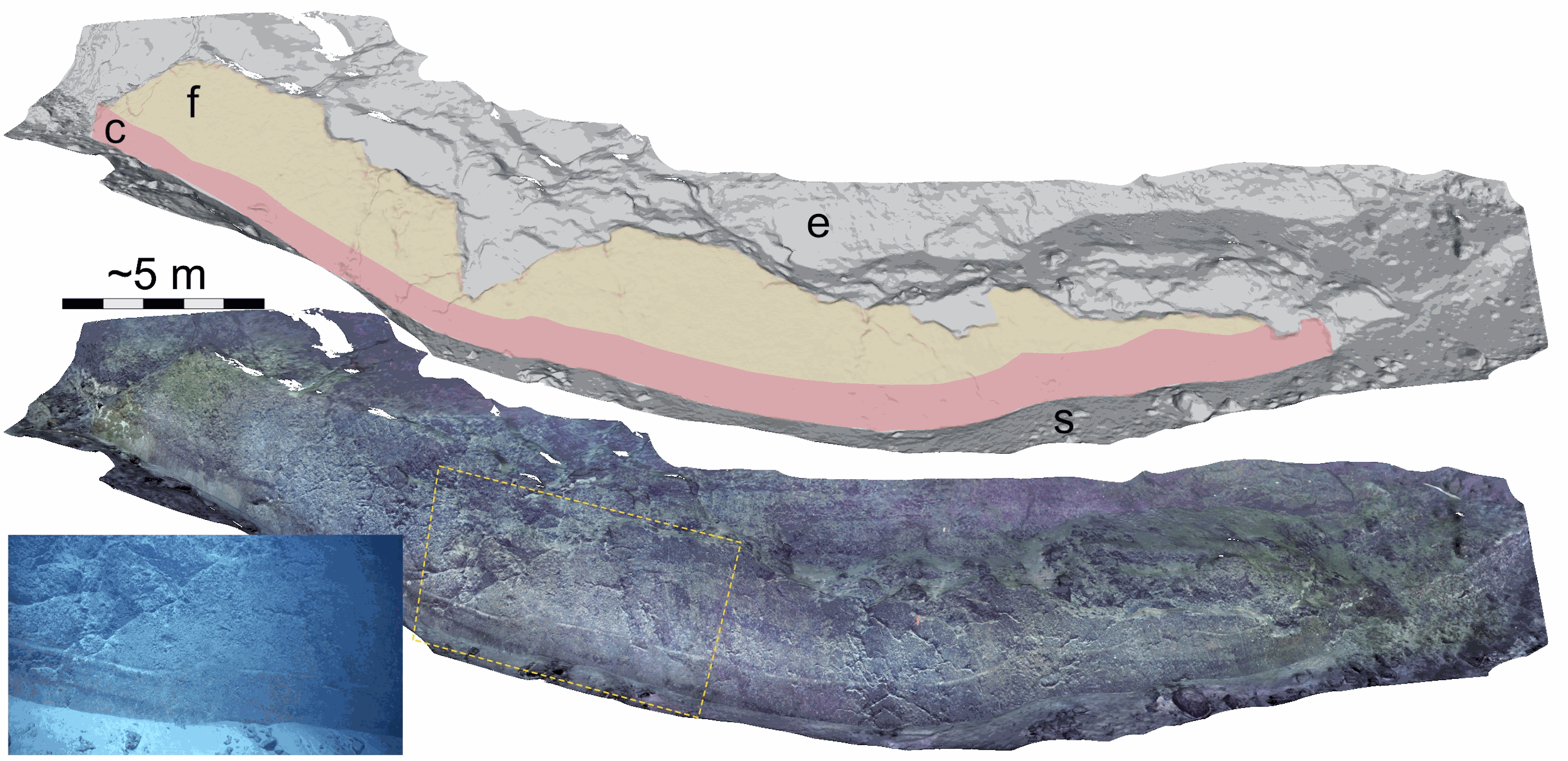
Fault scarp along the Roseau normal fault between Les Saintes and Dominica (French Antilles), at a water depth of 1100 m. This fault scarp is sub-vertical and at its base displays a marker that corresponds to the exposed fault plane during the 2004 Les Saintes Earthquake. The model shows here a coseismic displacement of ~1 m. This scarp was one of several surveyed along the Roseau Fault rupture during the Subsaintes cruise (https://doi.org/10.17600/17001000), with ROV Victor 6000 equipped with an HD Video camera. Two datasets are provided. First, the survey imagery, with a video (mp4 format) and an associated navigation file in txt format. Second, a 3D textured model of the site (obj format), together with the a kml file for georeferencing, and a geotiff orthomosaic. This dataset is one of several sets released with a paper by Arnaubec et al. (submitted March 2021, Computer and Geosciences) presenting the Matisse image processing software, and the 3DMetrics Visualization and analysis software (ref Github to come).
-
The EuroMapApp task of the AtlantOS project aims to integrate Europe’s existing and future bathymetric data sets from the Atlantic Ocean into a seamless whole and put these results into a widely accessible format allowing immediate visualization of the seafloor for the specialist and non-specialist user alike. The partner institutions are GEOMAR, Ifremer, NIOZ, and NERC-BODC.
-
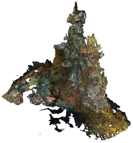
The Capelinhos hydrothermal vent site is a large edifice of 588 m² from its base. Located off axis, 1.5 km east of the central lava lake of the main Lucky Strike Hydrothermal Vent Field (mLSHVF), it is characterised by distinct geochemical and thermal conditions from the others mLSHVF edifices, with notably high iron concentrations compared to sites around the lava lake. The edifice has been surveyed with the remotely operated vehicle Victor6000 for inter-annual monitoring during the 2023 Momarsat cruise. Video transects were collected during dive 844-6 with a forward-looking camera and video sequences were used to build 3D models of the edifice using structure-from-motion techniques. A first dataset includes 2971 images extracted every 2 seconds from the videos. The images are time-stamped and linked to a navigation file, which is generated by interpolating navigation data at the corresponding timestamps. A second dataset includes a 3D textured model of the site (obj format) together with the a kml file for georeferencing. The ROV navigation file (.txt) is provided separately. Point : 37.28948183 (lat) -32.26413676 (long) -1663.487 (depth)
-

The Sintra hydrothermal vent site reconstructed in this dataset is 311.82 m². It is located in the North east of the main Lucky Strike Hydrothermal Vent Field (LSHF). The edifice has been surveyed with the remotely operated vehicle Victor6000 for inter-annual monitoring during the 2023 Momarsat cruise. Video transects were collected during dive 844-6 with a forward-looking camera and video sequences were used to build a 3D model of the edifice using structure-from-motion techniques. A first dataset includes 1561 images extracted every 2 seconds from the videos. The images are time-stamped and linked to a navigation file, which is generated by interpolating navigation data at the corresponding timestamps. A second dataset includes a 3D textured model of the site (obj format) together with the a kml file for georeferencing. The ROV navigation file (.txt) is provided separately. Point : 37.2921244612 (lat) -32.2750499167 (long) -1612.34 (depth)
-
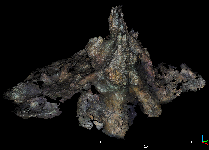
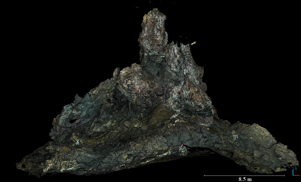
The Eiffel Tower active hydrothermal chimney is a major edifice investigated in deep-sea vent ecology at the Lucky Strike hydrothermal field (~ -1700 m), along the northern Mid-Atlantic Ridge (37.3°N, 32.3°W). This edifice, raising ~20 m over the surrounding seafloor, is associated with black smoker fluids flowing at >300°C as well as diffusion areas colonized by large Bathymodiolus azoricus mussel assemblages and microbial mats. This vent edifice was surveyed with vertical overlapping transects by ROV Victor6000 using an HD camera during the MoMARSAT2018 cruise. This dataset is part of a larger temporal series performed with other 3D reconstructions at the Eiffel Tower hydrothermal edifice that was used to investigate temporal dynamics of the edifice topography and the vent assemblages (Van Audenhaege et al. in prep.; see section "Note").
-
The Eiffel Tower active hydrothermal chimney is a major edifice investigated in deep-sea vent ecology at the Lucky Strike hydrothermal field (~ -1700 m), along the northern Mid-Atlantic Ridge (37.3°N, 32.3°W). This edifice, raising ~20 m over the surrounding seafloor, is associated with black smoker fluids flowing at >300°C as well as diffusion areas colonized by large Bathymodiolus azoricus mussel assemblages and microbial mats. This vent edifice was surveyed with vertical overlapping transects by ROV Victor6000 using an HD camera during the MoMARSAT2020 cruise. This dataset is part of a larger temporal series performed with other 3D reconstructions at the Eiffel Tower hydrothermal edifice that was used to investigate temporal dynamics of the edifice topography and the vent assemblages (Van Audenhaege et al. in prep.; see section "Note").