 Metadata catalogue
Quaternary
Type of resources
Topics
INSPIRE themes
Keywords
Contact for the resource
Provided by
Years
Formats
Representation types
Update frequencies
status
Service types
Scale
-
This layer of the Map based index (GeoIndex) shows the location of available UTM (Universal Transverse Mercator) series 1:250000 geological maps. These maps display Bedrock, Quaternary (Superficial deposits) geology of the offshore areas and Seabed Sediments of the UK landmass and offshore regions. The different versions are normally published as separate maps for land areas, but these may be combined on a single map for offshore areas. Maps are normally available in flat and folded format. The UTM Series (Universal Transverse Mercator projection) maps cover an area of 1deg. latitude by 2deg. longitude.
-
Soil-type map of Denmark 1:200.000 version 2. An interpreted overview map of surface geology in Denmark. The map shows a countrywide classification and distribution of soil types (mostly glacial and postglacial sediments) at the surface of Denmark. The soil types are divided into 12 different legend items. The map has a scale of 1:200.000, and is suited for educational use and as a background layer for other mapped themes. The map is published in GEUS report 2011/19.
-
This digital soil map shows the geology 1 meter below surface, just beneath ploughing- and culture layers. The map is digitized from redrafted maps originating from fieldwork, where soil samples are collected using a charting spear in a 100 m grid throughout the country. This map is a result of systematic geological mapping, and is an ongoing effort. This version 4.0 from 2015 classifies 88 % of Denmark's area. The legend shows 82 different soil types. The map is used for research, in relation to environmental analysis and planning of construction works, and as a basis for soil quality maps. The map is published in GEUS report 2015/30, where further information can be found.
-
Tertiary geological map of Flanders (Belgium), scale 1/50.000. It is a subcrop map of the Tertiary formations under the Quaternary erosion surface.
-
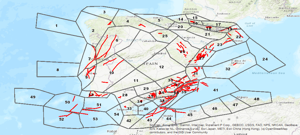
Database visualization service of seismogenic zones of the Iberian Peninsula and territories of influence for the calculation of seismic hazard in Spain (ZESIS)