 Metadata catalogue
Pigments
Type of resources
Available actions
Topics
INSPIRE themes
Keywords
Contact for the resource
Provided by
Years
Formats
Representation types
Scale
-
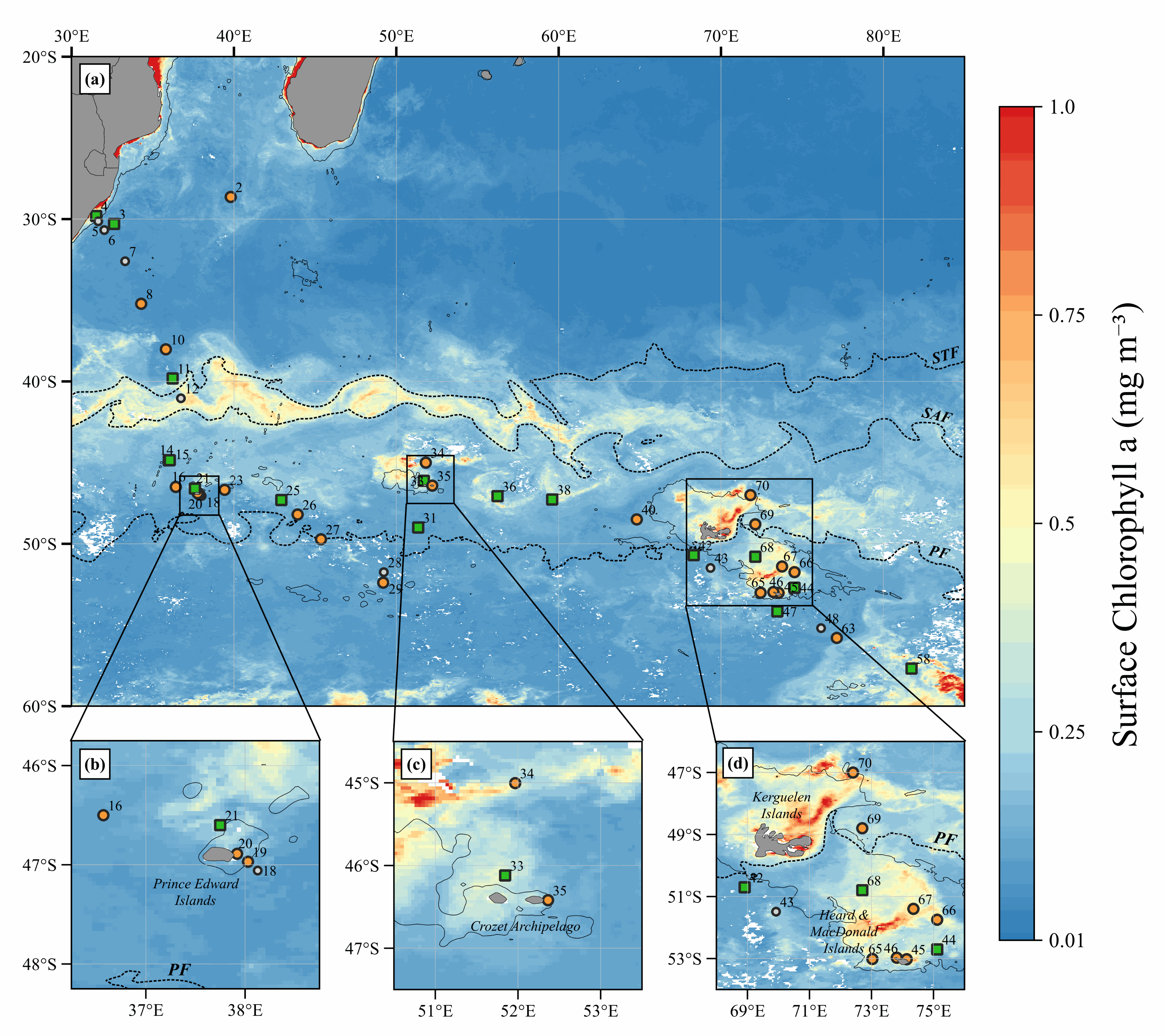
Data of parameters presented as figures in the manuscript: Biogenic silica (BSi: µmol.L-1), Lithogenic silicon (LSi: µmol.L-1), Total Chlorophyll a (TChla: mg.m-3) and Fucoxanthin (Fuco: mg.m-3). Note that: - Total fraction for BSi and LSi is available from Niskin bottles (> 0.8 µm) and in situ pumps (> 0.45 µm); - Size-fractions for BSi and LSi is available from in situ pumps only (5-53 µm; > 53 µm); - Total fraction for TChla and Fuco is available from Niskin bottles (> 0.7 µm). - Integrated data (0-200 m) is available from Niskin Bottles. Acronym explanations: - Sampling type: ISP = In Situ Pump; ISP-SF = In Situ Pump with Size-Fraction; NSK = Niskin. - Method used for BSi and LSi computation: NOC = No Correction applied; RAG = Correction using the method used from the protocol established by Ragueneau et al. (2005); ACR = Average Crustal Ratio method used when one of the criterion from the protocol established by Ragueneau et al. (2005) is not respected. - bdl = Below Detection Limit For further explanations in the method, should you please refer to the Material and Methods section in the manuscript (revised version submitted in Marine Chemistry).
-
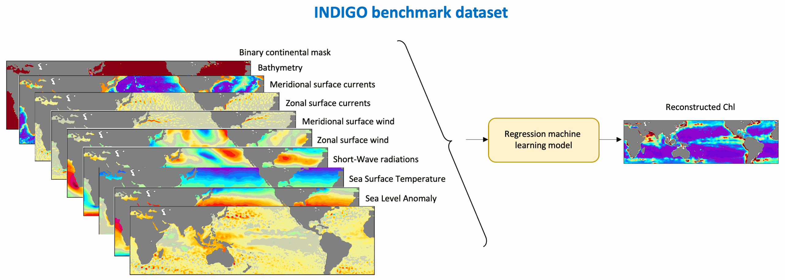
This benchmark dataset contains the physical data used as predictors to reconstruct global chlorophyll-a concentrations (Chl, a proxy of phytoplankton biomass) in Roussillon et al., as well as the reference satellite Chl target fields. The nine physical predictors' data (Short-Wave radiations, Sea Surface Temperature, Sea Level Anomaly, Zonal and meridional surface currents, Zonal and meridional surface wind stress, Bathymetry, Binary continental mask) were extracted from publicly available datasets over [1998-2015] and resampled to the same spatio-temporel resolution as Chl, i.e. monthly on a 1°x1° grid between 50°N and 50°S. Missing values were gap-filled using the heat diffusion equation. Each variable was normalized by substracting its mean from the original values and dividing by its standard deviation over [1998-2015]. This dataset was used to train and validate the Multi-Mode Convolutional Neural network (CNNMM8) introduced in Roussillon et al. ; reconstructed monthly Chl fields over the [2012-2015] test period are also provided here. We hope this benchmark dataset can help to promote the improvements of methods as well as the emergence of new ideas, as building datasets is sometimes more time-consuming than the implementation of machine learning tools themselves. This would also facilitate the quantitative comparison of models performances' on the exact same datasets.
-
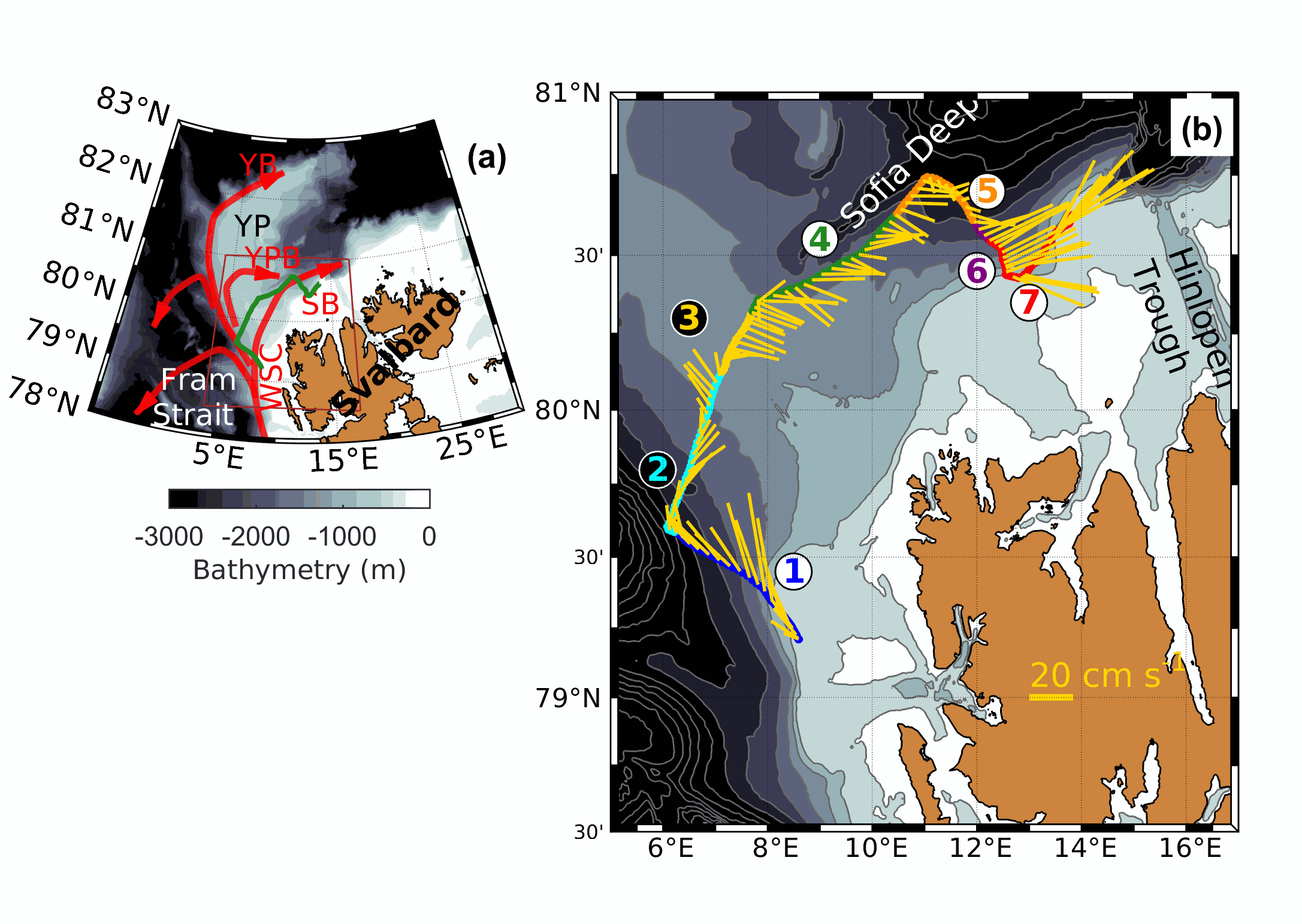
The SeaExplorer glider Sea028 was deployed from the research vessel R/V Lance on the 15 September 2017 at 79.5°N, 8.6°E, on the western slope of Svalbard. The glider was recovered on 23 September 2017 at 80.62°N, 13.83°E.The glider was equipped with a GPCTD (Glider Payload Conductivity Temperature Depth from SeaBird), a dissolved oxygen sensor (Sea Bird SBE43F), and an optical sensor measuring Chlorophyll a (470/695 nm), Colored Dissolved Organic Matter (CDOM, 370/460 nm), and the total particle concentration or backscatter (backscattering at 700 nm) (EcoPuck from Wetlabs). The dataset is composed of the data corrected from the thermal lag and the sensor lag, despiked and interpolated every 1m. The profiles are separated.
-

Créée en 2016, l'infrastructure de recherche littorale et côtière (ILICO) vise à observer et comprendre les milieux et les écosystèmes côtiers et marins dans leur globalité. Ainsi, ILICO regroupe un ensemble de dispositifs d'observation permettant de collecter des échantillons et de déployer différents instruments de mesure en fédérant 9 services d'observation, dit "réseaux élémentaires" que sont : BenthOBS, COAST HF, CORAIL, DYNALIT, MOOSE, PHYTOBS, ReefTemps, SOMLIT et SONEL. La réalisation de suivis à long terme permet également de faciliter la compréhension et l'anticipation de certains processus et phénomènes à grandes échelles qui peuvent impacter les zones côtières et littorales (quantification de l’impact de certains événements extrêmes ou intermittents tels que les tsunamis ou les cyclones).