 Metadata catalogue
Oceanographic geographical features
Type of resources
Available actions
Topics
INSPIRE themes
Keywords
Contact for the resource
Provided by
Years
Formats
Representation types
Update frequencies
status
Service types
Scale
Resolution
-

SpiArcBase is a software developed for the treatment of Sediment Profile images (SPIs). Sediment Profile Images (SPIs) are widely used for benthic ecological quality assessment under various environmental stressors. The processing of the information contained in SPIs is slow and its interpretation is largely operator dependent. SpiArcBase enhances the objectivity of the information extracted from SPIs, especially for the assessment of the apparent Redox Potential Discontinuity (aRPD). This software allows the user to create and manage a database containing original SPIs and corresponding derived pieces of information. Once you have downloaded it, you can ask for help and stablish a helpdesk.
-

CABLE is an infrastructure with a suite of physical biological and chemical sensors that involves and impacts several scientific fields and is expected to stimulate innovation and new research. The main driver is the capability of real time monitoring and the possibility to act in accordance with observations. Coupled information is a requirement in most research that aims at understanding function and dynamics of the marine environment and associated marine life as well as assessing impacts due human activity. Cable and node of the Cabled based observatory were launched in spring 2013.
-
Sediment Profile Images (SPIs) are commonly used to map physical, biological and chemical/nutrient gradients in benthic habitats. SpiArcBase is a software that has been developed for the analysis of Sediment Profile Images (SPIs). It has been conceived to improve the objectivity of extracted information (especially the apparent Redox Potential Discontinuity (aRPD). The software presents a graphical user interface designed to enhance the interpretation of features observed on SPIs in an objective manner and to facilitate image management and structures visualization via a data base.The software also allows for the storage of generated data and the automatic computation of a benthic habitat quality index. The facilities provided within JERICONext include access to the software through free downloading and assistance in its utilization.
-
The Non-Native Species (NNS) tool, to be developed using R-shiny, will allow users to map the distribution of non-native species across the UK seas, using data from 777 benthic surveys (33,198 samples). These data come from the ‘big data’ study of Cooper and Barry (2017). The tool will be made available on the existing www.benthosapps.net website. This site will offer a number of benthic related tools, allowing users (industry, government, public) to interact with existing benthic datasets and associated data products. On the website, tools can be bundled together into industry specific applications. See, for example, the Marine Aggregates Application (MAPP), https://www.benthosapps.net/ma_tool/. In due course, it is planned to produce similar applications for other industry sectors.
-
HF Radar System
-
This product of the Basque Operational Oceanography System (EuskOOS) consists on fields of the Lagrangian residual currents (LRCs) obtained from the gap-filling of HF radars data using the OMA methodology. To obtain the LRCs, the Lagrangian trajectories for particles evenly located in the HF radar grid are computed over 3 days. The initial and final positions of each particle are used to compute a Lagrangian residual vector (we call this “residual” because the contribution of the tidal component is filtered out by the time integration used) at the center of mass of its trajectory and then this Lagrangian vectors are re-interpolated to a regular grid. The LRC provide an estimation of the integrated transport due to the last 3-days total currents observed by the radar. This L4 data product can be delivered as a vector field or as a graphic map (of current vectors and streamlines).
-
Coastal Coriolis is providing real time (or near real time) qualified observations in the Engligh Channel, the Bay of Biscay and the Northwestern Mediterranean Sea. Observations are collected through platforms including moorings, coastal profilers, HF Radar and Fishery Observing System. An interactive data visualization is implemented including added information on provider and platform. All data can be freely downloaded.
-
HF Radar System
-
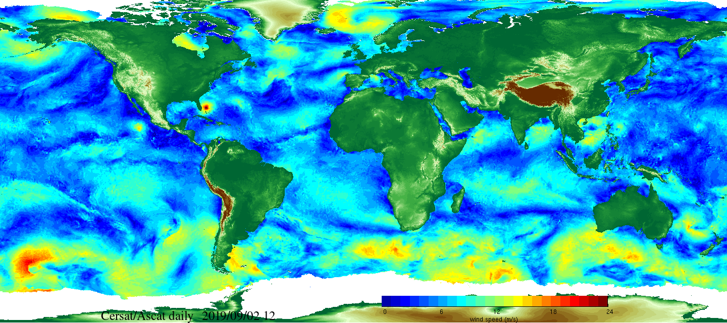
Daily and monthly surface wind analyses are determined as gridded wind products over global oceans, with regular spatial resolution of 0.25° in latitude and longitude. They are estimated from scatterometer wind retrievals (L2b data). According to the scatterometer sampling scheme, the objective method allowing the determination of regular in space surface wind fields uses remotely sensed observations as well as ECMWF analyses. The calculation of daily estimates uses ascending as well as descending available and valid retrievals. The objective method aims to provide daily-averaged gridded wind speed, zonal component, meridional component, wind stress and the corresponding components at global scale. The error associated to each parameter, related to the sampling impact and wind space and time variability, is provided too. Monthly wind analyses are calculated from daily estimates.
-

A final aggregated vulnerability index was obtained by combining all the partial indices belonging to each of the five vectors with V4 scores multiplied by −1 since Vector 4 indicators are of “resilience” rather than of “vulnerability”. Figures 6a and 6b show respectively map and cartogram of the geographical distribution obtained for this vector. As can be seen, except for most of Ireland, the Atlantic European coast ap- pears in redish colours corresponding to higher values of vulnerability.