 Metadata catalogue
Oceanic Core Complex
Type of resources
Available actions
Topics
Keywords
Contact for the resource
Provided by
Years
Formats
-
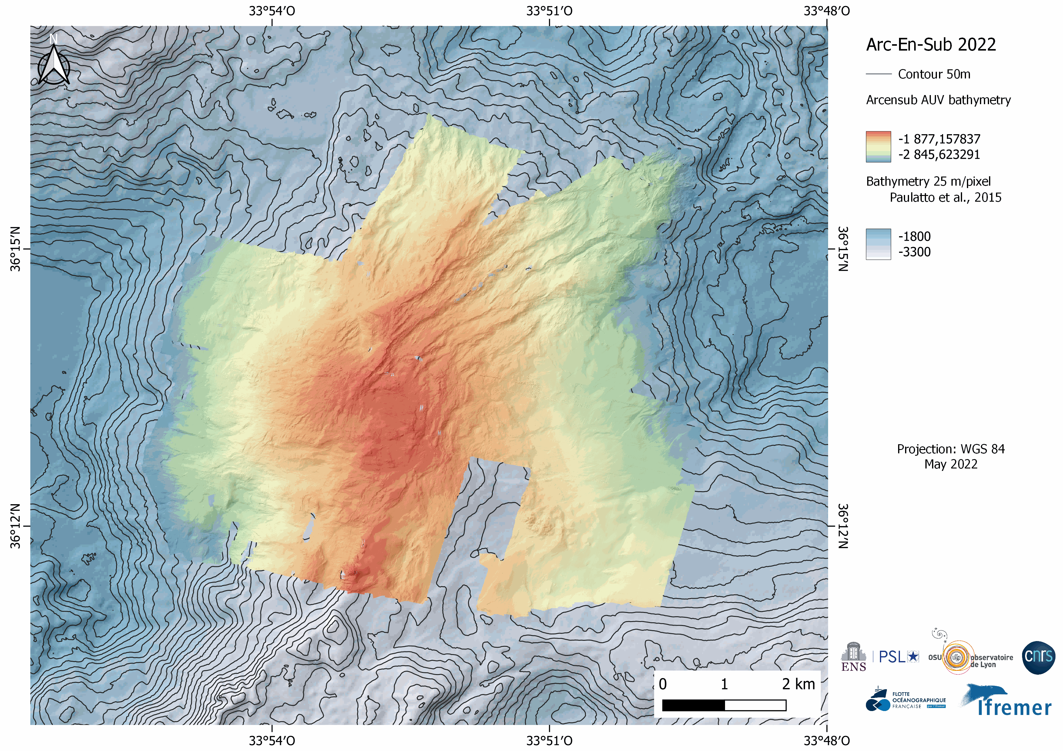
Near-bottom multibeam bathymetry and acoustic backscatter acquired at the Rainbow Massif (Mid-Atlantic Ridge). High-resolution bathymetry data (2 m/pixel) were acquired by the autonomous underwater vehicle (AUV) IdefX, deployed during the ARC-EN-SUB (https://doi.org/10.17600/18000663) cruise in May 2022. The dataset consists of grids for each individual AUV dive, as well as a global grid merging the ten completed dives. This global grid was obtained by manually shifting and combining original bathymetric grids of each dive using other datasets (primarily shipboard bathymetry from Paulatto et al. [2015]) for geographical reference. The combined grid shows the inter-dive shift artefacts, absent in the individual dive grids. Elevation grids are provided for each AUV dive without interpolation (fillgap 0), with medium (fillgap 3) and high (fillgap 15) interpolation.Acoustic backscatter grids are edited without interpolation (fillgap 0). All grids are provided in NETCDF GMT .grd format, and with two associated GEOTIFFS with the bathymetry DEM, the acoustic backscatter, and the hillshade (illumination) file. All grids are given in WGS84 (WGS 84 - WGS84 - EPSG:4326), in projection Mercator.
-
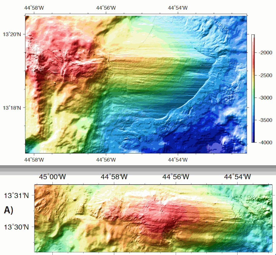
ODEMAR AUV Abyss (GEOMAR) + shipboard Pourquoi Pas? multibeam bathymetry - 13deg20minN Oceanic Core Complex, Mid Atlantic Ridge Microbathymetry acquired with AUV REMOS 6000 with a SeaBat RESON 7125 multibeam system. Bathymetry data gridded at 2 m (GMT grdfile) - one grid for 13deg20'N Oceanic Core Complex, and one grid for 13deg30'N Oceanic Core Complex - DM_OCC1320_AUV_SHI.grd: Title: ODM_OCC1320_AUV2.grd - ODM_OCC1320_AUV_SHI.grd: Command: grdmath ODM_OCC1320_AUV2.grd ODM_OCC1320_SHI2.grd AND = ODM_OCC1320_AUV_SHI.grd - ODM_OCC1320_AUV_SHI.grd: Remark: - ODM_OCC1320_AUV_SHI.grd: Gridline node registration used [Cartesian grid] - ODM_OCC1320_AUV_SHI.grd: Grid file format: nf = GMT netCDF format (32-bit float), COARDS, CF-1.5 - ODM_OCC1320_AUV_SHI.grd: x_min: -44.97115 x_max: -44.86795 x_inc: 1.7947826087e-05 name: x nx: 5751 - ODM_OCC1320_AUV_SHI.grd: y_min: 13.27915 y_max: 13.34155 y_inc: 1.79361885599e-05 name: y ny: 3480 - ODM_OCC1320_AUV_SHI.grd: z_min: -3924.5378418 z_max: -1905.49023438 name: z - ODM_OCC1320_AUV_SHI.grd: scale_factor: 1 add_offset: 0 - ODM_OCC1320_AUV_SHI.grd: format: classic - ODM_OCC1330_AUV_SHI.grd: Command: grdmath ODM_OCC1330_AUV2.grd ODM_OCC1330_SHI2.grd AND = ODM_OCC1330_AUV_SHI.grd - ODM_OCC1330_AUV_SHI.grd: Remark: - ODM_OCC1330_AUV_SHI.grd: Gridline node registration used [Cartesian grid] - ODM_OCC1330_AUV_SHI.grd: Grid file format: nf = GMT netCDF format (32-bit float), COARDS, CF-1.5 - ODM_OCC1330_AUV_SHI.grd: x_min: -45.00965 x_max: -44.88125 x_inc: 1.79454926625e-05 name: x nx: 7156 - ODM_OCC1330_AUV_SHI.grd: y_min: 13.48665 y_max: 13.52225 y_inc: 1.79254783484e-05 name: y ny: 1987 - ODM_OCC1330_AUV_SHI.grd: z_min: -3244.60083008 z_max: -2087.49829102 name: z - ODM_OCC1330_AUV_SHI.grd: scale_factor: 1 add_offset: 0 - ODM_OCC1330_AUV_SHI.grd: format: classic
-
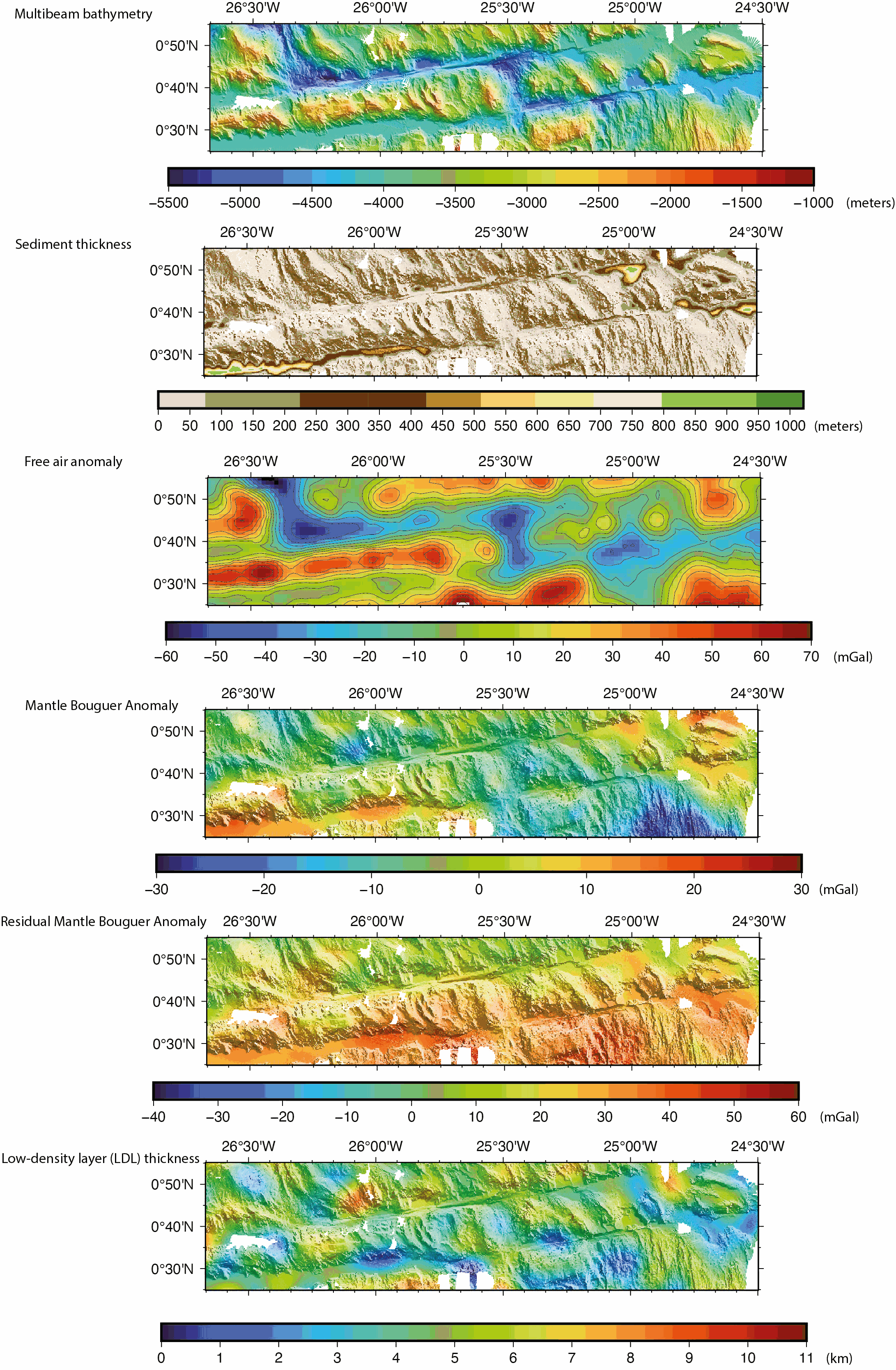
Gridded shipboard multibeam bathymetry and gravity datasets acquired during the COLMEIA cruise (2013). Gridded sediment thickness derived from seismic data. Gridded crustal thickness computed from gravity. The gridded datasets cover the South intra-transform segment of the St. Paul transform fault system. Grids created with the GMT software. Grid details as follows: Bathymetry: Grid file format: nf = GMT netCDF format (32-bit float), CF-1.7 x_min: -26.6678081446 x_max: -24.4991923884 x_inc: 0.000898349526186 name: longitude n_columns: 2415 y_min: 0.416125587833 y_max: 0.917145899441 y_inc: 0.000904368793517 name: latitude n_rows: 555 Sediment thickness: Grid file format: nf = GMT netCDF format (32-bit float), CF-1.7 x_min: -26.6697086826 x_max: -24.4984586826 x_inc: 0.00225 name: longitude n_columns: 966 y_min: 0.4154644221 y_max: 0.9194644221 y_inc: 0.00225 name: latitude n_rows: 225 Free air anomaly (merged shipboard and satellite data): Grid file format: nf = GMT netCDF format (32-bit float), CF-1.7 x_min: -26.6666666667 x_max: -24.5 x_inc: 0.0166666666667 (1 min) name: longitude n_columns: 131 y_min: 0.416666666667 y_max: 0.916666666667 y_inc: 0.0166666666667 (1 min) name: latitude n_rows: 31 Gravity anomalies (Mantle Bouguer, Residual Mantle Bouguer): Grid file format: nf = GMT netCDF format (32-bit float), CF-1.7 x_min: -26.6666666667 x_max: -24.5 x_inc: 0.00333333333333 (12 sec) name: longitude n_columns: 651 y_min: 0.416666666667 y_max: 0.916666666667 y_inc: 0.00333333333333 (12 sec) name: latitude n_rows: 151 Crustal thickness derived from the gravity anomalies: Grid file format: nf = GMT netCDF format (32-bit float), CF-1.7 x_min: -26.6666666667 x_max: -24.5 x_inc: 0.00333333333333 (12 sec) name: longitude n_columns: 651 y_min: 0.416666666667 y_max: 0.916666666667 y_inc: 0.00333333333333 (12 sec) name: latitude n_rows: 151