 Metadata catalogue
Observational data
Type of resources
Available actions
Topics
Keywords
Contact for the resource
Provided by
Years
Formats
-
During the SARDINIA experiment, CHIRP profiles, bathymetry data, three coincident MCS reflection and wide-angle seismic profiles, and one single MCS reflection profile were collected on the West Sardinia margin. The MCS reflection data was acquired using a 4.5 km 360-trace digital streamer and a tuned airgun array of 8260 cubic inches, which was towed at a depth of 18-28 m. A total of 48 ocean bottom seismometers/hydrophones (OBS/OBH) from Ifremer, University of Brest, and Geomar Kiel were deployed on the West Sardinia margin, spaced every 7 nmi (~13 km). In five locations, three OBS were deployed at the same place to ensure the collection of data. The airgun array consists of 16 airguns ranging from 100 cubic inch G-guns to 16 L Bolt airguns, with main frequencies centered around 10-15 Hz. The airguns were tuned to the first bubble, to enhance low frequencies and ensure deep penetration. The shot interval was 60 s at an average speed of 5 knots, which translates to a trace spacing of about 140-150 m. The sample rate was 8 ms for the micrOBS, 5 ms for the Geomar, and 4 ms for the OldOBS. A total of 3573 shots (profile GH: 1130, profile G2H2: 1214) were fired by the air gun array. Profiles GH and G2H2, which are 160 and 200 km long transects, respectively cross the West Sardinia margin from the continental shelf to the “atypical” oceanic crust. Twenty-one ocean bottom seismometers (OBS) were deployed on the G2H2 profile, whereas sixteen were deployed on the GH profile. Additionally, the shots on this profile were recorded by eight land seismic stations (OSIRIS stations from the University of Brest and Geosciences Azur) that extended the marine profile ~150 km onshore. For the two profiles only 33 instruments were used in the wide-angle modeling, since four instruments (OBSS06, 18a, 30a, and 30c) did not record properly. We propose here the velocity models (v.in files) of the 2 main profiles located on the West sardinian margin, Profile K7L2, located on the shelf and parallel to the margin, is not presented since most of the deep arrivals are masked by the presence of sea-bottom multiples, preventing an accurate wide-angle model.
-
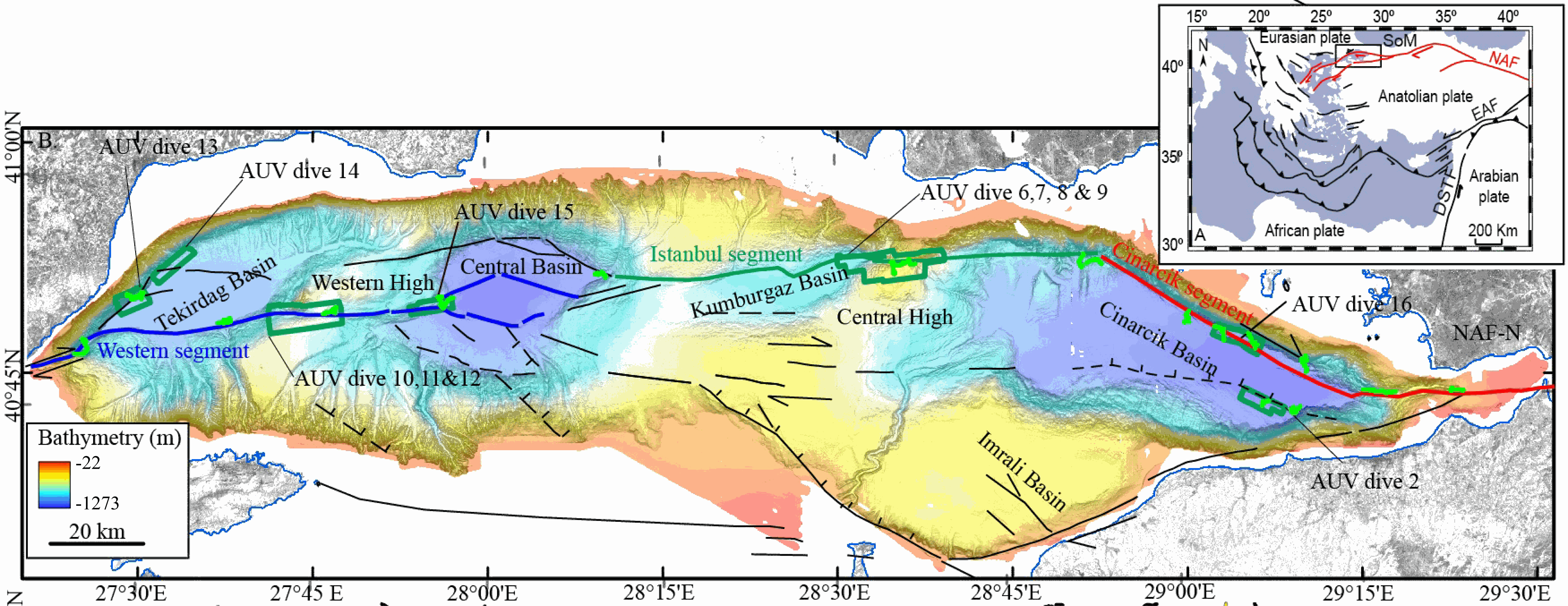
This data set contains processed multibeam sounder data from 12 dives of AsterX AUV performed on active faults scarps of the North Anatolian Fault system in the Sea of Marmara during the Marmesonet cruise (2009). The AUV carried a SIMRAD EM2000 multibeam echosounder, operating at 200 kHz, and surveyed at 50 to 70 m altitude, allowing a swath width of 150-200 m. Digital Elevation Models (DEM, in meters below sealevel) and seafloor backscatter intensity mosaics (relative amplitude in dB) are provided for 7 zones: Tekirdağ Basin W (dive 13), Tekirdağ Basin NW (dive 14), Western High (dives 10, 11 and 12), Western High E (dive 15), Central High (dive 6,7,8 and 9), Çınarcık Basin N (dive 16), Çınarcık Basin S (dive 2) (see figure). The horizontal resolution and grid pixel size of the DEM is 2 m. That of the backscatter intensity image is 1 m. Two versions of the DEM are provided. Version 1 is consistent with the backscatter image. Version 2 was updated applying a Fofonoff correction to the depths and relocating part of the AUV multibeam sounding points to fit EM302 shipborne multibeam maps. Version 2 depths and absolute positions are more accurate (10 m in the WGS-84 reference frame), but Version 1 will give better results if the backscatter image is applied as a texture or shading on the DEM. DEM and Backscatter raster files are provided in GeoTIFF format (readable with ArcGis 10.3 and QGIS 3) and use projected cartesian coordinates. They were converted from CARAIBES (Ifremer bathymetry and imagery processing software) output raster files with QGIS using GDAL translator. The Coordinate Reference System is a world Mercator projection based on WGS-84 datum, using meter units and a standard parallel at N40° latitude (latitude of preserved scale) {proj4: +proj=merc +lon_0=0 +lat_ts=+40 +x_0=0 +y_0=0 +datum=WGS84 +units=m +no_defs}. For GIS skeptics, one possible way to use these grids with Generic Mapping Tools is to perform a reverse projection back to geographic coordinates. Assuming the default PROJ_ELLIPSOID is properly set to WGS-84, the reverse projection can be applied (using gmt version 5) with the following command line: gmt grdproject AUV_XXX.tif=gd -GAUV_XXX.grd -Jm0/40/1:1 -F -C -I -V
-
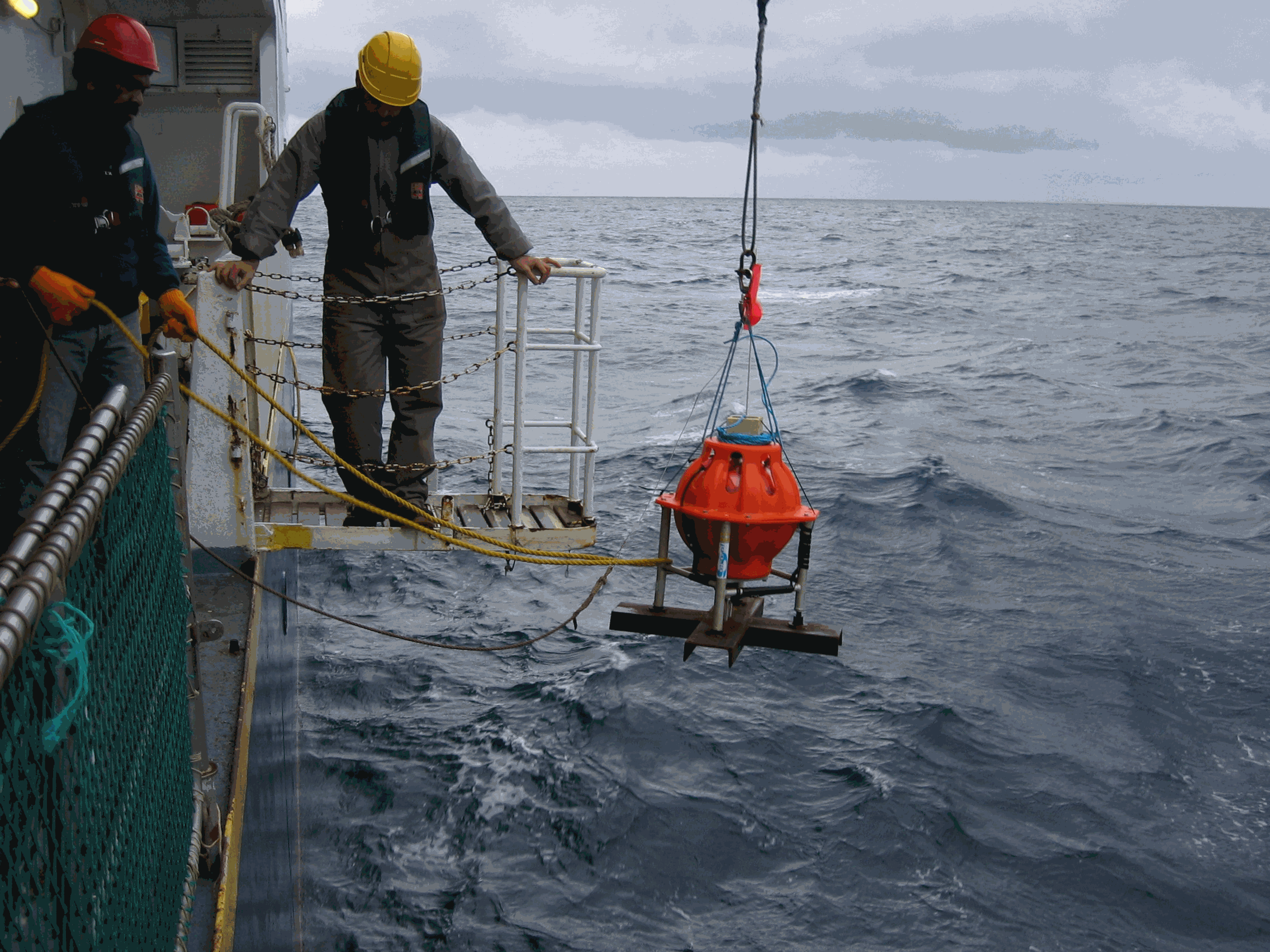
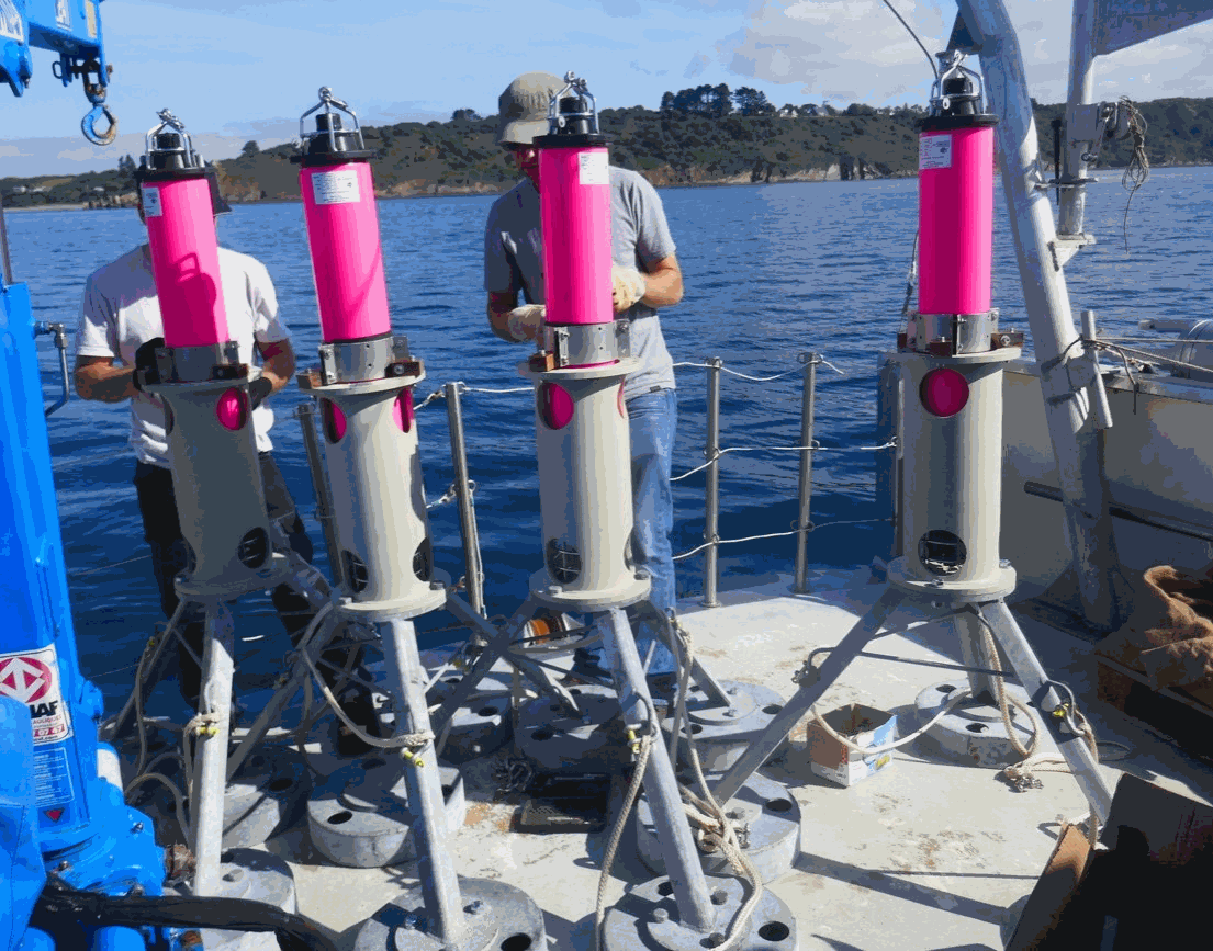
This dataset was recorded from 15th of April to 31st of July , 2011, by 10 autonomous, short-period (4.5 Hz) OBSs from Ifremer.
-
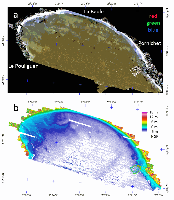
The LiDAR used is the Titan DW 600 from Teledyne Optech of the “Platform topo-bathymétrique aéroportée Nantes-Rennes”. Both 532-nm and 1064-nm LiDAR swath were acquired 6th and 7th of October 2017, at 400 m above ground with a FOV of 28° giving strip image width of 199.5 m with a nominal footprint of 0.49 m along-track and 0.29 m cross-track. A mirror compensation and a sidelap of 30% was used to prevent empty space between strips. The effective incident angle range was from 4 to 20°. The aircraft speed being 201.7 km/h the down track footprint rise up to 0.98 m on sideway what justify a final spatial resolution of 1 m. The laser pulse frequency was set to 50 kHz (100 kHz locally) giving an overall mean point density of 3.52 points/m². The full-waveform (FWF) was recorded only in 532-nm with a maximum length of 60 m, at 1 GHz frequency, resulting in a vertical resolution of 0.15 m. The Optech LiDAR Mapping Suite (LMS) combines a Global Positioning System (GPS) and Inertial Measurement Unit (IMU) to provide a georeferenced point cloud and associated FWF with strip optimization. To compute the complete point cloud, LMS uses an analogous approach to photogrammetric block adjustment. On overlap areas between each flight line, planes (typically roofs in land) are extracted and used in a least squares adjustment model provided by LMS. The trajectory accuracy provided by GEOFIT Company was better than 0.15 m in planimetry and 0.08 m on elevation. The set of data is stored in a zip file composed of the following image files associated with ENVI headers which are text files describing the image format. - LaBaule_2017106-7-orthophoto: contain the mosaic of RGB image acquired with the camera associated to the LiDAR. - LaBaule_2017106-7_536nm_raytracing-incident_angles_2m: contains the effective incident angle of each pixel retained in the mosaic with a pixel FOV of 0.3° and with a tilling of image strips in the top of each other from the North to the South. - LaBaule_2017106-7_1064nm_raytracing_discrete_echo_ranges_2m: contains the elevation of the water surface of each pixel. - LaBaule_2017106-7_536nm_raytracing_FWF_2m: contains the row FWF projected on the image plane at 0 m NGF with an offset of 30 m for easy spectral processing of the FWF (true range are stored in band names). - LaBaule_2017106-7_536nm_raytracing_FWF_2m_intensity_stats: contains the basic statistics of the FWF intensities. - LaBaule_2017106-7_536nm_raytracing_FWF_2m_range_stats: contains the min, max and thickness of the FWF ranges. - LaBaule_2017106-7_536nm_raytracing_FWF_2m_row_results: contains the row results of water surface and method 1 (dddNCFWF echoes) and method 2 (NCFWFT-1 bottoms) bathymetries as defined in https://doi.org/10.3390/rs11020117. - LaBaule_2017106-7_536nm_raytracing_FWF_4m_final_bathymetry: contains the final (cleaned NCFWFT-1 bottoms) bathymetry. The same data were acquired the 11th of August 2018 during a low tide with the same settings without RGB camera but with a new FWF recorder giving a lot less noisy signal allowing a constant spatial resolution of 1 m. The set of data is stored in a zip file composed of the following image files associated with ENVI headers which are text files describing the image format. - LaBaule_20180811_536nm_raytracing-incident_angles_1m: contains now 3 channels for the effective incident angle, the strip number and the GPS time. - LaBaule_20180811_1064nm_raytracing_discrete_echo_ranges_1m: contains the elevation of the water surface and all echoes above it in each pixel. - LaBaule_20180811_536nm_raytracing_FWF_1m: contains the row FWF projected on the image plane at 0 m NGF with an offset of 30 m for easy spectral processing of the FWF (true range are stored in band names). - LaBaule_20180811_536nm_raytracing_FWF_1m_intensity_stats: contains the basic statistics of the FWF intensities. - LaBaule_20180811_536nm_raytracing_FWF_1m_range_stats: contains the min, max and thickness of the FWF ranges. - LaBaule_20180811_536nm_raytracing_FWF_1m_row_results: contains the row results of water surface and method 1 (dddNCFWF echoes) and method 2 (NCFWFT-1 bottoms) bathymetries as defined in https://doi.org/10.3390/rs11020117. - LaBaule_20180811_536nm_raytracing_FWF_1m_final_bathymetry: contains the best of dddNCFWF echoes and NCFWFT-1 bottoms simply presented with the application of a 5x5 median filter. -
-

During the SARDINIA experiment, three coincident MCS reflection and wide-angle seismic profiles, sub-bottom high resolution (CHIRP) profiles, and bathymetry data were collected on the Gulf of Lion margin. The seismic reflection data were acquired using a 4.5 km, 360 trace digital streamer and a tuned airgun array of 8260 in3, towed at a depth of 18-28 m. A total of 57 ocean bottom seismometer/ hydrophones (OBS/OBH) from Ifremer, University of Brest, and Geomar Kiel were deployed in the Gulf of Lion, spaced every 7 Nm (~13 km). The airgun array consists of 16 airguns ranging from 100 in3 G-guns to 16 L Bolt airguns, with main frequencies centered around 10-15 Hz. The airguns were tuned to the first bubble to enhance low frequencies and ensure a good penetration. The shot interval was 60 s at an average speed of 5 knots, which translates to a trace spacing of about 140-150 m. The sample rate was 8 ms for the micrOBS, 5 ms for the Geomar’s OBS and 4 ms for the OldOBS. A total of 6160 shots (profile AB: 3032, profile CD: 1730, profile EF: 1398) were fired by the air gun array. Profile AB crosses the Gulf of Lion’s margin, parallel to the ECORS profile, from the continental shelf to Domain III. Twenty-five ocean bottom seismometers (OBS) were deployed on this profile, of 467 km in length. Twenty-two instruments were used in the wide-angle modelling, since three instruments (OBS 45, 49 and 52) did not properly record. The shots on this profile were additionally recorded by 9 land seismic stations (OSIRIS stations from the University of Brest and Geosciences Azur) that have extended the marine profile ~120 km onshore. Profiles CD and EF are 250 and 210 km long transects parallel to the margin. Profile CD was acquired using 19 OBS of which 18 yielded usable data. Profile EF was acquired using 15 OBS of which 12 yielded usable data. These two profiles cross the profile AB, respectivelyat OBS 26 and OBS 8.
-
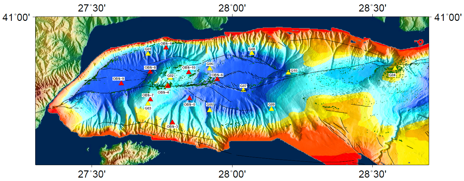
This dataset was recorded from September 19th to 14th of November , 2014, by 9 autonomous, short-period (4.5 Hz) from Ifremer.
-
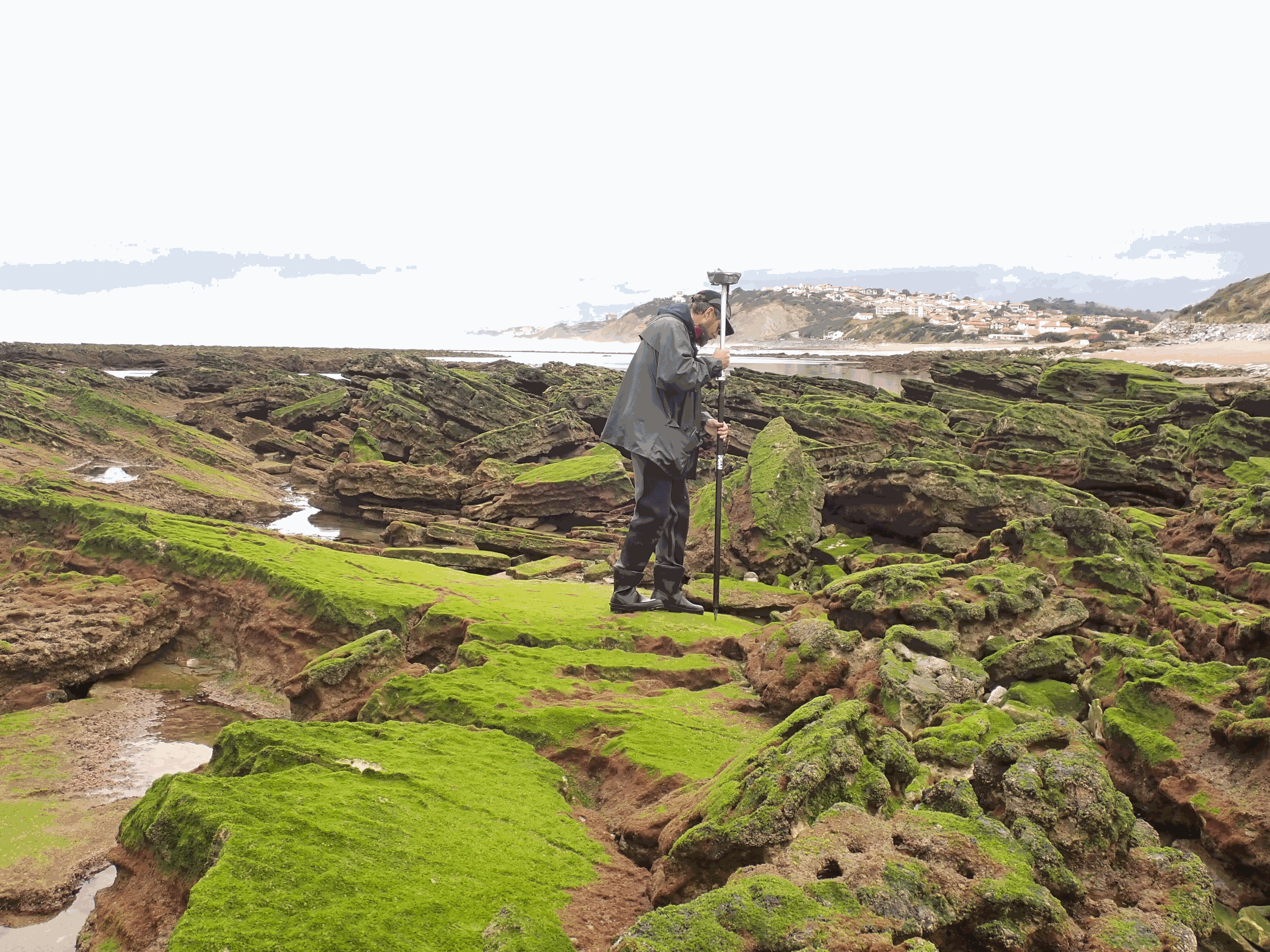
The present dataset is based on a nine site study of fine seabed topography in intertidal zones. Four coral sites (Maupiti A, B and C and Niau islands) and five rocky sites (Ars en Ré, Socoa, Parlementia A and B and Banneg island) have been explored. The data has been gathered using on-foot GNSS RTK for all sites (Trimble R8/R8S and Leica sytems) except Banneg island, where aerial Lidar data from Litto3D program has been used. The horizontal resolution varies between 3.8 and 12cm allowing to describe a wide range of spatial scales (generally over 3 spectral decades). The data has been processed to explore the statistical and spectral metrics which can be used to characterize the architectural complexity of seabeds.
-
In the framework of the ERC FOCUS project, the Geosciences Ocean Laboratory (LGO) organized, from July 22 to 26, 2019, an experiment of seafloor geodesy in the Bay of Brest, entitled Geodesea-2019. The aim was to test acoustic beacons acquired for the FOCUS project and to test experimental protocols for seafloor positioning. The experiment was carried out from the Albert Lucas research station-vessel. The experiment was conducted in collaboration with the Laboratoire Environnement et Sociétés (LIENSs) from la Rochelle and the iXBlue company, in Brest. Relative acoustic ranging was carried out during four days, each beacon ranging the other ones at a regular time interval, while acquiring auxiliary data (temperature, pressure, sound-speed) to be able to convert travel-times into distances. Absolute positioning of the beacons on the seafloor was also carried out using a small Unmanned Surface Vehicle (USV) on which a compact GNSS/Acoustic system was mounted, combining an Ultra Short Baseline (USBL), an inertial system (INS) and a GNSS receiver.
-
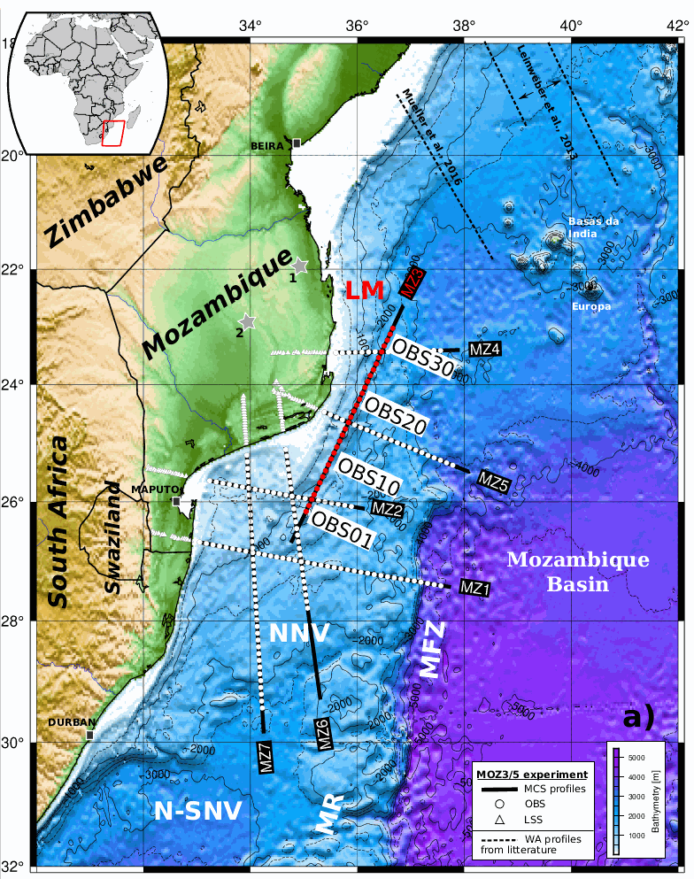
Coincident wide-angle and multi-channel seismic data acquired within the scope of the PAMELA Moz3-5 project allow to reconsider the formation mechanism of East-African margins offshore southern Mozambique. This study most specifically focuses on the sedimentary and deep crustal architecture of the Limpopo margin (LM) that fringes the eastern edge of the Mozambique’s Coastal Plain (MCP) and its offshore southern prolongation the North Natal Valley (NNV). It relies primarily on the MZ3 profile that runs obliquely from the northeastern NNV towards the Mozambique basin (MB) with additional inputs from a tectono-stratigraphy analysis of industrial onshore-offshore seismic lines and nearby or crossing velocity models from companion studies. Over its entire N-S extension the LM appears segmented in (1) a western domain that shows the progressive eastward crustal thinning and termination of the MCP/NNV continental crust and its overlying pre-Neocomien volcano-sedimentary basement; and (2) a central corridor of anomalous crust bounded to the east by the Mozambique fracture zone (MFZ) and the oceanic crust of the MB. A prominent basement high marks the boundary between these two domains. Its development was most probably controlled by a steep and deeply rooted fault, i.e. the Limpopo fault. We infer that strike-slip or slightly trans-tensional rifting occurred along the LM and was accommodated along this Limpopo fault. At depth we propose that ductile shearing was responsible for the thinning of the continental crust and an oceanward flow of lower crustal material. This process was accompanied by intense magmatism that extruded to form the volcanic basement and gave to the corridor its peculiar structure and mixed nature. The whole region remained at a relative high level during the rifting period and a shallow marine environment dominated the pre-Neocomien period during the early phase of continent-ocean interaction. It is only some times after break-up in the MB and the initiation of the MFZ that decoupling occurred between the MCP/NNV and the corridor allowing for the latter to subside and being covered by deep marine sediments. A scenario for the early evolution and formation of the LM is proposed taking into account both recent kinematic and geological constraints. It implies that no or little changes in extensional direction occurred between the intra-continental rifting and subsequent phase of continent-ocean interaction.
-
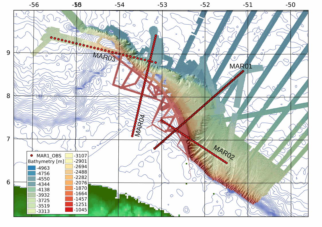
This archive includes wide-angle seismic data from profiles 1, 2, 3 and 2 of the MARGATS cruise offshore French Guyana and Surinam including navigation files. The objective is more precisely to characterize the crustal structure and evolution of marginal plateaux, sub-marine reliefs that are associated to 30 % of the transform margins in the world. These reliefs are systematically observed at the junction of different ages in relay zones between divergent and transform segments. Their building remains enigmatic although they represent reliefs established in geodynamical nubs that are keys ton understand the localisation of transform margins. This project MARGATS intend to image the deep structure of the marginal plateau (wide angle seismic and multichannel seismic MCS). The experimental site proposed is the Demerara plateau offshore French Guyana and Surinam and located at the junction between Central Atlantic locally opened in a divergent mode and Equatorial Atlantic opened mainly in transform mode in the area. Hence, this plateau has recorded at its different borders the divergent opening of the central Atlantic and the tranform opening of the Equatorial Atlantic. It may be this situation itself that leads to the formation of the plateau, but it requires to precisely constraint its deep internal structure. Finally the Demerara plateau is one of the more studied with petroleum seismic data and high resolution seismic data. It is then one of the ideal place to conduct a high resolution wide-angle deep seismic survey.