 Metadata catalogue
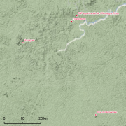
Nouragues
Type of resources
Available actions
Topics
Keywords
Contact for the resource
Provided by
Years
Formats
Representation types
Update frequencies
status
Scale
Resolution
-

Subset of the image that covers the experimental site Nouragues in French Guiana.
-

Subset of the Pléiades image that covers the experimental station Nouragues in French Guiana.
-

The Nouragues forestry experimental site is located the Nouragues experimental station in French Guiana (other experimental sites than Nouragues plots are established in Nouragues station). This experimental site is composed by several plots not contiguous, some of them are divided into smaller plots (1ha). For each plot, the following information is recorded for all trees and lianas with DBH ≥ 10cm : 1. location of individuals inside the plot, 2. botanical identification (when it is possible), 3. diameter at breast height, or 30 cm above last aerial root, last buttress or last irregularity, 4. total height of tree (subsample). Since 2012, on Grand Plateau and Petit Plateau : 1. coefficient of light exposure 2. coefficient of infestation by lianas in tree crown.
-
Guyadiv is a network of permanent forest plots set accross French Guiana. The Guyadiv plots in Nouragues cover 3ha included in the Parare permanent plots which are managed by CNRS. 18916 trees are being monitored. 8 campaigns of inventories were conducted in 1985, 1993, 1995, 2000, 2004, 2007, 2008, 2010. The bounding box of this metadata sheet represents only the extension of Parare plots.
-

Guyafor is a network of permanent forest plots installed in French Guiana. The Guyafor Database compiles coordinates of the 11 sites (Paracou, Bafog, Organabo, Risquetout, Montagne Tortue, Saut Lavilette, Acarouany (Javouhey), Montagne Plomb, Tibourou, Nouragues, Laussat) and their subdivisions of the guianese permanent plots network. Each site contains georeferenced trees, botanically identified and regularly measured (diameter) for varying periods, depending to the site. To have more informations about each site, please refer to the attached metadata sheets
-

The project Bridging Information on Tree Diversity in French Guiana, and a Test of Ecological Theories (BRIDGE) brings together researchers from nine different European research groups in tropical ecology, and seeks to improve our knowledge on the various dimensions of tree biological diversity in French Guiana. The project includes ten one-hectare old-growth forest tree plots across a range of geology and rainfall in French Guiana. The amount of niche conservatism across an ecologically relevant set of functional, reproductive, and defense traits have been measured in the field.
-

Habitats inventories have been installed over the years in French Guiana using a standardized multi-scale protocol. In each site, we established two to four transects, about 2.5 to 3-km long in different directions to optimally sample the local environmental variability. Each 20-m width transect was divided into 100 m segments so that the basic sampling units are 0.2-ha plots. All the plots were geo-referenced using a Garmin 76CSx GPS receiver and delineated in the field using a Vertex laser clinometer. In each plot, all trees (including palm-trees) greater than 20 cm diameter at breast height (DBH) or above the buttresses were identified by local forest-plotters from ONF. They referred to a vernacular nomenclature whose names correspond either to a botanical species, genus or family. Tested against true botanical data on 4279 trees (Guitet et al., 2014), this nomenclature proved 83% effective accuracy at the family level and 74% at the level of the most precise botanical equivalent of our vernacular names (i.e. the species, genus or family level depending on the precision reached by forest-plotters). Soil samples were also collected in 490 selected plots representative of the different topographical positions along each transect. Chemical and textural analyses are available. Plants of the under-storey have been collected by IRD in several 5m x 5m sub-plots on different sites : Kourouaï, Piton Baron, Aïmara, Saut Parasol, Mont Itoupé, Waki, Toponowini, Bagote, Haute Beiman, Roche Koutou, Regina. Standardized line transects surveys were conducted by ONCFS in 25 sites on the same transects in order to record large mammals and terrestrial birds. Transects were walked at less than 1 kmh-1 speed every morning (7:00-11:00) and afternoon (14:30-18:00) by only one observer by trail, systematically alternating transects on consecutive days to avoid observer bias. All encounters of focus species and their localization on the trail were systematically recorded and the perpendicular distance between animal and transect was measured with a laser ranger finder to the nearest meter.