 Metadata catalogue
Nouméa
Type of resources
Available actions
Topics
INSPIRE themes
Keywords
Contact for the resource
Provided by
Years
Formats
Representation types
Update frequencies
status
Scale
Resolution
-
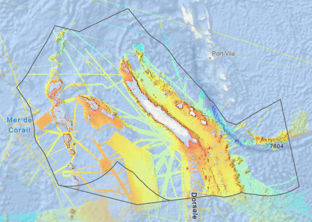
Bathymétrie du Parc Naturel de la Mer de Corail, en Nouvelle-Calédonie (synthèse créée en 2022), au pas de 100 mètres. Ce Modèle Numérique de Terrain est une compilation de données bathymétriques acquises par sondeur multifaisceaux. L'étendue de la version disponible correspond aux délimitations du Parc Naturel de la Mer de Corail (PNMC). Référence verticale : Niveau observé des mers Rapport de traitement : Karthikeyan Vishnu, Collot Julien, Etienne Samuel, Loubrieu Benoit, Patriat Martin, Vende-Leclerc Myriam, Tanguy Nina, Pertuisot Cecile, Soulard Benoit (2022). Base de données de sondeurs multifaisceaux et modèles bathymétriques de la Nouvelle-Calédonie –hors lagon. SGNC-2022(12). https://doi.org/10.13155/91834 Description des campagnes : - PELLETIER Bernard, LAGABRIELLE Yves (2000) ALAUFI cruise, RV L'Atalante, https://doi.org/10.17600/10030 - HILL Peter (1999) AUSTREA1 cruise, RV L'Atalante, https://doi.org/10.17600/99010140 - WOOD Ray (2000) AUSTREA3.RESOLUTION.RIDGE cruise, RV L'Atalante, https://doi.org/10.17600/10020 - ANDREFOUET Serge (2021) BICHECALIS cruise, RV Alis, https://doi.org/10.17600/18001732 - MAES Christophe (2012) BIFURCATION cruise, RV Alis, https://doi.org/10.17600/12100100 - LEVI Claude (1985) BIOCAL cruise, RV Jean Charcot, https://doi.org/10.17600/85002911 - CABIOCH Guy (2001) BOISALIS 1 cruise, RV Alis, https://doi.org/10.17600/1100080 - PAYRI Claude (2004) BSMS - 1 cruise, RV Alis, https://doi.org/10.17600/4100070 - LE ROY Pascal, JORRY Stéphan (2013) CALICO cruise, RV Alis, https://doi.org/10.17600/13100080 - EISSEN Jean-Philippe (1996) CALVA cruise, RV L'Atalante, https://doi.org/10.17600/96010050 - MAGALON Hélène (2015) CHEST cruise, RV Alis, https://doi.org/10.17600/15004500 - HOURDEZ Stéphane, JOLLIVET Didier (2019) CHUBACARC cruise, RV L'Atalante, https://doi.org/10.17600/18001111 - PAYRI Claude (2008) CORALCAL-2 cruise, RV Alis, https://doi.org/10.17600/8100050 - PAYRI Claude (2015) CORALCAL-5 cruise, RV Alis, https://doi.org/10.17600/15004300 - LE BORGNE Robert (1996) EBENE cruise, RV L'Atalante, https://doi.org/10.17600/96010090 - RICHER DE FORGES Bertrand (2005) EBISCO cruise, RV Alis, https://doi.org/10.17600/5100080 - PELLETIER Bernard (2001) ESS_SMF cruise, RV Alis, https://doi.org/10.17600/18002440 - SAMADI Sarah, CORBARI Laure (2011) EXBODI cruise, RV Alis, https://doi.org/10.17600/11100080 - MAUFFRET Alain, SYMONDS Phil (1999) FAUST2 cruise, RV L'Atalante, https://doi.org/10.17600/99010130 - VIGLIOLA Laurent (2021) FISHCODE cruise, RV Alis, https://doi.org/10.17600/18001636 - LE BORGNE Robert (1994) FLUPAC cruise, RV L'Atalante, https://doi.org/10.17600/94010080 - BALLU Valérie (2013) GEODEVA6_NC2013 cruise, RV Alis, https://doi.org/10.17600/13100120 - AUZENDE Jean-Marie (1987) KAIYO 87/1 cruise https://campagnes.flotteoceanographique.fr - AUZENDE Jean-Marie (1988) KAIYO 88/1 cruise https://campagnes.flotteoceanographique.fr - PUILLANDRE Nicolas, SAMADI Sarah (2016) KANACONO cruise, RV Alis, https://doi.org/10.17600/16003900 - SAMADI Sarah, HOURDEZ Stéphane (2017) KANADEEP 1 cruise, RV Alis, https://doi.org/10.17600/17003800 - SAMADI Sarah, OLU Karine (2019) KANADEEP 2 cruise, RV L'Atalante, https://doi.org/10.17600/18000883 - OLU Karine, ALLAIN Valérie (2020) KANARECUP cruise, RV Alis, https://doi.org/10.17600/18001103 - LALLEMAND Serge (1996) KAONOU cruise, RV L'Atalante, https://doi.org/10.17600/96010140 - GARRIGUE Claire (2017) MARACAS 3 cruise, RV Alis, https://doi.org/10.17600/17003700 - BORSA Philippe (2012) MOMALIS cruise, RV Alis, https://doi.org/10.17600/12100050 - DANIEL Jacques (1987) MULTIPSO cruise, RV Jean Charcot, https://doi.org/10.17600/87001411 - LAGABRIELLE Yves, RUELLAN Etienne, TANAHASHI Manabu (1994) NOFI cruise, RV L'Atalante, https://doi.org/10.17600/94010070 - RICHER DE FORGES Bertrand (2003) NORFOLK 2 cruise, RV Alis, https://doi.org/10.17600/3100030 - ROEST Walter, LOUBRIEU Benoit (2004) NOUCAPLAC cruise (mission NOUCAPLAC/1), RV L'Atalante, https://doi.org/10.17600/18000825 - ROEST Walter, LOUBRIEU Benoit (2004) NOUCAPLAC cruise (mission NOUCAPLAC/2), RV L'Atalante, https://doi.org/10.17600/18000825 - GELI Louis (1996) PACANTARCTIC cruise, RV L'Atalante, https://doi.org/10.17600/96010020 - CABIOCH Guy (2002) PALEOPENTE cruise, RV Alis, https://doi.org/10.17600/2100030 - PELLETIER Bernard (1999) PAPNOU99 cruise, RV L'Atalante, https://doi.org/10.17600/99010110 - CABIOCH Guy (2003) PENTES-WALPOLE cruise, RV Alis, https://doi.org/10.17600/3100010 - EISSEN Jean-Philippe (1996) PORMEA cruise, RV L'Atalante, https://doi.org/10.17600/96010060 - BENZONI Francesca (2017) POST-BLANCO LEG1 cruise, RV Alis, https://doi.org/10.17600/17003200 - BENZONI Francesca (2017) POST-BLANCO LEG2 cruise, RV Alis, https://doi.org/10.17600/17003500 - VIGLIOLA Laurent (2014) PRISTINE 3 cruise, RV Alis, https://doi.org/10.17600/14004500 - LEMASSON Lionel (1985) PROLIGO cruise, RV Jean Charcot, https://doi.org/10.17600/85004711 - PANCHE Jean-Yves (2003) PROVINCE ILES 1 cruise, RV Alis, https://doi.org/10.17600/18003193 - PELLETIER Bernard (2003) PROVINCE ILES 2 cruise, RV Alis, https://doi.org/10.17600/18003194 - PERRIER Julien (2004) PROVINCE ILES 3 / 1 cruise, RV Alis, https://doi.org/10.17600/4100010 - PERRIER Julien (2004) PROVINCE ILES 3 / 2 cruise, RV Alis, https://doi.org/10.17600/4100020 - PELLETIER Bernard (2002) PROVINCE NORD 1 cruise, RV Alis, https://doi.org/10.17600/18002436 - PELLETIER Bernard (2003) PROVINCE NORD 2 cruise, RV Alis, https://doi.org/10.17600/18002437 - GALLOIS Francis (2003) PROVINCE NORD 3 cruise, RV Alis, https://doi.org/10.17600/18002438 - PERRIER Julien (2004) PROVINCE SUD 1 / 1 cruise, RV Alis, https://doi.org/10.17600/4100050 - PERRIER Julien (2004) PROVINCE SUD 1 / 2 cruise, RV Alis, https://doi.org/10.17600/4100080 - PERRIER Julien (2004) PROVINCE SUD 2 cruise, RV Alis, https://doi.org/10.17600/4100100 - PERRIER Julien (2004) PROVINCE SUD 3 cruise, RV Alis, https://doi.org/10.17600/4100120 - PERRIER Julien (2005) PROVINCE SUD 4 cruise, RV Alis, https://doi.org/10.17600/5100070 - VIGLIOLA Laurent, BALETAUD Florian (2020) SEAMOUNTS 2020 cruise, RV Alis, https://doi.org/10.17600/18001119 - DANIEL Jacques (1985) SEAPSO 1 cruise, RV Jean Charcot, https://doi.org/10.17600/85004911 - ETIENNE Samuel, COLLOT Julien, LE ROY Pascal (2018) SEDLAB cruise, RV Alis, https://doi.org/10.17600/18000401 - Division Plans de DMI - SHOM (2015) SHOMCAL_CHESTERFIEDS cruise, RV L'Atalante, https://doi.org/10.17600/15018400 - Division Plans de DMI - SHOM (2015) SHOMCAL_GRAND_LAGON_NORD cruise, RV L'Atalante, https://doi.org/10.17600/15018300 - Division Plans de DMI - SHOM (2015) SHOMCAL_SARCELLE cruise, RV L'Atalante, https://doi.org/10.17600/15018500 - SHOMPAC 2019 https://data.shom.fr/ - DANIEL Jacques (1993) SOPACMAPS LEG1 cruise, RV L'Atalante, https://doi.org/10.17600/93000250 - PELLETIER Bernard (1993) SOPACMAPS.LEG3 cruise, RV L'Atalante, https://doi.org/10.17600/93000252 - SAMADI Sarah (2021) SPANBIOS 2021 cruise, RV Alis, https://doi.org/10.17600/18000701 - HELLO Yann (2019) SPPIM 2019 cruise, RV L'Atalante, https://doi.org/10.17600/18000882 - COLLOT Julien, SUTHERLAND Rupert, ROEST Walter (2015) TECTA cruise, RV L'Atalante, https://doi.org/10.17600/15001300 - TR_FUTNMA cruise, RV Alis, 2011 https://campagnes.flotteoceanographique.fr/ - Opérateur IPEV (2006) TRANSIT AUCKLAND - NOUMEA cruise, RV Marion Dufresne, https://doi.org/10.17600/6200150 - MASCLE Jean (1993) TRANSNOR cruise, RV L'Atalante, https://doi.org/10.17600/93000810 - PATRIAT Martin, MORTIMER Nick (2015) VESPA cruise, RV L'Atalante, https://doi.org/10.17600/15001100 - PAUTOT Guy (1993) ZONECO1 cruise, RV L'Atalante, https://doi.org/10.17600/93000130 - LAFOY Yves (1994) ZONECO2 cruise, RV L'Atalante, https://doi.org/10.17600/94010060 - MISSEGUE François (1996) ZONECO3 cruise, RV L'Atalante, https://doi.org/10.17600/96010070 - LE SUAVE Raymond (1996) ZONECO4 cruise, RV L'Atalante, https://doi.org/10.17600/96010080 - AUZENDE Jean-Marie (1999) ZONECO5 cruise, RV L'Atalante, https://doi.org/10.17600/99010120 - LAFOY Yves (2004) ZONECO11 cruise, RV L'Atalante, https://doi.org/10.17600/4010090 - FOUCHER Jean-Paul (2006) ZONECO12 cruise, RV Marion Dufresne, https://doi.org/10.17600/6200090 - BMRG07MV http://maps.continentalshelf.org/geodas/BMRG07MV.htm - DEEP FREEZE 03 - EW0002 (WOODLARK_BASIN, 2000) https://doi.org/10.7284/901170 - HAWAIKI - IN2016_T01 https://mnf.csiro.au/en/Voyages/IN2016_T01 (ECOSAT2) - IN2019_V04 https://mnf.csiro.au/en/Voyages/IN2019_V04 (ECOSAT3) - KM0703 (2007) (SPEEDO) http://www.rvdata.us/catalog/KM0703 - KM0504 https://doi.org/10.7284/900816 - KM0701 (WESTERN PACIFIC WARM POOL, 2007) https://doi.org/10.7284/901730 - KR1605/GA-0354 https://doi.org/10.4225/25/59f7c1c232ff0 - KR17-15C / GA-0363 http://dx.doi.org/10.26186/5bf76dd8aba72 - MR0707 LEG1 / GA-2482 (2007) - SO 190 http://dx.doi.org/10.3289/ifm-geomar_rep_8_2007 - SS200405 https://www.cmar.csiro.au/data/trawler/survey_details.cfm?survey=SS200405 - SS200406 https://www.cmar.csiro.au/data/trawler/survey_details.cfm?survey=SS200406 - SS200410 https://www.cmar.csiro.au/data/trawler/survey_details.cfm?survey=SS200410 - SS200502 https://www.cmar.csiro.au/data/trawler/survey_details.cfm?survey=SS200502 - SS200608 https://www.cmar.csiro.au/data/trawler/survey_details.cfm?survey=SS200608 - SS200806 https://www.cmar.csiro.au/data/trawler/survey_details.cfm?survey=SS200806 - SS200807 https://www.cmar.csiro.au/data/trawler/survey_details.cfm?survey=SS200807 - SS2009_T02 https://www.cmar.csiro.au/data/trawler/survey_details.cfm?survey=SS2009_T02 - SS2009_V03 https://www.cmar.csiro.au/data/trawler/survey_details.cfm?survey=SS2009_V03 - SS2012_T02 https://www.cmar.csiro.au/data/trawler/survey_details.cfm?survey=SS2012_T02 - SS2012_T03 https://www.cmar.csiro.au/data/trawler/survey_details.cfm?survey=SS2012_T03 - SS2012_V06 https://www.cmar.csiro.au/data/trawler/survey_details.cfm?survey=SS2012_V06 - ST200601 https://www.cmar.csiro.au/data/trawler/survey_details.cfm?survey=ST200601 - ST200602 https://www.cmar.csiro.au/data/trawler/survey_details.cfm?survey=ST200602 - TAN0713 / Faust Capel Basins Survey / GA-2436 http://dx.doi.org/10.4225/25/562EC38653868 - TAN1410 (NOUMEA TRANSIT) - TAN2106 (2021) - WEST05MV https://doi.org/10.7284/904607 - WEST06MV https://doi.org/10.7284/904608 - WEST12MV https://doi.org/10.7284/904614
-
Plusieurs maquettes hydrodynamiques à des emprises et résolutions différentes ont été développées par l'UR LEAD (Lagons, Ecosystèmes et Aquaculture Durable en Nouvelle-Calédonie) dans le cadre du projet PRESENCE : - La grille KENU possède une emprise à l'échelle régionale de la Nouvelle-Calédonie avec une résolution de 1500 m sur 50 niveaux verticaux et une rotation de 40°. - L'emprise de la grille KAGOU est centrée sur la partie Sud de la Grand Terre (Province Sud) à une résolution de 300 m sur 50 niveaux verticaux et une rotation de 40°. - La grille KANA est axée sur la Grande Terre avec une résolution de mailles de 300 m, sur 50 niveaux verticaux et une rotation de 40°. - La maquette POE possède une emprise locale entre le lagon du Cap et le lagon de Moindou (Province Sud) avec une résolution de grille égale à 50 m sur 50 niveaux verticaux.
-
Les aires marines protégées (ou AMP) sont des espaces délimités en mer qui répondent à des objectifs de protection de la nature à long terme. La plupart des AMP permettent de concilier les enjeux de protection et le développement durable d'activités. Leurs modes de gouvernance associent le plus souvent les usagers, les élus, les experts... à la gestion de l'espace marin identifié. Le code de l'environnement (article L334-1) reconnaît différentes catégories d'aires marines protégées qui répondent chacune à des objectifs propres tout en étant complémentaires. La donnée des périmètres des AMP est tenue par l'ensemble des géomaticiens du pôle géomatique mer et littoral de l'Office français de la biodiversité.
-
The GEBCO grid is global data set of elevation values, in metres, on a 15 arc-second interval grid. It is accompanied by a Type Identifier (TID) Grid that gives information on the types of source data that the GEBCO_2024 Grid is based on. An additional 4.34 million square kilometres of bathymetric data has been added to the global grid since the last release in 2023, with 26.1% of the seabed now mapped. This is the Sixth GEBCO grid developed through the Nippon Foundation-GEBCO Seabed 2030 Project.This is a collaborative project between the Nippon Foundation of Japan and GEBCO. The aim of the project is to map the global sea floor by 2030. GEBCO's grids can be downloaded as a global file in netCDF format or for user-defined areas, through our download app, in netCDF, data GeoTiff and ESRI ASCII raster formats. The data set can also be downloaded in the form of imagery. This release of the GEBCO grid includes data from version 5.0 of the International Bathymetric Chart of the Arctic Ocean (IBCAO) . GEBCO's aim is to provide the most authoritative publicly-available bathymetry of the world's oceans. It operates under the joint auspices of the International Hydrographic Organization (IHO) and the Intergovernmental Oceanographic Commission (IOC) (of UNESCO).
-
The GEBCO_2022 Grid is a global continuous terrain model for ocean and land with a spatial resolution of 15 arc seconds. In regions outside of the Arctic Ocean area, the grid uses as a base Version 2.4 of the SRTM15_plus data set (Tozer, B. et al, 2019). This data set is a fusion of land topography with measured and estimated seafloor topography. Included on top of this base grid are gridded bathymetric data sets developed by the four Regional Centers of The Nippon Foundation-GEBCO Seabed 2030 Project. The GEBCO_2022 Grid represents all data within the 2022 compilation. The compilation of the GEBCO_2022 Grid was carried out at the Seabed 2030 Global Center, hosted at the National Oceanography Centre, UK, with the aim of producing a seamless global terrain model. Outside of Polar regions, the Regional Centers provide their data sets as sparse grids i.e. only grid cells that contain data are populated. These data sets were included on to the base using a remove-restore blending procedure. This is a two-stage process of computing the difference between the new data and the base grid and then gridding the difference and adding the difference back to the existing base grid. The aim is to achieve a smooth transition between the new and base data sets with the minimum of perturbation of the existing base data set. The data sets supplied in the form of complete grids (primarily areas north of 60N and south of 50S) were included using feather blending techniques from GlobalMapper software. The GEBCO_2022 Grid has been developed through the Nippon Foundation-GEBCO Seabed 2030 Project. This is a collaborative project between the Nippon Foundation of Japan and the General Bathymetric Chart of the Oceans (GEBCO). It aims to bring together all available bathymetric data to produce the definitive map of the world ocean floor by 2030 and make it available to all. Funded by the Nippon Foundation, the four Seabed 2030 Regional Centers include the Southern Ocean - hosted at the Alfred Wegener Institute, Germany; South and West Pacific Ocean - hosted at the National Institute of Water and Atmospheric Research, New Zealand; Atlantic and Indian Oceans - hosted at the Lamont-Doherty Earth Observatory, Columbia University, USA; Arctic and North Pacific Oceans - hosted at Stockholm University, Sweden and the Center for Coastal and Ocean Mapping at the University of New Hampshire, USA.
-
The GEBCO_2021 Grid is a global continuous terrain model for ocean and land with a spatial resolution of 15 arc seconds. This is the third GEBCO grid produced through the framework of the Nippon Foundation-GEBCO Seabed 2030 Project. The aim of the project is to map the global sea floor by 2030. For the 2021 release of the GEBCO grid, it is estimated that 20.6% of seafloor has now been mapped, this is an increase from 19% for the previous release, GEBCO_2020. The GEBCO_2021 Grid uses as a ‘base’ Version 2.2 of the SRTM15+ data set between latitudes of 50° South and 60° North. This data set is a fusion of land topography with measured and estimated seafloor topography. The base grid has been augmented with the gridded bathymetric data sets developed by the four Seabed 2030 Regional Centers to produce the global GEBCO grid. The primary GEBCO_2021 grid contains land and ice surface elevation information - as provided for previous GEBCO grid releases. In addition, for the 2021 release, we have made available a version with under-ice topography/bathymetry information for Greenland and Antarctica. GEBCO's aim is to provide the most authoritative publicly-available bathymetry of the world's oceans. It operates under the joint auspices of the International Hydrographic Organization (IHO) and the Intergovernmental Oceanographic Commission (IOC) (of UNESCO).
-

Le produit Surval "Données par paramètre" met à disposition les données d'observation et de surveillance bancarisées dans Quadrige, validées et qui ne sont pas sous moratoire. Ce système d'information contient des résultats sur la plupart des paramètres physiques, chimiques et biologiques de description de l'environnement. Les premières données datent par exemple de 1974 pour les paramètres de la qualité générale des eaux et les contaminants, 1987 pour le phytoplancton et les phycotoxines, 1989 pour la microbiologie, du début des années 2000 pour le benthos. Les données sous moratoire ou les données qualifiées "Faux" sont exclus de la diffusion Surval. Une donnée validée dans Quadrige aujourd’hui sera disponible dans Surval demain. L'accès aux données d'observation se fait par lieu. Un lieu de surveillance est un lieu géographique où des observations, des mesures et/ou des prélèvements sont effectués. Il est localisé de façon unique par son emprise cartographique (surface, ligne ou point). Un lieu de mesure peut être utilisé par plusieurs programmes d'observation et de surveillance. A compter du 29 avril 2021, conformément aux obligations de l’ « Open data », toutes les données validées sans moratoire sont diffusées à J+1 et sans traitement. Ainsi tous les paramètres et tous les programmes Quadrige sont diffusés, et regroupés sous forme de thème : - Benthos dont récifs coralliens - Contaminants chimiques et Écotoxicologie - Déchets - Microbiologie - Phytoplancton et Hydrologie - Ressources aquacoles - Zooplancton - Autres Un thème regroupe un ou plusieurs programmes d'acquisition. Un programme correspond à une mise en œuvre d'un protocole, sur une période et un ensemble de lieux. Chaque programme est placé sous la responsabilité d'un animateur. Pour accompagner le résultat, de nombreuses données sont diffusées (téléchargeables en tant que données d’observation), comme : - la description complète du « Paramètre-Support-Fraction-Méthode-Unité »; - la description complète des « Passages », « Prélèvements » et « Échantillons »; - le niveau de qualification du résultat; - une proposition de citation, afin d’identifier tous les organismes contribuant à cette observation. L'emprise géographique est nationale : la métropole et les départements et régions d'outre-mer (DROM). L'accès au téléchargement direct du jeu de données complet (~ 220 Mo) s'effectue par ce lien : https://www.ifremer.fr/sextant_doc/surveillance_littorale/surval/data/surval.zip L'accès par la carte permet de configurer des extractions et des graphes de visualisation sur demande (email demandé pour le téléchargement).