 Metadata catalogue
Norwegian Sea
Type of resources
Available actions
Topics
INSPIRE themes
Keywords
Contact for the resource
Provided by
Years
Formats
Representation types
Update frequencies
Scale
Resolution
-

MAREANO maps depth and topography, sediment composition, biodiversity, habitats and biotopes, and pollution in the seabed in Norwegian coastal and offshore regions. MAREANO is coordinated by the Institute of Marine Research, in collaboration with the Geological Survey of Norway and the Norwegian Hydrographic Service. The Programme is financed by the Ministry of Fisheries and Coastal Affairs, the Ministry of Environment and the Ministry of Trade and Industry, via contributions from the National Budget. The Programme aims to provide answers to questions such as: - How is the seascape of the Norwegian continental shelf? - What does the seabed consist of? - How is the biodiversity distributed on the seabed? - How are habitats and biotopes distributed on the seabed? - What is the relationship between the physical environment, biodiversity and biological resources? - How much contaminants are stored in the bottom sediments? The Institute of Marine Research, the Geological Survey of Norway and the Norwegian Mapping Authority comprise the Executive Group which is responsible for carrying out the MAREANO field sampling and other scientific activities. The Programme Group, led by the Norwegian Environment Agency, has the executive responsibility for the MAREANO activities.
-
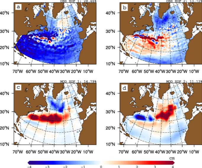
The gyre index constructed here from satellite altimetry is related to core aspects of the North Atlantic subpolar gyre, meridional overturning circulation, hydrographic properties in the Atlantic inflows toward the Arctic, and in marine ecosystems in the northeast Atlantic Ocean. The data series spans the period January 1993 to September 2018. Data description: Monthly gyre index from January 1993 until September 2018. The data is provided in one comma separated value (csv) file with the following entries on each row: year, month, index value. The index is normalized, i.e. it has a zero mean and unit standard deviation. Positive (negative) gyre index reflects stronger (weaker) than average surface circulation of the North Atlantic subpolar gyre.
-

We assembled a dataset of 14C-based productivity measurements to understand the critical variables required for accurate assessment of daily depth-integrated phytoplankton carbon fixation (PP(PPeu)u) from measurements of sea surface pigment concentrations (Csat)(Csat). From this dataset, we developed a light-dependent, depth-resolved model for carbon fixation (VGPM) that partitions environmental factors affecting primary production into those that influence the relative vertical distribution of primary production (Pz)z) and those that control the optimal assimilation efficiency of the productivity profile (P(PBopt). The VGPM accounted for 79% of the observed variability in Pz and 86% of the variability in PPeu by using measured values of PBopt. Our results indicate that the accuracy of productivity algorithms in estimating PPeu is dependent primarily upon the ability to accurately represent variability in Pbopt. We developed a temperature-dependent Pbopt model that was used in conjunction with monthly climatological images of Csat sea surface temperature, and cloud-corrected estimates of surface irradiance to calculate a global annual phytoplankton carbon fixation (PPannu) rate of 43.5 Pg C yr‒1. The geographical distribution of PPannu was distinctly different than results from previous models. Our results illustrate the importance of focusing Pbopt model development on temporal and spatial, rather than the vertical, variability.
-

The largest landings in this ecoregion are by Norway, the Russian Federation (Russia henceforth), Faroe Islands, and Iceland, mainly by pelagic fisheries. Other nations also have fisheries in the area. The number of fishing vessels is declining while the size of the remaining vessels is increasing. The annual catch in the ecoregion has varied between 700 000 tonnes to over 2 million tonnes. The pelagic fisheries, using purse seine and pelagic trawls, account for the largest catches by weight and target herring (her.27.1-24a514a), blue whiting (whb.27.1-91214), mackerel (mac.27.nea), and other pelagic species. The largest demersal fishery targets cod (cod.27.1-2), haddock (had.27.1-2), and saithe (pok.27.1-2) using bottom trawls, purse seine, Danish seine and gillnets, and to a lesser extent hook and line gear. Smaller fisheries target other gadoid species, Greenland halibut (ghl.27.1-2), and redfish. Landings of pelagic species within the ecoregion in the last decades have been variable. The demersal fisheries, dominated by cod, display less pronounced fluctuations than the pelagic fisheries. Information about discards is sparse, but the total weight of discards is considered low in both the pelagic and the demersal fisheries. Harp seals and minke whales are hunted in the region. Status summary of Norwegian Sea stocks relative to the ICES maximum sustainable yield (MSY) approach and precautionary approach (PA) is known for 50% of the 23 stocks assessed by ICES in this ecoregion. Only 22% of the stocks are fished below FMSY, accounting for nearly 13% of the total catch. 30% of the stocks have a biomass above MSY Btrigger, accounting for 86% of the total catch. Demersal stocks have shown a trend of declining fishing mortality since the mid-1990s, and the average F/FMSY ratio is now close to 1. The mean SSB/MSY Btrigger ratio of demersal stocks has been decreasing over the last decade, but mean SSB remains above MSY Btrigger. The average F/FMSY ratio for pelagic stocks has been decreasing since 2000 and is now close to 1. The mean SSB/MSY Btrigger ratio for pelagic species has shown a slight increase over the last two decades and is above 1. In addition to biomass removal, ecosystem effects of fisheries include abrasion, ghost fishing, and bycatch of protected, endangered, and threatened species.
-
Assessments run at AFWG provide the scientific basis for the management of cod, haddock, saithe, redfish, Greenland halibut and capelin in subareas 1 and 2. Taking the catch values provided by the Norwegian fisheries ministry for Norwegian catches1 and raising the total landed value to the total catches gives an approximate nominal first-hand landed value for the combined AFWG stocks of ca. 20 billion NOK or ca. 2 billion EUR (2018 estimates).
-
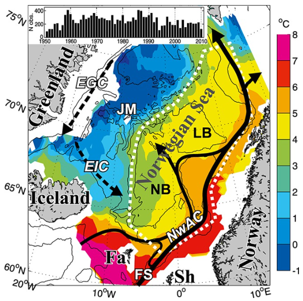
Climate variability in the Norwegian Sea was investigated in terms of ocean heat and freshwater contents of Atlantic water above a reference surface, using hydrographic data during spring 1951–2010. The main processes acting on this variability were examined and then quantified. The area-averaged water mass cooled and freshened, but a deepening of the reference surface resulted in a positive trend in the heat content of 0.3 W m−2. Air-sea heat fluxes explained about half of the interannual variability in heat content. The effect of the advection of Atlantic and Arctic waters on the variability varied with time, apparently due to large-scale changes in the ocean circulation. The data are consistent with the explanation that changing wind patterns caused buffering and then release of Arctic water in the Iceland Sea during the late 1960s to early 1970s, and this caused large hydrographic changes in the Norwegian Sea.
-

As a consequence of the impact of the COVID pandemic on international travel which prevented the traditional meeting from taking place, the Working Group on Widely Distributed Stocks (WGWIDE) met online via WebEx hosted by ICES. Prior to the 2020 meeting, the generic ToRs for species and regional working groups were re-prioritised by ACOM to allow the WG to focus primarily on those ToRs most applicable to the provision of advice. WGWIDE reports on the status and considerations for management of Northeast Atlantic mackerel, blue whiting, Western and North Sea horse mackerel, Northeast Atlantic boarfish, Norwegian springspawning herring, striped red mullet (Subareas 6, 8 and Divisions 7.a-c, e-k and 9.a), and red gurnard (Subareas 3, 4, 5, 6, 7, and 8) stocks. Northeast Atlantic (NEA) Mackerel. This stock is highly migratory and widely distributed throughout the Northeast Atlantic with significant fisheries is most ICES subareas. A diverse range of fleets from smaller artisanal, handline vessels to large (100m+) factory freezer vessels and modern RSW trawlers and purse seiners take part in what is one of the most valuable European fisheries. The assessment conducted in 2020 is an update assessment, based on the configuration agreed during the most recent inter-benchmark exercise in 2019 and incorporates the most recent data available from sampling of the commercial catch in 2019, the final 2019 egg survey SSB estimate, an updated recruitment index and tagging time series along with 2020 survey data from the IESSNS swept area survey. Advice is given based on stock reference points which were updated during a management strategy evaluation carried out in 2020. Following a strong increase from 2007 to 2014, SSB has been declining although it remains well above MSY Btrigger. Fishing mortality has been below FMSY since 2016. There have been a number of large year classes since 2001 with above average recruitment over much of the most recent decade. Blue Whiting. This pelagic gadoid is widely distributed in the eastern part of the North Atlantic. The 2020 update assessment followed the protocol from the most recent inter-benchmark in 2016 and used preliminary catch data from 2020. Due to the cancellation of the 2020 acoustic survey, this data was not available. The effect on the assessment was minimal and limited to increases in uncertainty of the terminal year estimates. The SSB continues to decrease from the most recent maximum in 2017 mainly due to below average recruitment since 2017, although it remains above MSY Btrigger. Fishing mortality has been above FMSY since 2014. Norwegian Spring Spawning Herring. This is one of the largest herring stocks in the world. It is highly migratory, spawning along the Norwegian coast and feeding throughout much of the Norwegian Sea. The 2020 assessment is based on an implementation of the XSAM assessment model introduced at the benchmark in 2016. This years’ assessment indicates that the stock is continuing to decline from the peak in 2008 of 7Mt to just above MSY Btrigger due to successive years of average or below average recruitment. Catch advice for 2021 is given on the basis of the agreed management plan and represents a substantial increase over the 2020 advice due to an upward revision in the estimate of the 2016 year-class which is considered to be the most significant year-class since 2004.
-

3-D habitat suitability maps (HSM) or probability of occurrence maps, built using Shape-Constrained Generalized Additive Models (SC-GAMs) for the 30 main commercial species of the Atlantic region. Predictor variables for each species were selected from: sea water temperature, salinity, nitrate, net primary productivity, distance to seafloor, distance to coast, and relative position to mixed layer depth. Each species HSM contains 47 maps, one per depth level from 0 to 1000 m. Probability values of each map range from 0 (unsuitable habitat) to 1 (optimal habitat). For depth levels below the 0.99 quantile of the depth values found on the species occurrence data, NA values were assigned. Maps have been masked to species native range regions. See Valle et al. (2024) in Ecological Modelling 490:110632 (https://doi.org/10.1016/j.ecolmodel.2024.110632 ), for more details.
-
Marine ferromanganese crust deposits are potential mineral resources that contain base metals and strategic and critical elements such as cooper (Cu), cobalt (Co), vanadium (V), nickel (Ni), titanium (Ti), platinum group elements (PGEs) or rare earth elements (REEs). Traditionally, marine precipitates are defined as: a) purely hydrogenetic when all constituents are derived from cold seawater, (b) diagenetic, when all constituents are derived from cold sediment pore water; and (c) hydrothermal when precipitation occurs in the vicinity of hydrothermal vent sites from fluids with temperatures higher than ambient bottom waters. Hydrogenetic Fe-Mn crusts occur throughout the global ocean on seamounts, ridges and plateaus, where currents have kept the rocks free of sediment for millions of years. Some ferromanganese (Fe-Mn) crusts exhibit a mixed origin, primarily either hydrothermal-hydrogenetic or hydrogenetic-diagenetic (Hein et al., 2000; 2003; 2013; Muiños et al. 2013; Bau et al., 2014; Marino et al., 2017). In many places, marine phosphorites are accompanied by Fe-Mn crust mineralisations on the seafloor of continental shelves and slopes along the western continental margins of the Atlantic Ocean. Some thick Fe-Mn crusts also contain carbonate fluorapatite, which was incorporated into the crusts during specific periods prior to middle Miocene during main Cenozoic episodes of phosphatization. These deposits are related to strong upwelling along the continental margins and seamounts. Marine phosphorites are known to concentrate rare earth elements and yttrium (REY) during early diagenetic formation (Hein et al., 1993; 2016; González et al., 2016). Although there are several references to ferromanganese crusts and their association with phosphorites in the literature, the genetic models for explaining their relationship and metal concentration are still poorly understood.
-
Seafloor massive sulphides (SMS) are modern equivalents of on-shore (ancient) volcanogenic massive sulphides (VMS) which have constituted important mining targets through history in many regions of Europe. VMS deposits are generally stratiform accumulations of sulphides formed at or just beneath the seafloor as a result of volcano-magmatic activity. The sulphides are precipitated from hot hydrothermal solutions when they come in contact with cold seawater. Deposits of this type that form today are known as seafloor massive sulphides, and the associated sulphurous plumes are called black and white smokers. Data from ancient VMS deposits are essential for the present-day understanding of the formation, structure and composition of SMS deposits. VMS deposits are among the most important deposit types for a number of commodities, including copper (Cu), zinc (Zn), lead (Pb), silver (Ag) and gold (Au). In addition, they may contain economic grades of cobalt (Co), tin (Sn), barium (Ba), sulphur (S), selenium (Se), indium (In), bismuth (Bi), tellurium (Te), gallium (Ga) and germanium (Ge). Several of these minor constituents are considered critical raw materials by the EU. The modern equivalents are found on the ocean floor, along present-day spreading ridges and volcanic centres, and are the target of steadily increasing attention as a possible source for both base, precious and special metals.