 Metadata catalogue
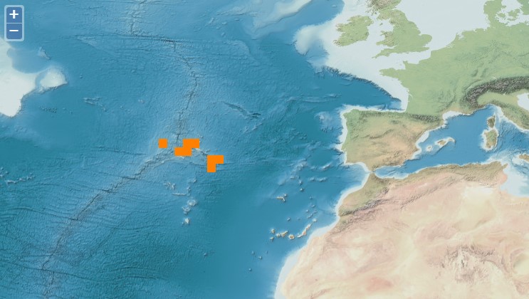
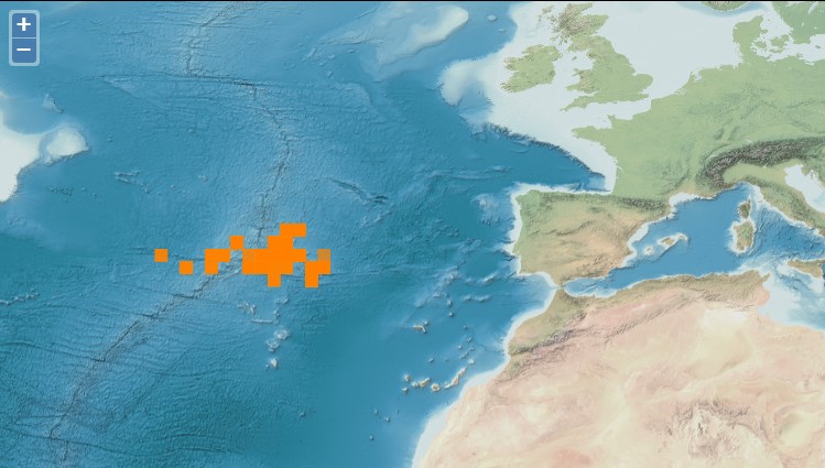
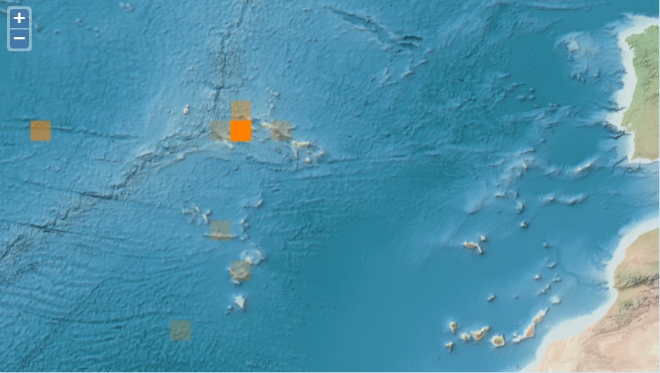
North Mid-Atlantic Ridge
Type of resources
Available actions
Topics
INSPIRE themes
Keywords
Contact for the resource
Provided by
Years
Formats
Representation types
status
Resolution
-
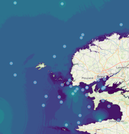
Quonops Online Services provide noise monitoring and prediction tools. In a similar manner to weather forecasting systems, Quonops© produces an estimate of the spatio-temporal distribution of noise levels generated by human activities at sea, aggregating multiple sources, and assessing short-, mid- and long-term source contributions to the global noise field. The outputs from Quonops© are tailored to the requirements of existing and emerging national and international regulations regarding: - Underwater noise. - The conservation of habitats and marine ecosystems. - The protection of marine species. Such tools aim to support management decisions by assessing, quantifying and prioritizing direct and indirect anthropogenic pressures on marine life, according to regulations on underwater noise, especially the descriptor 11 of the European Marine Strategy Framework Directive.
-
MarSP project intends to reinforce the Maritime Spatial Planning (MSP) processes in the three EU Macaronesian Archipelagos - Azores, Madeira and Canary Islands. MarSP aims to assists the competent authorities of Portugal (Azores and Madeira) and Spain (Canary Islands) on promoting the development of operative mechanisms of Maritime Spatial Planning (MSP) until 2021. Aligned with the European MSP Directive 2014/89/EU and EASME call for MSP Cross-Border cooperation for outermost regions, MarSP will focus in the cooperation of the three regions of Macaronesia (Azores, Madeira and the Canary Islands) to ensure a coherent and coordinated MSP process, taking into account the transnational issues. These three regions of the Macaronesia have been developing their own planning processes according to the Directive 2014/89/EU, national legislation and governance frameworks, which are remarkably different. Currently, each archipelago is in distinct stages of development of MSP implementation. For this reason, a complete homogenization of the approaches for the three regions is not possible and neither desirable. On the other hand, this discrepancy may represent a strong point in this project, since facing distinct MSP processes, designed to deal with similar problems, due to the same geographic context, but at distinct stages of development, will certainly bring a testing dimension to the project that is not negligible.
-
Maritime Spatial Planning (MSP) is globally recognised as a crucial tool for managing human uses and activities in maritime space, with the aim of supporting sustainable growth and development in the maritime sector and conscious use of marine and coastal resources. MSP identifies where and when human uses and activities take place in maritime space today and may take place in the future. GeoPortal SIGMAR offers a view of the maritime space of the Azores and its uses.
-
Fish assemblages surveyed by using underwater visual censuses (UVC) down to 40 m. Transects were performed between 1997 and 2015 in the Azores, Portugal. All mobile fish were identified to the lowest possible taxon. Dates, geographic coordinates and species recorded are provided. Fish assemblages were surveyed using underwater visual censuses (UVC) down to 40 m. Following standard belt transect surveys (Brock 1954), SCUBA divers sampled transects with 50 m length and 5 m width. All mobile fish were identified to the lowest possible taxon and counted. Sampling sites were chosen based on the general representativeness of the habitat. Transects within sites were selected by stratified random sampling: different transects were done in each dive without replicating the depth strata (every 10 m) or overall bottom type or crossing transects during a single dive or day. UVCs were conducted in the scope of projects CLIPE (FCT—Praxis XXI/3/3.2/EMG/1957/95), MARÉ (LIFE B4-3200/98-509), MAREFISH (FCT-POCTI/ BSE/41207/2001), OGAMP (INTERREG IIIb/MAC/4.2/A2 2001), MARMAC (INTERREGIIIb-03/MAC/4.2/A1 2004), EmpaFish (EC-FP6, SSP8-006539), MareFish (FCT, POCTI/BSE/41207/2001), MoniZEC (FRC - M2.1.2/I/018/2011)
-
Demersal surveys performed with bottom longline during research cruises around Azorean islands and several seamounts. Surveys conducted annually (few exceptions) from 1996 to 2013. Sampling is performed using a "stone-buoy longline" similar to the one used in the commercial demersal fishery in the Azores. The sampling is stratified and random based on depth and geographic areas from 25 meters to 1200 meters mostly, but few sets down to 2000 meters. In some sets a different longline design was used (see Menezes et al. 2009). Soak time was usually 2 to 3 hours, but deeper sets (below 1000 meters) have longer soaks times. Chopped and salted sardines were used as bait.
-
Other fish species caught during the tuna fishing operation that were commercialized. These species were caught along with the target species (tuna) by using pole and line. POPA was launched in 1998 with the main goal of certifying the tuna caught around the Azores as a "dolphin safe product". This label is attributed by the non-governmental organization Earth Island Institute to catches made without mortality of cetaceans. POPA has built an extensive database with information collected by the observers on board the tuna fishing vessels. This database includes information on tuna fisheries (e.g., location of fishing events, catches, and fishing effort), weather conditions (e.g., sea surface temperature, wind and visibility), live bait fisheries (e.g., location of fishing events, catches, gears used), cetaceans (e.g., occurrences, interaction with fishing events and association with other species), birds and sea turtles (e.g., occurrences). POPA is also responsible for "Friend of the Sea" tuna fishery certification. In the late 1990’s, it became clear that the tuna industry would be seriously penalized with the absence of a "dolphin safe" certification which instigated new measures from the government and the fisheries sector. In order to achieve this certification, the Azores Fisheries Observer Programme (POPA) was funded in 1998, ensuring the absence of dolphin mortality or injury in tuna fishery. Since then, fishery and fishing products are certified by the Earth Island Institute, through the results presented by POPA. Besides that, the tuna fishery is also certified as "Friend of the Sea" which means that it is extremely selective, doesn’t harm the surrounding environment and is quite sustainable. It became the first tuna fishery in the world achieving that certification. The Programme results from an agreement among Regional Administration, Earth Island Institute, the Tuna Canning Industry Association (Pão do Mar), the Fishing Boat Owners Association (APASA) and IMAR - Instituto do Mar - through the University of The Azores Center (IMAR-DOP/Uaç), which carries out the programme. Until 2003, the Programme was supported by regional funds. Between 2003 and 2005 it became co-financed by the European Commission through the INTERREG IIIb Programme/ ORPAM project. Since then it has been exclusively supported by the regional government through the Regional Secretary of Fisheries.
-
Sightings of birds were recorded daily, at 6 different fixed periods (snap shots), when the boat was in navigation or search mode. POPA was launched in 1998 with the main goal of certifying the tuna caught around the Azores as a "dolphin safe product". This label is attributed by the non-governmental organization Earth Island Institute to catches made without mortality of cetaceans. POPA has built an extensive database with information collected by the observers on board the tuna fishing vessels. This database includes information on tuna fisheries (e.g., location of fishing events, catches, and fishing effort), weather conditions (e.g., sea surface temperature, wind and visibility), live bait fisheries (e.g., location of fishing events, catches, gears used), cetaceans (e.g., occurrences, interaction with fishing events and association with other species), birds and sea turtles (e.g., occurrences). POPA is also responsible for "Friend of the Sea" tuna fishery certification. In the late 1990’s, it became clear that the tuna industry would be seriously penalized with the absence of a "dolphin safe" certification which instigated new measures from the government and the fisheries sector. In order to achieve this certification, the Azores Fisheries Observer Programme (POPA) was funded in 1998, ensuring the absence of dolphin mortality or injury in tuna fishery. Since then, fishery and fishing products are certified by the Earth Island Institute, through the results presented by POPA. Besides that, the tuna fishery is also certified as "Friend of the Sea" which means that it is extremely selective, doesn’t harm the surrounding environment and is quite sustainable. It became the first tuna fishery in the world achieving that certification. The Programme results from an agreement among Regional Administration, Earth Island Institute, the Tuna Canning Industry Association (Pão do Mar), the Fishing Boat Owners Association (APASA) and IMAR - Instituto do Mar - through the University of The Azores Center (IMAR-DOP/Uaç), which carries out the programme. Until 2003, the Programme was supported by regional funds. Between 2003 and 2005 it became co-financed by the European Commission through the INTERREG IIIb Programme/ ORPAM project. Since then it has been exclusively supported by the regional government through the Regional Secretary of Fisheries.
-
The CETUS dataset contains effort-based occurrence records collected during a cetacean monitoring programme in the Eastern North Atlantic, since 2012. The CETUS dataset contains data collected within the CETUS Project (www.cetusproject.com), a cetacean monitoring programme in the Eastern North Atlantic, running since 2012. The project is led by the Interdisciplinary Centre of Marine and Environmental Research (CIIMAR - University of Porto, Portugal), in partnership with TRANSINSULAR - Grupo ETE, a Portuguese company for maritime transport, that offers its cargo ships to be used as a platforms of opportunity to monitor cetaceans along routes between Continental Portugal and Madeira, Azores, Canary and Cape Verde islands. On-board trained marine mammal observers collect data on: survey effort, cetacean and other megafauna occurrences, as well as marine traffic and meteorological conditions. Data is provided in the recent OBIS-ENV-DATA format, and comprises 8913 georeferenced positions associated with 3195 occurrences of 44 marine taxa.
-
Sightings (snap shots) of marine mammals collected by Biosphere Expeditions collaborators specifically for POPA. Since 2004 Biosphere Expeditions (www.biosphere-expeditions.org) collects data for POPA in the Azores central group in April and May. POPA was launched in 1998 with the main goal of certifying the tuna caught around the Azores as a "dolphin safe product". This label is attributed by the non-governmental organization Earth Island Institute to catches made without mortality of cetaceans. POPA has built an extensive database with information collected by the observers on board the tuna fishing vessels. This database includes information on tuna fisheries (e.g., location of fishing events, catches, and fishing effort), weather conditions (e.g., sea surface temperature, wind and visibility), live bait fisheries (e.g., location of fishing events, catches, gears used), cetaceans (e.g., occurrences, interaction with fishing events and association with other species), birds and sea turtles (e.g., occurrences). POPA is also responsible for "Friend of the Sea" tuna fishery certification. In the late 1990’s, it became clear that the tuna industry would be seriously penalized with the absence of a "dolphin safe" certification which instigated new measures from the government and the fisheries sector. In order to achieve this certification, the Azores Fisheries Observer Programme (POPA) was funded in 1998, ensuring the absence of dolphin mortality or injury in tuna fishery. Since then, fishery and fishing products are certified by the Earth Island Institute, through the results presented by POPA. Besides that, the tuna fishery is also certified as "Friend of the Sea" which means that it is extremely selective, doesn’t harm the surrounding environment and is quite sustainable. It became the first tuna fishery in the world achieving that certification. The Programme results from an agreement among Regional Administration, Earth Island Institute, the Tuna Canning Industry Association (Pão do Mar), the Fishing Boat Owners Association (APASA) and IMAR - Instituto do Mar - through the University of The Azores Center (IMAR-DOP/Uaç), which carries out the programme. Until 2003, the Programme was supported by regional funds. Between 2003 and 2005 it became co-financed by the European Commission through the INTERREG IIIb Programme/ ORPAM project. Since then it has been exclusively supported by the regional government through the Regional Secretary of Fisheries.
-

Information collected by the observers on board the tuna fishing vessels on tuna fisheries, weather conditions, live bait fisheries, cetaceans, birds and sea turtles. POPA was launched in 1998 with the main goal of certifying the tuna caught around the Azores as a "dolphin safe product". This label is attributed by the non-governmental organization Earth Island Institute to catches made without mortality of cetaceans. POPA has built an extensive database with information collected by the observers on board the tuna fishing vessels. This database includes information on tuna fisheries (e.g., location of fishing events, catches, and fishing effort), weather conditions (e.g., sea surface temperature, wind and visibility), live bait fisheries (e.g., location of fishing events, catches, gears used), cetaceans (e.g., occurrences, interaction with fishing events and association with other species), birds and sea turtles (e.g., occurrences). POPA is also responsible for "Friend of the Sea" tuna fishery certification. In the late 1990’s, it became clear that the tuna industry would be seriously penalized with the absence of a "dolphin safe" certification which instigated new measures from the government and the fisheries sector. In order to achieve this certification, the Azores Fisheries Observer Programme (POPA) was funded in 1998, ensuring the absence of dolphin mortality or injury in tuna fishery. Since then, fishery and fishing products are certified by the Earth Island Institute, through the results presented by POPA. Besides that, the tuna fishery is also certified as "Friend of the Sea" which means that it is extremely selective, doesn’t harm the surrounding environment and is quite sustainable. It became the first tuna fishery in the world achieving that certification. The Programme results from an agreement among Regional Administration, Earth Island Institute, the Tuna Canning Industry Association (Pão do Mar), the Fishing Boat Owners Association (APASA) and IMAR - Instituto do Mar - through the University of The Azores Center (IMAR-DOP/Uaç), which carries out the programme. Until 2003, the Programme was supported by regional funds. Between 2003 and 2005 it became co-financed by the European Commission through the INTERREG IIIb Programme/ ORPAM project. Since then it has been exclusively supported by the regional government through the Regional Secretary of Fisheries.