 Metadata catalogue
Natura2000
Type of resources
Available actions
Topics
INSPIRE themes
Keywords
Contact for the resource
Provided by
Years
Formats
Representation types
Update frequencies
status
Scale
-
Carte des communautés végétales de la haute slikke et du schorre sous mapinfo par Thomas Lafon et envoyée après la remise du rapport SIBA de 2004.
-

The submission of sites to the EC entails the preparation of a datasheet and a map for each site, that is for each proposed SCI and for each SPA, unless a proposed SCI has the exact boundary as an SPA; in the latter case only one datasheet is prepared comprising all relevant information. Reference can be made to the Natura 2000 viewer - including datasheets (link: http://natura2000.eea.europa.eu/) and to the Natura 2000 database (link: http://www.eea.europa.eu/data-and-maps/data/natura-2000/) to obtain information on each Natura 2000 site for almost all of the EU Member States. Information for the sites nominated by Malta are also available through these same links.
-

Natura 2000 is a network of protected areas across the European Union, with the aim of affording protection to habitats and species of wild fauna and flora of Community interest. Conservation and management measures have to be established and implemented to ensure that the condition of the natural habitats and species for which the protected areas have been designated, is maintained and/or restored, in order to ensure their long-term survival/existence.
-

Natura 2000 - SCIs & SPAs data harmonised according INSPIRE Protected Sites data theme. The submission of sites to the EC entails the preparation of a datasheet and a map for each site, that is for each proposed SCI and for each SPA, unless a proposed SCI has the exact boundary as an SPA; in the latter case only one datasheet is prepared comprising all relevant information. Reference can be made to the Natura 2000 viewer - including datasheets (link: http://natura2000.eea.europa.eu/) and to the Natura 2000 database (link: http://www.eea.europa.eu/data-and-maps/data/natura-2000/) to obtain information on each Natura 2000 site for almost all of the EU Member States. Information for the sites nominated by Malta are also available through these same links.
-
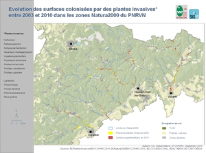
Inventaire et cartographie des plantes invasives colonisant les ZSC Haute Moder et Sauer en 2010, données ponctuelles (pour des zones dont la longueur est inférieure à 20m) Herbacées: Fallopia japonica Fallopia sachalinensis Impatiens glandulifera Phytolacca americana Rudbeckia laciniata Solidago canadensis Solidago gigantea Forestières: Pinus strobus Prunus serotina Robinia pseudacacia Rhus Typhina
-
Inventaire et cartographie des plantes invasives colonisant les ZSC Haute Moder et Sauer en 2003, données ponctuelles (pour des zones dont la longueur est inférieure à 20m) Herbacées: Fallopia japonica Fallopia sachalinensis Impatiens glandulifera Phytolacca americana Rudbeckia laciniata Solidago canadensis Solidago gigantea Forestières: Pinus strobus Prunus serotina Robinia pseudacacia Rhus Typhina
-
Inventaire et cartographie des plantes invasives colonisant les ZSC Haute Moder et Sauer en 2003 : Herbacées: Fallopia japonica Fallopia sachalinensis Impatiens glandulifera Phytolacca americana Rudbeckia laciniata Solidago canadensis Solidago gigantea Forestières: Pinus strobus Prunus serotina Robinia pseudacacia Rhus Typhina
-
Localisation des quadrats au sein desquels ont été réalisé des relevés phytosociologiques dans le cadre de l'observatoire des plantes invasives. Des relevés ont été réalisés en 2003 et en 2010 aux mêmes emplacements.
-
Localisation des points de vue des photos prises dans le cadre de l'observatoire des plantes invasives. Ces photos ont été prises en 2003 et en 2010 aux mêmes emplacements.