 Metadata catalogue
Mid-Atlantic Ridge
Type of resources
Available actions
Topics
INSPIRE themes
Keywords
Contact for the resource
Provided by
Years
Formats
Representation types
Update frequencies
Scale
-
Bathymetry - Mid-Atlantic Ridge from N 13°30 to N 24° (synthesis, 2021). Compilation of Ifremer multibeam data along the Mid-Atlantic Ridge. Grid resolution 1/16 arc minute. Bibliography: Viellefon Priscille (2020). Cartographie – Compilation et analyses numériques de données bathymétriques sur la dorsale Atlantique Nord centrale. Rapport de stage technique. https://archimer.ifremer.fr/doc/00679/79153/ Ifremer multibeam database : cruises from 1991 to 2018. Data sets acquired onboard Ifremer research vessels are processed according to a common flow : - Time and acquisition lines selection - Removing outliers by automatic filtering - Manual cleaning and residual artefact removing - Producing a digital terrain model (DTM). Depth layer is calculated as the average of soundings in each pixel. The grid resolution is 1/16 of arcminute. All DTMs are merged into a unique file. Cruise list : Fara-Seadma1, 1991, RV L’Atalante, https://doi.org/10.17600/91004411 Fara Sigma, 1991, RV L’Atalante, https://doi.org/10.17600/91004311 Faranaut/15N, 1992, RV L’Atalante, https://doi.org/10.17600/92000311 Dormasis, 1992, RV L’Atalante, https://doi.org/10.17600/92000411 Sudacores, 1998, RV L’Atalante, https://doi.org/10.17600/98010080 Bicose, 2014, RV Pourquoi Pas ?, https://doi.org/10.17600/14000100 Leve-SMF, 2016, RV Pourquoi Pas ?, https://doi.org/10.17600/16010800 Hermine, 2017, RV Pourquoi Pas ?, https://doi.org/10.17600/17000200 Transect, 2018, RV L’Atalante, https://doi.org/10.17600/18000513
-

Bathymetry - Mid-Atlantic Ridge from N 24°to N 36° (synthesis, 2021). Compilation of Ifremer multibeam data along the Mid-Atlantic Ridge. Grid resolution 1/16 arc minute. Bibliography: Viellefon Priscille (2020). Cartographie – Compilation et analyses numériques de données bathymétriques sur la dorsale Atlantique Nord centrale. Rapport de stage technique. https://archimer.ifremer.fr/doc/00679/79153/ Ifremer multibeam database : cruises from 1991 to 2018 Data sets acquired onboard Ifremer research vessels are processed according to a common flow : - Time and acquisition lines selection - Removing outliers by automatic filtering - Manual cleaning and residual artefact removing - Producing a digital terrain model (DTM). Depth layer is calculated as the average of soundings in each pixel. The grid resolution is 1/16 of arcminute. All DTMs are merged into a unique file. Cruise list : Sara, 1990, RV Jean Charcot, https://doi.org/10.17600/90000411 Fara-Seadma1, 1991, RV L’Atalante, https://doi.org/10.17600/91004411 Fara Sigma, 1991, RV L’Atalante, https://doi.org/10.17600/91004311 Faranaut/15N, 1992, RV L’Atalante, https://doi.org/10.17600/92000311 Dormasis, 1992, RV L’Atalante, https://doi.org/10.17600/92000411 Sudacores, 1998, RV L’Atalante, https://doi.org/10.17600/98010080 Bicose, 2014, RV Pourquoi Pas ?, https://doi.org/10.17600/14000100 Leve-SMF, 2016, RV Pourquoi Pas ?, https://doi.org/10.17600/16010800 Hermine, 2017, RV Pourquoi Pas ?, https://doi.org/10.17600/17000200 Transect, 2018, RV L’Atalante, https://doi.org/10.17600/18000513
-
Ages obtained through the 40Ar/39Ar method for basalt samples with the Nautile submersible along the axis of the Mid-Atlantic Ridge south of the Romanche transform fault. Major elements measurements were performed on the same samples. For a complete description of the method and discussion of results, please refer to the Grenet et al. 2023 article.
-
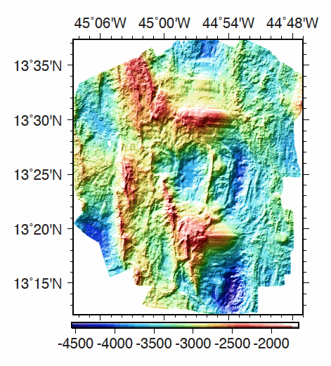
Multibeam bathymetry data, gridded at 40m, acquired around the 13°20'N and 13°30'N oceanic detachments along the Mid-Atlantic Ridge. Bathymetric data was acquired by the PourQUoi Pas? multibeam system (RESON 7150). Data is provided as a grid in GRD format (GMT NETCDF). grdinfo of the file: - ODEMAR_Shipboard_Bathymetry_40m.grd: Title: Bathy_40m.grd - ODEMAR_Shipboard_Bathymetry_40m.grd: Command: File written by MATLAB function grdwrite2.m - ODEMAR_Shipboard_Bathymetry_40m.grd: Remark: Created 22-Nov-2014 16:35:13 - ODEMAR_Shipboard_Bathymetry_40m.grd: Gridline node registration used [Cartesian grid] - ODEMAR_Shipboard_Bathymetry_40m.grd: Grid file format: nf = GMT netCDF format (32-bit float), COARDS, CF-1.5 - ODEMAR_Shipboard_Bathymetry_40m.grd: x_min: -45.14293893 x_max: -44.77177893 x_inc: 0.00036 name: x nx: 1032 - ODEMAR_Shipboard_Bathymetry_40m.grd: y_min: 13.20017553 y_max: 13.62389553 y_inc: 0.00036 name: y ny: 1178 - ODEMAR_Shipboard_Bathymetry_40m.grd: z_min: -4498.29248047 z_max: -1935.33117676 name: z - ODEMAR_Shipboard_Bathymetry_40m.grd: scale_factor: 1 add_offset: 0 - ODEMAR_Shipboard_Bathymetry_40m.grd: format: classic
-
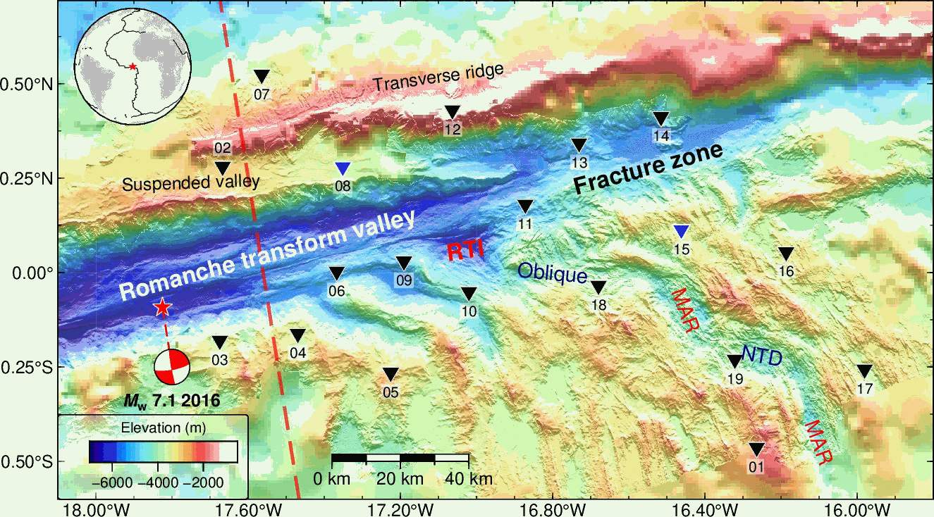
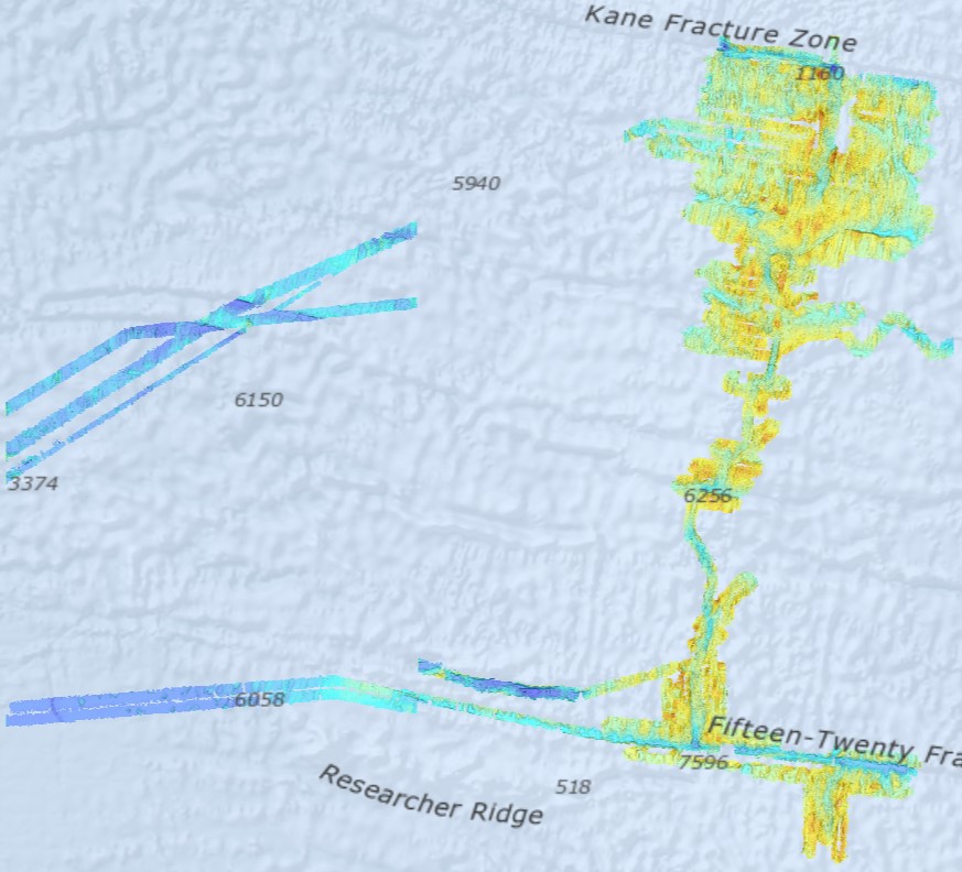
This dataset contains seismic data from 17 OBS collected in the equatorial Atlantic Ocean during the SMARTIES cruise in 2019. 12 OBSs are located along the eastern Romanche transform and fracture zone, and 5 OBSs are located along the Mid-Atlantic Ridge. The OBS data are vertical components and recorded in MiniSEED format. The data collection started from 2019-07-20T00:00:00 to 2019-08-16T24:00:00. This dateset includes raw data from OBS #10 to OBS#19. OBS#15 recorded no data. Data from OBS#1 to OBS#9 are available from a companion dataset. OBS#8 was lost.
-
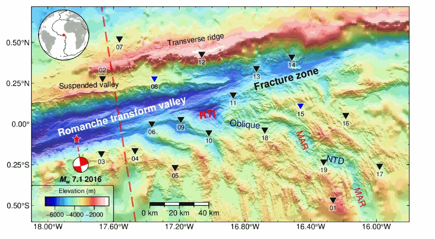
This dataset contains seismic data from 17 OBS collected in the equatorial Atlantic Ocean during the SMARTIES cruise in 2019. 12 OBSs are located along the eastern Romanche transform and fracture zone, and 5 OBSs are located along the Mid-Atlantic Ridge. The OBS data are vertical components and recorded in MiniSEED format. The data collection started from 2019-07-20T00:00:00 to 2019-08-16T24:00:00. This dateset includes raw data from OBS #1 to OBS#9. OBS#8 was lost. Data from OBS#10 to OBS#19 are available from a companion dataset. OBS#15 recorded no data.
-
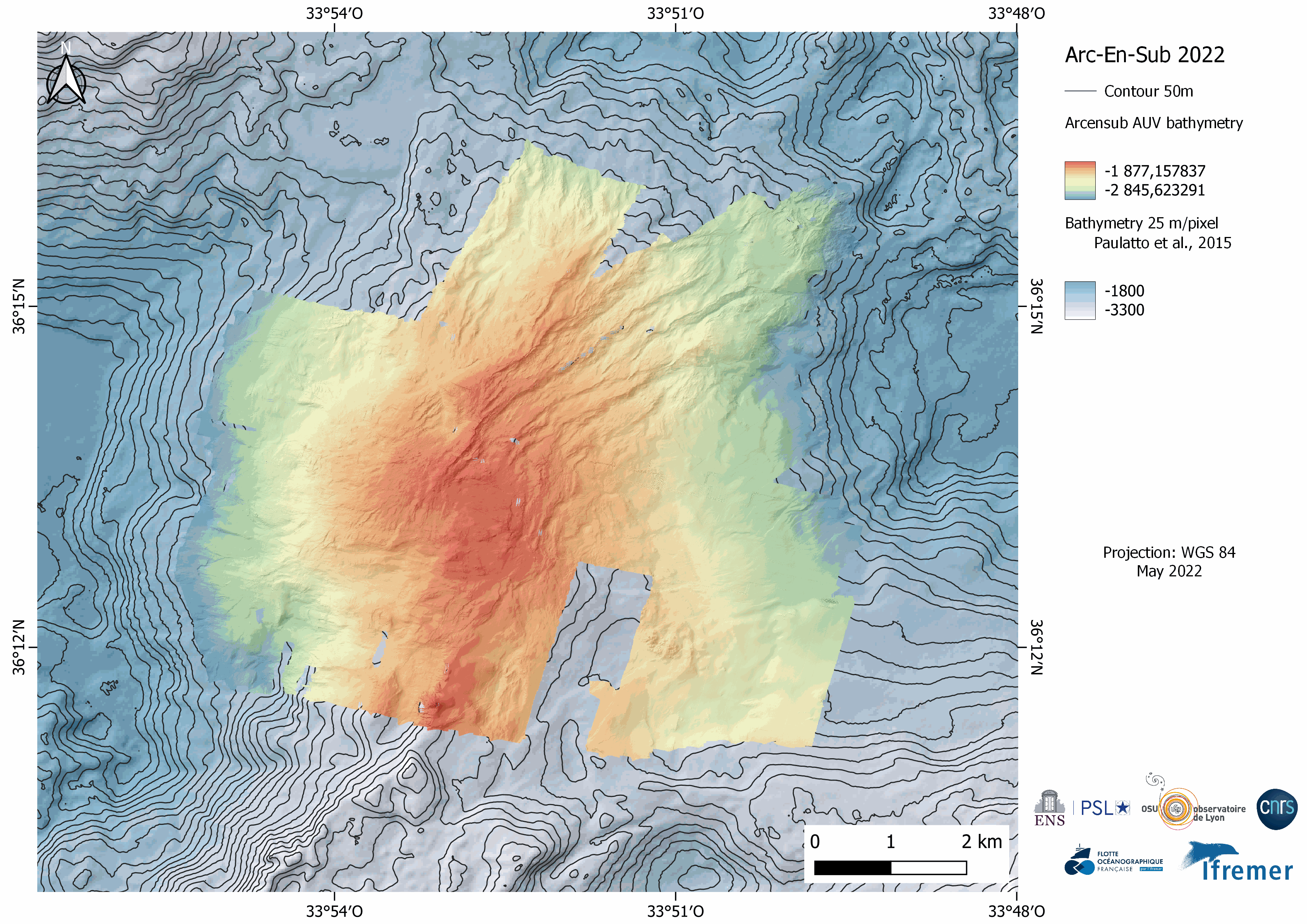
Near-bottom multibeam bathymetry and acoustic backscatter acquired at the Rainbow Massif (Mid-Atlantic Ridge). High-resolution bathymetry data (2 m/pixel) were acquired by the autonomous underwater vehicle (AUV) IdefX, deployed during the ARC-EN-SUB (https://doi.org/10.17600/18000663) cruise in May 2022. The dataset consists of grids for each individual AUV dive, as well as a global grid merging the ten completed dives. This global grid was obtained by manually shifting and combining original bathymetric grids of each dive using other datasets (primarily shipboard bathymetry from Paulatto et al. [2015]) for geographical reference. The combined grid shows the inter-dive shift artefacts, absent in the individual dive grids. Elevation grids are provided for each AUV dive without interpolation (fillgap 0), with medium (fillgap 3) and high (fillgap 15) interpolation.Acoustic backscatter grids are edited without interpolation (fillgap 0). All grids are provided in NETCDF GMT .grd format, and with two associated GEOTIFFS with the bathymetry DEM, the acoustic backscatter, and the hillshade (illumination) file. All grids are given in WGS84 (WGS 84 - WGS84 - EPSG:4326), in projection Mercator.
-
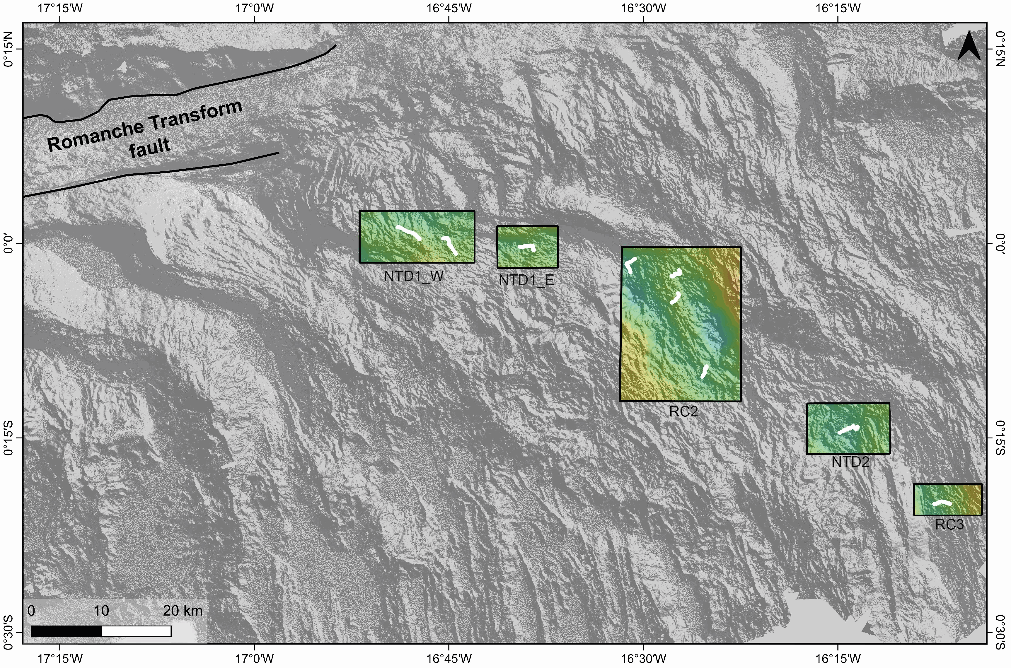
Gridded shipboard multibeam bathymetry and backscatter mosaics along the axis of the Mid-Atlantic Ridge. The used data are part of the dataset acquired during the SMARTIES cruise (2019). The gridded datasets cover different portions of the axis of the Mid-Atlantic Ridge south of the Romanche transform fault. Bathymetry grids format: nf = GMT netCDF format (32-bit float), CF-1.7 area NTD1_W grid information: x_min: -16.8647 x_max: -16.716917313 x_inc: 0.000180003272838 name: x n_columns: 822 y_min: -0.0246146868 y_max: 0.0418 y_inc: 0.000179985601084 name: y n_rows: 370 area NTD1_E grid information: x_min: -16.6878 x_max: -16.6098585829 x_inc: 0.000180003272748 name: x n_columns: 434 y_min: -0.0313156947 y_max: 0.0225 y_inc: 0.000179985601003 name: y n_rows: 300 area RC2 grid information: x_min: -16.5302 x_max: -16.3748571756 x_inc: 0.000180003272769 name: x n_columns: 864 y_min: -0.2029041037 y_max: -0.0042 y_inc: 0.000179985601178 name: y n_rows: 1105 area NTD2 grid information: x_min: -16.29 x_max: -16.183078056 x_inc: 0.000180003272727 name: x n_columns: 595 y_min: -0.2707547876 y_max: -0.2056 y_inc: 0.000179985601105 name: y n_rows: 363 area RC3 grid information: x_min: -16.1522 x_max: -16.065078416 x_inc: 0.000180003272727 name: x n_columns: 485 y_min: -0.3490268035 y_max: -0.30907 y_inc: 0.000179985601351 name: y n_rows: 223
-
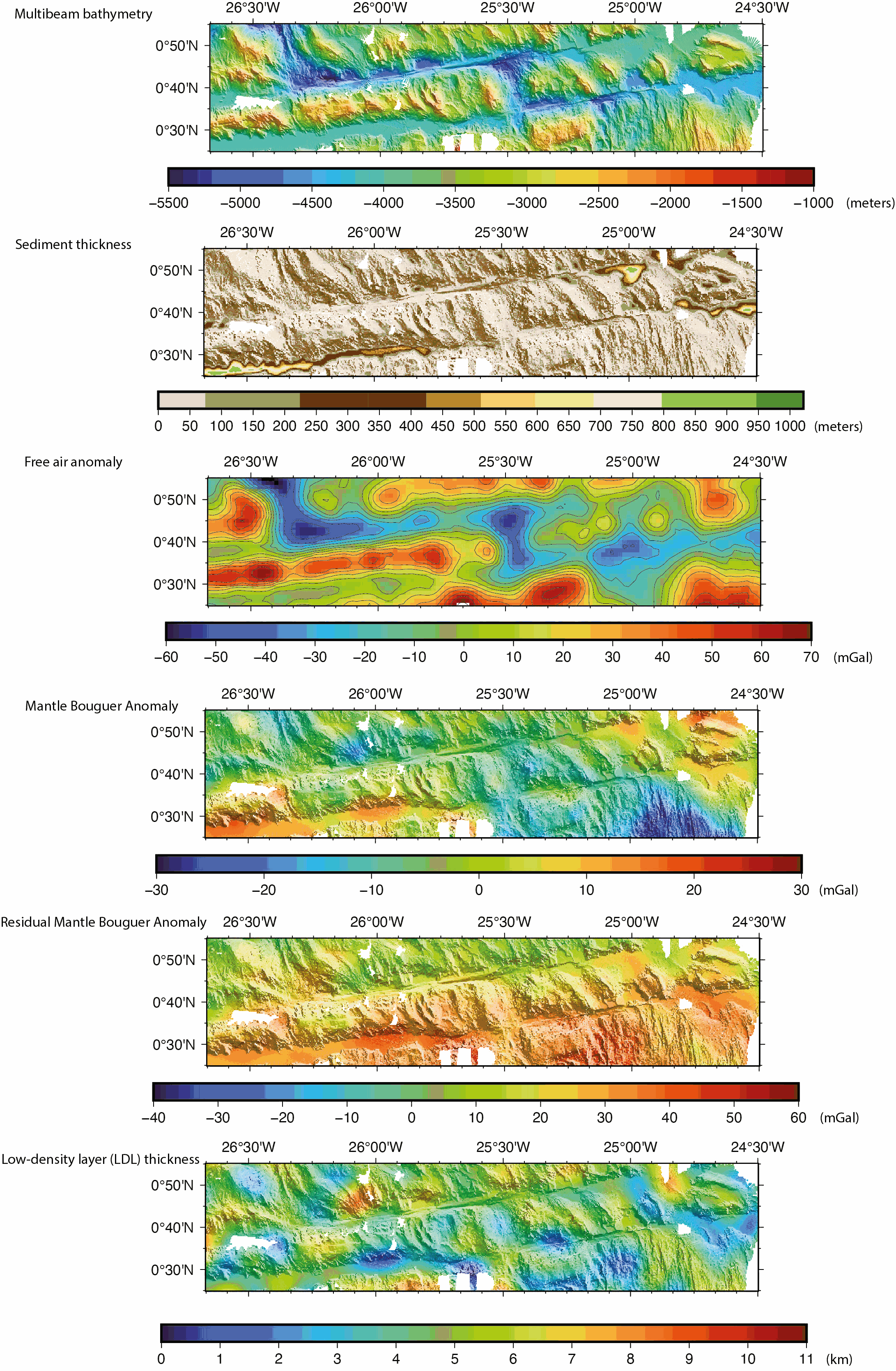
Gridded shipboard multibeam bathymetry and gravity datasets acquired during the COLMEIA cruise (2013). Gridded sediment thickness derived from seismic data. Gridded crustal thickness computed from gravity. The gridded datasets cover the South intra-transform segment of the St. Paul transform fault system. Grids created with the GMT software. Grid details as follows: Bathymetry: Grid file format: nf = GMT netCDF format (32-bit float), CF-1.7 x_min: -26.6678081446 x_max: -24.4991923884 x_inc: 0.000898349526186 name: longitude n_columns: 2415 y_min: 0.416125587833 y_max: 0.917145899441 y_inc: 0.000904368793517 name: latitude n_rows: 555 Sediment thickness: Grid file format: nf = GMT netCDF format (32-bit float), CF-1.7 x_min: -26.6697086826 x_max: -24.4984586826 x_inc: 0.00225 name: longitude n_columns: 966 y_min: 0.4154644221 y_max: 0.9194644221 y_inc: 0.00225 name: latitude n_rows: 225 Free air anomaly (merged shipboard and satellite data): Grid file format: nf = GMT netCDF format (32-bit float), CF-1.7 x_min: -26.6666666667 x_max: -24.5 x_inc: 0.0166666666667 (1 min) name: longitude n_columns: 131 y_min: 0.416666666667 y_max: 0.916666666667 y_inc: 0.0166666666667 (1 min) name: latitude n_rows: 31 Gravity anomalies (Mantle Bouguer, Residual Mantle Bouguer): Grid file format: nf = GMT netCDF format (32-bit float), CF-1.7 x_min: -26.6666666667 x_max: -24.5 x_inc: 0.00333333333333 (12 sec) name: longitude n_columns: 651 y_min: 0.416666666667 y_max: 0.916666666667 y_inc: 0.00333333333333 (12 sec) name: latitude n_rows: 151 Crustal thickness derived from the gravity anomalies: Grid file format: nf = GMT netCDF format (32-bit float), CF-1.7 x_min: -26.6666666667 x_max: -24.5 x_inc: 0.00333333333333 (12 sec) name: longitude n_columns: 651 y_min: 0.416666666667 y_max: 0.916666666667 y_inc: 0.00333333333333 (12 sec) name: latitude n_rows: 151
-
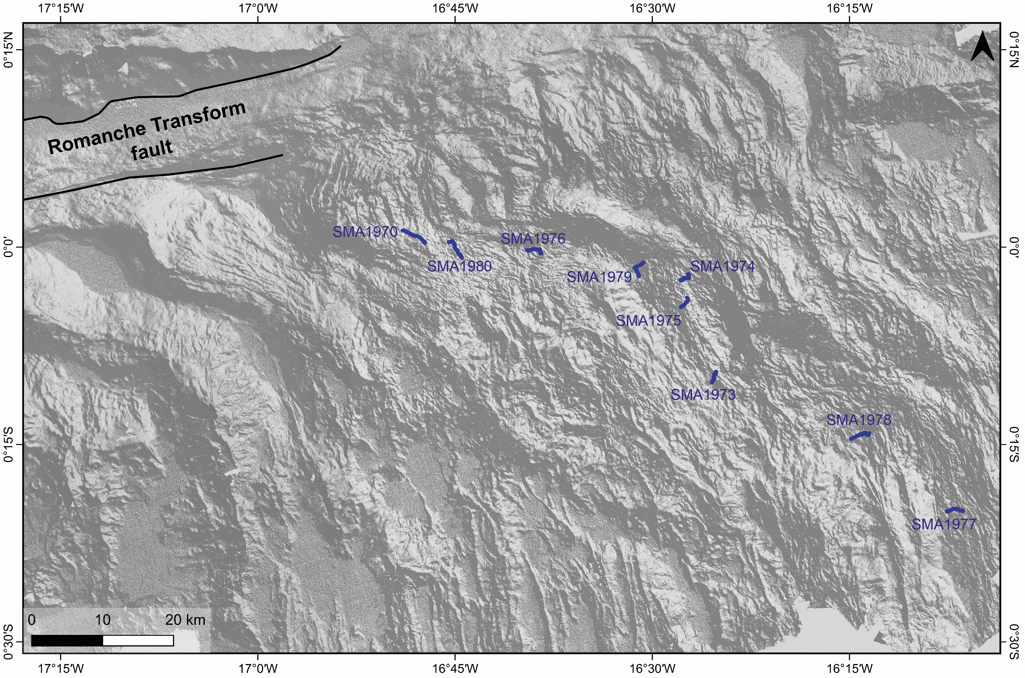
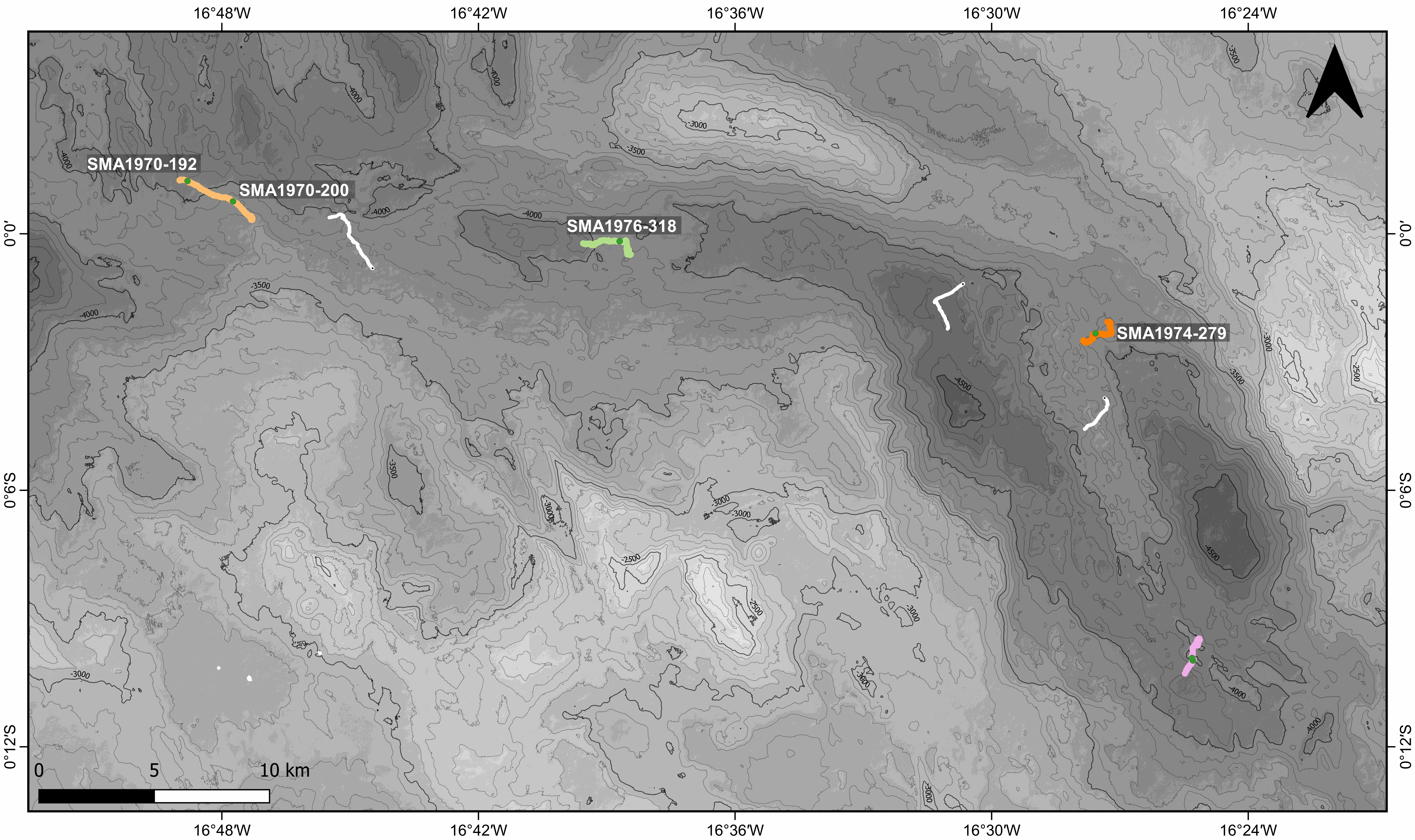
Videos recorded during the SMARTIES cruise with the Nautile cameras (fixed and mobile) during dives along the axial domain of the Mid-Atlantic Ridge south of Romanche transform fault. The following dives are part of this datatset: - SMA-1970 - SMA-1973 - SMA-1974 - SMA-1975 - SMA-1976 - SMA-1977 - SMA-1978 - SMA-1979 - SMA-1980 These videos illustrate different volcanic structures along the neo-volcanic zone of the ridge axis. The dives explored two non-transform discontinuities and two ridge segments between Romanche and Chain transform faults (RC-2 and RC-3). Dives SMA-1970 , SMA-1976 and SMA-1980 explored volcanic formations inside a large non-transform discontinuity between segments RC-1 and RC-2. Dive SMA-1978 explored the floor of the discontinuity between segments RC-2 and RC-3. Dives SMA-1973, SMA-1974, SMA-1975 and SMA-1979 explored different parts of the neo-volcanic ridge of segment RC-2. Dive SMA-1977 explored volcanic formations in the northern part of segment RC-3. The detailed study of these videos were published in Grenet et al., 2023 associated paper.