 Metadata catalogue
Marine geophysics
Type of resources
Available actions
Topics
Keywords
Contact for the resource
Provided by
Years
Formats
-
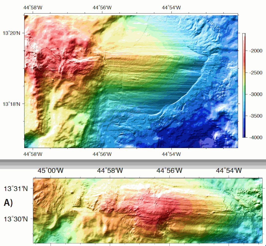
ODEMAR AUV Abyss (GEOMAR) + shipboard Pourquoi Pas? multibeam bathymetry - 13deg20minN Oceanic Core Complex, Mid Atlantic Ridge Microbathymetry acquired with AUV REMOS 6000 with a SeaBat RESON 7125 multibeam system. Bathymetry data gridded at 2 m (GMT grdfile) - one grid for 13deg20'N Oceanic Core Complex, and one grid for 13deg30'N Oceanic Core Complex - DM_OCC1320_AUV_SHI.grd: Title: ODM_OCC1320_AUV2.grd - ODM_OCC1320_AUV_SHI.grd: Command: grdmath ODM_OCC1320_AUV2.grd ODM_OCC1320_SHI2.grd AND = ODM_OCC1320_AUV_SHI.grd - ODM_OCC1320_AUV_SHI.grd: Remark: - ODM_OCC1320_AUV_SHI.grd: Gridline node registration used [Cartesian grid] - ODM_OCC1320_AUV_SHI.grd: Grid file format: nf = GMT netCDF format (32-bit float), COARDS, CF-1.5 - ODM_OCC1320_AUV_SHI.grd: x_min: -44.97115 x_max: -44.86795 x_inc: 1.7947826087e-05 name: x nx: 5751 - ODM_OCC1320_AUV_SHI.grd: y_min: 13.27915 y_max: 13.34155 y_inc: 1.79361885599e-05 name: y ny: 3480 - ODM_OCC1320_AUV_SHI.grd: z_min: -3924.5378418 z_max: -1905.49023438 name: z - ODM_OCC1320_AUV_SHI.grd: scale_factor: 1 add_offset: 0 - ODM_OCC1320_AUV_SHI.grd: format: classic - ODM_OCC1330_AUV_SHI.grd: Command: grdmath ODM_OCC1330_AUV2.grd ODM_OCC1330_SHI2.grd AND = ODM_OCC1330_AUV_SHI.grd - ODM_OCC1330_AUV_SHI.grd: Remark: - ODM_OCC1330_AUV_SHI.grd: Gridline node registration used [Cartesian grid] - ODM_OCC1330_AUV_SHI.grd: Grid file format: nf = GMT netCDF format (32-bit float), COARDS, CF-1.5 - ODM_OCC1330_AUV_SHI.grd: x_min: -45.00965 x_max: -44.88125 x_inc: 1.79454926625e-05 name: x nx: 7156 - ODM_OCC1330_AUV_SHI.grd: y_min: 13.48665 y_max: 13.52225 y_inc: 1.79254783484e-05 name: y ny: 1987 - ODM_OCC1330_AUV_SHI.grd: z_min: -3244.60083008 z_max: -2087.49829102 name: z - ODM_OCC1330_AUV_SHI.grd: scale_factor: 1 add_offset: 0 - ODM_OCC1330_AUV_SHI.grd: format: classic
-
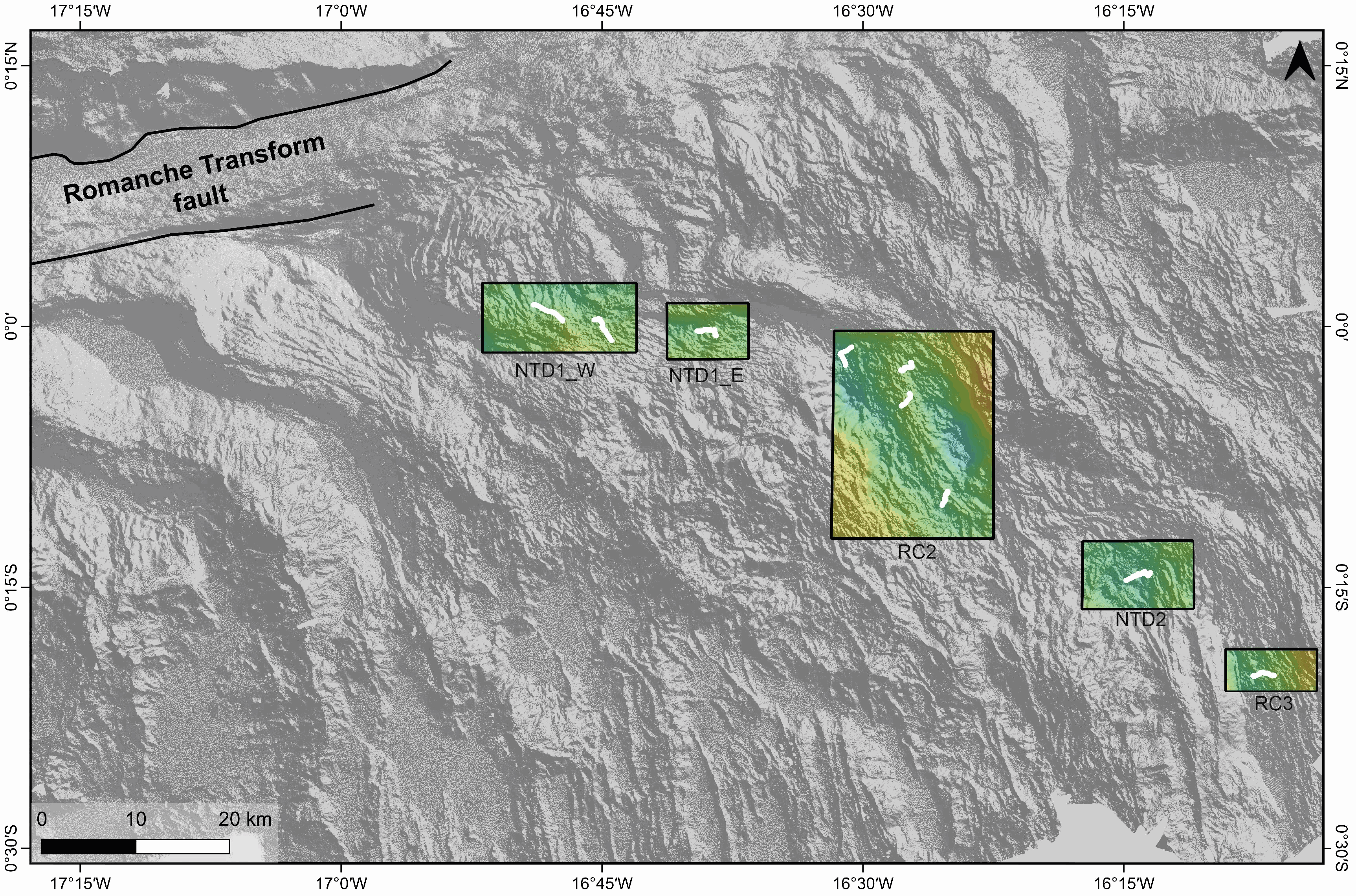
Gridded shipboard multibeam bathymetry and backscatter mosaics along the axis of the Mid-Atlantic Ridge. The used data are part of the dataset acquired during the SMARTIES cruise (2019). The gridded datasets cover different portions of the axis of the Mid-Atlantic Ridge south of the Romanche transform fault. Bathymetry grids format: nf = GMT netCDF format (32-bit float), CF-1.7 area NTD1_W grid information: x_min: -16.8647 x_max: -16.716917313 x_inc: 0.000180003272838 name: x n_columns: 822 y_min: -0.0246146868 y_max: 0.0418 y_inc: 0.000179985601084 name: y n_rows: 370 area NTD1_E grid information: x_min: -16.6878 x_max: -16.6098585829 x_inc: 0.000180003272748 name: x n_columns: 434 y_min: -0.0313156947 y_max: 0.0225 y_inc: 0.000179985601003 name: y n_rows: 300 area RC2 grid information: x_min: -16.5302 x_max: -16.3748571756 x_inc: 0.000180003272769 name: x n_columns: 864 y_min: -0.2029041037 y_max: -0.0042 y_inc: 0.000179985601178 name: y n_rows: 1105 area NTD2 grid information: x_min: -16.29 x_max: -16.183078056 x_inc: 0.000180003272727 name: x n_columns: 595 y_min: -0.2707547876 y_max: -0.2056 y_inc: 0.000179985601105 name: y n_rows: 363 area RC3 grid information: x_min: -16.1522 x_max: -16.065078416 x_inc: 0.000180003272727 name: x n_columns: 485 y_min: -0.3490268035 y_max: -0.30907 y_inc: 0.000179985601351 name: y n_rows: 223
-
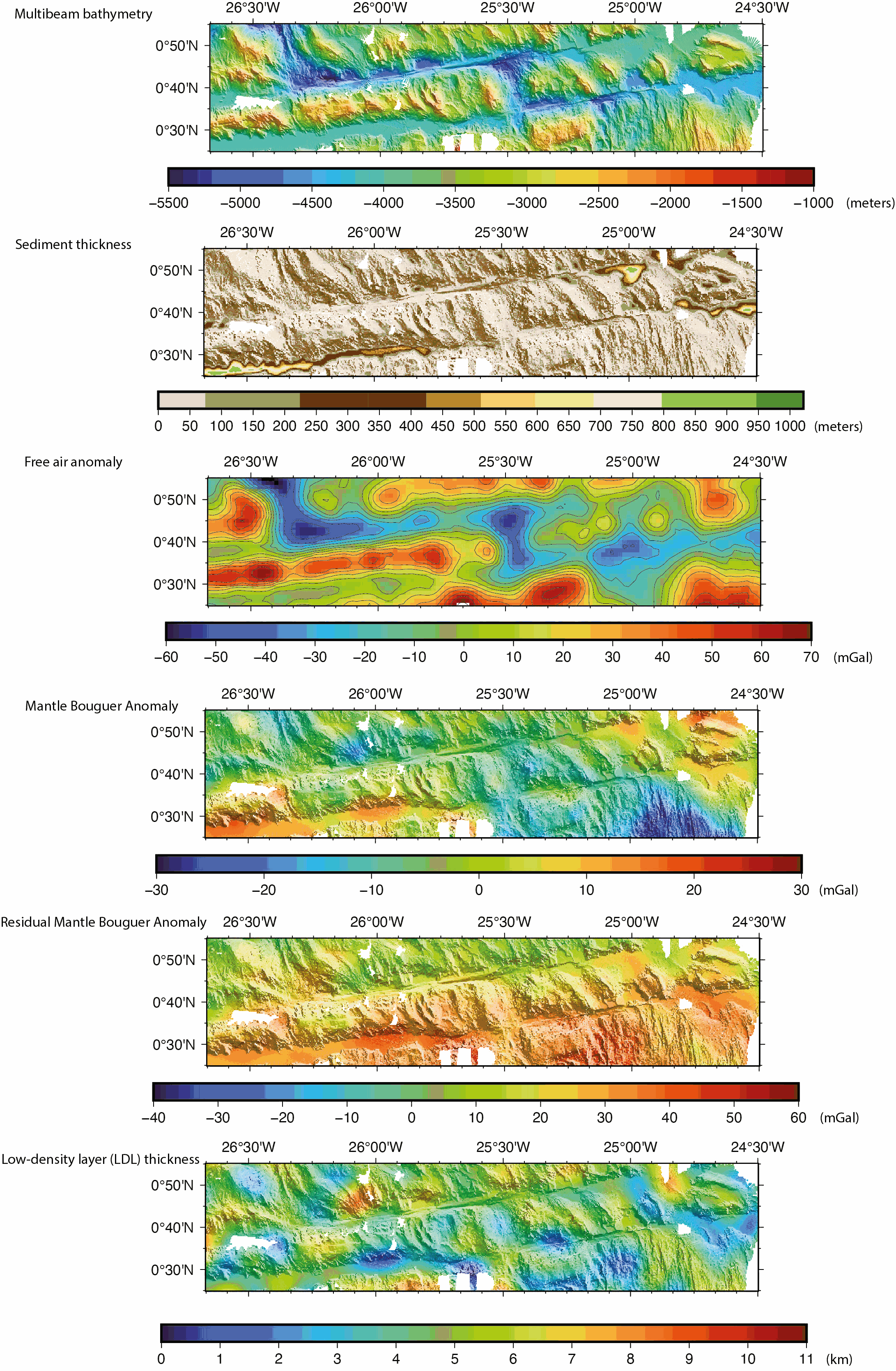
Gridded shipboard multibeam bathymetry and gravity datasets acquired during the COLMEIA cruise (2013). Gridded sediment thickness derived from seismic data. Gridded crustal thickness computed from gravity. The gridded datasets cover the South intra-transform segment of the St. Paul transform fault system. Grids created with the GMT software. Grid details as follows: Bathymetry: Grid file format: nf = GMT netCDF format (32-bit float), CF-1.7 x_min: -26.6678081446 x_max: -24.4991923884 x_inc: 0.000898349526186 name: longitude n_columns: 2415 y_min: 0.416125587833 y_max: 0.917145899441 y_inc: 0.000904368793517 name: latitude n_rows: 555 Sediment thickness: Grid file format: nf = GMT netCDF format (32-bit float), CF-1.7 x_min: -26.6697086826 x_max: -24.4984586826 x_inc: 0.00225 name: longitude n_columns: 966 y_min: 0.4154644221 y_max: 0.9194644221 y_inc: 0.00225 name: latitude n_rows: 225 Free air anomaly (merged shipboard and satellite data): Grid file format: nf = GMT netCDF format (32-bit float), CF-1.7 x_min: -26.6666666667 x_max: -24.5 x_inc: 0.0166666666667 (1 min) name: longitude n_columns: 131 y_min: 0.416666666667 y_max: 0.916666666667 y_inc: 0.0166666666667 (1 min) name: latitude n_rows: 31 Gravity anomalies (Mantle Bouguer, Residual Mantle Bouguer): Grid file format: nf = GMT netCDF format (32-bit float), CF-1.7 x_min: -26.6666666667 x_max: -24.5 x_inc: 0.00333333333333 (12 sec) name: longitude n_columns: 651 y_min: 0.416666666667 y_max: 0.916666666667 y_inc: 0.00333333333333 (12 sec) name: latitude n_rows: 151 Crustal thickness derived from the gravity anomalies: Grid file format: nf = GMT netCDF format (32-bit float), CF-1.7 x_min: -26.6666666667 x_max: -24.5 x_inc: 0.00333333333333 (12 sec) name: longitude n_columns: 651 y_min: 0.416666666667 y_max: 0.916666666667 y_inc: 0.00333333333333 (12 sec) name: latitude n_rows: 151