 Metadata catalogue
Marine geology
Type of resources
Available actions
Topics
INSPIRE themes
Keywords
Contact for the resource
Provided by
Years
Formats
Update frequencies
Service types
Scale
Resolution
-
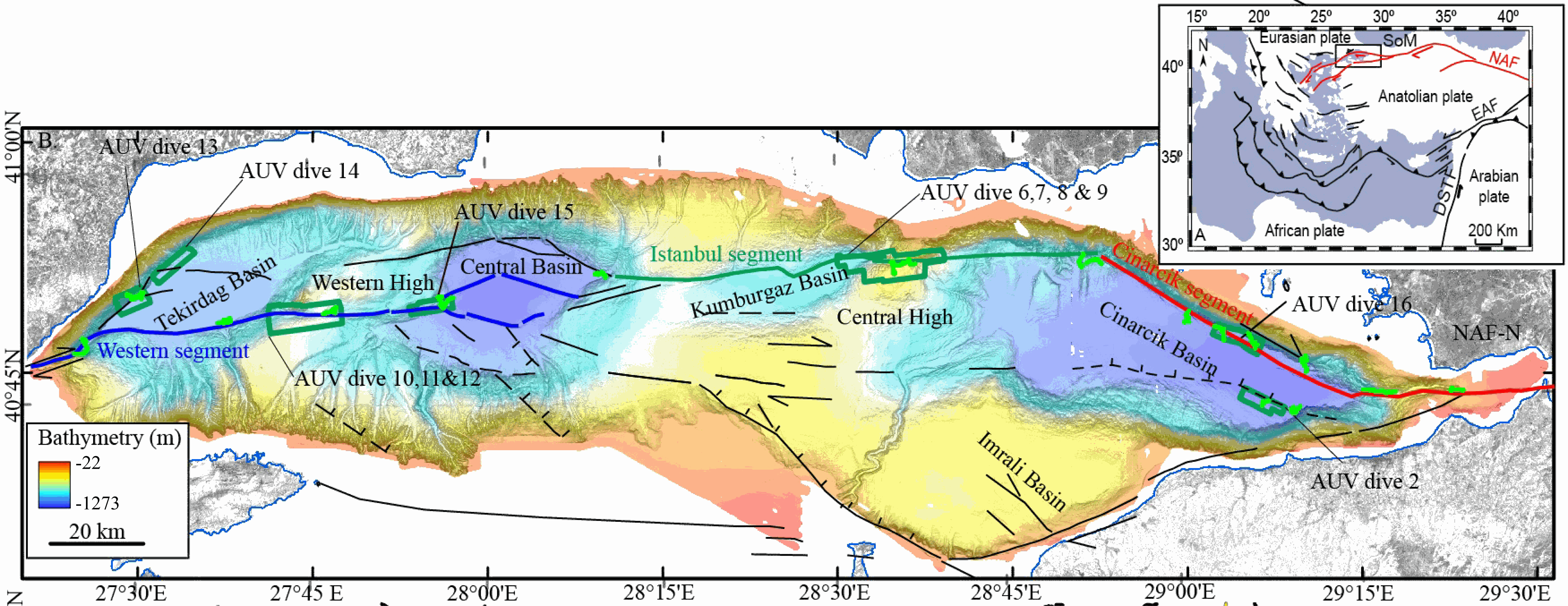
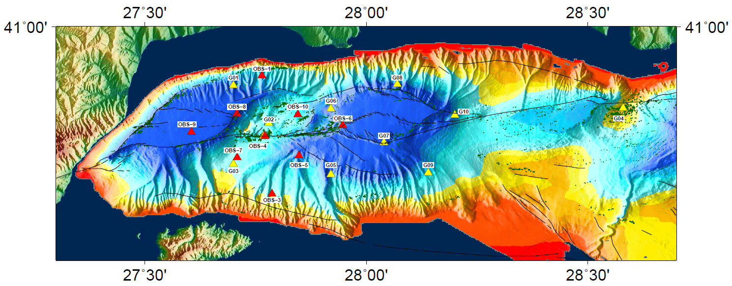
This data set contains processed multibeam sounder data from 12 dives of AsterX AUV performed on active faults scarps of the North Anatolian Fault system in the Sea of Marmara during the Marmesonet cruise (2009). The AUV carried a SIMRAD EM2000 multibeam echosounder, operating at 200 kHz, and surveyed at 50 to 70 m altitude, allowing a swath width of 150-200 m. Digital Elevation Models (DEM, in meters below sealevel) and seafloor backscatter intensity mosaics (relative amplitude in dB) are provided for 7 zones: Tekirdağ Basin W (dive 13), Tekirdağ Basin NW (dive 14), Western High (dives 10, 11 and 12), Western High E (dive 15), Central High (dive 6,7,8 and 9), Çınarcık Basin N (dive 16), Çınarcık Basin S (dive 2) (see figure). The horizontal resolution and grid pixel size of the DEM is 2 m. That of the backscatter intensity image is 1 m. Two versions of the DEM are provided. Version 1 is consistent with the backscatter image. Version 2 was updated applying a Fofonoff correction to the depths and relocating part of the AUV multibeam sounding points to fit EM302 shipborne multibeam maps. Version 2 depths and absolute positions are more accurate (10 m in the WGS-84 reference frame), but Version 1 will give better results if the backscatter image is applied as a texture or shading on the DEM. DEM and Backscatter raster files are provided in GeoTIFF format (readable with ArcGis 10.3 and QGIS 3) and use projected cartesian coordinates. They were converted from CARAIBES (Ifremer bathymetry and imagery processing software) output raster files with QGIS using GDAL translator. The Coordinate Reference System is a world Mercator projection based on WGS-84 datum, using meter units and a standard parallel at N40° latitude (latitude of preserved scale) {proj4: +proj=merc +lon_0=0 +lat_ts=+40 +x_0=0 +y_0=0 +datum=WGS84 +units=m +no_defs}. For GIS skeptics, one possible way to use these grids with Generic Mapping Tools is to perform a reverse projection back to geographic coordinates. Assuming the default PROJ_ELLIPSOID is properly set to WGS-84, the reverse projection can be applied (using gmt version 5) with the following command line: gmt grdproject AUV_XXX.tif=gd -GAUV_XXX.grd -Jm0/40/1:1 -F -C -I -V
-
During the SARDINIA experiment, CHIRP profiles, bathymetry data, three coincident MCS reflection and wide-angle seismic profiles, and one single MCS reflection profile were collected on the West Sardinia margin. The MCS reflection data was acquired using a 4.5 km 360-trace digital streamer and a tuned airgun array of 8260 cubic inches, which was towed at a depth of 18-28 m. A total of 48 ocean bottom seismometers/hydrophones (OBS/OBH) from Ifremer, University of Brest, and Geomar Kiel were deployed on the West Sardinia margin, spaced every 7 nmi (~13 km). In five locations, three OBS were deployed at the same place to ensure the collection of data. The airgun array consists of 16 airguns ranging from 100 cubic inch G-guns to 16 L Bolt airguns, with main frequencies centered around 10-15 Hz. The airguns were tuned to the first bubble, to enhance low frequencies and ensure deep penetration. The shot interval was 60 s at an average speed of 5 knots, which translates to a trace spacing of about 140-150 m. The sample rate was 8 ms for the micrOBS, 5 ms for the Geomar, and 4 ms for the OldOBS. A total of 3573 shots (profile GH: 1130, profile G2H2: 1214) were fired by the air gun array. Profiles GH and G2H2, which are 160 and 200 km long transects, respectively cross the West Sardinia margin from the continental shelf to the “atypical” oceanic crust. Twenty-one ocean bottom seismometers (OBS) were deployed on the G2H2 profile, whereas sixteen were deployed on the GH profile. Additionally, the shots on this profile were recorded by eight land seismic stations (OSIRIS stations from the University of Brest and Geosciences Azur) that extended the marine profile ~150 km onshore. For the two profiles only 33 instruments were used in the wide-angle modeling, since four instruments (OBSS06, 18a, 30a, and 30c) did not record properly. We propose here the velocity models (v.in files) of the 2 main profiles located on the West sardinian margin, Profile K7L2, located on the shelf and parallel to the margin, is not presented since most of the deep arrivals are masked by the presence of sea-bottom multiples, preventing an accurate wide-angle model.
-

During the SARDINIA experiment, three coincident MCS reflection and wide-angle seismic profiles, sub-bottom high resolution (CHIRP) profiles, and bathymetry data were collected on the Gulf of Lion margin. The seismic reflection data were acquired using a 4.5 km, 360 trace digital streamer and a tuned airgun array of 8260 in3, towed at a depth of 18-28 m. A total of 57 ocean bottom seismometer/ hydrophones (OBS/OBH) from Ifremer, University of Brest, and Geomar Kiel were deployed in the Gulf of Lion, spaced every 7 Nm (~13 km). The airgun array consists of 16 airguns ranging from 100 in3 G-guns to 16 L Bolt airguns, with main frequencies centered around 10-15 Hz. The airguns were tuned to the first bubble to enhance low frequencies and ensure a good penetration. The shot interval was 60 s at an average speed of 5 knots, which translates to a trace spacing of about 140-150 m. The sample rate was 8 ms for the micrOBS, 5 ms for the Geomar’s OBS and 4 ms for the OldOBS. A total of 6160 shots (profile AB: 3032, profile CD: 1730, profile EF: 1398) were fired by the air gun array. Profile AB crosses the Gulf of Lion’s margin, parallel to the ECORS profile, from the continental shelf to Domain III. Twenty-five ocean bottom seismometers (OBS) were deployed on this profile, of 467 km in length. Twenty-two instruments were used in the wide-angle modelling, since three instruments (OBS 45, 49 and 52) did not properly record. The shots on this profile were additionally recorded by 9 land seismic stations (OSIRIS stations from the University of Brest and Geosciences Azur) that have extended the marine profile ~120 km onshore. Profiles CD and EF are 250 and 210 km long transects parallel to the margin. Profile CD was acquired using 19 OBS of which 18 yielded usable data. Profile EF was acquired using 15 OBS of which 12 yielded usable data. These two profiles cross the profile AB, respectivelyat OBS 26 and OBS 8.
-
The present database is composed of a polygon shape file (.shp) dedicated to GIS applications. This seafloor surface represents the area within which (sub-)outcropping methane derived authigenic carbonates were identified based on ship-borne multibeam bathymetry and seafloor backscatter data; as displayed in Figs. 4 and S1a of Dupré et al. 2020 (Dupré S, Loubrieu B, Pierre C, Scalabrin C, Guérin C, Ehrhold A, Ogor A, Gautier E, Ruffine L, Biville R, Saout J, Breton C, Floodpage J, Lescanne M (2020) The Aquitaine Shelf Edge (Bay of Biscay): A Primary Outlet for Microbial Methane Release. Geophysical Research Letters 47 (7):e2019GL084561. doi:10.1029/2019gl084561). The presence of (sub-)outcropping methane-derived authigenic carbonates at the seafloor was confirmed by remotely-operated-vehicle dives during the GAZCOGNE2 marine expedition. The acoustic data were acquired in 2013 on board the R/V Le Suroît during the GAZCOGNE1 expedition with two ship-borne multibeam echosounders, the Kongsberg EM302 and EM2040, with transmission frequency of 30 and 200 kHz, respectively. Details on multibeam data acquisition, processing and interpretation of sub-outcropping methane-derived authigenic carbonate structures are presented in Dupré et al 2020 (including a Supporting Information section). Cited from Dupré et al 2020: “The carbonates are exclusively located along the shelf edge with the majority (98%) between 140 and 220 m water depths. The (sub-)outcropping carbonates are spread over a 375 km2 area that extends over a distance of 80 km between the Cap Ferret and Capbreton canyons. The western spatial limit of the methane-derived authigenic carbonates coincides with the shelf break.”
-
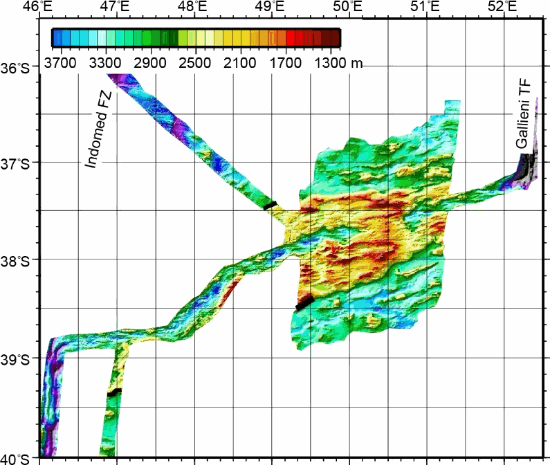
This grid was obtained by merging multibeam bathymetric data from several french cruises along the Southwest Indian Ridge from the Indomed to the Gallieni Transform Faults. The spatial resolution is about 150 m. This dataset was used in several scientific papers.
-
This dataset was recorded from 15th of April to 31st of July , 2011, by 10 autonomous, short-period (4.5 Hz) OBSs from Ifremer.
-
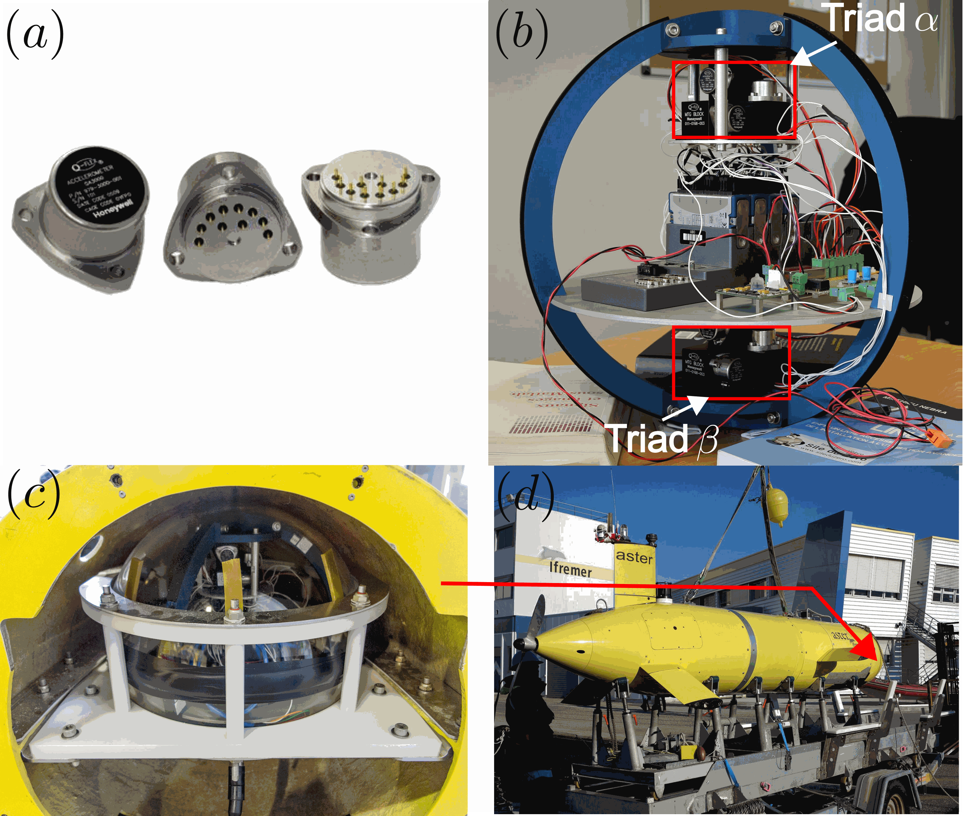
GraviMob-1 campaign is an underwater gravimetric survey conducted near the southern coast of France in the Mediterranean Sea in March 2016. The AUV Asterx was used to carry the GraviMob system. The operation was performed on board the vessel Europe. The data and processing results of this campaign are supporting the paper "High-resolution gravity measurement on board an Autonomous Underwater Vehicle: Data reduction and accuracy assessment". The dataset thus contains the following elements: 1. The raw data exported from GraviMob 2. The shipborne gravity data provided by SHOM 3. The processing results
-

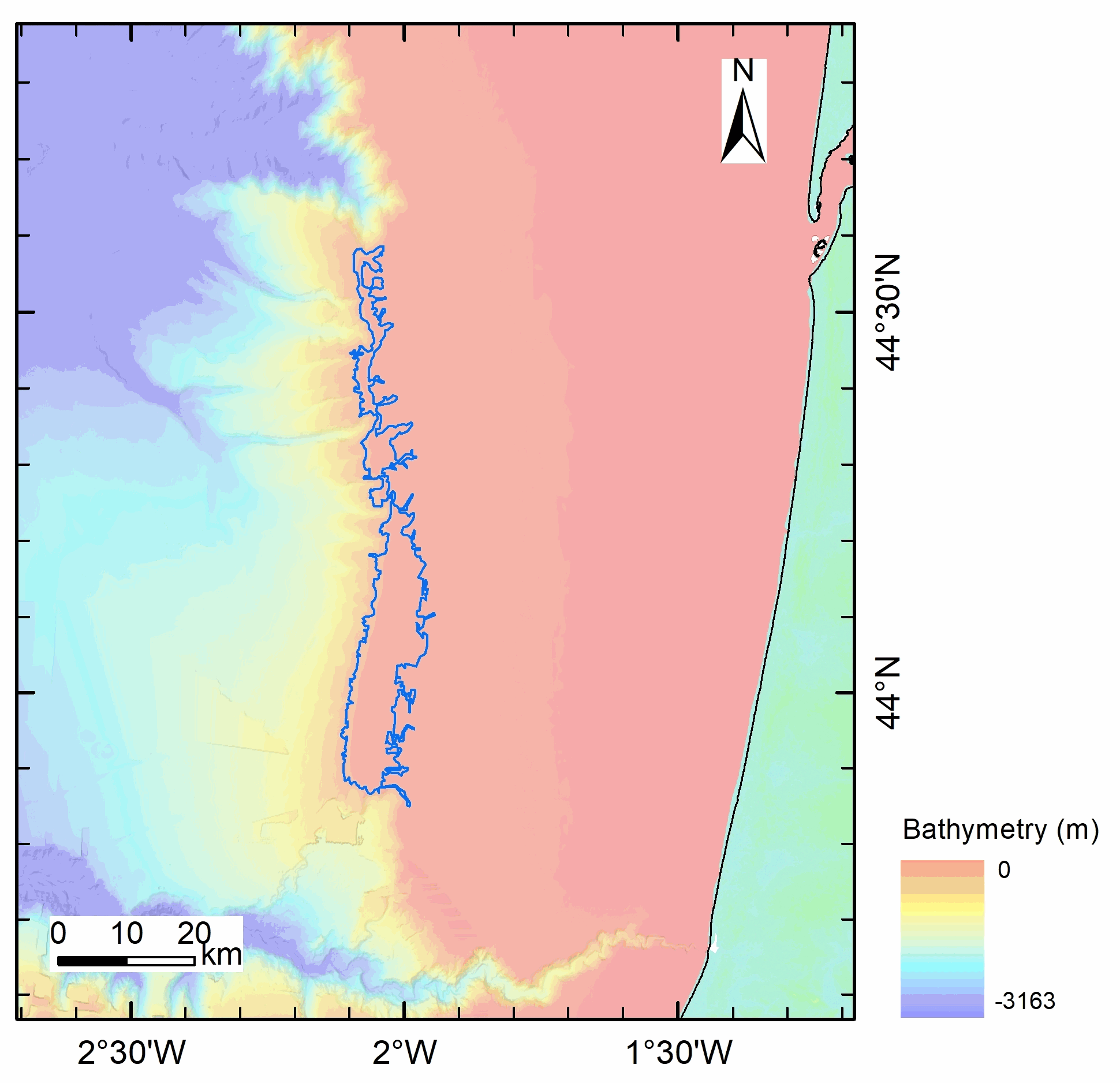
The data was collected during the survey NOMADS 09 (2009) conducted by the SHOM on the R/V Laplace. The bathymetry of the shelf edge and upper slope of the Moroccan Western Rifan continental Margin offshore the Spartel Headland (South of Gulf of Cadiz)) higtlights a field of NS trending kilometer-scale bathymetric ridges with elevation reaching more than 20m above surrounding seabed.
-

This seismic data set was recorded in September 2015 on board the R/V Pourquoi Pas? during the GHASS cruise (IFREMER) on the western Black Sea, offshore Romania. The available profiles (part of the collected data) within this deposit are located on the continental slope, bathymetry between 500 to 1200 meters. The pre-processing of the seismic data included common midpoint binning @6.25 meters, trace and shot edition, source delay correction, and a 35-375 Hz band pass filtering. Detailed Root Mean Square Velocity analyses were performed on semblance panels computed using super gathers every 150 m. Normal Move Out time correction was then applied on the Common Mid Point (CMP) using these velocities prior to stack. Interval velocities were computed using the Dix equation. The velocity model was then interpolated every CMP location, converted to depth and smoothed to perform post-stack depth migration. The depth migrated sections and the depth velocity models have been output to standard SEG-Y rev1 format (https://library.seg.org/pb-assets/technical-standards/seg_y_rev1-1686080991247.pdf) with values written using “big-endian” byte ordering and IEEE floating-point. For a given profile, both SEGY files have the same number of traces and the same bin locations. Velocity unit is in meter.second-1. The depth sampling is set to 0.5 meter for both files. The recording delay is zero for the depth migration SEGY files. The delay is coded in meters and constant for a given depth velocity SEGY file, stored within the Trace Header (bytes 109-110). Trace coordinates are also stored within the Trace Header using WGS84 +DDDMMSS.ss format with a scale factor of -100 (bytes 81-88, which means that the value has to divided by 100) . For more convenient access to the location of the profiles, these coordinates are also stored into ASCII files using decimal degrees.
-
Processed high resolution bathymetry acquired during the SERPENTINE, 2007 cruise of RV Pourquoi Pas?

High-resolution bathymetry data were acquired over three areas of the Mid-Atlantic Ridge, during three dives of ROV Victor 6000 SERPENTINE cruise onboard RV Pourquoi Pas?, using a RESON 7125 echosounder mounted on the ROV frame, with an operating frequencyof 400 kHz, a beam opening angle of 120°, a velocity of ~0.3 m/s, maintaining an altitude ~50 m above the seafloor and using ultra-short baseline ROV positioning. Data processing was conducted with the Caraibes 5.0 software (@Ifremer). The processed grids have a grid spacing of 0.5 m (Krasnov area), or 1m (Logatchev and Ashadze areas).