 Metadata catalogue
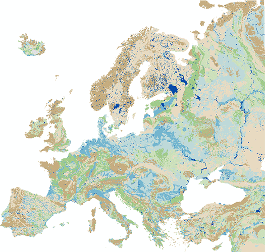
Lithology
Type of resources
Available actions
Topics
INSPIRE themes
Keywords
Contact for the resource
Provided by
Years
Formats
Representation types
Update frequencies
status
Service types
Scale
-
Jupiter is GEUS ' nationwide database for groundwater, drinking water, raw materials, environmental and geotechnical data. The database is the single public data base in the field and is included in the National Environmental Portal. The database is publicly available.
-
Note: This dataset is designed for the 1:50000 scale but can be viewed in this WMS between 1:100000 and 1:25000 (Only). The 1:50 000 DiGMapGB data covering the whole of the United Kingdom is available in this OGC WMS service for your personal, non-commercial use only. Separate bedrock geology, superficial deposits, artificial ground, mass movement deposits and geological linear features layers are available in this service. For information about more of the British Geological Survey's maps that are available digitally please visit http://www.bgs.ac.uk/products/digitalmaps/digmapgb.html.
-
EGDI 1:1 Million pan-european Surface Geology data built from harvested INSPIRE European WFS' for 1:1 Million Surface geology: geologic units. Based on data served as OneGeology and INSPIRE conformant services using INSPIRE Lithology and Geochronologic Era URI codelists.
-
EGDI 1:1M-scale surface Geologic Unit, Age and Lithology. European dataset harvested from national WFS for geologic units or national geological units datasets, based on OneGeology and INSPIRE Lithology and Geochronologic Era URI codelists.
-
The IHME1500 v1.2 is a vector dataset resulting from the digitisation of the 25 published map sheets of the International Hydrogeological Map of Europe at the of scale 1:1,500,000 (IHME1500). The dataset was extended for five unpublished, digitised IHME1500 map sheets to achieve full map coverage. It consists of selected features of the IHME1500 with the following content: - Aquifer types (area): Distinction of six types of aquifers according to their productivity and void types. - Lithology (area): Lithological classification of the aquifers at five aggregation levels. - Seawater intrusion (area): Areas with salination of groundwater caused by sea water intrusion. - Tectonic fractures (line): Geological lineaments assigned to the five classes of known or supposed faults or overthrusts and boundaries of fractured belts in Iceland. The IHME1500 v1.2 includes a correction of inconsistencies of the printed map sheets and was spatially adjusted to an up-to-date topographic base. The IHME1500 is a hydrogeological map series consisting of 25 published map sheets with explanatory notes that covers the European continent and parts of the Near East. The Federal Institute for Geosciences and Natural Resources (BGR) and the United Nations Educational, Scientific and Cultural Organization (UNESCO) are the project coordinators, supported by the International Association of Hydrogeologists (IAH) and the Commission for the Geological Map of the World (CGMW). Each sheet consists of contributions by the respective countries represented in the map, which were harmonised across borders. The map series including the explanatory notes can be used for scientific purposes, for large-scale regional planning and as a framework for detailed hydrogeological mapping.
-
The “Geological Map of Germany 1:1,000,000 OneGeology-Europe (GK1000-1GE)” shows Germany’s surface geology: All geological units are described by their age (stratigraphy) and composition (lithology). The geological units and terms used in this map were semantically harmonized within the OneGeology-Europe project and have been - in a number of regions - geometrically and semantically made consistent with the neighbouring OneGeology-Europe participants.
-
The IHME1500 v1.2 is a vector dataset resulting from the digitisation of the 25 published map sheets of the International Hydrogeological Map of Europe at the of scale 1:1,500,000 (IHME1500). The dataset was extended for five unpublished, digitised IHME1500 map sheets to achieve full map coverage. It consists of selected features of the IHME1500 with the following content: - Aquifer types (area): Distinction of six types of aquifers according to their productivity and void types. - Lithology (area): Lithological classification of the aquifers at five aggregation levels. - Seawater intrusion (area): Areas with salination of groundwater caused by sea water intrusion. - Tectonic fractures (line): Geological lineaments assigned to the five classes of known or supposed faults or overthrusts and boundaries of fractured belts in Iceland. The IHME1500 v1.2 includes a correction of inconsistencies of the printed map sheets and was spatially adjusted to an up-to-date topographic base. The IHME1500 is a hydrogeological map series consisting of 25 published map sheets with explanatory notes that covers the European continent and parts of the Near East. The Federal Institute for Geosciences and Natural Resources (BGR) and the United Nations Educational, Scientific and Cultural Organization (UNESCO) are the project coordinators, supported by the International Association of Hydrogeologists (IAH) and the Commission for the Geological Map of the World (CGMW). Each sheet consists of contributions by the respective countries represented in the map, which were harmonised across borders. The map series including the explanatory notes can be used for scientific purposes, for large-scale regional planning and as a framework for detailed hydrogeological mapping.
-

EMODnet Chemistry aims to provide access to marine chemistry data sets and derived data products concerning eutrophication, ocean acidification and contaminants. The chemicals chosen reflect importance to the Marine Strategy Framework Directive (MSFD). This regional aggregated dataset contains all unrestricted EMODnet Chemistry data on contaminants (49 parameters), and covers the Baltic Sea with 3818 CDI records divided per matrices: 1358 biota (396 Vertical profiles and 962 Time series),906 water profiles, 2510 sediment profiles. Vertical profiles temporal range is from 1985-04-16 to 2016-09-27. Time series temporal range is from 1972-05-02 to 2017-10-30. Data were aggregated and quality controlled by ‘Swedish Meteorological and Hydrological Institute (SMHI)’ from Sweden. Regional datasets concerning contaminants are automatically harvested. Parameter names in these datasets are based on P01, BODC Parameter Usage Vocabulary, which is available at: http://seadatanet.maris2.nl/bandit/browse_step.php . Each measurement value has a quality flag indicator. The resulting data collections for each Sea Basin are harmonised, and the collections are quality controlled by EMODnet Chemistry Regional Leaders using ODV Software and following a common methodology for all Sea Regions. Harmonisation means that: (1) unit conversion is carried out to express contaminant concentrations with a limited set of measurement units (according to EU directives 2013/39/UE; Comm. Dec. EU 2017/848) and (2) merging of variables described by different “local names” ,but corresponding exactly to the same concepts in BODC P01 vocabulary. The harmonised dataset can be downloaded as ODV spreadsheet (TXT file), which is composed of metadata header followed by tab separated values. This worksheet can be imported to ODV Software for visualisation (More information can be found at: https://www.seadatanet.org/Software/ODV ). The same dataset is offered also as XLSX file in a long/vertical format, in which each P01 measurement is a record line. Additionally, there are a series of columns that split P01 terms in subcomponents (measure, substance, CAS number, matrix...).This transposed format is more adapted to worksheet applications users (e.g. LibreOffice Calc). The 49 parameter names in this metadata record are based on P02, SeaDataNet Parameter Discovery Vocabulary, which is available at: http://seadatanet.maris2.nl/v_bodc_vocab_v2/vocab_relations.asp?lib=P02 . Detailed documentation will be published soon. The original datasets can be searched and downloaded from EMODnet Chemistry Download Service: https://emodnet-chemistry.maris.nl/search
-

EMODnet Chemistry aims to provide access to marine chemistry data sets and derived data products concerning eutrophication, ocean acidification and contaminants. The chemicals chosen reflect importance to the Marine Strategy Framework Directive (MSFD). This regional aggregated dataset contains all unrestricted EMODnet Chemistry data on contaminants (20 parameters), and covers the North East Atlantic Ocean with 2400 CDI records divided per matrices: 122 in biota (as time series), 1689 in water (as vertical profiles), 589 in sediment (478 Vertical profiles and 111 Time series). Vertical profiles temporal range is from 1970-07-29 to 2017-02-28. Time series temporal range is from 1979-02-28 to 2014-10-21. Data were aggregated and quality controlled by ‘IFREMER / IDM / SISMER - Scientific Information Systems for the SEA’ from France. Regional datasets concerning contaminants are automatically harvested. Parameter names in these datasets are based on P01, BODC Parameter Usage Vocabulary, which is available at: http://seadatanet.maris2.nl/bandit/browse_step.php . Each measurement value has a quality flag indicator. The resulting data collections for each Sea Basin are harmonised, and the collections are quality controlled by EMODnet Chemistry Regional Leaders using ODV Software and following a common methodology for all Sea Regions. Harmonisation means that: (1) unit conversion is carried out to express contaminant concentrations with a limited set of measurement units (according to EU directives 2013/39/UE; Comm. Dec. EU 2017/848) and (2) merging of variables described by different “local names” ,but corresponding exactly to the same concepts in BODC P01 vocabulary. The harmonised dataset can be downloaded as ODV spreadsheet (TXT file), which is composed of metadata header followed by tab separated values. This worksheet can be imported to ODV Software for visualisation (More information can be found at: https://www.seadatanet.org/Software/ODV ). The same dataset is offered also as XLSX file in a long/vertical format, in which each P01 measurement is a record line. Additionally, there are a series of columns that split P01 terms in subcomponents (measure, substance, CAS number, matrix...).This transposed format is more adapted to worksheet applications users (e.g. LibreOffice Calc). The 20 parameter names in this metadata record are based on P02, SeaDataNet Parameter Discovery Vocabulary, which is available at: http://seadatanet.maris2.nl/v_bodc_vocab_v2/vocab_relations.asp?lib=P02 . Detailed documentation will be published soon. The original datasets can be searched and downloaded from EMODnet Chemistry Download Service: https://emodnet-chemistry.maris.nl/search