 Metadata catalogue
Lithologie
Type of resources
Available actions
Topics
INSPIRE themes
Keywords
Contact for the resource
Provided by
Years
Formats
Representation types
status
Service types
Scale
-
Alluvions récents des cours d'eau principaux du Labourd (64) déterminés sur photographies aériennes par stéréographie.
-
Cartographie des formations miocènes et pliocènes basques issue de la carte harmonisée à 1/50000 modifiée par G. Karnay
-
Vectorisation des terrasses tracées sur carte IGN à 1/25000 par J.P. Platel lors d'une pré-étude pour la carte géologique.
-
Vectorisation des faciès lithologiques de la carte géologique de Razin (1989) à l'échelle 1/25 000.
-
Polygones limitant les sables littoraux tels qu'ils apparaissent sur les Orthophotos 2000.
-
Cartographie des altérites des Marno-calcaires à faciès flysch crétacés supérieurs.
-
Faciès géologiques du littoral de la Côte Basque calés sur les orthophotos 2000.
-
Carte des alluvions récentes issue des photo aériennes (Nivelle, Unxin, Grand Isaka) et de la carte harmonisée à 1/50000.
-
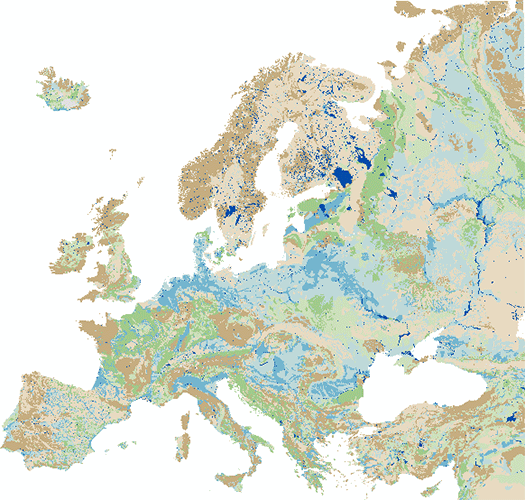
The IHME1500 v1.2 is a vector dataset resulting from the digitisation of the 25 published map sheets of the International Hydrogeological Map of Europe at the of scale 1:1,500,000 (IHME1500). The dataset was extended for five unpublished, digitised IHME1500 map sheets to achieve full map coverage. It consists of selected features of the IHME1500 with the following content: - Aquifer types (area): Distinction of six types of aquifers according to their productivity and void types. - Lithology (area): Lithological classification of the aquifers at five aggregation levels. - Seawater intrusion (area): Areas with salination of groundwater caused by sea water intrusion. - Tectonic fractures (line): Geological lineaments assigned to the five classes of known or supposed faults or overthrusts and boundaries of fractured belts in Iceland. The IHME1500 v1.2 includes a correction of inconsistencies of the printed map sheets and was spatially adjusted to an up-to-date topographic base. The IHME1500 is a hydrogeological map series consisting of 25 published map sheets with explanatory notes that covers the European continent and parts of the Near East. The Federal Institute for Geosciences and Natural Resources (BGR) and the United Nations Educational, Scientific and Cultural Organization (UNESCO) are the project coordinators, supported by the International Association of Hydrogeologists (IAH) and the Commission for the Geological Map of the World (CGMW). Each sheet consists of contributions by the respective countries represented in the map, which were harmonised across borders. The map series including the explanatory notes can be used for scientific purposes, for large-scale regional planning and as a framework for detailed hydrogeological mapping.
-
The “Geological Map of Germany 1:1,000,000 OneGeology-Europe (GK1000-1GE)” shows Germany’s surface geology: All geological units are described by their age (stratigraphy) and composition (lithology). The geological units and terms used in this map were semantically harmonized within the OneGeology-Europe project and have been - in a number of regions - geometrically and semantically made consistent with the neighbouring OneGeology-Europe participants.