 Metadata catalogue
INFOMAR, EMODnet Bathymetry, InisHydro, CHERISH
Type of resources
Available actions
Topics
Keywords
Contact for the resource
Provided by
Years
Formats
Representation types
Update frequencies
status
Scale
-
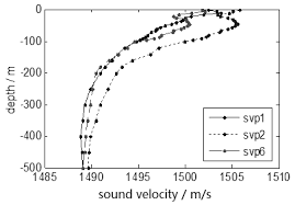
The INtegrated Mapping FOr the Sustainable Development of Ireland's MArine Resource (INFOMAR) programme is a joint venture between the Geological Survey of Ireland (GSI) and the Marine Institute (MI). The programme is the successor to the Irish National Seabed Survey (INSS) and concentrates on creating integrated mapping products related to the seabed. A sound velocity profile shows the speed of sound in water at different vertical levels. It has two general representations: 1. tabular form, with pairs of columns corresponding to ocean depth and the speed of sound at that depth, respectively. 2. a plot of the speed of sound in the ocean as a function of depth, where the vertical axis corresponds to the depth and the horizontal axis corresponds to the sound speed. By convention, the horizontal axis is placed at the top of the plot, and the vertical axis is labeled with values which increase from top to bottom, thus reproducing visually the ocean from its surface downward. A Sound Velocity Profile (SVP) is a measurement of the speed of sound in water. SVP data is collected during multi-beam surveying for calibration purposes to ground-truth the bathymetric and backscatter data collection. Data for SVP point locations and associated attribute values is generated from SVP profiler during survey. Data includes XY Longitude Latitude, Start SVP, End SVP, Maximum Depth, Data Quality and Comments, SVP Instrument Name and Survey Leg name.
-
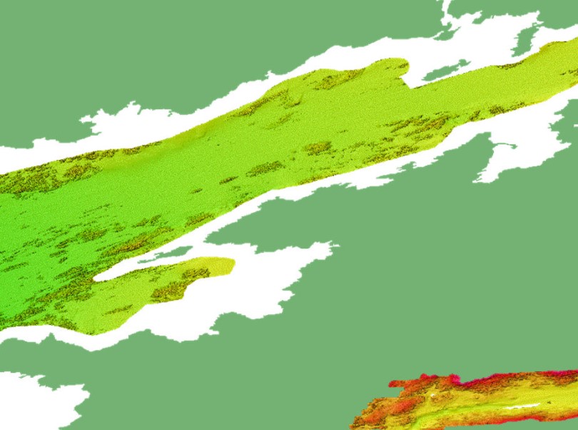
The INtegrated Mapping FOr the Sustainable Development of Ireland's MArine Resource (INFOMAR) programme is a joint venture between the Geological Survey of Ireland (GSI) and the Marine Institute (MI). The programme is the successor to the Irish National Seabed Survey (INSS) and concentrates on creating integrated mapping products related to the seabed. INFOMAR Seabed Samples Particle Size Analysis represent locations where samples have been taken and particle size analysis (PSA) carried out on samples. Sediment type classification based on percentage sand, mud and gravel (after Folk 1954). Every sediment is a mixture of grains of varying sizes. It groups grains into mud, sand and gravel on the basis of their diameter. The relative proportion of the grains in the three categories is then used to describe the sediment and is displayed in a diagram commonly called a “Folk triangle”. This classification has 15 terms to describe the seabed sediments. Samples from the seabed are taken by grab and box core sampling instruments. PSA is applied to determine the range of sediment sizes contained in the sample which can often reveal an insight about the processes operating in the depositional environment. The results show percentage gravels, sands, silt and mud present in the sample. This analysis is also used to determine if the sample is well or poorly sorted.