 Metadata catalogue
Hydrogeology
Type of resources
Available actions
Topics
INSPIRE themes
Keywords
Contact for the resource
Provided by
Years
Formats
Representation types
Update frequencies
status
Service types
Scale
-

Il servizio permette la visualizzazione di alcune Carte Idrogeologiche a diversa scala di risoluzione realizzate pro-parte in collaborazione con ISPRA - Servizio Geologico d'Italia. Il servizio dispone delle seguenti cartografie: Carta delle manifestazioni termali e dei complessi idrogeologici d'Italia alla scala 1:1.000.000; Carta idrogeologica regionale per la ricerca sulla vulnerabilità naturale e sul rischio di inquinamento delle acque sotterranee della Pianura Padana e Veneto-Friulana alla scala 1:500.000; Carta dello schema Idrogeologico dell'Italia centrale alla scala 1:500.000; Carta idrogeologica dell'Italia meridionale alla scala 1:250.000 e arta idrogeologica schematica del Piemonte (NW Italia) alla scala 1:250.000.
-
The hydrogeological map indicates aquifer potential in generalised terms using a threefold division of geological formations: those in which intergranular flow in the saturated zone is dominant, those in which flow is controlled by fissures or discontinuities and less permeable formations including aquifers concealed at depth beneath covering layers. Highly productive aquifers are distinguished from those that are only of local importance or have no significant groundwater. Within each of these classes the strata are grouped together according to age or lithology. The 1:625 000 scale data may be used as a guide to the aquifers at a regional or national level, but should not be relied on for local information.
-
The map shows the potential for the rocks to supply groundwater and the type of groundwater flow within the rocks. The dataset reattributes polygons in the Digital Geological Map Data of Great Britain - 625k (DiGMapGB-625) Bedrock version 5 dataset to indicate whether the bedrock is an aquifer, the type of flow through the aquifer (fracture and fissure flow or intergranular flow) and how productive the aquifer is likely to be. The dataset is based on the known hydrogeological properties of rock types. The dataset covers just the bedrock formations for the UK and the Isle of Man. The data can be used for planning, environmental analysis, water supply and hazards.
-
This layer of the map based index (GeoIndex) shows the location of available Hydrogeological Maps which have been published at various scales, covering areas ranging in size from the whole of England and Wales, Northern Ireland and to Jersey. They display information on surface water features, the three dimensional geometry of aquifers, groundwater levels, abstractions and quality including saline intrusion in varying amounts of detail.
-
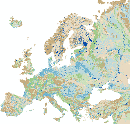
The IHME1500 v1.2 is a vector dataset resulting from the digitisation of the 25 published map sheets of the International Hydrogeological Map of Europe at the of scale 1:1,500,000 (IHME1500). The dataset was extended for five unpublished, digitised IHME1500 map sheets to achieve full map coverage. It consists of selected features of the IHME1500 with the following content: - Aquifer types (area): Distinction of six types of aquifers according to their productivity and void types. - Lithology (area): Lithological classification of the aquifers at five aggregation levels. - Seawater intrusion (area): Areas with salination of groundwater caused by sea water intrusion. - Tectonic fractures (line): Geological lineaments assigned to the five classes of known or supposed faults or overthrusts and boundaries of fractured belts in Iceland. The IHME1500 v1.2 includes a correction of inconsistencies of the printed map sheets and was spatially adjusted to an up-to-date topographic base. The IHME1500 is a hydrogeological map series consisting of 25 published map sheets with explanatory notes that covers the European continent and parts of the Near East. The Federal Institute for Geosciences and Natural Resources (BGR) and the United Nations Educational, Scientific and Cultural Organization (UNESCO) are the project coordinators, supported by the International Association of Hydrogeologists (IAH) and the Commission for the Geological Map of the World (CGMW). Each sheet consists of contributions by the respective countries represented in the map, which were harmonised across borders. The map series including the explanatory notes can be used for scientific purposes, for large-scale regional planning and as a framework for detailed hydrogeological mapping.