 Metadata catalogue
Geowissenschaften
Type of resources
Available actions
Topics
INSPIRE themes
Keywords
Contact for the resource
Provided by
Years
Formats
Representation types
Update frequencies
status
Service types
Scale
-
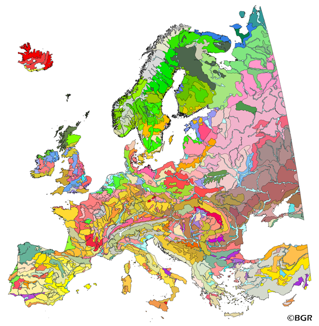
The map of the "Soil Regions of the European Union and Adjacent Countries 1:5,000,000 (Version 2.0)" is published by the Federal Institute of Geosciences and Natural Resources (BGR), in partnership with the Joint Research Center (JRC, Ispra). The soil regions map is intended to support the current national mapping activities towards a European 1:250,000 datbase by stratifying similar regional soil associations into a hierarchical concept. Only by stratification, the complexity of soils can be systematically structured so that the complex 1:250,000 legend can be handled in cross-national and contintental-level applications. Soil regions are natural, cross-regional soil geographical units which perform the highest spatial and content-based aggregation of European soils. They represent the frame conditions for soil development at the landscape level. The soil regions are presented at scale 1:5,000,000. Thus, its borders are highly generalized. Because of its low resolution, the map units absorb atypical soils and associations of soils, which are only described in higher resolution soil maps. The delineation of the soil regions is expected to be refined (and probably improved by its content) during the actual 1:250,000 mapping process. Thus, updating can be expected in the future. Currently, the soil regions map is the only graphical soil representation in Europe which has been developed using fully comparable and harmonized basic data at the continental level (climate, hydrography, relief, geology, vegetation): the interpretation of this input data, and the utilization of expert knowledge (including the interpretation of regional soil maps) has been done using one common methodology, developed and applied consistently throughout the whole mapping area by an experienced international soil mapper (Dr. Reinhard Hartwich, former member of BGR, and co-author of the 1998 Manual of Procedures). The methodology is extensively described in the Explanatory Notes (German), and in the revised Manual of Procedures which is expected to be completed soon. It is highly recommended to apply and interpret the map using the map comments and descriptions as provided in the explanatory notes (German: Hartwich et al. 2005; English: revision of the Manual of Procedures, initial version: Finke et al. 2001).
-
The “Geological Map of Germany 1:1,000,000 OneGeology-Europe (GK1000-1GE)” shows Germany’s surface geology: All geological units are described by their age (stratigraphy) and composition (lithology). The geological units and terms used in this map were semantically harmonized within the OneGeology-Europe project and have been - in a number of regions - geometrically and semantically made consistent with the neighbouring OneGeology-Europe participants.
-
.png)
The GK1000 (INSPIRE) represents the surface geology of Germany and adjacent areas on a scale of 1:1,000,000. According to the Data Specification on Geology (D2.8.II.4_v3.0) the content of the geological map is stored in three INSPIRE-compliant GML files: GK1000_GeologicUnit.gml contains the geologic units, GK1000_GeologicStructure.gml comprises the faults and GK1000_NaturalGeomorphologicFeature.gml represents the marginal position of the ice shield. The GML files together with a Readme.txt file are provided in ZIP format (GK1000-INSPIRE.zip). The Readme.text file (German/English) contains detailed information on the GML files content. Data transformation was proceeded by using the INSPIRE Solution Pack for FME according to the INSPIRE requirements.
-
The GEOCR500 dataset was processed completely digitally in ArcGIS 9.1 and integrated within a regional geographic information system.
-
The GEOBG500 dataset was created in 1995 by digitizing the paper version of the Geological map of Bulgaria at a scale of 1:500 000, that was published in 1989. This consists of 2 flat coloured sheets covered the whole territory of Bulgaria. The map has been produced in a combined Bulgarian-English edition and was compiled using the Geological Map of Bulgaria at a scale of 1:100 000 as a base, combined with data from the National Geofund. The dataset is digitally integrated and available in MapInfo format.
-
A dataset used to display the intrinsic geological and hydrogeological characteristics that determine the ease with which groundwater may be contaminated by human activities.
-
The GEOBG100 dataset was created during the period 1995-1997 by digitizing the paper version of the Geological map of Bulgaria at a scale of 1:100 000. This consists of 86 coloured flat sheets, covering the whole onshore territory of the country. The map is available in a Bulgarian or in an English edition. The dataset is digitally integrated and available in MapInfo and ArcGIS formats.
-
REGIS stands for REgionaal Geohydrologisch InformatieSysteem, which is the National hydro-geological model for the Netherlands. Version II.1 is an extension and revision of the hydro-geological model version II.0 (REGIS II). REGIS has been developed by TNO, the Geological Survey of the Netherlands in cooperation with RIZA (the national water office) and the Provincial authorities. The hydro-geological model is a digital model of the upper part of the Dutch subsurface to a depth of approximately 500 meters. Using ESRI grids and shapefiles, the model shows the depth, thickness and hydraulic properties of hydro-geological units as well as the location of faults. A hydro-geological unit is a unit defined using texture, structure and soil type having (more or less) uniform hydrogeological properties bounded by facies-layers, erosion boundaries and faults. The hydrogeological model is based on the Digital Geological Model (DGM) and the shallow subsurface lithostratigraphical Nomenclature version 1.0 which is available through www.dinoloket.nl
-
The map of Quaternary deposits of Finland at 1:1 000 000 scale depicts the main features of the Quaternary geology of Finland. The dataset consists of areas defined according to deposit type and genesis.
-
REGIS stands for REgionaal Geohydrologisch InformatieSysteem, which is the National hydro-geological model for the Netherlands. Version II.1 is an extension and revision of the hydro-geological model version II.0 (REGIS II). REGIS has been developed by TNO, the Geological Survey of the Netherlands in cooperation with RIZA (the national water office) and the Provincial authorities. The hydro-geological model is a digital model of the upper part of the Dutch subsurface to a depth of approximately 500 meters. Using ESRI grids and shapefiles, the model shows the depth, thickness and hydraulic properties of hydro-geological units as well as the location of faults. A hydro-geological unit is a unit defined using texture, structure and soil type having (more or less) uniform hydrogeological properties bounded by facies-layers, erosion boundaries and faults. The hydrogeological model is based on the Digital Geological Model (DGM) and the shallow subsurface lithostratigraphical Nomenclature version 1.0 which is available through www.dinoloket.nl