 Metadata catalogue
Geophysics
Type of resources
Available actions
Topics
INSPIRE themes
Keywords
Contact for the resource
Provided by
Years
Formats
Representation types
Update frequencies
status
Service types
Scale
Resolution
-
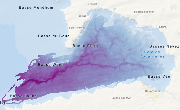
Jeu de données raster correspondant à la "Carte morpho-bathymétrie du substratum rocheux de la baie de Douarnenez", éditée en 2005 dans l'atlas thématique de l'environnement marin de la baie de Douarnenez. Campagne océanographique à l'origine du jeu de données : - AUGRIS Claude, NORMAND Alain (2000) CANADOU cruise, RV Thalia, https://doi.org/10.17600/70020 Références bibliographiques : - AUGRIS C., MENESGUEN A., HAMON D., BLANCHET A., LE ROY P., ROLET J., JOUET G., VERON G., DELANNOY H., DROGOU M., BERNARD C., MAILLARD X. (2005), Atlas thématique de l'environnement marin de la baie de Douarnenez (Finistère). 10 cartes, échelle 1/25 000 et un livret d'accompagnement, 135 p. Ed. Ifremer - Ville de Douarnenez. - Jouet, G., Augris, C., Hallegouët, B., Le Roy, P., Rolet, J., 2003. La vallée d'Ys : un paléoréseau hydrographique immergé en Baie de Douarnenez (Finistère, France). Comptes Rendus Geoscience 335, 487-494.
-

Scan géoréférencé de la "Carte morpho-bathymétrie du substratum rocheux de la baie de Douarnenez", éditée en 2005 dans l'atlas thématique de l'environnement marin de la baie de Douarnenez. Campagne océanographique à l'origine du jeu de données : - AUGRIS Claude, NORMAND Alain (2000) CANADOU cruise, RV Thalia, https://doi.org/10.17600/70020 Référence bibliographique : AUGRIS C., MENESGUEN A., HAMON D., BLANCHET A., LE ROY P., ROLET J., JOUET G., VERON G., DELANNOY H., DROGOU M., BERNARD C., MAILLARD X. (2005), Atlas thématique de l'environnement marin de la baie de Douarnenez (Finistère). 10 cartes, échelle 1/25 000 et un livret d'accompagnement, 135 p. Ed. Ifremer - Ville de Douarnenez.
-
This low-resolution image has been produced from BGS airborne and marine magnetic data. The colour was generated using the BGS COLMAP software package. Colour levels are defined by histogram equalisation. Combining this image with the grey shaded relief image produces a similar image to the colour shaded relief image. A published coloured shaded relief map, using the full resolution of the data and produced at a scale of 1: 1500 000, is available. The map covers a larger area than this image, and includes additional data from other sources. The data used to compile this image are available in various forms for academic and commercial licensing. The data from surveys covering the UK mainland have been digitised from their original analogue form. Elsewhere data were acquired digitally. Standard methods of processing were used to remove diurnal and secular variations and to minimise line intersection errors. While efforts have been made to remove artefacts from the data, some may remain between adjacent datasets. Generally anomalies over man-made structures have not been removed. The data have been interpolated onto a 1km x 1km grid using a variable tension technique, and smoothed.
-
Relative superconducting gravimeter OSG-050 manufactured by GWR Instruments, Inc. USA. It provides continuous measurement of gravity variations with sampling rate of 1 sec at the gravimetric station Pecny since 2007. Data are distribued to IGETS (International Geodynamics and Earth Tide Service).
-
Repeated measurements of gravity acceleration at five absolute gravity stations in the Czech Republic have been carried out by absolute gravimeters FG5 No. 215 and FG5X No. 251 manufactured by Micro-g LaCoste, Inc. USA. Data are distributed to AGrav database.
-
An index to over 600 ground geophysical surveys carried out in the UK for a variety of projects. A large number of these surveys were done in conjunction with the DTI Mineral Reconnaissance Programme in the 1970's and 80's, and many others were carried out at the request of BGS field mapping groups. Information held describes the survey objective, location of measurements, geophysical methods and equipment used, reports and publications, storage locations of data and results (for analogue and digital data), dates and personnel. There are two datasets; one shows the outline of the survey areas, and the other shows the actual survey lines within each area.
-
This layer of the map based index (GeoIndex) shows the path the survey ship took whilst undertaking the ship gravity, magnetic and bathymetry survey. This index is based on data from approximately 350,000 line kilometres of multi-instrument geophysical survey lines. The data itself includes seismic, sonar, magnetic, gravity, echo sounder, multibeam bathymetry and navigation data, both in digital and analogue format. The data were primarily collected by BGS and the collection also includes additional third party data.
-
The UK Onshore Geophysical Library was established in 1994 in conjunction with the Department of Trade and Industry (DTI) and the UK Onshore Operators Group (UKOOG). The Library manages the archive and official release of seismic data recorded over landward areas of the UK. By agreement with the DTI and HMSO, the Library operates as a registered charity, funded by revenues raised from data sales and donations, with the long term objective of bringing all available UK onshore digital seismic data into secure archival storage, whilst providing efficient access to all interested parties. BGS has access to the data at cost of copying only for science budget work. Data index on the BGS Geoscience Data Index.
-
This layer of the map based index (GeoIndex) shows the location of onshore UK boreholes known to BGS that have digital or paper geophysical borehole logs. The details given for each borehole are, the name of the borehole, the grid reference and the format, ie. paper or digital. Scattered distribution of boreholes, locally dense coverage, few logs from Scotland. The GeoIndex is updated at regular intervals but more information may be available than is shown at any one time.
-
Parent metadata record of national datasets containing spatial features of type Vertical Electric Sounding. Metadata is used to look up datasets and services contributing to the the Annex II Geology theme INSPIRE layer officially titled as GE.VericalElectricSounding.