 Metadata catalogue
GIS
Type of resources
Available actions
Topics
Keywords
Contact for the resource
Provided by
Years
Formats
Representation types
Update frequencies
status
Service types
Scale
-
This service is an INSPIRE download WFS service, providing UK onshore bedrock geological data at 1:625 000 scale. This map data is collected as part of an ongoing BGS project: Digital Geological Map of Great Britain (DiGMapGB). GeoServer software is used to provide this WFS service. This service is delivering MappedFeatures specified by GeologicUnits, the geological history of which is recorded by GeologicEvents.
-
The 1:50 000 scale GeoSure (natural ground stability) data covering the map sheets for Loughborough and Kilmarnock are available in this OGC WMS service for personal, non-commercial use only. This service is a contribution to the OneGeology-Europe initiative. For information about more of the British Geological Survey's maps and other digital products please visit http://www.bgs.ac.uk/products. MapServer software is used to provide this OGC WMS service.
-
This service is the BGS contribution to the OneGeology project, providing UK onshore geological data at 1:625 000 scale and UK continental shelf seabed sediment data at 1:1 million scale. This map data is collected as part of an ongoing BGS project: Digital Geological Map of Great Britain (DiGMapGB). MapServer software is used to provide these OGC WMS and WFS services.
-
This data layer is the BGS contribution to the OneGeology project, providing UK onshore geological data at 1:625 000 scale and UK continental shelf seabed sediment data at 1:1 million scale. This map data is collected as part of an ongoing BGS project: Digital Geological Map of Great Britain (DiGMapGB). This layer is the seabed sediment data layer.
-
Data identifying landscape areas (shown as polygons) attributed with geological names and rock type descriptions. The scale of the data is 1:625 000 scale providing a simplified interpretation of the geology. Onshore coverage is provided for all of England, Wales, Scotland, the Isle of Man and Northern Ireland. Bedrock geology describes the main mass of solid rocks forming the earth's crust. Bedrock is present everywhere, whether exposed at surface in outcrops or concealed beneath superficial deposits or water bodies. The bedrock geology of the UK is very diverse and includes three broad classes based on their mode of origin: igneous, metamorphic and sedimentary. The data includes attribution to identify each rock type (in varying levels of detail) as described in the BGS Rock Classification Scheme (volumes 1-3 ). The bedrock has formed over long periods of geological time, from the Archean eon some 7500 million years ago, to the relatively young Pliocene, 58 million years ago. The age of the rocks is identified in the data through their BGS lexicon name (published for each deposit at the time of the original survey or subsequent digital data creation). For stratified rocks i.e. arranged in sequence, this will usually be of a lithostratigraphic type. Other rock types for example intrusive igneous bodies will be of a lithodemic type. More information on the formal naming of UK rocks is available in the BGS Lexicon of Named Rock Units. Geological names are based on the lithostratigraphic or lithodemic hierarchy. The lithostratigraphic scheme arranges rock bodies into units based on rock-type and geological time of formation. Where rock-types do not fit into the lithostratigraphic scheme, for example intrusive, deformed rocks subjected to heat and pressure resulting in new or changed rock types; then their classification is based on their rock-type or lithological composition using visible features such as texture, structure, mineralogy. The data are available in vector format (containing the geometry of each feature linked to a database record describing their attributes) as ESRI shapefiles and are delivered free of charge under the terms of the Open Government Licence.
-
Data identifying landscape areas (shown as polygons) attributed with geological names. The scale of the data is 1:250 000 scale providing a generalised geology. Onshore coverage is provided for all of England, Wales, Scotland and the Isle of Man. Data are supplied as two themes: bedrock and linear features (faults), there is no superficial, mass movement or artificial theme available onshore at this scale. Bedrock geology describes the main mass of solid rocks forming the earth's crust. Bedrock is present everywhere, whether exposed at surface in outcrops or concealed beneath superficial deposits or water bodies. Geological names are based on the lithostratigraphic or lithodemic hierarchy. This means rock bodies are arranged into units based on rock-type and geological time of formation. Where rock-types do not fit into the lithostratigraphic scheme, for example intrusive, deformed rocks subjected to heat and pressure resulting in new or changed rock types; then their classification is based on their rock-type or lithological composition. This assesses visible features such as texture, structure, mineralogy. Data identifying linear features (shown as polylines) represent geological faults at the ground or bedrock surface (beneath superficial deposits). Geological faults occur where a body of bedrock has been fractured and displaced by large scale processes affecting the earth's crust (tectonic forces). The faults theme defines geological faults (shown as polylines) at the ground or bedrock surface (beneath superficial deposits). The data are available in vector format (containing the geometry of each feature linked to a database record describing their attributes) as ESRI shapefiles and are available under BGS data licence.
-
Data identifying landscape areas (shown as polygons) attributed with geological names. The scale of the data is 1:625 000 providing a simplified interpretation of the geology. Onshore coverage is provided for all of England, Wales, Scotland, the Isle of Man and Northern Ireland. Data are supplied as four themes: bedrock, superficial deposits, dykes and linear features (faults). Bedrock geology describes the main mass of solid rocks forming the earth's crust. Bedrock is present everywhere, whether exposed at surface in outcrops or concealed beneath superficial deposits or water bodies. Geological names are based on the lithostratigraphic or lithodemic hierarchy of the rocks. The lithostratigraphic scheme arranges rock bodies into units based on rock-type and geological time of formation. Where rock-types do not fit into the lithostratigraphic scheme, for example intrusive, deformed rocks subjected to heat and pressure resulting in new or changed rock types; then their classification is based on their rock-type or lithological composition. This assesses visible features such as texture, structure, mineralogy. Superficial deposits are younger geological deposits formed during the most recent geological time; the Quaternary. These deposits rest on older rocks or deposits referred to as bedrock. The superficial deposits theme defines landscape areas (shown as polygons) attributed with a geological name and their deposit-type or lithological composition. The dykes theme defines small, narrow areas (shown as polygons) of a specific type of bedrock geology; that is igneous rocks which have been intruded into the landscape at a later date than the surrounding bedrock. They are presented as an optional, separate theme in order to provide additional clarity of the bedrock theme. The bedrock and dykes themes are designed to be used together. Linear features data (shown as polylines) represents geological faults at the ground or bedrock surface (beneath superficial deposits). Geological faults occur where a body of bedrock has been fractured and displaced by large scale processes affecting the earth's crust (tectonic forces). The faults theme defines geological faults (shown as polylines) at the ground or bedrock surface (beneath superficial deposits). All four data themes are available in vector format (containing the geometry of each feature linked to a database record describing their attributes) as ESRI shapefiles and are delivered free of charge under the terms of the Open Government Licence.
-

SRID 900913 of two available coordinate systems. Data of high resolution (10kmx10km) Direct Normal Irradiance (DNI) for the years 2000, 2002 and 2003. The data are available for monthly and annual sums stored in a ESRI-Shapefile. Please read the country report for additional background information. Data included for Bangladesh, China, Ethiopia, Ghana, Kenya, Nepal, Sri Lanka, and United Arab Emirates. Units: KWh/m sq. per day. Source: DLR - Deutsches Zentrum für Luft- und Raumfahrt
-
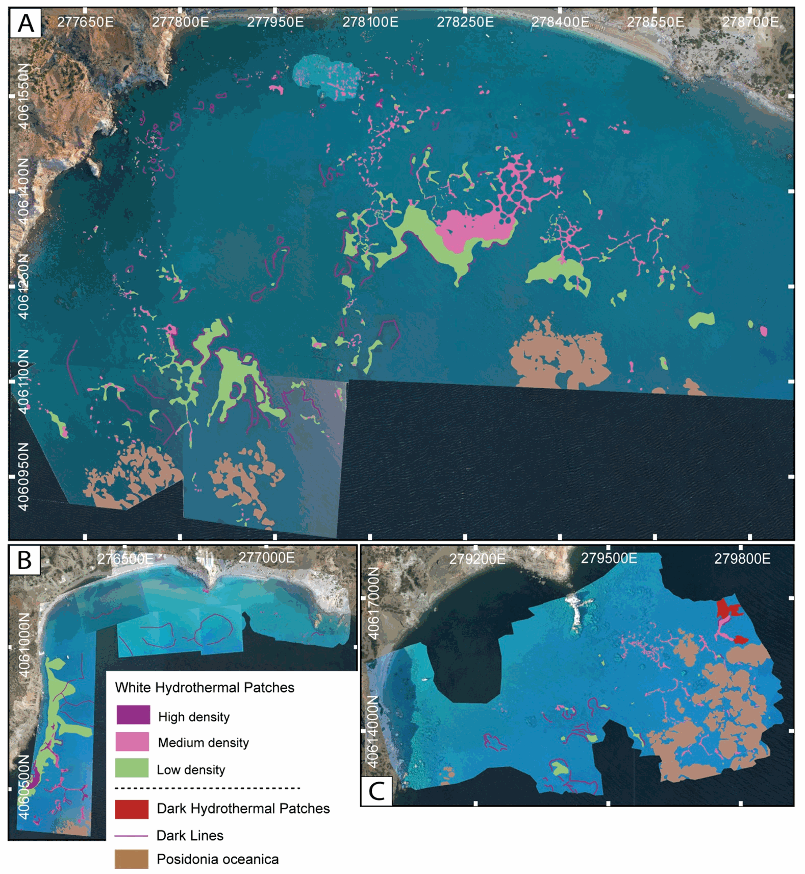
This dataset inscludes shapefiles interpreted from photomosaics over the Milos shallow water hydrothermal system, and instrument locaitons, from fieldwork in July and September 2019. The shapefiles are organized by study areas (Agia Kyria, Paleochori, and Spathi bays). Details are provided in the associated paper (Puzenat et al., 2021) in addition to information in the Readme File associated. a) Shapefiles of seafloor textures interpreted from drone imagery. b) Shapefiles of seafloor texttures interpreted from AUV imagery. c) Shapefiles of instruments deployed in the study area in September 2019.
-
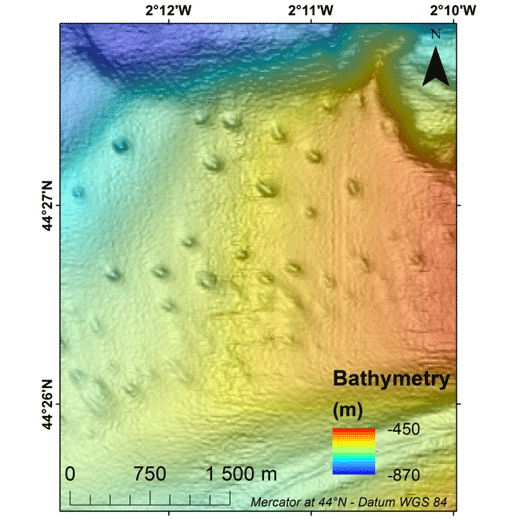
Pockmarks are defined as depressions on the seabed and are usually formed by fluid expulsions. Recently discovered, pockmarks along the Aquitaine slope within the French EEZ, were manually mapped although two semi-automated methods were tested without convincing results. In order to potentially highlight different groups and possibly discriminate the nature of the fluids involved in their formation and evolution, a morphological study was conducted, mainly based on multibeam data and in particular bathymetry from the marine expedition GAZCOGNE1, 2013. Bathymetry and seafloor backscatter data, covering more than 3200 km², were acquired with the Kongsberg EM302 ship-borne multibeam echosounder of the R/V Le Suroît at a speed of ~8 knots, operated at a frequency of 30 kHz and calibrated with ©Sippican shots. Precision of seafloor backscatter amplitude is +/- 1 dB. Multibeam data, processed using Caraibes (©IFREMER), were gridded at 15x15 m and down to 10x10 m cells, for bathymetry and seafloor backscatter, respectively. The present table includes 11 morphological attributes extracted from a Geographical Information System project (Mercator 44°N conserved latitude in WGS84 Datum) and additional parameters related to seafloor backscatter amplitudes. Pockmark occurrence with regards to the different morphological domains is derived from a morphological analysis manually performed and based on GAZCOGNE1 and BOBGEO2 bathymetric datasets. The pockmark area and its perimeter were calculated with the “Calculate Geometry” tool of Arcmap 10.2 (©ESRI) (https://desktop.arcgis.com/en/arcmap/10.3/manage-data/tables/calculating-area-length-and-other-geometric-properties.htm). A first method to calculate pockmark internal depth developed by Gafeira et al. was tested (Gafeira J, Long D, Diaz-Doce D (2012) Semi-automated characterisation of seabed pockmarks in the central North Sea. Near Surface Geophysics 10 (4):303-315, doi:10.3997/1873-0604.2012018). This method is based on the “Fill” function from the Hydrology toolset in Spatial Analyst Toolbox Arcmap 10.2 (©ESRI), (https://pro.arcgis.com/en/pro-app/tool-reference/spatial-analyst/fill.htm) which fills the closed depressions. The difference between filled bathymetry and initial bathymetry produces a raster grid only highlighting filled depressions. Thus, only the maximum filling values which correspond to the internal depths at the apex of the pockmark were extracted. For the second method, the internal pockmark depth was calculated with the difference between minimum and maximum bathymetry within the pockmark. Latitude and longitude of the pockmark centroid, minor and major axis lengths and major axis direction of the pockmarks were calculated inside each depression with the “Zonal Geometry as Table” tool from Spatial Analyst Toolbox in ArcGIS 10.2 (©ESRI) (https://pro.arcgis.com/en/pro-app/tool-reference/spatial-analyst/zonal-statistics.htm). Pockmark elongation was calculated as the ratio between the major and minor axis length. Cell count is the number of cells used inside each pockmark to calculate statistics (https://pro.arcgis.com/en/pro-app/tool-reference/spatial-analyst/zonal-geometry.htm). Cell count and minimum, maximum and mean bathymetry, slope and seafloor backscatter values were calculated within each pockmark with “Zonal Statistics as Table” tool from Spatial Analyst Toolbox in ArcGIS 10.2 (©ESRI). Slope was calculated from bathymetry with “Slope” function from Spatial Analyst Toolbox in ArcGIS 10.2 (©ESRI) and preserves its 15 m grid size (https://pro.arcgis.com/en/pro-app/tool-reference/spatial-analyst/slope.htm). Seafloor backscatter amplitudes (minimum, maximum and mean values) of the surrounding sediments were calculated within a 100 m buffer around the pockmark rim.