 Metadata catalogue
Fisheries and aquaculture
Type of resources
Available actions
Topics
INSPIRE themes
Keywords
Contact for the resource
Provided by
Years
Formats
Representation types
Update frequencies
Resolution
-
Fishing for razor clams (Ensis spp.) within the Scottish zone is prohibited. For a trial period, Marine Scotland will authorise (under Article 43 of EC Regulation No. 850/1998 and article 4(2) of Scottish SI 2017 No. 419) electrofishing for razor clams (Ensis spp.) in certain areas around Scotland for scientific research.
-
These layers are the outputs of research which developed a national river temperature model for Scotland capable of predicting both daily maximum river temperature and sensitivity to climate change. The layers show the following: summer_max_tw_2015_16 – Predictions of maximum daily river temperatures for the hottest day between July 2015 and June 2016. summer_max_tw_2003 – Predictions of maximum daily river temperatures for the hottest year in the last 20 years (2003). summer_climate_change_sensitivity – Predictions of the change in river temperature that would result from a 1°C increase in air temperature. A fourth layer has been developed to combine the outputs from “summer_max_tw_2003” and “summer_climate_change_sensitivity” into a single layer that can be used to prioritise management where the relative importance of maximum temperature and temperature change are considered to be equal. This was achieved by (1) dividing the predictions of ‘summer_max_tw_2003’ and ‘summer_climate_change_sensitivity’ into 5 equal categories between the minimum and maximum observed values (2) assigning these categories a value ranging from 1 (the hottest / most sensitive rivers) to 5 (the coolest / least sensitive rivers) (3) sum the rankings (-1) to produce an overall priority ranking (1:9) where rivers ranked as 1 are the highest priority for management (i.e. high river temperature and high climate sensitivity) and 9 the lowest. Management_Priority_Layer – Management priority on a scale of 1:9 where 1 is the highest priority (i.e. high river temperature and high climate sensitivity) and 9 the lowest
-
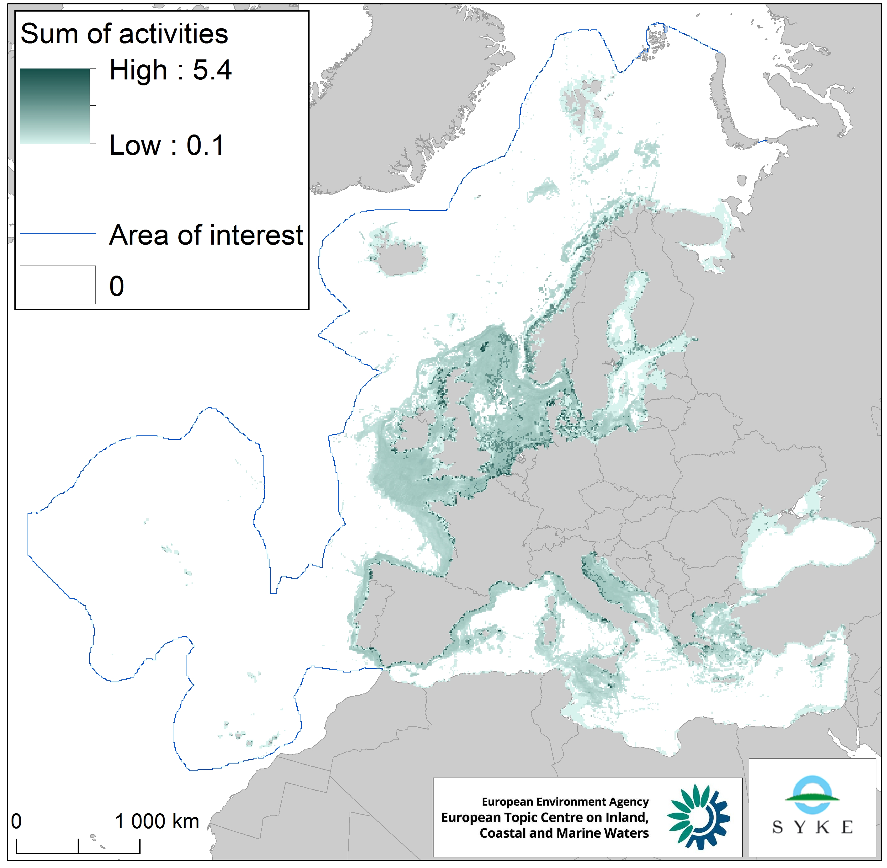
This raster dataset represents physical disturbance to the seabed in the European seas. Several human activities disturb the seabed either directly or indirectly. Alteration of benthic living conditions as a result of increased sedimentation or attenuation of light penetration, abrasion of the seabed and exploitation of benthic biota, temporarily disturb the benthic habitat quality. The dataset is an aggregation of several different human activities that cause physical disturbance to the seabed: aquaculture, demersal fishing, dredging and dumping of dredged material, oil and gas rigs, offshore installations, ports, sand and gravel extraction, shellfish mariculture, shipping in shallow waters and windfarms. The resulting dataset is a raster (10km grid cell) derived from EMODnet, MED-IAMER, JRC-STECF, OSPAR, HELCOM and 4C Offshore datasets, and with reference temporal coverage from 2012 to 2017. This dataset has been prepared for the calculation of the combined effect index, produced for the ETC/ICM Report 4/2019 "Multiple pressures and their combined effects in Europe's seas" available on: https://www.eionet.europa.eu/etcs/etc-icm/etc-icm-report-4-2019-multiple-pressures-and-their-combined-effects-in-europes-seas-1.
-
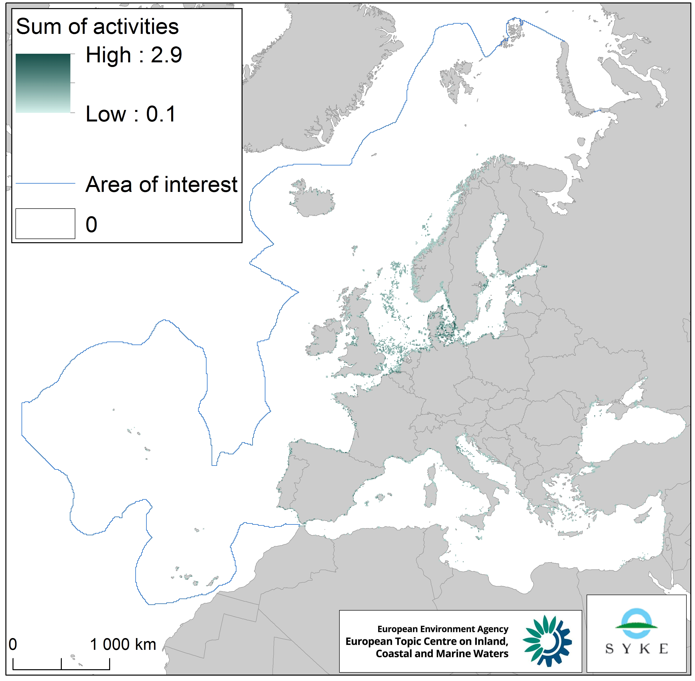
This raster dataset represents the physical loss of the seabed in the European seas. Physical habitat loss is an extreme pressure on the marine ecosystem which was defined to include all impacts on the seabed which take more than 12 years to recover, a time span influencing even long living marine mammals and seabirds. Habitat is lost if its substrate, morphology or topography is permanently altered. The dataset is an aggregation of several different human activities that cause physical loss in the seabed: dredging and dumping of dredged material, oil and gas rigs, offshore installations, ports, sand and gravel extraction and windfarms. The resulting dataset is a raster (10km grid cell) derived from EMODnet, MED-IAMER and 4C Offshore datasets and with temporal reference from 2012 to 2017. Higher values mean more loss causing activity in the area. Due to its resolution, loss causing activity in a cell does not usually mean that all the seabed habitat in the area is lost. This dataset has been prepared for the calculation of the combined effect index, produced for the ETC/ICM Report 4/2019 "Multiple pressures and their combined effects in Europe's seas" available on: https://www.eionet.europa.eu/etcs/etc-icm/etc-icm-report-4-2019-multiple-pressures-and-their-combined-effects-in-europes-seas-1.