 Metadata catalogue
Fault
Type of resources
Available actions
Topics
Keywords
Contact for the resource
Provided by
Years
Formats
Service types
-
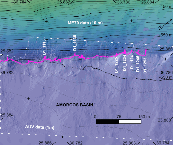
The AMORGOS-23 cruise (https://doi.org/10.17600/18003211) was conducted onboard R/V Europe from April 26th 2023 to May 9th 2023. Using HROV Ariane equipped with 4K cameras, we surveyed the main active faults between Amorgos and Anafi islands in order to identify and quantify recent deformation of the seafloor linked to the 1956 Amorgos earthquake. During dive 244-1, we surveyed the steepest scarp of the Amorgos fault, along its central segment. We provide here seven scaled Digital Outcrop Models (in .obj format) calculated from the HROV videos with MATISSE 3D software. There location (model origin) is also provided in a table, together with information about the portions of the videos used to produce the models. Due to incomplete navigation data, the models are not properly oriented.
-
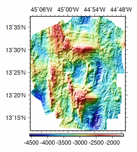
Multibeam bathymetry data, gridded at 40m, acquired around the 13°20'N and 13°30'N oceanic detachments along the Mid-Atlantic Ridge. Bathymetric data was acquired by the PourQUoi Pas? multibeam system (RESON 7150). Data is provided as a grid in GRD format (GMT NETCDF). grdinfo of the file: - ODEMAR_Shipboard_Bathymetry_40m.grd: Title: Bathy_40m.grd - ODEMAR_Shipboard_Bathymetry_40m.grd: Command: File written by MATLAB function grdwrite2.m - ODEMAR_Shipboard_Bathymetry_40m.grd: Remark: Created 22-Nov-2014 16:35:13 - ODEMAR_Shipboard_Bathymetry_40m.grd: Gridline node registration used [Cartesian grid] - ODEMAR_Shipboard_Bathymetry_40m.grd: Grid file format: nf = GMT netCDF format (32-bit float), COARDS, CF-1.5 - ODEMAR_Shipboard_Bathymetry_40m.grd: x_min: -45.14293893 x_max: -44.77177893 x_inc: 0.00036 name: x nx: 1032 - ODEMAR_Shipboard_Bathymetry_40m.grd: y_min: 13.20017553 y_max: 13.62389553 y_inc: 0.00036 name: y ny: 1178 - ODEMAR_Shipboard_Bathymetry_40m.grd: z_min: -4498.29248047 z_max: -1935.33117676 name: z - ODEMAR_Shipboard_Bathymetry_40m.grd: scale_factor: 1 add_offset: 0 - ODEMAR_Shipboard_Bathymetry_40m.grd: format: classic
-
Submarine fault scarp and traces of earthquake (Roseau Fault, French Antilles): 3D scene and imagery
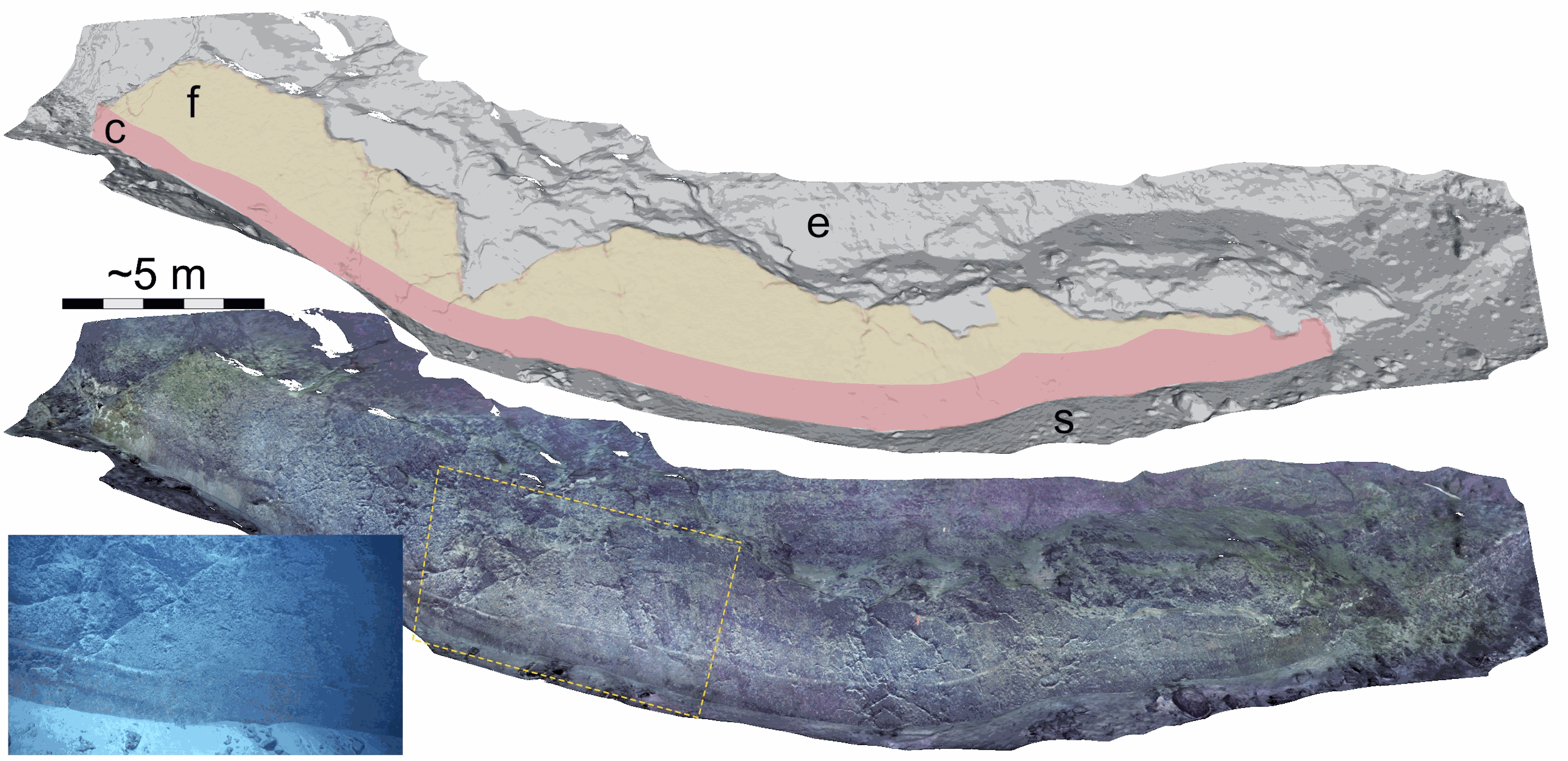
Fault scarp along the Roseau normal fault between Les Saintes and Dominica (French Antilles), at a water depth of 1100 m. This fault scarp is sub-vertical and at its base displays a marker that corresponds to the exposed fault plane during the 2004 Les Saintes Earthquake. The model shows here a coseismic displacement of ~1 m. This scarp was one of several surveyed along the Roseau Fault rupture during the Subsaintes cruise (https://doi.org/10.17600/17001000), with ROV Victor 6000 equipped with an HD Video camera. Two datasets are provided. First, the survey imagery, with a video (mp4 format) and an associated navigation file in txt format. Second, a 3D textured model of the site (obj format), together with the a kml file for georeferencing, and a geotiff orthomosaic. This dataset is one of several sets released with a paper by Arnaubec et al. (submitted March 2021, Computer and Geosciences) presenting the Matisse image processing software, and the 3DMetrics Visualization and analysis software (ref Github to come).
-
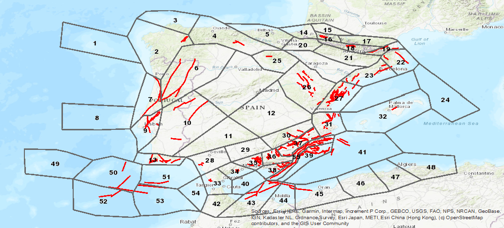
Database visualization service of seismogenic zones of the Iberian Peninsula and territories of influence for the calculation of seismic hazard in Spain (ZESIS)