 Metadata catalogue
EMODnetHRSM2
Type of resources
Topics
INSPIRE themes
Keywords
Contact for the resource
Provided by
Years
Formats
Representation types
Scale
Resolution
-
Data has been derived from charted numbers
-

Bathymetry data was acquired during R/V MARIA S. MERIAN cruise MSM44 in the northeastern Baffin Bay between 30.06.2015 and 30.07.2015. The cruise carried out multidisciplinary research in order to investigate the deglaciation history of the Greenland Ice Sheet (GIS). To research the involved ocean, cryosphere and climate processes and feedbacks and to address the complex spatial and temporal distribution patterns of the marine GIS terminations in the northeast Baffin Bay, RV MARIA S. MERIAN visited sites in the Davis Strait, the Uumannaq Trough, and the Melville Bay during expedition MSM44. The objectives were to systematically search for and map glacigenic seafloor features providing information on the maximum extend and retreat histories of ice sheets since the last glacial maximum and during the Holocene. Extensive mapping was conducted due to the fact, that several huge parts of Greenland’s coast are only insufficiently mapped or completely uncharted and thus are barely reliable in concern of navigation and interpretation towards glacigenic features of the last ice ages. CI Citation: Paul Wintersteller (seafloor-imaging@marum.de) as responsible party for bathymetry raw data ingest and approval.
-
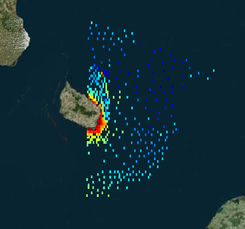
The bathymetric dataset of a single beam sounding. Surveys were conducted in 25 expeditions of the Atlantic branch of Shirshov Institute of Oceanology RAS in the Russian EEZ area of the southeastern part of the Baltic Sea in the period from 2004 to 2018. Acoustic data were acquired by echo sounders Simrad EA-400SP and Furuno FS-700. The raw sounding data were filtered and corrected by sound velocity values. The dataset is presented as spreadsheets (*.xslx) and GIS point-class shapes (*.shp). The digital elevation model (DEM) of 1: 500 000 scale has been constructed for the entire Russian EEZ on base of the original array of sounding profiles and an open sources bathymetry.
-
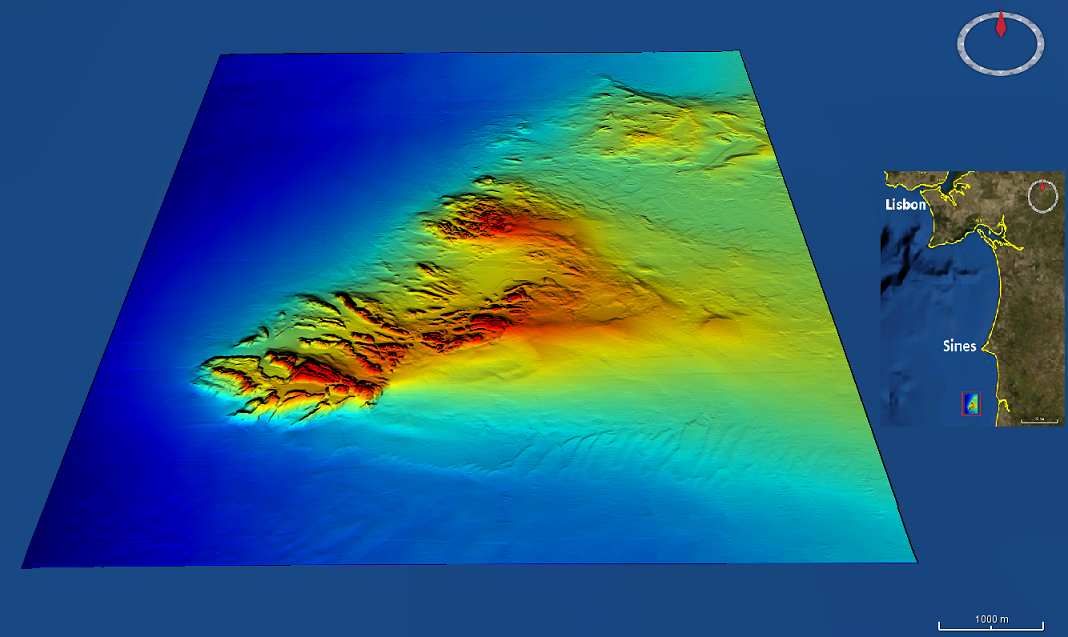
High resolution (1/256 minute ~ 7m) bathymetry dataset from the Mineplat 3 cruise onboard IPMA RV Noruega. Portugal southern continental shelf, off Alentejo coast, 8 to 20 June, 2018. Depths between 80 and 160m. High resolution multichannel seismics and magnetic data acquisition performed during the daytime and multibeam mapping 24h/24h, with a Reson T50-P multibeam echosounder. Depths are referenced to the Portuguese Chart Datum (2m below MSL), horizontal coordinates in the WGS84 reference frame. Position and attitude data (GNSS+Inertial via Applanix OceanMaster POSMV) was pos-processed with POSPAC.
-

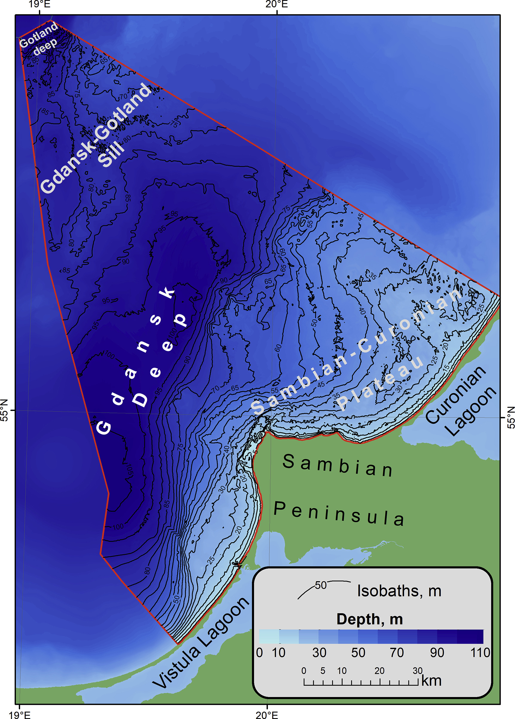
Data extracted from the Hydrographic Office of the Polish Navy (HO) database. Cells in a 200m grid has been populated.