 Metadata catalogue
Digital Elevation Model
Type of resources
Available actions
Topics
INSPIRE themes
Keywords
Contact for the resource
Provided by
Formats
Representation types
Update frequencies
status
-

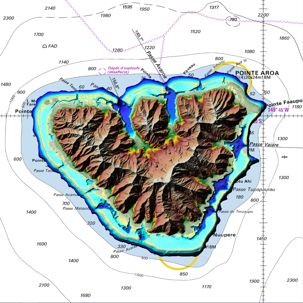
The coastal topo-bathymetric DEM of Tahiti with a resolution of 0.0002° (~ 20 m) was produced by the Shom for Météo-France (Inter-regional Direction in French Polynesia). This DEM covers the Tahiti lagoons down to the 100 m isobath, in order to meet the need for modeling marine submersions in French Polynesia. It complements the bathymetric DEM of Tahiti and Moorea, with a resolution of 0.001° (~ 100 m). This product is available at different vertical references, either the lowest astronomical tide (LAT) or the mean sea level (MSL).
-
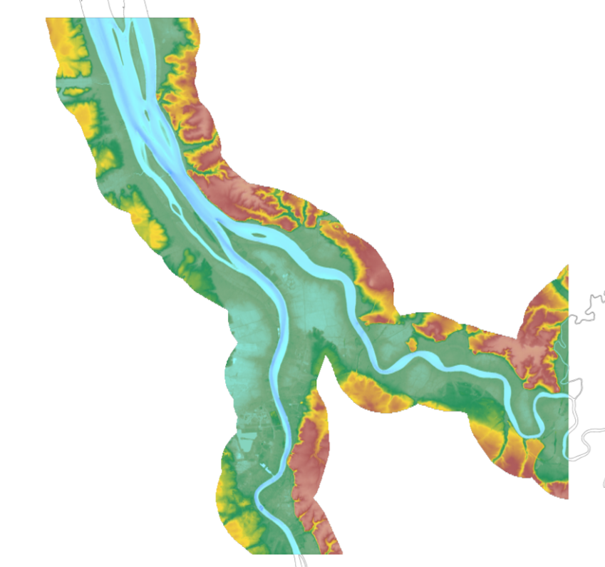
The update of the coastal topo-bathymetric DEM of the Gironde estuary - upstream with a resolution of 0.0002° (~ 20 m) was carried out in the third phase of the HOMONIM project. This DEM covers the upstream part of the Gironde estuary, from Pauillac to Bordeaux on the Garonne and to Libourne on the Dordogne. It is complementary to the DEM covering the downstream estuary (between Pauillac and the mouth of the Gironde). The DEM is intended to be implemented in hydrodynamic models in order to produce forecasts as accurate as possible of water heights and sea states at the coast to improve the relevance of the Wave-Submergence Vigilance. This product is available with either the Lowest Astronomic Tide (LAT) or the Mean Sea Level (MSL) as a vertical reference.
-

The update of the coastal topo-bathymetric DEM of the Gironde estuary - downstream with a resolution of 0.0002° (~ 20 m) was carried out in the third phase of the HOMONIM project. This DEM covers the downstream part of the Gironde estuary, from Pauillac to its mouth. It is complementary to the DEM covering the upstream estuary. The DEM is intended to be implemented in hydrodynamic models in order to produce forecasts as accurate as possible of water heights and sea states at the coast to improve the relevance of the Wave-Submergence Vigilance. This product is available with either the Lowest Astronomic Tide (LAT) or the Mean Sea Level (MSL) as a vertical reference.
-

The bathymetric DEM of Tahiti and Moorea with a resolution of 0.001° (~ 100 m) was produced by the Shom for Météo-France (Inter-regional Direction in French Polynesia). This DEM covers a 10 km radius around the islands of Tahiti and Moorea in order to meet the need for marine submersions modelling in French Polynesia. This product is available at different vertical references, either the lowest astronomical tide (LAT) or the mean sea level (MSL).
-

The coastal topobathymetric DEM of Ré Island's surroundings, with a resolution of 0.00005° (~5 meters), was created by Shom as part of the HOMONIM-3 project. It covers the coast of the municipalities of Ars-en-Ré and Saint-Clément-des-Baleines, extending offshore to a depth of about 20 meters, to the west of the Phare des Baleines lighthouse. This DEM is designed for use in hydrodynamic models to enhance the modeling of coastal processes, particularly forecasting submersion risk. The product complements the coastal topobathymetric DEM of the Pertuis-Charentais, with a resolution of 0.0002° (~20 meters), and the bathymetric DEM of the Atlantic coast, with a resolution of 0.001° (~100 meters). It is available in the vertical reference of the Lowest Astronomical Tide (LAT) or the Mean Sea Level (MSL).
-
The coastal topo-bathymetric DEM of Moorea with a resolution of 0.0002° (~ 20 m) was produced by the Shom for Météo-France (Inter-regional Direction in French Polynesia). This DEM covers the Moorea lagoons down to the 100 m isobath, in order to meet the need for modeling marine submersions in French Polynesia. It complements the bathymetric DEM of Tahiti and Moorea, with a resolution of 0.001° (~ 100 m). This product is available at different vertical references, either the lowest astronomical tide (LAT) or the mean sea level (MSL).
-

Digital Elevation Model (DEM) and orthophotography of La Palue and Lostmarc’h beaches in Crozon peninsula (France) from the photogrammetric processing of drone images (DJI Phantom 4 RTK) with a flying height of 100 m.
-
In order to facilitate capturing three-dimensional beach change, full surveys of the subaerial beach have been conducted starting in 2004 using RTK-GNSS (survey method GPS), Unmanned Aerial Vehicle (UAV) imagery processed using Structure-from-Motion (SfM) photogrammetry (survey method PHO) and terrestrial laser-scanning (survey method TLS). For each survey, we prepared a Digital Elevation Model (DEM) at a fixed sampling distance of 0.5 m.