 Metadata catalogue
Cross-discipline
Type of resources
Available actions
Topics
Keywords
Contact for the resource
Provided by
Years
Formats
-
Black and white seafloor photomosaic of the Lucky Strike hydrothermal field and the ridge axis to the South, acquired with VICTOR6000 during the Bathyluck 2009. Individual still images were matched, corrected for uneven illumination, renavigated and blended for a seamless photomosaic. This data release includes partial geotiffs covering the whole surveyed area. To be cited: Gini et al. (submitted); Barreyre et al. (2012); Escartin et al. (2013); Escartín et al. (2015).
-
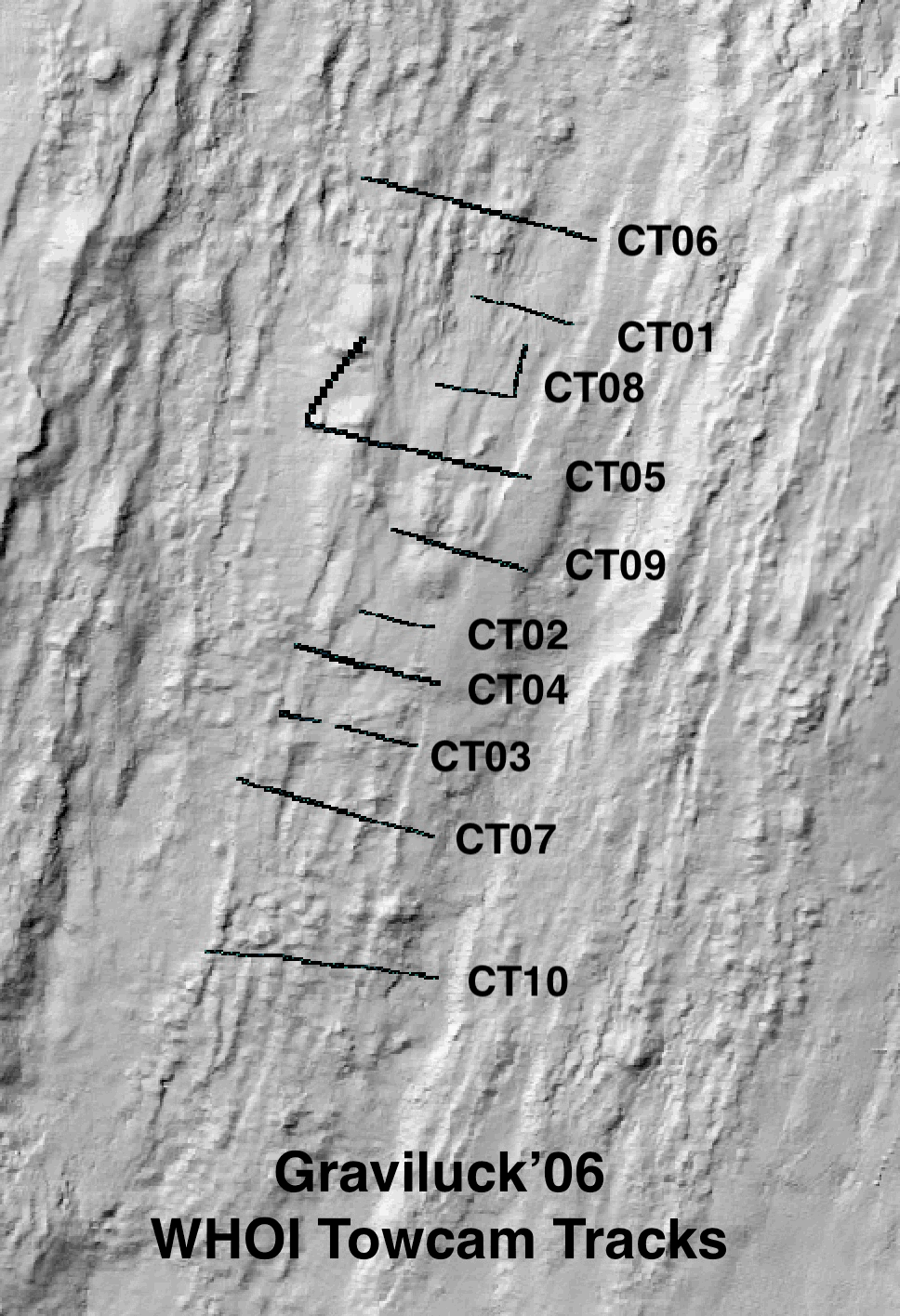
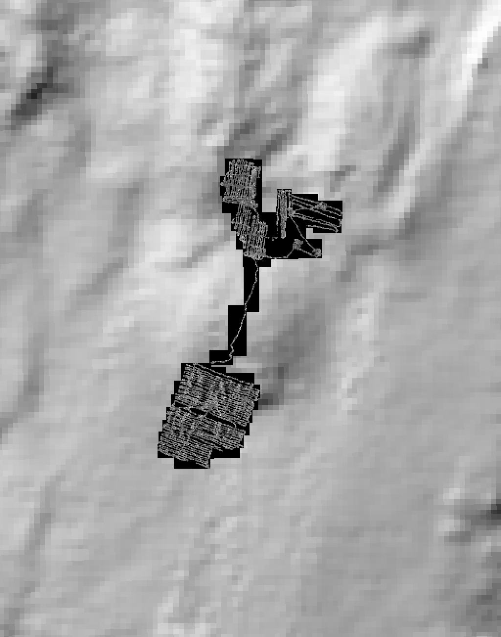
Colour seafloor photomosaics along towed camera tracks crossing the axis of the Lucky Strike ridge segment (Mid Altantic Ridge). Images were acquired with the WHOI TowCam system (https://www.whoi.edu/what-we-do/explore/underwater-vehicles/towed-vehicles/towcam/), during the Graviluck 2016 cruise. Images are process for colour and illumination correction. Images are placed and photomosaiced based on USBL navigation of the TowCam, altitude, and orientation. The datasets include geotiffs for each of the tracks. To be cited: cited: Gini et al. (submitted); Escartin et al. (2008; 2014).
-
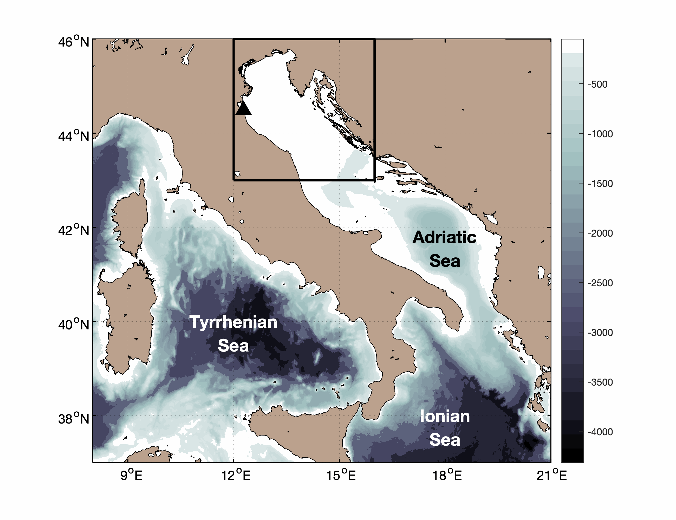
Pialassa Baiona is a temperate coastal lagoon connected with the Northwestern Adriatic Sea (44° 280 N and 44°310 E). Sediment cores and surface sediments were collected in two habitats within Pialassa Baiona: a) a salt marsh habitat characterized by the presence of saltmarsh vegetation, and b) a human impacted habitat close to anthropogenic source inputs. Cores were sampled by inserting one cylindrical Plexiglas hand corer (5-cm diameter, 50 cm long) into the sediment to a depth of 20-25 cm, and surface sediment samples (0–5 cm) were collected with a stainless-steel grab sampler. The cores were extruded in the field, sectioned into 1‐2 cm intervals, and analyzed for total organic carbon (OC), total nitrogen (TN), carbon isotope ratio (δ13C) and dry bulk density (upper 20 – 25 cm) and analyzed for organic carbon (OC), total nitrogen (TN), carbon isotope ratio (δ13C) and dry bulk density. Organic carbon (OC), total nitrogen (TN), and carbon isotopes (δ13C = [(13C/12C)sample/(13C/12C)standard − 1] × 1,000) were measured in sediment cores and surface sediments using a using a FINNIGAN Delta Plus XP mass spectrometer directly coupled to Thermo Fisher FLASH 2000 CHNS Elemental Analyzer. OC and TN content was expressed as the weight percentage of dried sediment, and carbon isotope results were reported in the standard delta notation with respect to the Vienna Pee Dee Belemnite. A ‘three-end member’ mixing model was used to estimate the relative contribution of the different organic matter (OM) sources: marine phytoplankton (FM), riverine-estuarine phytoplankton (FRE), and C3 saltmarsh plant material (FSM): δ13Csample = δ13CM x FM + δ13CFE x FFE + δ13CSM x FSM C/Nsample = C/NM x FM + C/NFE x FFE + C/NSM x FSM 1 = FM + FRE + FSM where FM, FRE and FSM are the relative contributions of marine phytoplankton, riverine-estuarine phytoplankton, and saltmarsh plant material, respectively. δ13CM (-18.97‰) and C/NM (4.95), and δ13CRE (-30.70‰,) and C/NRE (6.63) represent the end member POC signature recorded during distinct marine and estuarine phytoplankton blooms in the coastal lagoon (Guerra et al., 2013).The C3 saltmarsh plant end-member was selected on the basis of typical δ13CSM (-20.2‰) and C/NSM (15.35) values for Juncus spp. (Gebrehiwet et al., 2008; Hughes and Sherr, 1983; J. I. Kelleway et al., 2017; Kemp et al., 2012, 2010; Lamb et al., 2006). References Gebrehiwet, T., Koretsky, C.M., Krishnamurthy, R. V., 2008. Influence of Spartina and Juncus on saltmarsh sediments. III. Organic geochemistry. Chem. Geol. 255, 114–119. https://doi.org/10.1016/j.chemgeo.2008.06.015 Guerra, R., Pistocchi, R., Vanucci, S., 2013. Dynamics and sources of organic carbon in suspended particulate matter and sediments in Pialassa Baiona lagoon (NW Adriatic Sea, Italy). Estuar. Coast. Shelf Sci. 135, 24–32. https://doi.org/10.1016/j.ecss.2013.06.022 Kelleway, J.I., Saintilan, N., Macreadie, P.I., Baldock, J.A., Ralph, P.J., 2017. Sediment and carbon deposition vary among vegetation assemblages in a coastal salt marsh. Biogeosciences 14, 3763–3779. https://doi.org/10.5194/bg-14-3763-2017 Kemp, A.C., Vane, C.H., Horton, B.P., Culver, S.J., 2010. Stable carbon isotopes as potential sea-level indicators in salt marshes, North Carolina, USA. Holocene 20, 623–636. https://doi.org/10.1177/0959683609354302 Kemp, A.C., Vane, C.H., Horton, B.P., Engelhart, S.E., Nikitina, D., 2012. Application of stable carbon isotopes for reconstructing salt-marsh floral zones and relative sea level, New Jersey, USA. J. Quat. Sci. 27, 404–414. https://doi.org/10.1002/jqs.1561
-
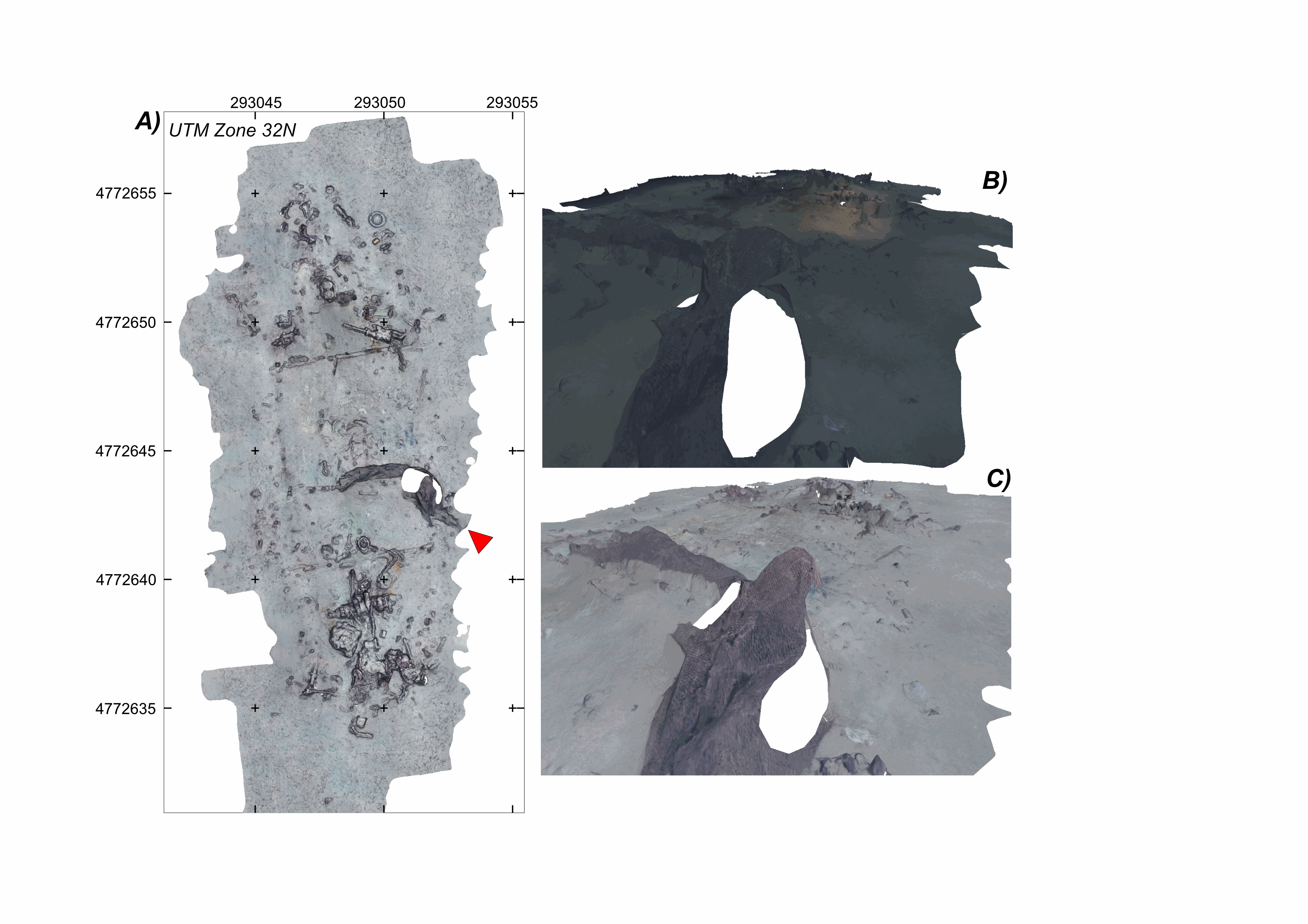
Litter site at the seafloor, off the southern French Mediterranean coast (43.078°N;6.458°E), at a water depth of ~600 m This litter field was surveyed using the HROV Arianne in 2017, deployed from N/O L’Europe, and equipped with a vertical electronic still camera. Two datasets are provided. First, the survey imagery, under a folder named carthorov_dump, that consists of 303 images (jpeg format) and an associated navigation file in dim2 format. Second, 2 folders with 3D textured models of the site (obj format), each with a kml file for georeferencing, and an geotiff orthomosaic. A first model is the result of processing imagery without data correction (folder WithoutAnyCorrection). A second model is processed with image colour correction (folder WithColorAndIlluminationCorrection). This dataset is one of several released with a paper by Arnaubec et al. (submitted March 2021, Computer and Geosciences) presenting the Matisse image processing software and the 3DMetrics Visualization and analysis software and released as open source (ref Github to come). Ref: Arnaubec, A., J. Escartín, J. Opderbecke, M. Matabos, N. Gracias, submitted, Underwater 3D terrain reconstruction from video or still imagery: Processing and exploitation software (MATISSE \& 3DMETRICS), in prep., Computers and Geosciences.
-
Submarine fault scarp and traces of earthquake (Roseau Fault, French Antilles): 3D scene and imagery
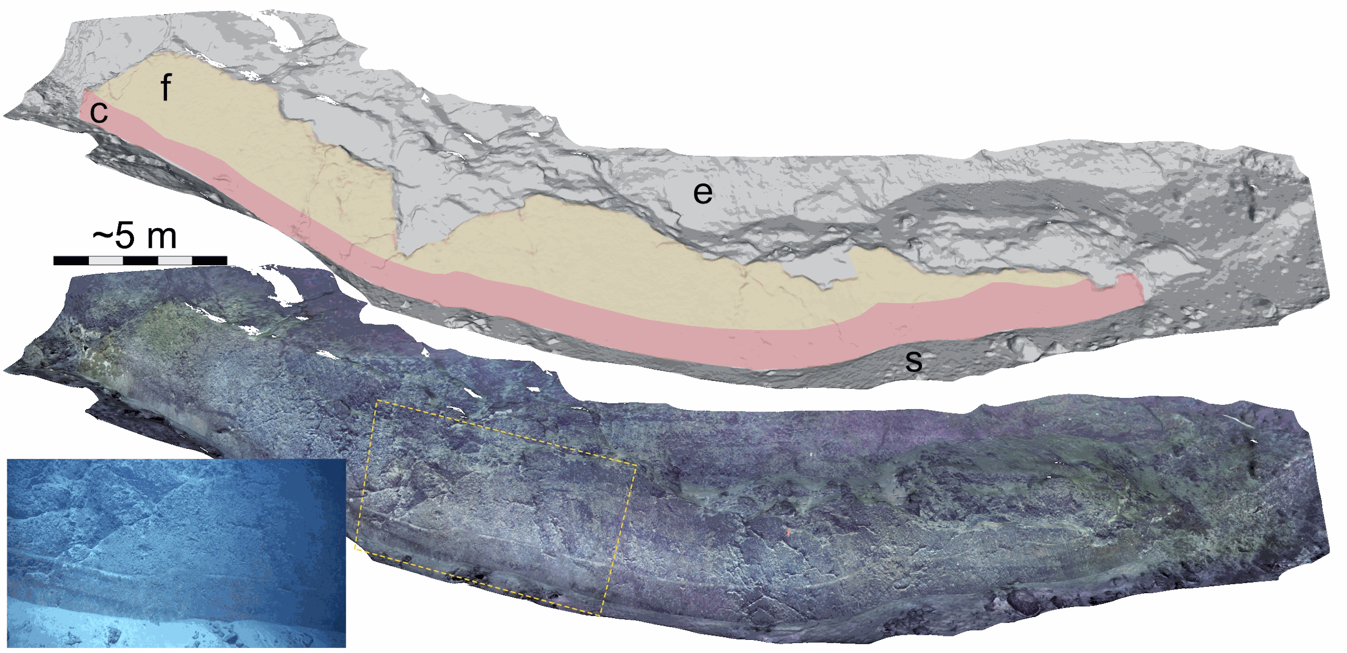
Fault scarp along the Roseau normal fault between Les Saintes and Dominica (French Antilles), at a water depth of 1100 m. This fault scarp is sub-vertical and at its base displays a marker that corresponds to the exposed fault plane during the 2004 Les Saintes Earthquake. The model shows here a coseismic displacement of ~1 m. This scarp was one of several surveyed along the Roseau Fault rupture during the Subsaintes cruise (https://doi.org/10.17600/17001000), with ROV Victor 6000 equipped with an HD Video camera. Two datasets are provided. First, the survey imagery, with a video (mp4 format) and an associated navigation file in txt format. Second, a 3D textured model of the site (obj format), together with the a kml file for georeferencing, and a geotiff orthomosaic. This dataset is one of several sets released with a paper by Arnaubec et al. (submitted March 2021, Computer and Geosciences) presenting the Matisse image processing software, and the 3DMetrics Visualization and analysis software (ref Github to come).
-
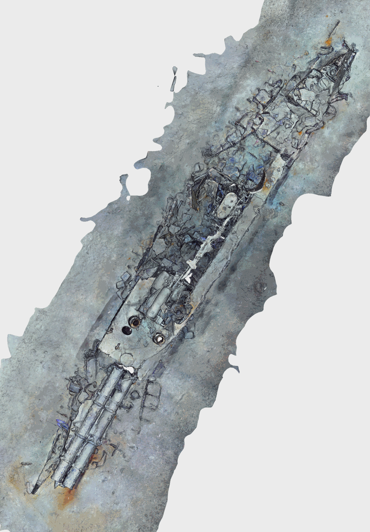
Abstract Torpedo boat wreck off-the southern French Mediterranean coast (43.124°N;6.523°E), at a water depth of ~476 m. This battle ship sank in 1903 (https://www.postenavalemilitaire.com/t11913-torpilleur-059-1881-1903) and the wreck is is ~20 m long and 3 m wide, raising ~2 m above the surrounding seafloor. This shipwreck was surveyed using the HROV Arianne in 2016, deployed from N/O L’Europe, and equipped with a vertical electronic still camera. Two datasets are provided. First, the survey imagery, that consists of 442 images (jpeg format) and an associated navigation file in dim2 format (torpdo_boat_imagery). Second, a 3D textured model of the site (obj format), together with the a kml file for georeferencing, and a geotiff orthomosaic (torpedo_boat_model). This dataset is one of several sets released with a paper by Arnaubec et al. (submitted to Computer and Geosciences) presenting the Matisse image processing software, and the 3DMetrics Visualization and analysis software (ref Github to come). Arnaubec, A., J. Escartín, J. Opderbecke, M. Matabos, N. Gracias, submitted, Underwater 3D terrain reconstruction from video or still imagery: Processing and exploitation software (MATISSE \& 3DMETRICS), Computers and Geosciences