 Metadata catalogue
Chemical oceanography
Type of resources
Available actions
Topics
Keywords
Contact for the resource
Provided by
Years
Formats
-
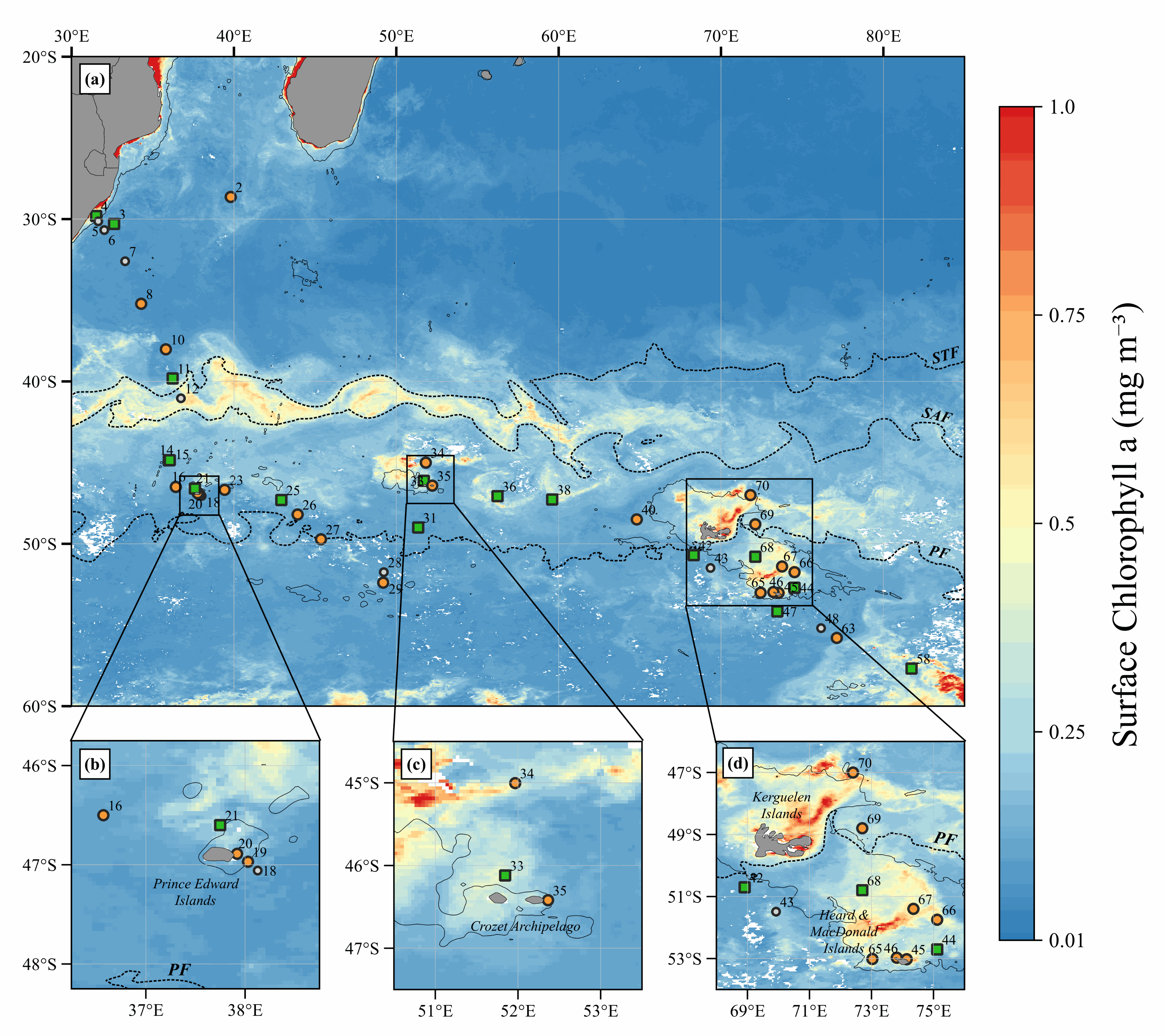
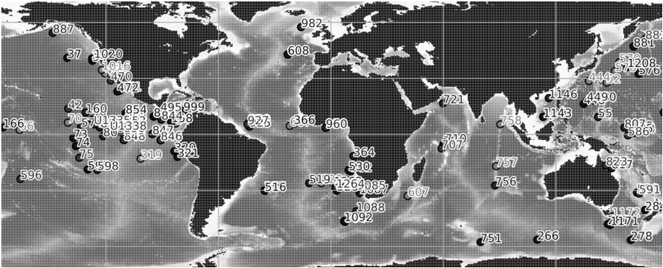
Data of parameters presented as figures in the manuscript: Biogenic silica (BSi: µmol.L-1), Lithogenic silicon (LSi: µmol.L-1), Total Chlorophyll a (TChla: mg.m-3) and Fucoxanthin (Fuco: mg.m-3). Note that: - Total fraction for BSi and LSi is available from Niskin bottles (> 0.8 µm) and in situ pumps (> 0.45 µm); - Size-fractions for BSi and LSi is available from in situ pumps only (5-53 µm; > 53 µm); - Total fraction for TChla and Fuco is available from Niskin bottles (> 0.7 µm). - Integrated data (0-200 m) is available from Niskin Bottles. Acronym explanations: - Sampling type: ISP = In Situ Pump; ISP-SF = In Situ Pump with Size-Fraction; NSK = Niskin. - Method used for BSi and LSi computation: NOC = No Correction applied; RAG = Correction using the method used from the protocol established by Ragueneau et al. (2005); ACR = Average Crustal Ratio method used when one of the criterion from the protocol established by Ragueneau et al. (2005) is not respected. - bdl = Below Detection Limit For further explanations in the method, should you please refer to the Material and Methods section in the manuscript (revised version submitted in Marine Chemistry).
-
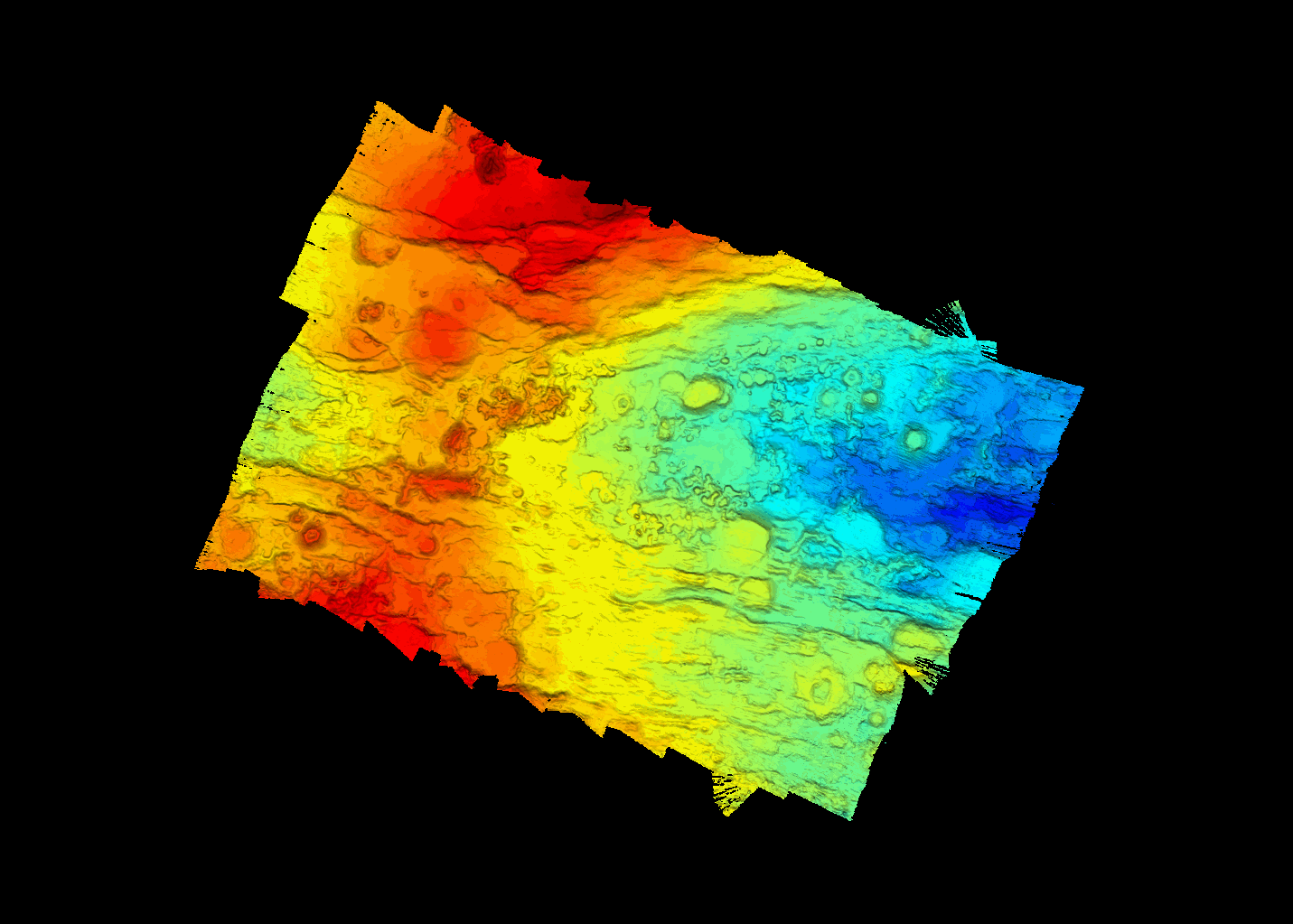
A MBES acoustic coverage of the PE-1 segment of the SWIR (South West Indian Ridge), more specifically in the vicinity of the dredge 5 location of the SWIFT cruise (2001), was carried out during the SWINGS cruise (https://doi.org/10.17600/18001925) with the French research vessel Marion Dufresne in 2021. SWINGS data were acquired with the hull-mounted multibeam echosounder Kongsberg EM122 12 kHz using an optimised configuration for bathymetry data collection: vessel speed of 5 knots, dual swath, CW signal and an angular opening of 120°. Acoustic data were processed with GLOBE software (https://doi.org/10.17882/70460) to provide a high-resolution bathymetry map (grid resolution of 15 m).
-
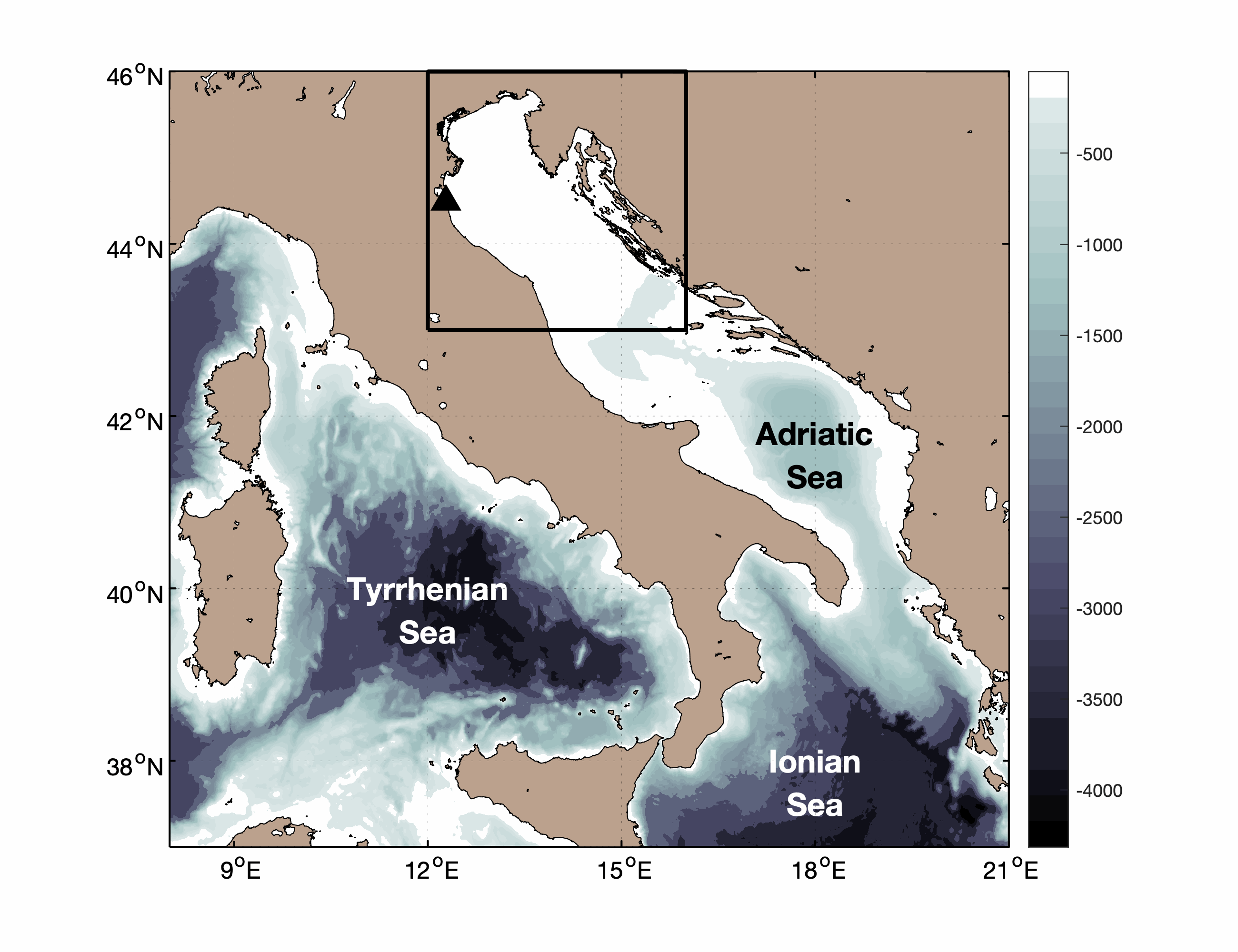
Pialassa Baiona is a temperate coastal lagoon connected with the Northwestern Adriatic Sea (44° 280 N and 44°310 E). Sediment cores and surface sediments were collected in two habitats within Pialassa Baiona: a) a salt marsh habitat characterized by the presence of saltmarsh vegetation, and b) a human impacted habitat close to anthropogenic source inputs. Cores were sampled by inserting one cylindrical Plexiglas hand corer (5-cm diameter, 50 cm long) into the sediment to a depth of 20-25 cm, and surface sediment samples (0–5 cm) were collected with a stainless-steel grab sampler. The cores were extruded in the field, sectioned into 1‐2 cm intervals, and analyzed for total organic carbon (OC), total nitrogen (TN), carbon isotope ratio (δ13C) and dry bulk density (upper 20 – 25 cm) and analyzed for organic carbon (OC), total nitrogen (TN), carbon isotope ratio (δ13C) and dry bulk density. Organic carbon (OC), total nitrogen (TN), and carbon isotopes (δ13C = [(13C/12C)sample/(13C/12C)standard − 1] × 1,000) were measured in sediment cores and surface sediments using a using a FINNIGAN Delta Plus XP mass spectrometer directly coupled to Thermo Fisher FLASH 2000 CHNS Elemental Analyzer. OC and TN content was expressed as the weight percentage of dried sediment, and carbon isotope results were reported in the standard delta notation with respect to the Vienna Pee Dee Belemnite. A ‘three-end member’ mixing model was used to estimate the relative contribution of the different organic matter (OM) sources: marine phytoplankton (FM), riverine-estuarine phytoplankton (FRE), and C3 saltmarsh plant material (FSM): δ13Csample = δ13CM x FM + δ13CFE x FFE + δ13CSM x FSM C/Nsample = C/NM x FM + C/NFE x FFE + C/NSM x FSM 1 = FM + FRE + FSM where FM, FRE and FSM are the relative contributions of marine phytoplankton, riverine-estuarine phytoplankton, and saltmarsh plant material, respectively. δ13CM (-18.97‰) and C/NM (4.95), and δ13CRE (-30.70‰,) and C/NRE (6.63) represent the end member POC signature recorded during distinct marine and estuarine phytoplankton blooms in the coastal lagoon (Guerra et al., 2013).The C3 saltmarsh plant end-member was selected on the basis of typical δ13CSM (-20.2‰) and C/NSM (15.35) values for Juncus spp. (Gebrehiwet et al., 2008; Hughes and Sherr, 1983; J. I. Kelleway et al., 2017; Kemp et al., 2012, 2010; Lamb et al., 2006). References Gebrehiwet, T., Koretsky, C.M., Krishnamurthy, R. V., 2008. Influence of Spartina and Juncus on saltmarsh sediments. III. Organic geochemistry. Chem. Geol. 255, 114–119. https://doi.org/10.1016/j.chemgeo.2008.06.015 Guerra, R., Pistocchi, R., Vanucci, S., 2013. Dynamics and sources of organic carbon in suspended particulate matter and sediments in Pialassa Baiona lagoon (NW Adriatic Sea, Italy). Estuar. Coast. Shelf Sci. 135, 24–32. https://doi.org/10.1016/j.ecss.2013.06.022 Kelleway, J.I., Saintilan, N., Macreadie, P.I., Baldock, J.A., Ralph, P.J., 2017. Sediment and carbon deposition vary among vegetation assemblages in a coastal salt marsh. Biogeosciences 14, 3763–3779. https://doi.org/10.5194/bg-14-3763-2017 Kemp, A.C., Vane, C.H., Horton, B.P., Culver, S.J., 2010. Stable carbon isotopes as potential sea-level indicators in salt marshes, North Carolina, USA. Holocene 20, 623–636. https://doi.org/10.1177/0959683609354302 Kemp, A.C., Vane, C.H., Horton, B.P., Engelhart, S.E., Nikitina, D., 2012. Application of stable carbon isotopes for reconstructing salt-marsh floral zones and relative sea level, New Jersey, USA. J. Quat. Sci. 27, 404–414. https://doi.org/10.1002/jqs.1561
-
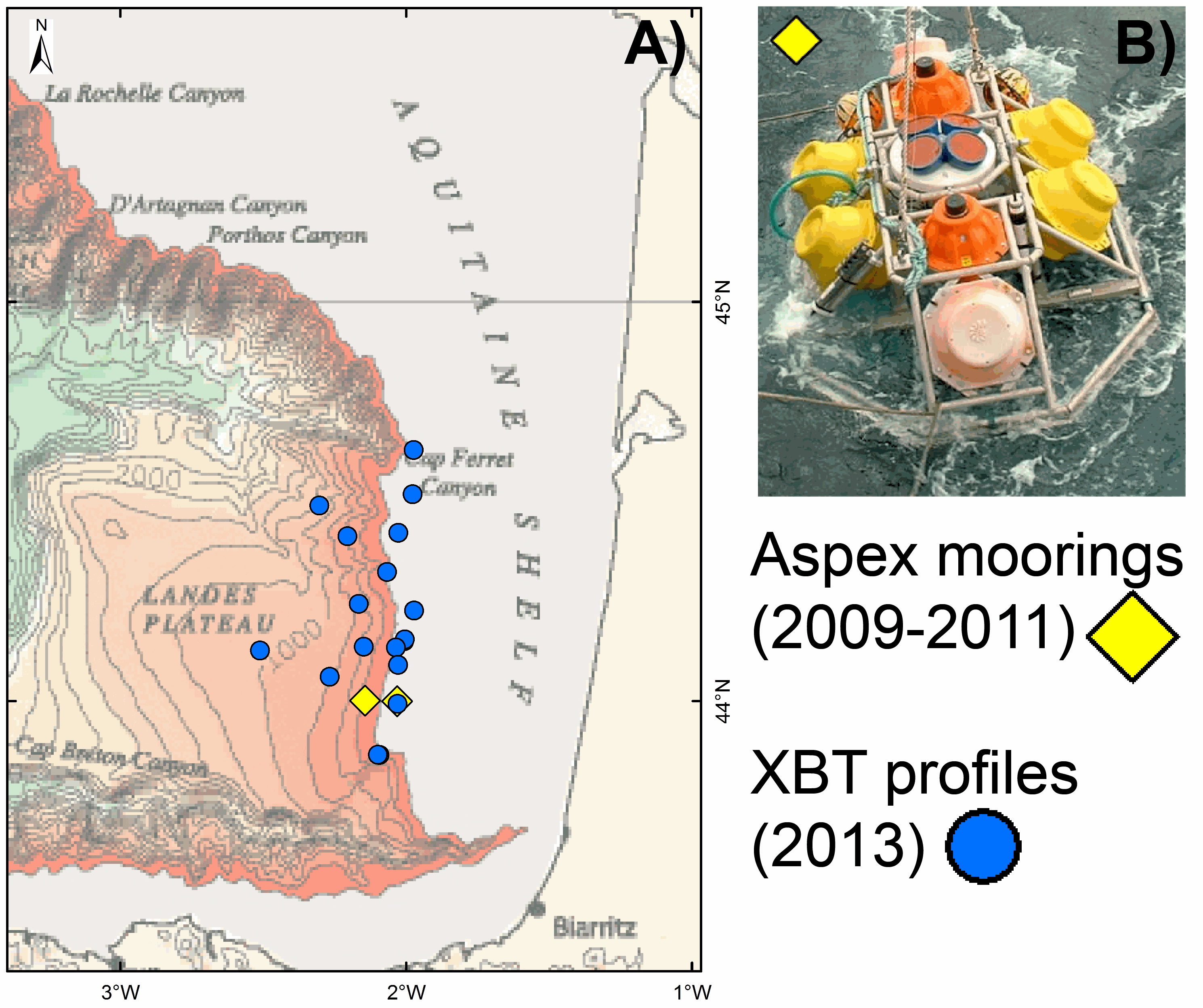
As part of the EPIGRAM project, two moorings, Aspex 9 and 10, equipped with temperature, conductivity and pressure sensors (Seabird microcat 37SM), were deployed offshore Aquitaine for a period of 2 years (2009-2011). The probes were calibrated in metrology and provide salinity values derived from calculations based on Fofonoff and Millard (1983) [Fofonoff, P. and Millard, R.C. Jr UNESCO 1983. Algorithms for computation of fundamental properties of seawater. UNESCO Tech. Pap. in Mar. Sci., No. 44, 53 pp. Eqn.(31) p.39. http://unesdoc.UNESCO.org/images/0005/000598/059832eb.pdf]. Several oceanographic missions ASPEX1, 2, 3 and 4, were dedicated to deploying and recovering these instruments. The frame of the mooring (Figure B) is laid on the seafloor with sensors at 0.5 m above it. Aspex 9 and 10 moorings are located at the continental shelf (at 148 m water depth) and continental slope (at 472 m water depth), respectively (Fig. A). Aspex 9 mooring recorded data from 18.07.2009 at 23:40:00 to 01.07.2010 at 09:18:00 (with a measurement every 120 seconds) and from 04.09.2010 at 23:30:00 to 10.08.2011 at 06:57:00 (with a measurement every 180 seconds). Aspex 10 mooring recorded data from the 18.07.2009 at 21:40:00 to 22.07.2010 at 23:18:01 and from 05.09.2010 at 01:20:00 to 10.08.2011 at 04:58:00 (with a measurement every 120 seconds). This ASPEX dataset can be downloaded from here: a zip file containing one .txt file with indications of recording time, location and water depth of the two moorings and four data files (one .txt file per mooring and per recorded period) with for each measurement the year (YYYY), month (MM), day (DD), hour (hh), minute (mm) second (ss) and pressure (P), temperature (T), conductivity (C) and salinity (S) values. As part of the PAMELA project, 18 XBT (eXpendable BathyThermograph) probes (Sippican) were launched in 2013 (July to September) offshore Aquitaine Basin. Seawater temperature profiles were thus acquired through the water column from different locations at the shelf area (at 140 m water depth), the continental slope and the basin (at 1213 m water depth) (Fig. A). Some of these XBT profiles are accessible via the Coriolis platform (http://www.coriolis.eu.org/). The complete GAZCOGNE1-2 dataset can be downloaded from here: a zip file containing one .txt file with indications of time, location and water depth for the XBTs and 18 data files (one .txt file per XBT profile). All times are in UTC.
-
Compilation of published ocean drilling (DSDP, ODP and IODP) records of sedimentation rates, CaCO3, opal and terrigenous accumulation rates that cover the late Miocene and early Pliocene interval. We compiled oceanographic data from DSDP, ODP and IODP expeditions that cover the late Miocene and early Pliocene. Data mining was performed by automatically collecting the Pangaea datasets that correspond to the selected time interval and that have at least one of the following variables: sedimentation rate, dry bulk density, mass accumulation rate (MAR), CaCO3 accumulation rate, bSiO2 accumulation rate (biogenic SiO2) , %CaCO3, %bSiO2. The compilation was then improved by manually adding datasets absent from Pangaea but relevant to our study. The data compilation contains 154 datasets (122 are from Pangaea) from 118 different ocean drilling sites. Age-depth models have been calibrated to the GTS2020 time scale in order to perform a temporal comparison of the datasets. This step was performed using the Neptune Sandbox Berlin database (Renaudie et al. 2020, Palaeontologia Electronica, DOI:10.26879/1032). The Meta_Data_Table file is a metadata table with the following information : site number, dataset label, site label, publication, elevation, site coordinates, site paleocoordinates (10 Ma), available variables, variables used for labeling, the time scale used in the original publication, and the web link to the original dataset. The Time_series file is a file that contains the time series of all the variables in all the data sets in this repository. Each file (.csv) contains a dataset and includes the following information: - Site number - Original link of the dataset - Citation - List of ages - List of values for each variable
-
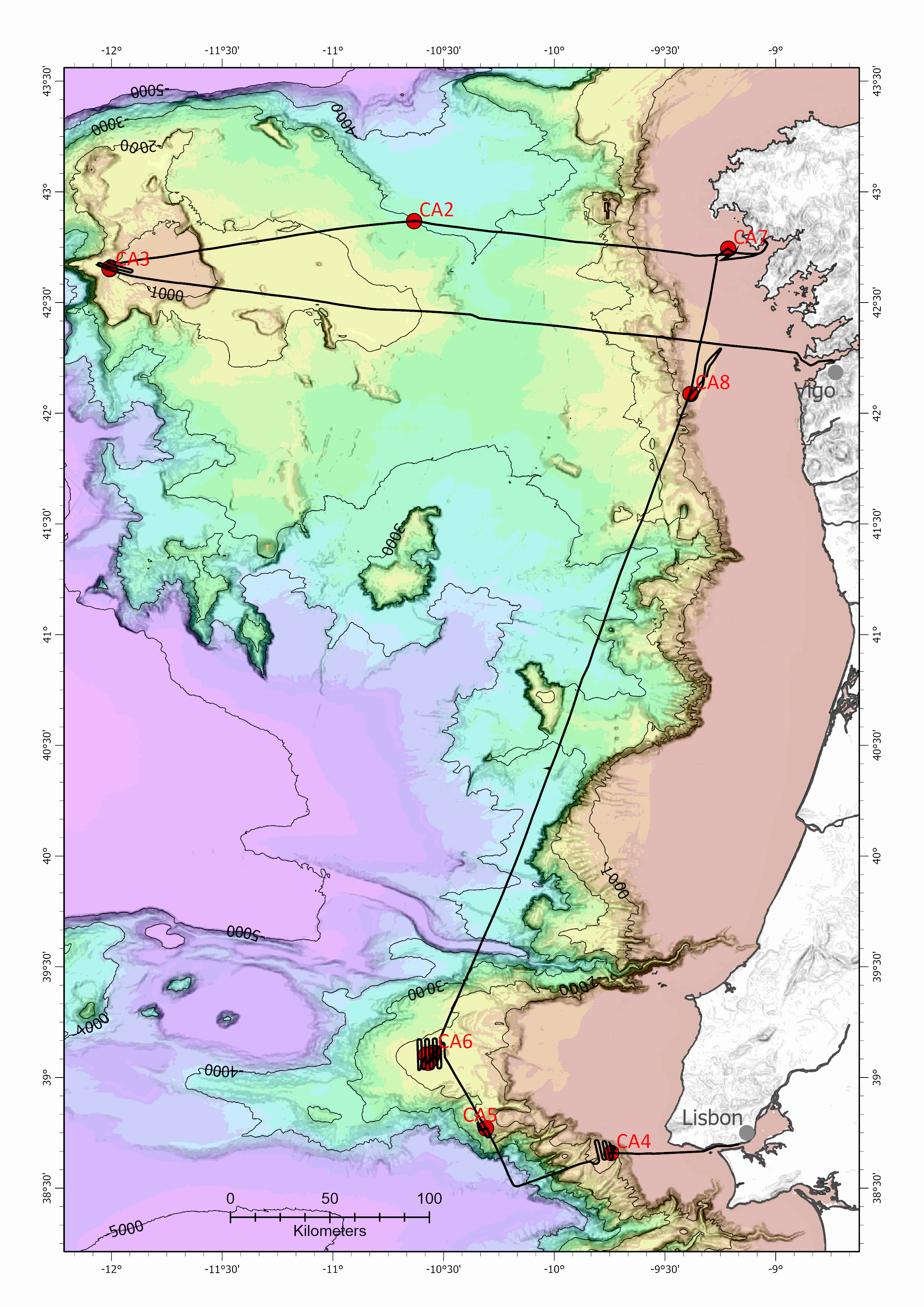
The CARBO-ACID research cruise (EUROFLEETS+ SEA02_10) was carried out on the RV Ramón Margalef between August 2nd and August 11st, with departing from Vigo – Spain and ending in Lisbon – Portugal. The main objective of this cruise was to collect data and samples to study the potential effects of ocean acidification on carbonate marine organisms (coccolithophores, pteropods, planktonic and benthic foraminifera, and corals) along the Iberian margin. With this objective, oceanographic data and water samples, plankton, cold-water corals and sediment samples were collected during an upwelling season, along two transects coinciding with the two persistent upwelling filaments off the Iberia Margin: the Cape Finisterra and the Cape Roca. In this dataset is guiven all the acquired data recollected onboad. During the CARBO-ACID cruise we did a total of 7 stations, 4 stations along the Cape Finisterra transect (from W to E: CA3, CA2, CA7, CA8) and 3 stations at the Cape Roca (from W to E: CA6, CA5, CA4) transect (Fig). At each station we usually started with a multibeam survey, a CTD and Rosette cast. These initial operations allowed to identify the different water masses present in this area, characterize their physical properties and to recover seawater samples at specific depth levels. The seawater samples were onboard subsampled, preserved in cold conditions or with chemicals and/ or filtered for several further analysis in the shore-based laboratories: DNA, chlorophyll, fitoplankton, coccolithophores, pH, alkalinity, stable isotopic composition, trace elements concentration and Suspend Particulate Matter. Subsequently to these operations, at each station, two vertical tows with a plankton multinet (with 5 nets) were done on the top 700 m of the water column to sample the planktonic communities of the different water depths. After this, sediment samples were recovered with a box-corer to study the past oceanographic conditions, between the pre-industrial Era and the Present, with multi-proxies used in paleoceanography and sedimentology. A total of 10 box-cores were recollected and each of them was onboard sub-sampled for eDNA, enzymes and benthic foraminifera. Fifteen shipek grab samples were recollected at the Fontanelas seamount (Estremadura Spur), station CA6, to characterize the sedimentary cover and to evaluate the presence of deep cold-water corals. Preliminary results show that the stations CA7, CA8 and CA4, located close to the coast, as expected, are the most influenced by the coastal upwelling, exhibiting colder surface water, higher values of fluorescence, and more zooplankton content reflecting higher phyto-zooplankton concentrations, as typical of the upwelling waters. At station CA4 temperature was higher and fluorescence showed lower values, indicative of less phytoplankton, and interpreted as indicating a different upwelling source water from that upwelled further north. Based on the CTD data, the Cape Roca transect is more influenced by the subtropical East North Atlantic Central Water (ENACWst), while the Cape Finisterra transect is more under the influence of the subpolar branch (ENACWsp). Seafloor sediment samples showed significant differences between the stations. Along the northern transect (Cape Finisterra) the seafloor sediments show an increase in grain size from the offshore to the coast. The offshore stations CA3 and CA2 revealed finer grained sediments, CA8 were composed of coarser sand and the station CA7, the shallowest station 77 m, presented the sediment composed mainly of shell fragments and coarse grain sand. Along the southern transect (Cape Roca), the offshore station CA6 (Fontanelas seamount) has coarser sandy sediments with rock clasts and cold-water coral fragments, and the stations CA5 and CA4 with fine sand to muddy sediments. The detailed CA6 bathymetry allowed to verify the existence of small plateaus on the slope of the Fontanelas seamount, where the fossil cold-water corals fragments were found, suggesting that this area is a very interesting system deserving further study with a ROV, and to characterize the corals fields and verify if there are live corals. These recollected data and samples will allow not only to reconstruct the pH variability under different environmental conditions, but also to estimate the biogeochemical changes along the coastal ocean waters as the anthropogenic influence increases. These results will contribute to better understand and model the effects on the biota under the future expected oceans pH changes.