 Metadata catalogue
Celtic Seas
Type of resources
Available actions
Topics
INSPIRE themes
Keywords
Contact for the resource
Provided by
Years
Formats
Representation types
Update frequencies
status
Scale
Resolution
-

-
The Continuous Plankton Recorder (CPR) Survey is the most geographically extensive marine monitoring programme in the world. Today the Survey is operated by the Marine Biological Association, based in Plymouth, UK. Operating since 1931, the Continuous Plankton Recorder (CPR) survey is recognised as the longest sustained and geographically most extensive marine biological survey in the world. The dataset comprises a uniquely large record of marine biodiversity covering ~800 taxa over multi-decadal periods. In terms of our scientific understanding of natural variability and human-induced change on our oceans, the CPR survey is of global importance and it is used by scientists, policy makers and environmental managers across the world. The data is used to examine strategically important science pillars such as climate change, human health, fisheries, biodiversity, pathogens, invasive species, ocean acidification and natural capital. The results have included the globally first documented studies of large-scale ecological regime shifts, and of biogeographic, phenological and trans-arctic migrations in the marine environment in response to climate change. The data in this sampling event resource has been published as a Darwin Core Archive (DwC-A), which is a standardized format for sharing biodiversity data as a set of one or more data tables. The core data table contains 252,385 records. 2 extension data tables also exist. An extension record supplies extra information about a core record. The number of records in each extension data table is illustrated below.
-

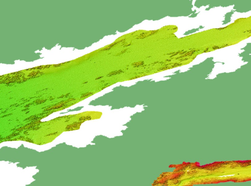
Morphological map (10 classes) of the Irish shelf resulting from the modal aggregation (Cell statistics “MAJORITY” in ArcGIS Pro 3.1) of the qualitatively and quantitatively best Fully Convolutional Neural Networks models obtained in the study: Arosio, R., Hobley, B., Wheeler, A. J., Sacchetti, F., Conti, L. A., Furey, T. and A. Lim, 2023. Fully convolutional neural networks applied to large-scale marine morphology mapping. Frontiers in Marine Science, Sec. Ocean Observation, 10, https://doi.org/10.3389/fmars.2023.1228867.
-

3-D habitat suitability maps (HSM) or probability of occurrence maps, built using Shape-Constrained Generalized Additive Models (SC-GAMs) for the 30 main commercial species of the Atlantic region. Predictor variables for each species were selected from: sea water temperature, salinity, nitrate, net primary productivity, distance to seafloor, distance to coast, and relative position to mixed layer depth. Each species HSM contains 47 maps, one per depth level from 0 to 1000 m. Probability values of each map range from 0 (unsuitable habitat) to 1 (optimal habitat). For depth levels below the 0.99 quantile of the depth values found on the species occurrence data, NA values were assigned. Maps have been masked to species native range regions. See Valle et al. (2024) in Ecological Modelling 490:110632 (https://doi.org/10.1016/j.ecolmodel.2024.110632 ), for more details.
-
The INtegrated Mapping FOr the Sustainable Development of Ireland's MArine Resource (INFOMAR) programme is a joint venture between the Geological Survey of Ireland (GSI) and the Marine Institute (MI). The programme is the successor to the Irish National Seabed Survey (INSS) and concentrates on creating integrated mapping products related to the seabed. INFOMAR Seabed Samples Particle Size Analysis represent locations where samples have been taken and particle size analysis (PSA) carried out on samples. Sediment type classification based on percentage sand, mud and gravel (after Folk 1954). Every sediment is a mixture of grains of varying sizes. It groups grains into mud, sand and gravel on the basis of their diameter. The relative proportion of the grains in the three categories is then used to describe the sediment and is displayed in a diagram commonly called a “Folk triangle”. This classification has 15 terms to describe the seabed sediments. Samples from the seabed are taken by grab and box core sampling instruments. PSA is applied to determine the range of sediment sizes contained in the sample which can often reveal an insight about the processes operating in the depositional environment. The results show percentage gravels, sands, silt and mud present in the sample. This analysis is also used to determine if the sample is well or poorly sorted.
-
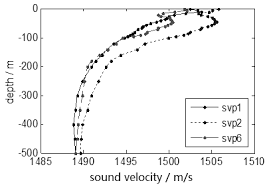
The INtegrated Mapping FOr the Sustainable Development of Ireland's MArine Resource (INFOMAR) programme is a joint venture between the Geological Survey of Ireland (GSI) and the Marine Institute (MI). The programme is the successor to the Irish National Seabed Survey (INSS) and concentrates on creating integrated mapping products related to the seabed. A sound velocity profile shows the speed of sound in water at different vertical levels. It has two general representations: 1. tabular form, with pairs of columns corresponding to ocean depth and the speed of sound at that depth, respectively. 2. a plot of the speed of sound in the ocean as a function of depth, where the vertical axis corresponds to the depth and the horizontal axis corresponds to the sound speed. By convention, the horizontal axis is placed at the top of the plot, and the vertical axis is labeled with values which increase from top to bottom, thus reproducing visually the ocean from its surface downward. A Sound Velocity Profile (SVP) is a measurement of the speed of sound in water. SVP data is collected during multi-beam surveying for calibration purposes to ground-truth the bathymetric and backscatter data collection. Data for SVP point locations and associated attribute values is generated from SVP profiler during survey. Data includes XY Longitude Latitude, Start SVP, End SVP, Maximum Depth, Data Quality and Comments, SVP Instrument Name and Survey Leg name.
-

The "EMODnet Digital Bathymetry (DTM) - 2016" is a multilayer bathymetric product for Europe’s sea basins covering:: • the Greater North Sea, including the Kattegat and stretches of water such as Fair Isle, Cromarty, Forth, Forties, Dover, Wight, and Portland • the English Channel and Celtic Seas • Western and Central Mediterranean Sea and Ionian Sea • Bay of Biscay, Iberian coast and North-East Atlantic • Adriatic Sea • Aegean - Levantine Sea (Eastern Mediterranean) • Azores - Madeira EEZ • Canary Islands • Baltic Sea • Black Sea • Norwegian – Icelandic seas The DTM is based upon more than 7700 bathymetric survey data sets and Composite DTMs that have been gathered from 27 data providers from 18 European countries and involving 169 data originators. The gathered survey data sets can be discovered and requested for access through the Common Data Index (CDI) data discovery and access service that also contains additional European survey data sets for global waters. This discovery service makes use of SeaDataNet standards and services and have been integrated in the EMODnet portal (https://emodnet.ec.europa.eu/en/bathymetry#bathymetry-services ). The Composite DTMs are described using the Sextant Catalogue Service that makes also use of SeaDataNet standards and services. Their metadata can retrieved through interrogating the Source Reference map in the Central Map Viewing service (https://emodnet.ec.europa.eu/geoviewer/ ). In addition, the EMODnet Map Viewer gives users wide functionality for viewing and downloading the EMODnet digital bathymetry such as: • water depth (refering to the Lowest Astronomical Tide Datum - LAT) in gridded form on a DTM grid of 1/8 * 1/8 arc minute of longitude and latitude (ca 230 * 230 meters) • option to view depth parameters of individual DTM cells and references to source data • option to download DTM in 16 tiles in different formats: EMO, EMO (without GEBCO data), ESRI ASCII, ESRI ASCII Mean Sea Level, XYZ, NetCDF (CF), RGB GeoTiff and SD • layer with a number of high resolution DTMs for coastal regions • layer with wrecks from the UKHO Wrecks database. The NetCDF (CF) DTM files are fit for use in a special 3D Viewer software package which is based on the existing open source NASA World Wind JSK application. It has been developed in the frame of the EU FP7 Geo-Seas project (another sibling of SeaDataNet for marine geological and geophysical data) and is freely available. The 3D viewer also supports the ingestion of WMS overlay maps. The SD files can also be used for 3D viewing by means of the freely available iView4De(Fledermaus) software. The original datasets themselves are not distributed but described in the metadata services, giving clear information about the background survey data used for the DTM, their access restrictions, originators and distributors and facilitating requests by users to originator.
-
The "EMODnet Digital Bathymetry (DTM) - 2016" is a multilayer bathymetric product for Europe’s sea basins covering:: • the Greater North Sea, including the Kattegat and stretches of water such as Fair Isle, Cromarty, Forth, Forties, Dover, Wight, and Portland • the English Channel and Celtic Seas • Western and Central Mediterranean Sea and Ionian Sea • Bay of Biscay, Iberian coast and North-East Atlantic • Adriatic Sea • Aegean - Levantine Sea (Eastern Mediterranean) • Azores - Madeira EEZ • Canary Islands • Baltic Sea • Black Sea • Norwegian – Icelandic seas The DTM is based upon more than 7700 bathymetric survey data sets and Composite DTMs that have been gathered from 27 data providers from 18 European countries and involving 169 data originators. The gathered survey data sets can be discovered and requested for access through the Common Data Index (CDI) data discovery and access service that also contains additional European survey data sets for global waters. This discovery service makes use of SeaDataNet standards and services and have been integrated in the EMODnet portal (https://emodnet.ec.europa.eu/en/bathymetry#bathymetry-services ). The Composite DTMs are described using the Sextant Catalogue Service that makes also use of SeaDataNet standards and services. Their metadata can retrieved through interrogating the Source Reference map in the Central Map Viewing service (https://emodnet.ec.europa.eu/geoviewer/ ). In addition, the EMODnet Map Viewer gives users wide functionality for viewing and downloading the EMODnet digital bathymetry such as: • water depth (refering to the Lowest Astronomical Tide Datum - LAT) in gridded form on a DTM grid of 1/8 * 1/8 arc minute of longitude and latitude (ca 230 * 230 meters) • option to view depth parameters of individual DTM cells and references to source data • option to download DTM in 16 tiles in different formats: EMO, EMO (without GEBCO data), ESRI ASCII, ESRI ASCII Mean Sea Level, XYZ, NetCDF (CF), RGB GeoTiff and SD • layer with a number of high resolution DTMs for coastal regions • layer with wrecks from the UKHO Wrecks database. The NetCDF (CF) DTM files are fit for use in a special 3D Viewer software package which is based on the existing open source NASA World Wind JSK application. It has been developed in the frame of the EU FP7 Geo-Seas project (another sibling of SeaDataNet for marine geological and geophysical data) and is freely available. The 3D viewer also supports the ingestion of WMS overlay maps. The SD files can also be used for 3D viewing by means of the freely available iView4De(Fledermaus) software. The original datasets themselves are not distributed but described in the metadata services, giving clear information about the background survey data used for the DTM, their access restrictions, originators and distributors and facilitating requests by users to originator.