 Metadata catalogue
CDS-SAT-AVISO
Type of resources
Available actions
Topics
Keywords
Provided by
Representation types
-
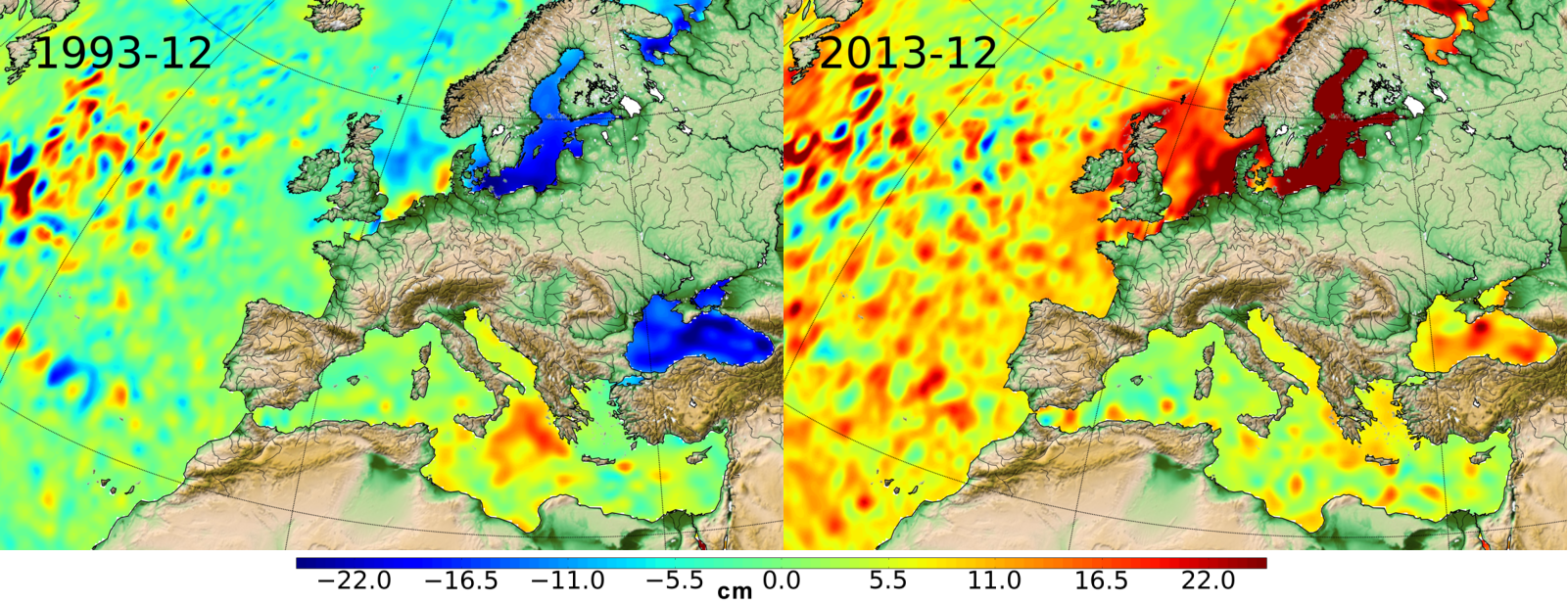
Ssalto/Duacs multimission gridded sea surface heights products. From January 1993 to the last extension of the Delayed-time products, the long delayed-time dataset allows to compute statistical means of Maps of Sea Level Anomalies (MSLA) over different periods of time. Computed with respect to a twenty-year mean profile [1993-2012], and including the seasonal variability (no annual cycle is removed).
-

Monomission Sentinel-3A altimetry product, LR-RMC mode (Low-Resolution with Range Migration Correction) with along-track level-2 estimations at 20Hz rate in LR-RMC mode. LR-RMC associated waveforms are also included, as well with the geophysical corrections applied to the altimeter range (SGDR files).
-

The Ocean Heat Content ("OHC") is estimated from the measurement of the thermal expansion of the ocean based on differences between the total sea-level content derived from altimetry measurements and the mass content derived from gravimetry data, noted “altimetry-gravimetry”. The Earth Energy Imbalance ("EEI") indicator is derived from the temporal variations of the ocean heat content, i.e. by calculating its derivative (called the ocean heat uptake). A single NetCDF file provides all variables, including all data used to calculate the Ocean Heat Content and the Earth Energy Imbalance indicators, delivered transparently and allowing users to reconstruct their own Ocean Heat Content or Earth Energy Imbalance indicators. Users will therefore be able to find, among other things : - the regional map of the Ocean Heat Content trends (3°x3°) (see image associated with this metadata sheet) - global ocean heat content time series (representative of the globe within the extent of data availability) - earth energy imbalance time series (from global OHC filtered-out from signals lower than 3 years)
-
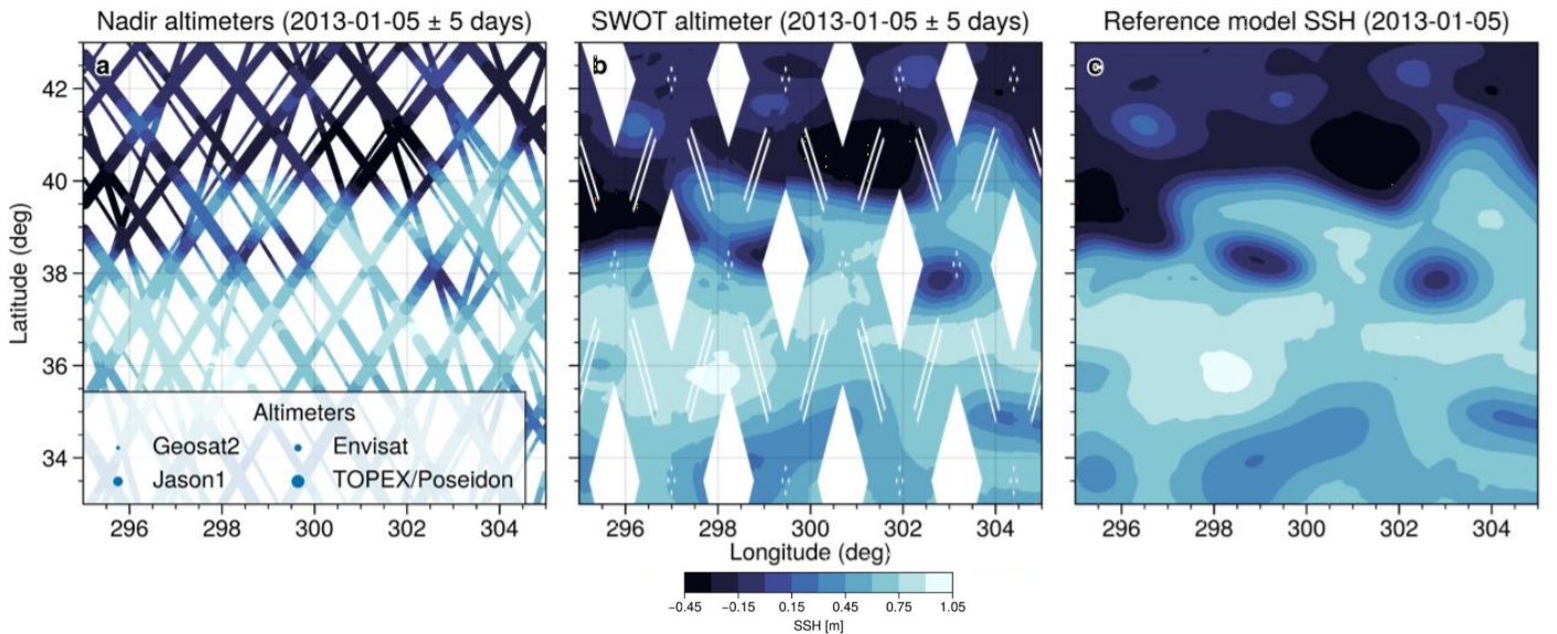
This simulated products "2020A_SSH_MAPPING_NATL60" (SWOT BOOST Data Challenge) are model-based Sea Surface Height (SSH) products and contain Sea Surface Height data simulated on 1) several along-track altimeter orbits (Jason1, Envisat, Geosat2, Topex/Poseidon interleaved and SWOT-nadir orbits - which is not currently in orbit) and 2) the large-swath of SWOT (not currently in orbit). These SSH data are interpolated onto the orbits thanks to the SWOTSimulator package from a realistic high resolution ocean simulation.
-
Significant Wave Height (SWH) monomission along-track altimeter satellite product available for Sentinel-3A and Sentinel-3B missions in Near-Real-Time. SWH values are computed from the High Resolution Mode, also known as Synthetic Aperture Radar mode (SAR) and are calibrated relative to buoys. A validity flag and the applied correction are also provided. Since April 2021, a new variable is included in the files : wind speed, computed by Gourrion (2002) algorithm using Collard (2005) table with PLRM sigma0 and SWH. Moreover, the values are cross-calibrated with Jason-3 standard F wind speed.
-
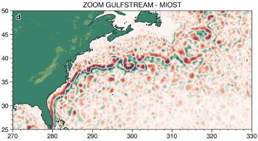
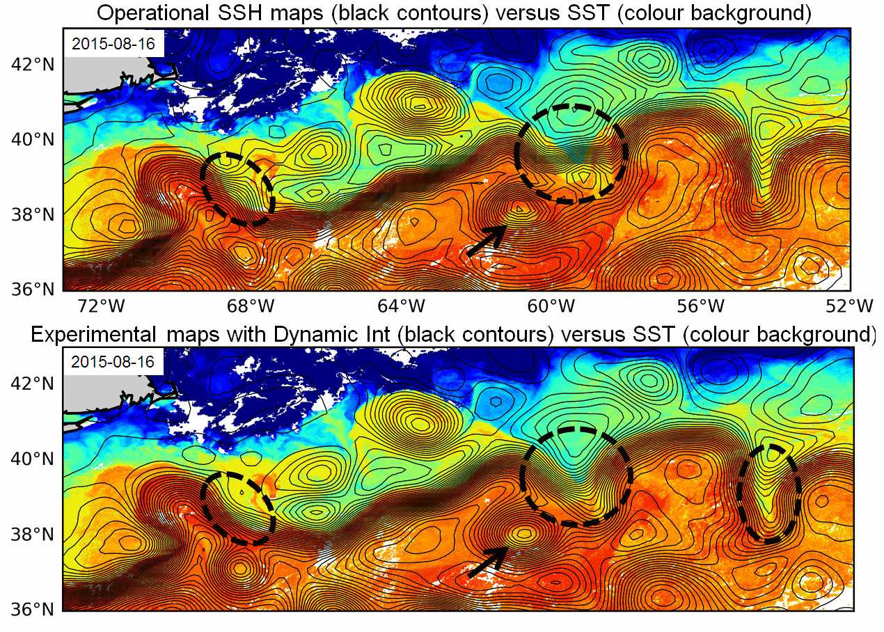
The MIOST (Multiscale Interpolation Ocean Science Topography) experimental altimeter product provides grids at delayed-time, at global scale, 1/10° spatial resolution, the sea surface height (MSLA and MADT) as well as the geostrophic currents, resulting from specific processing. Use for regional studies, ocean variability (mesoscale circulation,...).
-
Multimission altimeter products "Experimental" with a finer resolution in preparation to the SWOT Era with sea surface heights computed with respect to a twenty-year mean and Geostrophic velocities, resulting from specific processes, available in delayed time. Use: regional studies, ocean variability (mesoscale circulation,...),