 Metadata catalogue
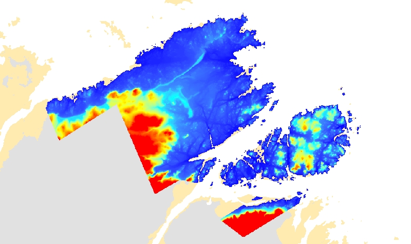
Brest
Type of resources
Available actions
Topics
INSPIRE themes
Keywords
Contact for the resource
Provided by
Years
Formats
Representation types
Update frequencies
status
Scale
Resolution
-
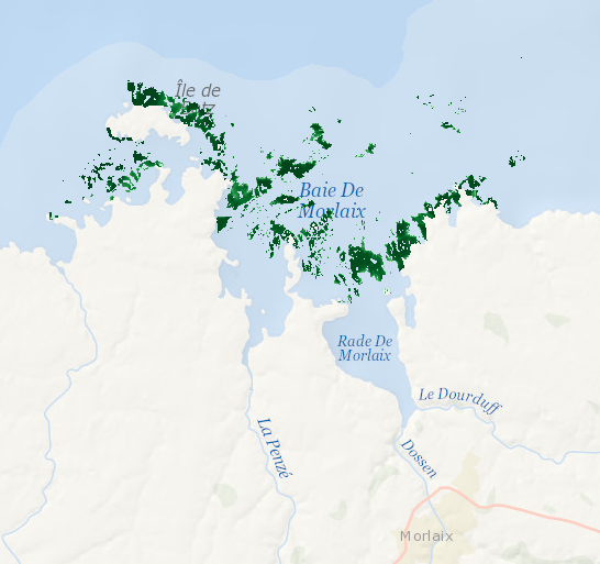
Data represents presence-absence prediction of kelp forest. Biological ground truth data were integrated with high resolution environmental datasets to develop statistical model that accurately predict the structure of Laminaria forests within the Bay of Morlaix. As a direct management output, high-resolution map (25 m2 grid) was produced.
-

La couche contient des objets de type point contenant des informations sur les installations portuaires appartement à la région Bretagne (Lorient, Saint-Malo et Brest) : aires de carénage, bureaux, bars, chantiers navals, déchets, exutoires, manutention, embarcadères, parkings, fonctionnement portuaire, etc.
-
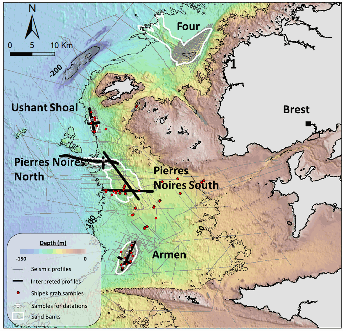
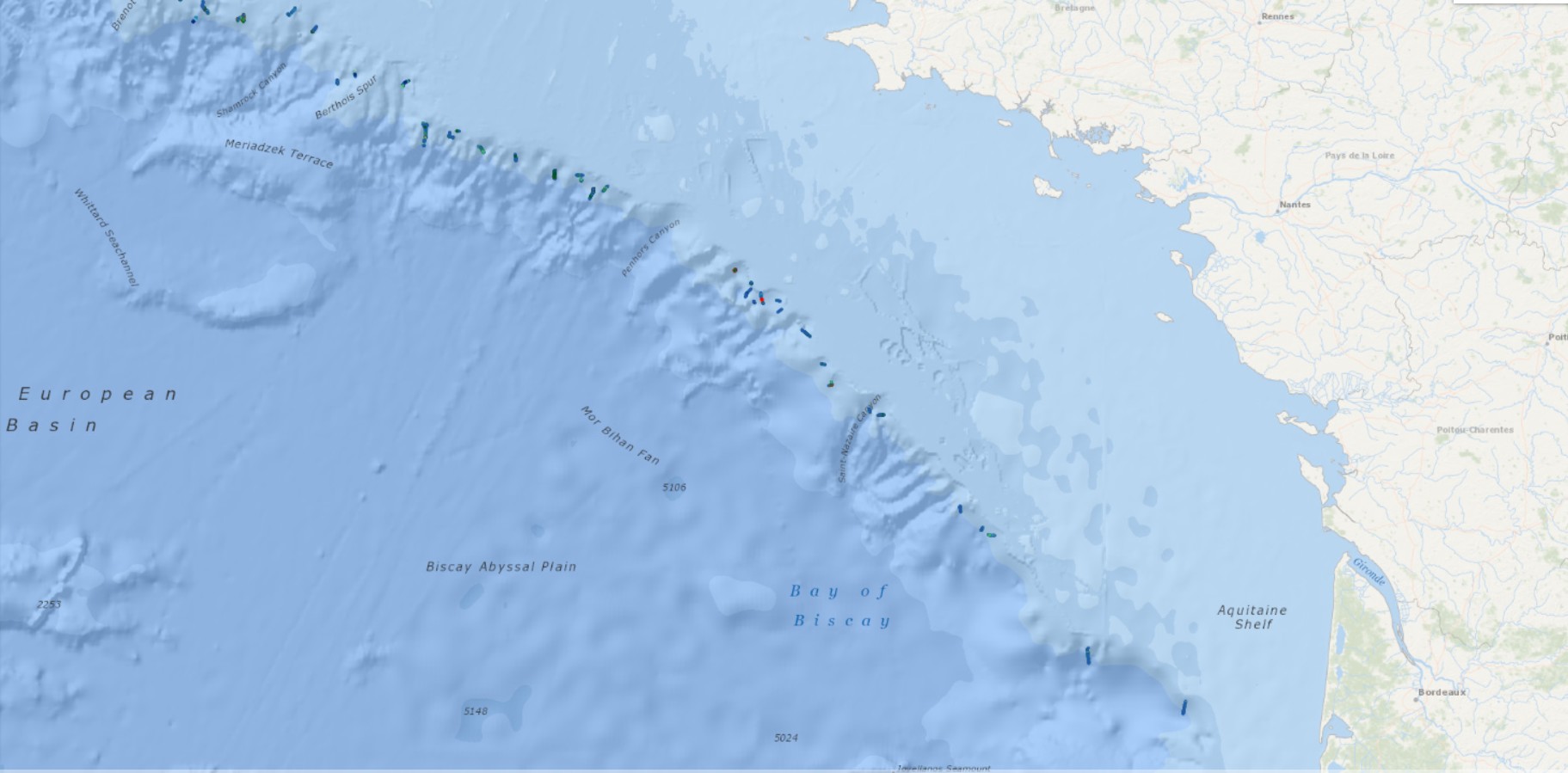
This seismic dataset came from surveys carried out by the “Institut Universitaire Européen de la Mer” (IUEM, UBO) and the Ifremer, on the Iroise Sea platform, (Western Brittany, France). Two main files are provided here: -The first one is composed of the 10 seismic profiles described in the article "Long term evolution of deep banner banks offshore Western Brittany (Iroise Sea, France): indications of a paleo-coast line and of the interaction between hydrodynamics and seafloor morphology", with tiff and SEG Y / NAV data. The second is composed of SEGY files over the whole platform from several research cruises (GEOBREST (11, 12, 13, 14,15, 19), SpeeDunes, Bankable, SABASETI). .Nav files are the XY coordinates of each seismic line. For each SEGY fil there is both a non-corrected and a corrected version (name of the file finishing by PRC).Each data file is accompanied by other files with the same name (for example .GEO .PRM ...) that are necessary to open the corrected version. An integrated approach combining seismic, bathymetry and sediment analyses acquired over the last 10 years aims to understand the main factors driving the sand banks growth and internal architecture, as well as their anchoring and stability at a depth of almost -100m since the last deglaciation.
-
Les communes concernées par l'application de la "loi Littoral" sont définies par l’article L. 321-2 du code de l’environnement comme les communes de métropole et des départements d'outre-mer : Article L321-2 Sont considérées comme communes littorales, au sens du présent chapitre, les communes de métropole et des départements d'outre-mer : 1° Riveraines des mers et océans, des étangs salés, des plans d'eau intérieurs d'une superficie supérieure à 1 000 hectares ; 2° Riveraines des estuaires et des deltas lorsqu'elles sont situées en aval de la limite de salure des eaux et participent aux équilibres économiques et écologiques littoraux. La liste de ces communes est fixée par décret en Conseil d’État, après consultation des conseils municipaux intéressés. Une commune est considérée comme riveraine de la mer et des océans dès lors qu'une partie, même réduite, de son territoire jouxte le rivage de la mer.
-
Les aires marines protégées (ou AMP) sont des espaces délimités en mer qui répondent à des objectifs de protection de la nature à long terme. La plupart des AMP permettent de concilier les enjeux de protection et le développement durable d'activités. Leurs modes de gouvernance associent le plus souvent les usagers, les élus, les experts... à la gestion de l'espace marin identifié. Le code de l'environnement (article L334-1) reconnaît différentes catégories d'aires marines protégées qui répondent chacune à des objectifs propres tout en étant complémentaires. La donnée des périmètres des AMP est tenue par l'ensemble des géomaticiens du pôle géomatique mer et littoral de l'Office français de la biodiversité.
-
Données de relief acquises par levé au laser aéroporté. La donnée se présente sous la forme de 28 couches maillées de résolution 1*1 mètres, au format Grid ArcInfo. L'altitude est exprimée en mètre (positif vers le zénith) par rapport au référentiel IGN69. Ce MNT est issu de données source de type "first pulse" (i.e. sol, bâtiments, sommet de la végétation), acquises fin 2002. La méthode d'interpolation employée est le krigeage.
-
La cartographie des habitats marins profonds du golfe de Gascogne a été réalisée par le laboratoire Environnement Profond de l'Ifremer dans le cadre du projet CoralFish et d'une convention entre l'Ifremer et l'Agence des Aires Marines Protégées. La méthode employée pour cette cartographie des habitats repose sur le dépouillement préalable des vidéos et des images acquises grâce au ROV Victor 6000 et à la caméra tractée SCAMPI dans le cadre de plusieurs campagnes océanographiques : BOBGEO1 (du 14/10/2009 au 28/10/2009, chef de mission : Jean-François BOURILLET), EVHOE 2009 (du 18/10/2009 au 01/12/2009, chefs de mission : Jean-Pierre LEAUTE et Michèle SALAUN), BOBGEO2 (du 18/07/2010 au 25/07/2010, chef de mission : Jean-François BOURILLET, Ifremer Brest), EVHOE 2010 (du 18/10/2010 au 02/12/2010, chefs de mission : Jean-Pierre LEAUTE et Michèle SALAUN), BOBECO (du 9/09/2011 au 11/10/2011, chefs de mission : Sophie ARNAUD-HAOND et Anthony GREHAN) et EVHOE 2012 (du 18/10/2012 au 02/12/2012, chefs de mission : Jean-Pierre LEAUTE et Michèle SALAUN). Les habitats observés ont été définis selon la typologie CoralFish (Davies et al. 2017) et délimités en fonction des observations faites sur les images et profils vidéos. Dans le cadre de cette cartographie, il a été décidé de conserver uniquement les habitats d'une superficie d'au minimum 25m², soit des segments d'au moins 5 mètres de long, définis par au minimum 2 observations identiques contigües. Puis, aux habitats du niveau 3 de la classification CoralFish, ont été associés les habitats de la typologie nationale (HABREF, Michez et al. 2019) et les habitats de typologie internationales, en particulier les Ecosystèmes Marins Vulnérables (VME, ICES 2020), l'habitat récif '1170' au sens de la directive européenne Habitat Faune Flore, et la liste OSPAR des espèces et habitats menacés et/ou en déclin. Références : Davies, J.S., Guillaumont, B., Tempera, F., Vertino, A., Beuck, L., Ólafsdóttir, S.H., Smith, C.J., Fosså, J.H., van den Beld, I.M.J., Savini, A., Rengstorf, A., Bayle, C., Bourillet, J.F., Arnaud-Haond, S., Grehan, A., 2017. A new classification scheme of European cold-water coral habitats: Implications for ecosystem-based management of the deep sea. Deep Sea Research Part II: Topical Studies in Oceanography 145: 102-109, 10.1016/j.dsr2.2017.04.014. Michez, N., Thiébaut, E., Dubois, S., Le Gall, L., Dauvin, J.-C., Andersen, A.C., Baffreau, A., Bajjouk, T., Blanchet, H., de Bettinies, T., De Casamajor, M.-N., Derrien-Courtel, S., Houbin, C., Janson, A.-L., La Rivière, M., Lévèque, L., Menot, L., Sauriau, P.-G., Simon, N., Viard, F., 2019. Typologie des habitats marins benthiques de la Manche, de la Mer du Nord et de l’Atlantique. VERSION 3. ICES, 2020. ICES/NAFO Joint Working Group on Deep-water Ecology (WGDEC). ICES Scientific Reports 2 (62), 171, 10.17895/ices.pub.7503.
-
The GEBCO_2022 Grid is a global continuous terrain model for ocean and land with a spatial resolution of 15 arc seconds. In regions outside of the Arctic Ocean area, the grid uses as a base Version 2.4 of the SRTM15_plus data set (Tozer, B. et al, 2019). This data set is a fusion of land topography with measured and estimated seafloor topography. Included on top of this base grid are gridded bathymetric data sets developed by the four Regional Centers of The Nippon Foundation-GEBCO Seabed 2030 Project. The GEBCO_2022 Grid represents all data within the 2022 compilation. The compilation of the GEBCO_2022 Grid was carried out at the Seabed 2030 Global Center, hosted at the National Oceanography Centre, UK, with the aim of producing a seamless global terrain model. Outside of Polar regions, the Regional Centers provide their data sets as sparse grids i.e. only grid cells that contain data are populated. These data sets were included on to the base using a remove-restore blending procedure. This is a two-stage process of computing the difference between the new data and the base grid and then gridding the difference and adding the difference back to the existing base grid. The aim is to achieve a smooth transition between the new and base data sets with the minimum of perturbation of the existing base data set. The data sets supplied in the form of complete grids (primarily areas north of 60N and south of 50S) were included using feather blending techniques from GlobalMapper software. The GEBCO_2022 Grid has been developed through the Nippon Foundation-GEBCO Seabed 2030 Project. This is a collaborative project between the Nippon Foundation of Japan and the General Bathymetric Chart of the Oceans (GEBCO). It aims to bring together all available bathymetric data to produce the definitive map of the world ocean floor by 2030 and make it available to all. Funded by the Nippon Foundation, the four Seabed 2030 Regional Centers include the Southern Ocean - hosted at the Alfred Wegener Institute, Germany; South and West Pacific Ocean - hosted at the National Institute of Water and Atmospheric Research, New Zealand; Atlantic and Indian Oceans - hosted at the Lamont-Doherty Earth Observatory, Columbia University, USA; Arctic and North Pacific Oceans - hosted at Stockholm University, Sweden and the Center for Coastal and Ocean Mapping at the University of New Hampshire, USA.
-
The GEBCO grid is global data set of elevation values, in metres, on a 15 arc-second interval grid. It is accompanied by a Type Identifier (TID) Grid that gives information on the types of source data that the GEBCO_2024 Grid is based on. An additional 4.34 million square kilometres of bathymetric data has been added to the global grid since the last release in 2023, with 26.1% of the seabed now mapped. This is the Sixth GEBCO grid developed through the Nippon Foundation-GEBCO Seabed 2030 Project.This is a collaborative project between the Nippon Foundation of Japan and GEBCO. The aim of the project is to map the global sea floor by 2030. GEBCO's grids can be downloaded as a global file in netCDF format or for user-defined areas, through our download app, in netCDF, data GeoTiff and ESRI ASCII raster formats. The data set can also be downloaded in the form of imagery. This release of the GEBCO grid includes data from version 5.0 of the International Bathymetric Chart of the Arctic Ocean (IBCAO) . GEBCO's aim is to provide the most authoritative publicly-available bathymetry of the world's oceans. It operates under the joint auspices of the International Hydrographic Organization (IHO) and the Intergovernmental Oceanographic Commission (IOC) (of UNESCO).
-
The GEBCO_2021 Grid is a global continuous terrain model for ocean and land with a spatial resolution of 15 arc seconds. This is the third GEBCO grid produced through the framework of the Nippon Foundation-GEBCO Seabed 2030 Project. The aim of the project is to map the global sea floor by 2030. For the 2021 release of the GEBCO grid, it is estimated that 20.6% of seafloor has now been mapped, this is an increase from 19% for the previous release, GEBCO_2020. The GEBCO_2021 Grid uses as a ‘base’ Version 2.2 of the SRTM15+ data set between latitudes of 50° South and 60° North. This data set is a fusion of land topography with measured and estimated seafloor topography. The base grid has been augmented with the gridded bathymetric data sets developed by the four Seabed 2030 Regional Centers to produce the global GEBCO grid. The primary GEBCO_2021 grid contains land and ice surface elevation information - as provided for previous GEBCO grid releases. In addition, for the 2021 release, we have made available a version with under-ice topography/bathymetry information for Greenland and Antarctica. GEBCO's aim is to provide the most authoritative publicly-available bathymetry of the world's oceans. It operates under the joint auspices of the International Hydrographic Organization (IHO) and the Intergovernmental Oceanographic Commission (IOC) (of UNESCO).