 Metadata catalogue
Bathymetry and Elevation
Type of resources
Available actions
Topics
INSPIRE themes
Keywords
Contact for the resource
Provided by
Years
Formats
Representation types
Update frequencies
Scale
Resolution
-
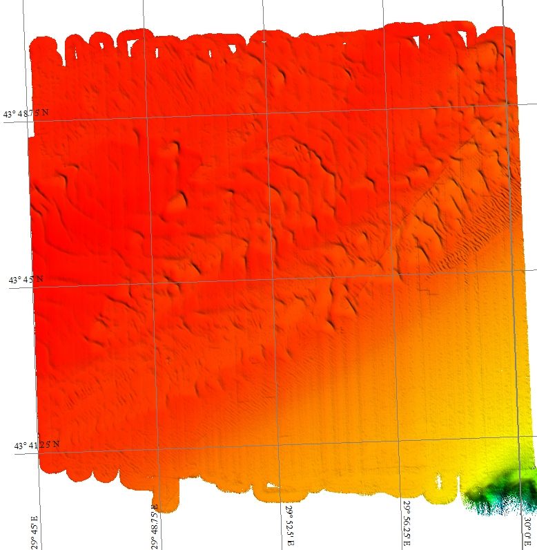
Romanian national mapping of the continental platform
-

Satellite-derived intertidal bathymetry for the Danish Wadden on the West coast of Denmark
-

Satellite-derived intertidal bathymetry for the Tagus estuary near Lisbon Portugal
-
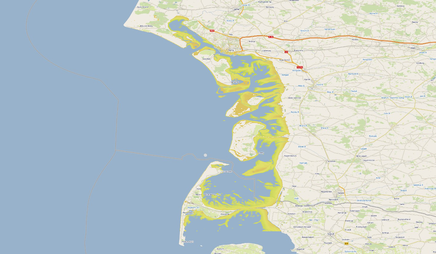
Satellite-derived intertidal bathymetry for the Danish Wadden on the West coast of Denmark
-
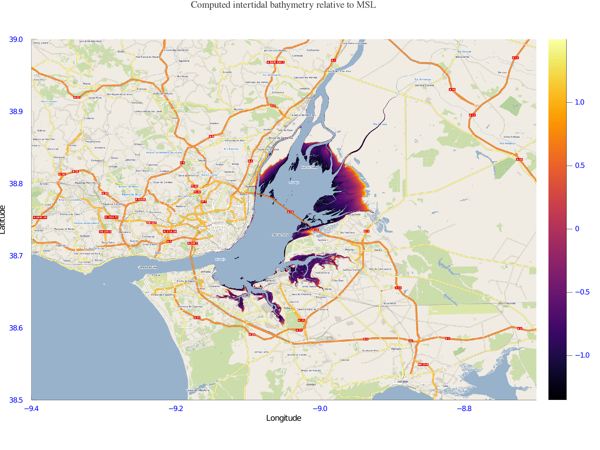
Satellite-derived intertidal bathymetry for the Tagus estuary near Lisbon Portugal
-

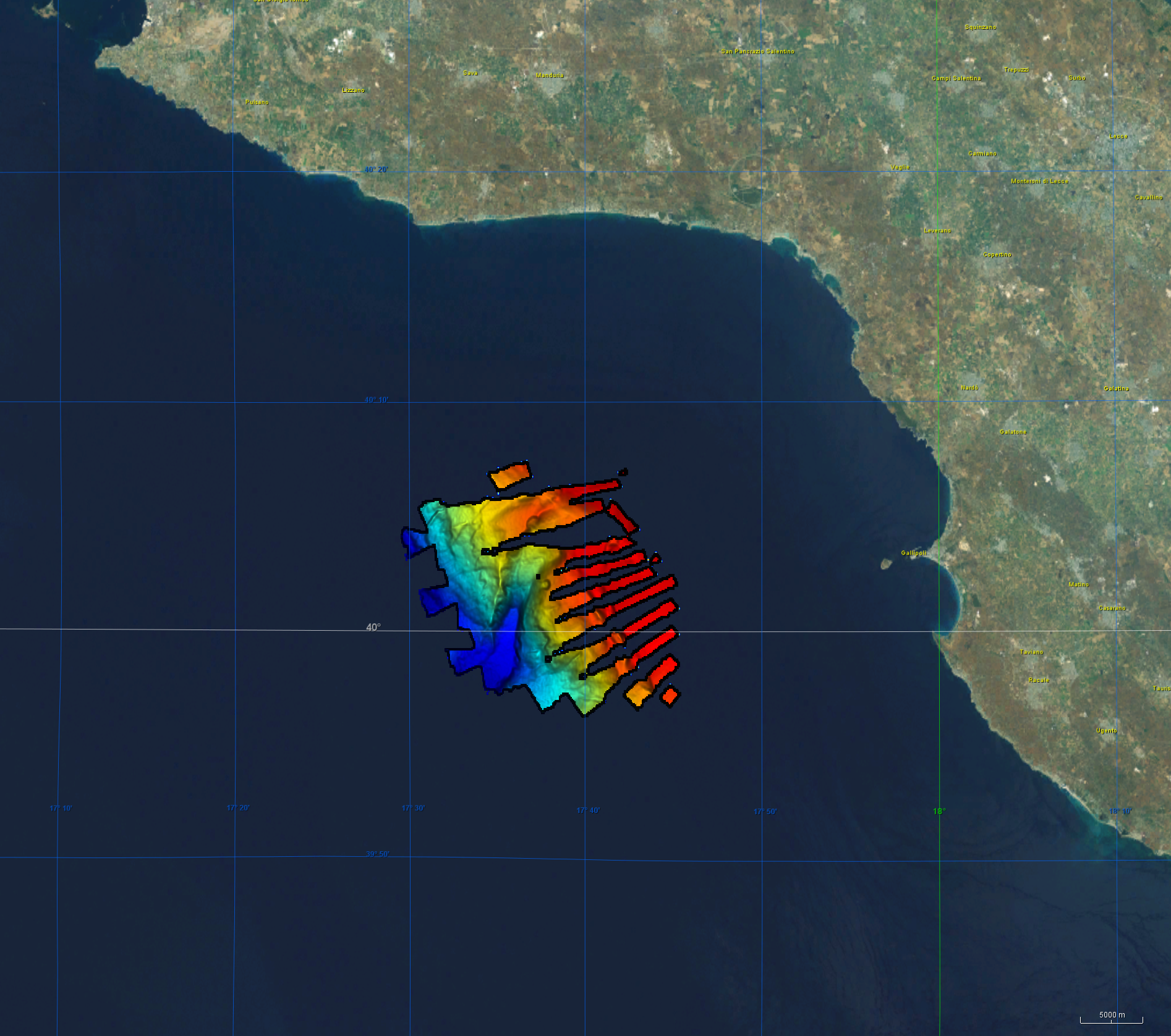
Gridded multibeam data acquired during scientific surveys and transits of French research vessels from 1992 to 2017 off the French Caribbean Islands.
-
Bathymetry data was acquired during R/V Meteor cruise M144/1 in the aegean region of the Mediterranean Sea between 27.12.2017 and 18.01.2018. The cruise aimed to clarify the causal links between climate and ecosystem change on the one hand by sociocultural evolution on the other hand by climatic and environmental change that can be aligned with the archeological record. CI Citation: Paul Wintersteller (seafloor-imaging@marum.de) as responsible party for bathymetry raw data ingest and approval. Description of data source: During the M144/1 cruise, the hull-mounted KONGSBERG EM122 multibeam ecosounder (MBES) was utilized to perform bathymetric mapping in medium to deep waters. Two linear transducer arrays in a Mills Cross configuration transmit acoustic signals of a nominal sonar frequency of 12 kHz. With 432 soundings per swath, the emission cone has a dimension of max 150° across track and 1° along track. With a reception obtained from 288 beams, the actual beam footprint is 1° by 2°. Depending on the roughness of the seafloor and the water depth, the swath width on a flat bottom is maximum six times the water depth. For further information on the system, consult https://www.km.kongsberg.com/. The position and depth of the water column is estimated for each beam by using the detected two-way-travel time and the beam angle, ray-traced through the water column, utilizing a proper sound speed profile. Throughout this cruise the swath width was mainly at 120° and did not exceed 130°. Responsible person during this cruise / PI: unstated.
-
The coastal heights data combines two datasets: the land-sea mask of the gridded EMODnet bathymetry and the height of high-water (HAT) relative to chart datum (LAT) as computed with the GTSM tide model. Near the coast a diffusion scheme is applied to make the heights consistent with the land-sea mask. Finally, only grid cells that are classified as sea, but neighbor a land cell are selected. The main assumption in this approach is that the height of the topography near the coastline is close to the high-water mark. The main purpose of this dataset is to improve extrapolation towards the coast. In many areas around Europe there is a (small) gap between the point closest to the coast for which a survey is available and the coastline. In this way interpolation from coarser background data is avoided.
-
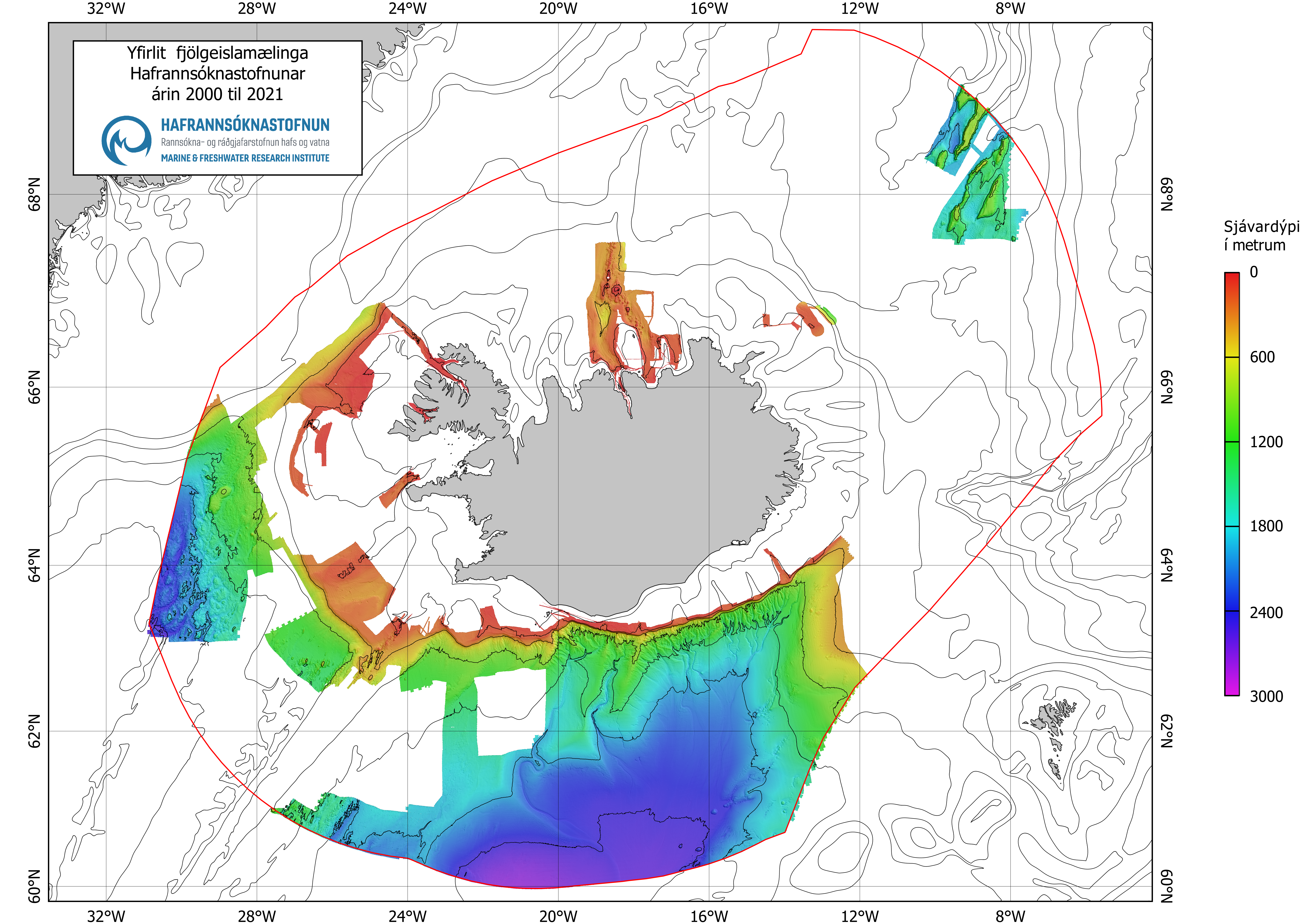
Seabed mapping is one of the Marine and Freshwater Research Institute´s projects which started with the launching of the research vessel, Arni Fridriksson RE 200, in the year 2000. The vessel is equipped with a multibeam echo sounder which enables a detailed mapping of the seabed. Until spring 2017 the multibeam echo sounder was of the type Kongsberg EM 300 (30 kHz, 135 beams, 2°x2°) but was then updated to Kongsberg EM 302 (30 kHz, 432 beams, 1°x2°, water column data). From the year 2017 the seabed mapping project is one of MFRI´s major initiatives for the next 12 years. The main emphasis is to gain information within the economic zone which is useful for multifaceted purpose and is a prerequisite for scientific approach for sustainable utilization, protection and research of resources in the ocean.
-
Data has been derived from charted numbers