 Metadata catalogue
Bathymetry
Type of resources
Available actions
Topics
INSPIRE themes
Keywords
Contact for the resource
Provided by
Years
Formats
Representation types
Update frequencies
status
Service types
Scale
Resolution
-

Bathymetry grid, with a pixel resolution of 25 m, from bathymetry data acquired during the 2010 Bathysaintes cruise (https://doi.org/10.17600/10030020). Data were controlled and processed with the Ifremer Caraibes software.
-
Bathymetry grid, with a pixel resolution of 10 m, from bathymetry data acquired during the 2010 Bathysaintes cruise (https://doi.org/10.17600/10030020). Data were controlled and processed with the Ifremer Caraibes software.
-
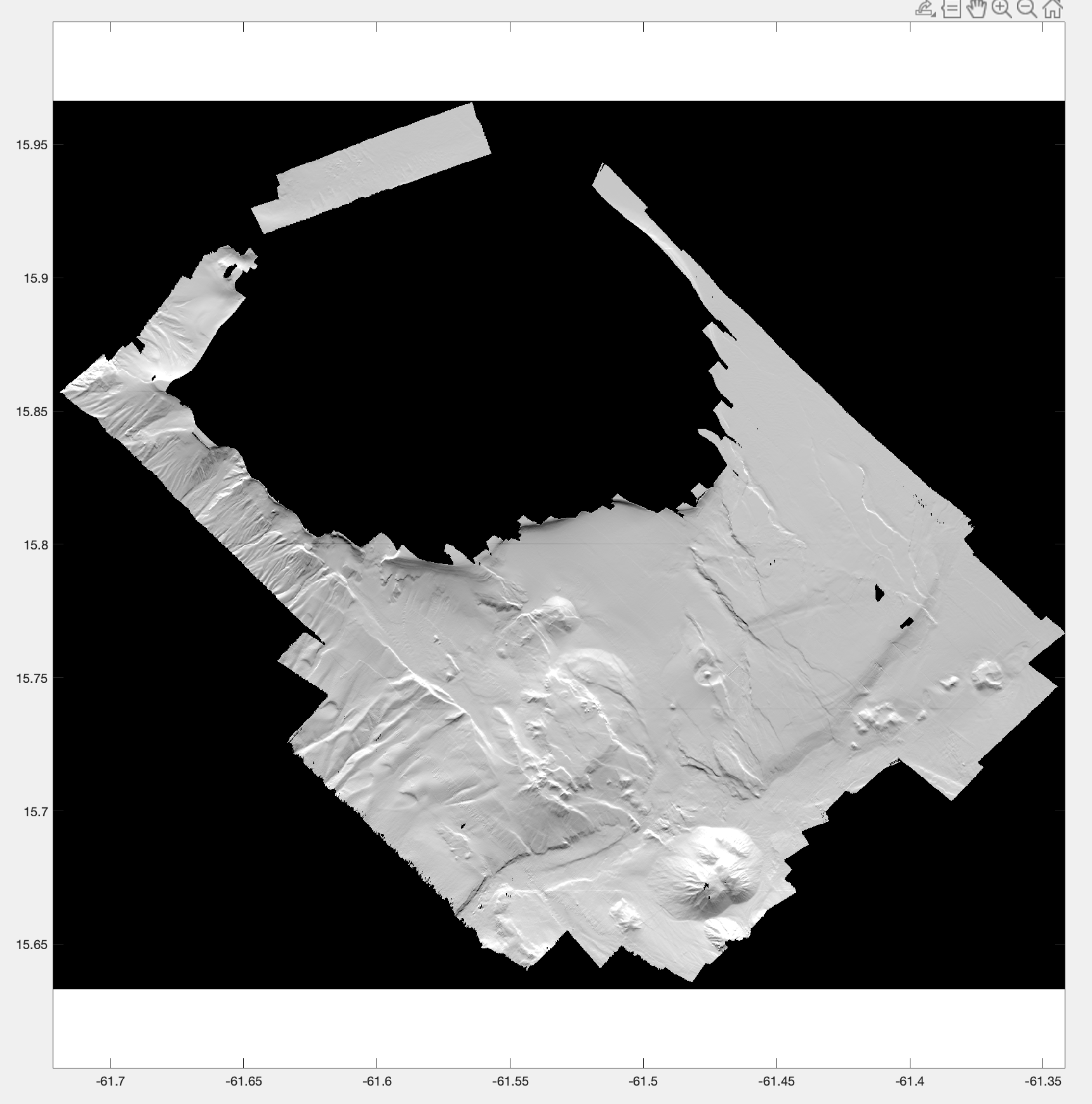
ROV3G scientific cruise is dedicated to the morpho-tectonic study of the ligurian shelf, through the acquisition of bathymetric data and optical images with HROV Ariane. This cruise took place on R/V Europe in october 2021, and constituted a pedagogic project for the students of Master 3G Recherche, Géologie et Géophysique, of Université Côte d'Azur (UCA), attached to Géoazur lab. The M2 students were in charge of the scientific project, they determined the goals of the cruise, took part in the acquisition and interpretation of the data. During the 3 days cruise, we acquired bathymetric data at shallow depth on the continental shelf offshore Santo Stefano al Mare and San Lorenzo al Mare, along the Ligurian coast. The bathymetry on the continental shelf exhibits morphologies that are probably related to the Flyschs formation that is outcroping onshore (Stani et al., 2010), and that is partially capped by late quaternary deposits (as identified in seismic data and interpreted in Bozzano et al., 2006). Ridges identified as paleo-shorelines (paleo-beaches?) have been investigated with HROV ariane whose navigation is also published here. Videos are available on video.ifremer.fr Here we publish two bathymetric grids at high-resolution, calculated from the ME70 multibeam echosounder of R/V Europe, using GLOBE software (Poncelet et al., 2022). The shallowest part of the plateau is gridded in a 5 m digital elevation model (DEM), while the entire survey area is gridded at 10m resolution. The back-scatter maps, gridded at 6 m, produced with Sonarscope software (Augustin et al., 2022), are also available (raw and compensated). All grids are in WGS84 (EPSG:4326). The cruise report (written in french) is also available.
-
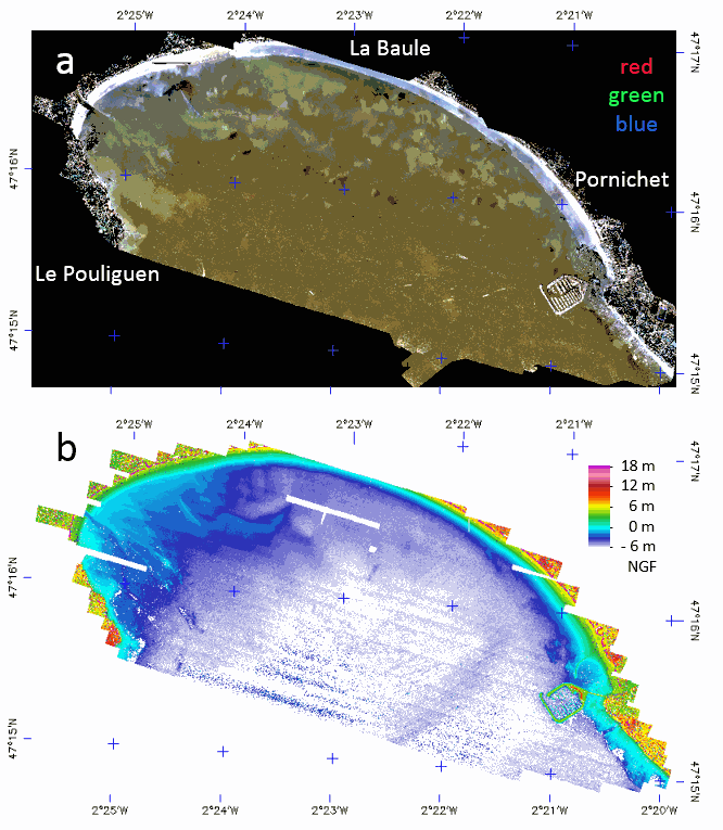
The LiDAR used is the Titan DW 600 from Teledyne Optech of the “Platform topo-bathymétrique aéroportée Nantes-Rennes”. Both 532-nm and 1064-nm LiDAR swath were acquired 6th and 7th of October 2017, at 400 m above ground with a FOV of 28° giving strip image width of 199.5 m with a nominal footprint of 0.49 m along-track and 0.29 m cross-track. A mirror compensation and a sidelap of 30% was used to prevent empty space between strips. The effective incident angle range was from 4 to 20°. The aircraft speed being 201.7 km/h the down track footprint rise up to 0.98 m on sideway what justify a final spatial resolution of 1 m. The laser pulse frequency was set to 50 kHz (100 kHz locally) giving an overall mean point density of 3.52 points/m². The full-waveform (FWF) was recorded only in 532-nm with a maximum length of 60 m, at 1 GHz frequency, resulting in a vertical resolution of 0.15 m. The Optech LiDAR Mapping Suite (LMS) combines a Global Positioning System (GPS) and Inertial Measurement Unit (IMU) to provide a georeferenced point cloud and associated FWF with strip optimization. To compute the complete point cloud, LMS uses an analogous approach to photogrammetric block adjustment. On overlap areas between each flight line, planes (typically roofs in land) are extracted and used in a least squares adjustment model provided by LMS. The trajectory accuracy provided by GEOFIT Company was better than 0.15 m in planimetry and 0.08 m on elevation. The set of data is stored in a zip file composed of the following image files associated with ENVI headers which are text files describing the image format. - LaBaule_2017106-7-orthophoto: contain the mosaic of RGB image acquired with the camera associated to the LiDAR. - LaBaule_2017106-7_536nm_raytracing-incident_angles_2m: contains the effective incident angle of each pixel retained in the mosaic with a pixel FOV of 0.3° and with a tilling of image strips in the top of each other from the North to the South. - LaBaule_2017106-7_1064nm_raytracing_discrete_echo_ranges_2m: contains the elevation of the water surface of each pixel. - LaBaule_2017106-7_536nm_raytracing_FWF_2m: contains the row FWF projected on the image plane at 0 m NGF with an offset of 30 m for easy spectral processing of the FWF (true range are stored in band names). - LaBaule_2017106-7_536nm_raytracing_FWF_2m_intensity_stats: contains the basic statistics of the FWF intensities. - LaBaule_2017106-7_536nm_raytracing_FWF_2m_range_stats: contains the min, max and thickness of the FWF ranges. - LaBaule_2017106-7_536nm_raytracing_FWF_2m_row_results: contains the row results of water surface and method 1 (dddNCFWF echoes) and method 2 (NCFWFT-1 bottoms) bathymetries as defined in https://doi.org/10.3390/rs11020117. - LaBaule_2017106-7_536nm_raytracing_FWF_4m_final_bathymetry: contains the final (cleaned NCFWFT-1 bottoms) bathymetry. The same data were acquired the 11th of August 2018 during a low tide with the same settings without RGB camera but with a new FWF recorder giving a lot less noisy signal allowing a constant spatial resolution of 1 m. The set of data is stored in a zip file composed of the following image files associated with ENVI headers which are text files describing the image format. - LaBaule_20180811_536nm_raytracing-incident_angles_1m: contains now 3 channels for the effective incident angle, the strip number and the GPS time. - LaBaule_20180811_1064nm_raytracing_discrete_echo_ranges_1m: contains the elevation of the water surface and all echoes above it in each pixel. - LaBaule_20180811_536nm_raytracing_FWF_1m: contains the row FWF projected on the image plane at 0 m NGF with an offset of 30 m for easy spectral processing of the FWF (true range are stored in band names). - LaBaule_20180811_536nm_raytracing_FWF_1m_intensity_stats: contains the basic statistics of the FWF intensities. - LaBaule_20180811_536nm_raytracing_FWF_1m_range_stats: contains the min, max and thickness of the FWF ranges. - LaBaule_20180811_536nm_raytracing_FWF_1m_row_results: contains the row results of water surface and method 1 (dddNCFWF echoes) and method 2 (NCFWFT-1 bottoms) bathymetries as defined in https://doi.org/10.3390/rs11020117. - LaBaule_20180811_536nm_raytracing_FWF_1m_final_bathymetry: contains the best of dddNCFWF echoes and NCFWFT-1 bottoms simply presented with the application of a 5x5 median filter. -
-
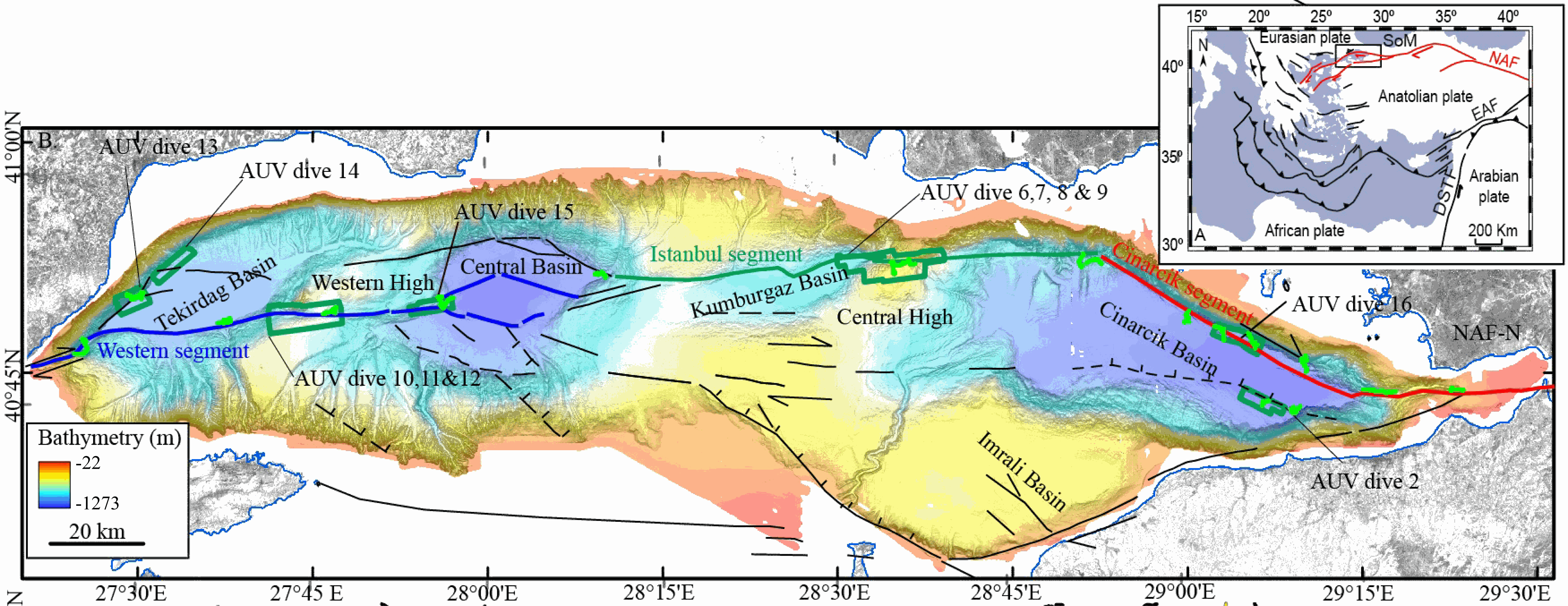
This data set contains processed multibeam sounder data from 12 dives of AsterX AUV performed on active faults scarps of the North Anatolian Fault system in the Sea of Marmara during the Marmesonet cruise (2009). The AUV carried a SIMRAD EM2000 multibeam echosounder, operating at 200 kHz, and surveyed at 50 to 70 m altitude, allowing a swath width of 150-200 m. Digital Elevation Models (DEM, in meters below sealevel) and seafloor backscatter intensity mosaics (relative amplitude in dB) are provided for 7 zones: Tekirdağ Basin W (dive 13), Tekirdağ Basin NW (dive 14), Western High (dives 10, 11 and 12), Western High E (dive 15), Central High (dive 6,7,8 and 9), Çınarcık Basin N (dive 16), Çınarcık Basin S (dive 2) (see figure). The horizontal resolution and grid pixel size of the DEM is 2 m. That of the backscatter intensity image is 1 m. Two versions of the DEM are provided. Version 1 is consistent with the backscatter image. Version 2 was updated applying a Fofonoff correction to the depths and relocating part of the AUV multibeam sounding points to fit EM302 shipborne multibeam maps. Version 2 depths and absolute positions are more accurate (10 m in the WGS-84 reference frame), but Version 1 will give better results if the backscatter image is applied as a texture or shading on the DEM. DEM and Backscatter raster files are provided in GeoTIFF format (readable with ArcGis 10.3 and QGIS 3) and use projected cartesian coordinates. They were converted from CARAIBES (Ifremer bathymetry and imagery processing software) output raster files with QGIS using GDAL translator. The Coordinate Reference System is a world Mercator projection based on WGS-84 datum, using meter units and a standard parallel at N40° latitude (latitude of preserved scale) {proj4: +proj=merc +lon_0=0 +lat_ts=+40 +x_0=0 +y_0=0 +datum=WGS84 +units=m +no_defs}. For GIS skeptics, one possible way to use these grids with Generic Mapping Tools is to perform a reverse projection back to geographic coordinates. Assuming the default PROJ_ELLIPSOID is properly set to WGS-84, the reverse projection can be applied (using gmt version 5) with the following command line: gmt grdproject AUV_XXX.tif=gd -GAUV_XXX.grd -Jm0/40/1:1 -F -C -I -V
-
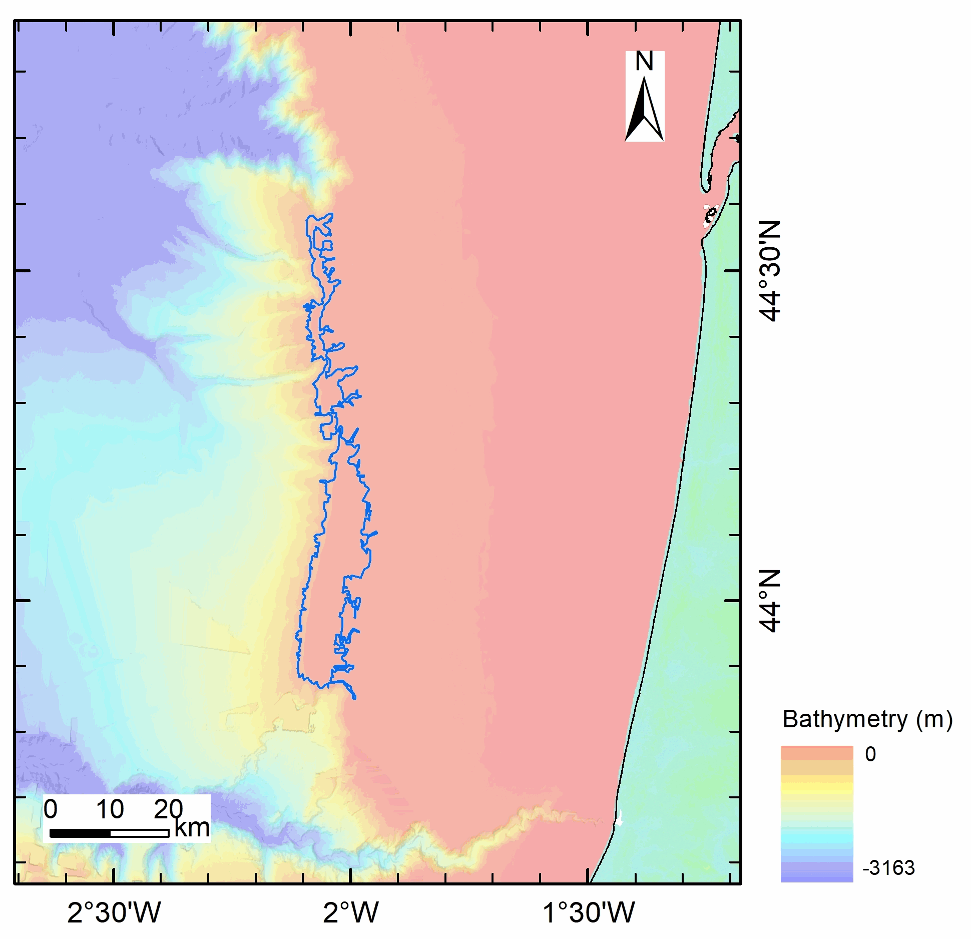
The present database is composed of a polygon shape file (.shp) dedicated to GIS applications. This seafloor surface represents the area within which (sub-)outcropping methane derived authigenic carbonates were identified based on ship-borne multibeam bathymetry and seafloor backscatter data; as displayed in Figs. 4 and S1a of Dupré et al. 2020 (Dupré S, Loubrieu B, Pierre C, Scalabrin C, Guérin C, Ehrhold A, Ogor A, Gautier E, Ruffine L, Biville R, Saout J, Breton C, Floodpage J, Lescanne M (2020) The Aquitaine Shelf Edge (Bay of Biscay): A Primary Outlet for Microbial Methane Release. Geophysical Research Letters 47 (7):e2019GL084561. doi:10.1029/2019gl084561). The presence of (sub-)outcropping methane-derived authigenic carbonates at the seafloor was confirmed by remotely-operated-vehicle dives during the GAZCOGNE2 marine expedition. The acoustic data were acquired in 2013 on board the R/V Le Suroît during the GAZCOGNE1 expedition with two ship-borne multibeam echosounders, the Kongsberg EM302 and EM2040, with transmission frequency of 30 and 200 kHz, respectively. Details on multibeam data acquisition, processing and interpretation of sub-outcropping methane-derived authigenic carbonate structures are presented in Dupré et al 2020 (including a Supporting Information section). Cited from Dupré et al 2020: “The carbonates are exclusively located along the shelf edge with the majority (98%) between 140 and 220 m water depths. The (sub-)outcropping carbonates are spread over a 375 km2 area that extends over a distance of 80 km between the Cap Ferret and Capbreton canyons. The western spatial limit of the methane-derived authigenic carbonates coincides with the shelf break.”
-
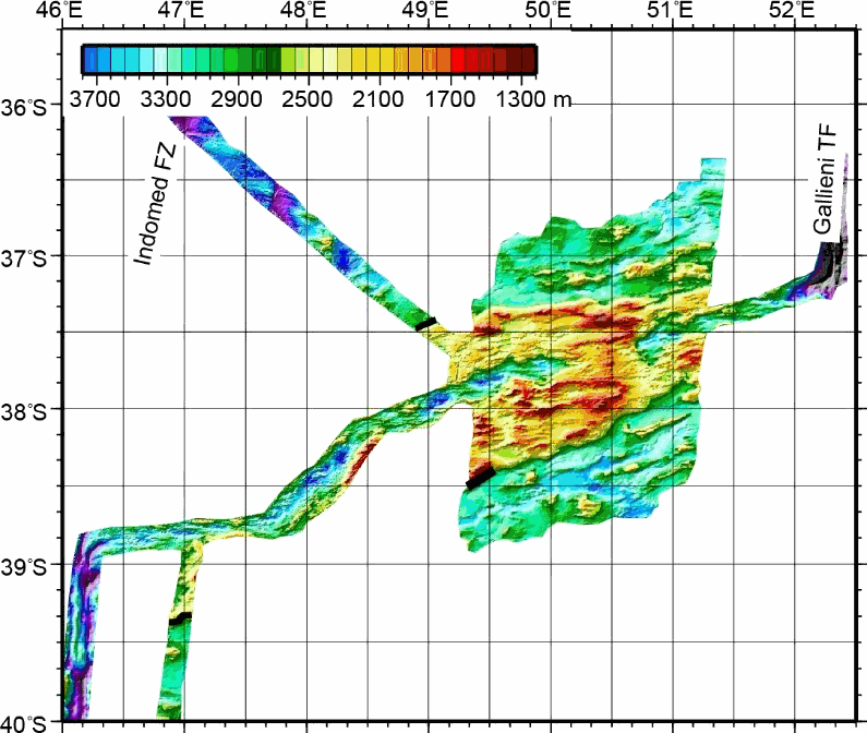
This grid was obtained by merging multibeam bathymetric data from several french cruises along the Southwest Indian Ridge from the Indomed to the Gallieni Transform Faults. The spatial resolution is about 150 m. This dataset was used in several scientific papers.
-
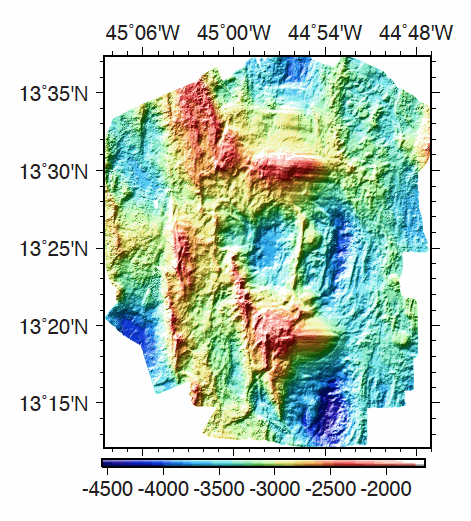
Multibeam bathymetry data, gridded at 40m, acquired around the 13°20'N and 13°30'N oceanic detachments along the Mid-Atlantic Ridge. Bathymetric data was acquired by the PourQUoi Pas? multibeam system (RESON 7150). Data is provided as a grid in GRD format (GMT NETCDF). grdinfo of the file: - ODEMAR_Shipboard_Bathymetry_40m.grd: Title: Bathy_40m.grd - ODEMAR_Shipboard_Bathymetry_40m.grd: Command: File written by MATLAB function grdwrite2.m - ODEMAR_Shipboard_Bathymetry_40m.grd: Remark: Created 22-Nov-2014 16:35:13 - ODEMAR_Shipboard_Bathymetry_40m.grd: Gridline node registration used [Cartesian grid] - ODEMAR_Shipboard_Bathymetry_40m.grd: Grid file format: nf = GMT netCDF format (32-bit float), COARDS, CF-1.5 - ODEMAR_Shipboard_Bathymetry_40m.grd: x_min: -45.14293893 x_max: -44.77177893 x_inc: 0.00036 name: x nx: 1032 - ODEMAR_Shipboard_Bathymetry_40m.grd: y_min: 13.20017553 y_max: 13.62389553 y_inc: 0.00036 name: y ny: 1178 - ODEMAR_Shipboard_Bathymetry_40m.grd: z_min: -4498.29248047 z_max: -1935.33117676 name: z - ODEMAR_Shipboard_Bathymetry_40m.grd: scale_factor: 1 add_offset: 0 - ODEMAR_Shipboard_Bathymetry_40m.grd: format: classic
-

The coastal topobathymetric DEM of Ré Island's surroundings, with a resolution of 0.00005° (~5 meters), was created by Shom as part of the HOMONIM-3 project. It covers the coast of the municipalities of Ars-en-Ré and Saint-Clément-des-Baleines, extending offshore to a depth of about 20 meters, to the west of the Phare des Baleines lighthouse. This DEM is designed for use in hydrodynamic models to enhance the modeling of coastal processes, particularly forecasting submersion risk. The product complements the coastal topobathymetric DEM of the Pertuis-Charentais, with a resolution of 0.0002° (~20 meters), and the bathymetric DEM of the Atlantic coast, with a resolution of 0.001° (~100 meters). It is available in the vertical reference of the Lowest Astronomical Tide (LAT) or the Mean Sea Level (MSL).
-

The coastal topo-bathymetric DEM of Tahiti with a resolution of 0.0002° (~ 20 m) was produced by the Shom for Météo-France (Inter-regional Direction in French Polynesia). This DEM covers the Tahiti lagoons down to the 100 m isobath, in order to meet the need for modeling marine submersions in French Polynesia. It complements the bathymetric DEM of Tahiti and Moorea, with a resolution of 0.001° (~ 100 m). This product is available at different vertical references, either the lowest astronomical tide (LAT) or the mean sea level (MSL).