 Metadata catalogue
Atlantic ocean
Type of resources
Available actions
Topics
INSPIRE themes
Keywords
Contact for the resource
Provided by
Years
Formats
Representation types
Update frequencies
Scale
-
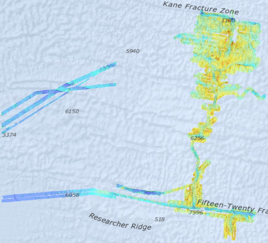
Bathymetry - Mid-Atlantic Ridge from N 13°30 to N 24° (synthesis, 2021). Compilation of Ifremer multibeam data along the Mid-Atlantic Ridge. Grid resolution 1/16 arc minute. Bibliography: Viellefon Priscille (2020). Cartographie – Compilation et analyses numériques de données bathymétriques sur la dorsale Atlantique Nord centrale. Rapport de stage technique. https://archimer.ifremer.fr/doc/00679/79153/ Ifremer multibeam database : cruises from 1991 to 2018. Data sets acquired onboard Ifremer research vessels are processed according to a common flow : - Time and acquisition lines selection - Removing outliers by automatic filtering - Manual cleaning and residual artefact removing - Producing a digital terrain model (DTM). Depth layer is calculated as the average of soundings in each pixel. The grid resolution is 1/16 of arcminute. All DTMs are merged into a unique file. Cruise list : Fara-Seadma1, 1991, RV L’Atalante, https://doi.org/10.17600/91004411 Fara Sigma, 1991, RV L’Atalante, https://doi.org/10.17600/91004311 Faranaut/15N, 1992, RV L’Atalante, https://doi.org/10.17600/92000311 Dormasis, 1992, RV L’Atalante, https://doi.org/10.17600/92000411 Sudacores, 1998, RV L’Atalante, https://doi.org/10.17600/98010080 Bicose, 2014, RV Pourquoi Pas ?, https://doi.org/10.17600/14000100 Leve-SMF, 2016, RV Pourquoi Pas ?, https://doi.org/10.17600/16010800 Hermine, 2017, RV Pourquoi Pas ?, https://doi.org/10.17600/17000200 Transect, 2018, RV L’Atalante, https://doi.org/10.17600/18000513
-

Bathymetry - Mid-Atlantic Ridge from N 24°to N 36° (synthesis, 2021). Compilation of Ifremer multibeam data along the Mid-Atlantic Ridge. Grid resolution 1/16 arc minute. Bibliography: Viellefon Priscille (2020). Cartographie – Compilation et analyses numériques de données bathymétriques sur la dorsale Atlantique Nord centrale. Rapport de stage technique. https://archimer.ifremer.fr/doc/00679/79153/ Ifremer multibeam database : cruises from 1991 to 2018 Data sets acquired onboard Ifremer research vessels are processed according to a common flow : - Time and acquisition lines selection - Removing outliers by automatic filtering - Manual cleaning and residual artefact removing - Producing a digital terrain model (DTM). Depth layer is calculated as the average of soundings in each pixel. The grid resolution is 1/16 of arcminute. All DTMs are merged into a unique file. Cruise list : Sara, 1990, RV Jean Charcot, https://doi.org/10.17600/90000411 Fara-Seadma1, 1991, RV L’Atalante, https://doi.org/10.17600/91004411 Fara Sigma, 1991, RV L’Atalante, https://doi.org/10.17600/91004311 Faranaut/15N, 1992, RV L’Atalante, https://doi.org/10.17600/92000311 Dormasis, 1992, RV L’Atalante, https://doi.org/10.17600/92000411 Sudacores, 1998, RV L’Atalante, https://doi.org/10.17600/98010080 Bicose, 2014, RV Pourquoi Pas ?, https://doi.org/10.17600/14000100 Leve-SMF, 2016, RV Pourquoi Pas ?, https://doi.org/10.17600/16010800 Hermine, 2017, RV Pourquoi Pas ?, https://doi.org/10.17600/17000200 Transect, 2018, RV L’Atalante, https://doi.org/10.17600/18000513