 Metadata catalogue
Atlantic Ocean
Type of resources
Available actions
Topics
INSPIRE themes
Keywords
Contact for the resource
Provided by
Years
Formats
Representation types
Update frequencies
Scale
Resolution
-
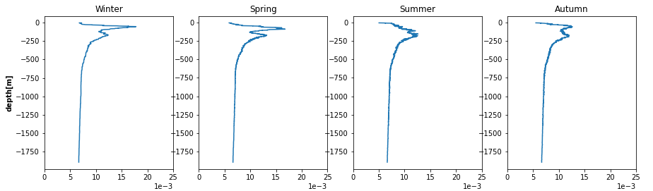
The SDC_GLO_CLIM_N2 product contains seasonally averaged Brunt-Vaisala squared frequency profiles using the density profiles computed in SeadataCloud Global Ocean Climatology - Density Climatology. The Density Climatology product uses the Profiling Floats (PFL) data from World Ocean database 18 for the time period 2003 to 2017 with a Nonlinear Quality procedure applied on it. Computed BVF profiles are averaged seasonally into 5x5 degree boxes for Atlantic and Pacific Oceans. For data access, please register at http://www.marine-id.org/.
-
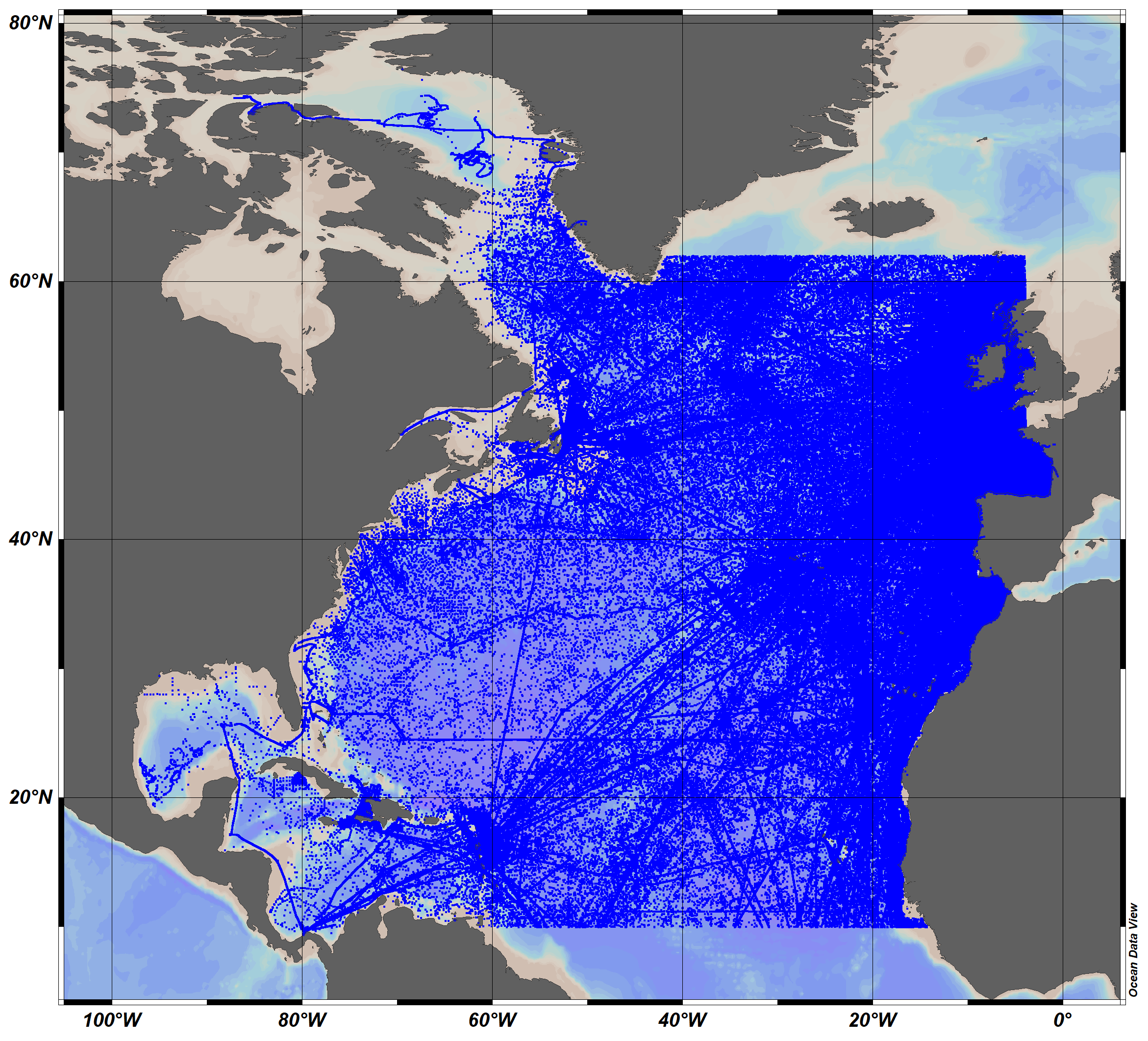
The SeaDataCloud TS historical data collection V2 for the North Atlantic Ocean, includes open access in situ data on temperature and salinity of water column in the North Atlantic Ocean from 10°N to 62°N, including the Labrador Sea, The data were retrieved from the SeaDataNet infrastructure at summer 2019. The dataset format is Ocean Data View (ODV - http://odv.awi.de/) binary collection. The quality control of the data has been performed with the help of ODV software. Data Quality Flags have been revised and set up using the elaborated by SeaDataNet2 project QC procedures in conjunction with the visual expert check. The final number of the Temperature and Salinity profiles (stations) in the collection is 10119755. For data access please register at http://www.marine-id.org/.
-
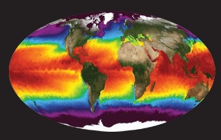
NASA's Physical Oceanography Distributed Active Archive Center (PO.DAAC) is located at NASA's Jet Propulsion Laboratory in Pasadena, California. PO.DAAC manages and provides tools and services for NASA's oceanographic and hydrologic data (satellite, airborne, and in-situ) to enable a greater understanding of the physical processes and conditions of the global ocean. Measurements include gravity, ocean winds, sea surface temperature, ocean surface topography, sea surface salinity, and circulation. The data support a wide range of applications including climate research, weather prediction, resource management, policy, and the stewardship of ocean data resources.
-
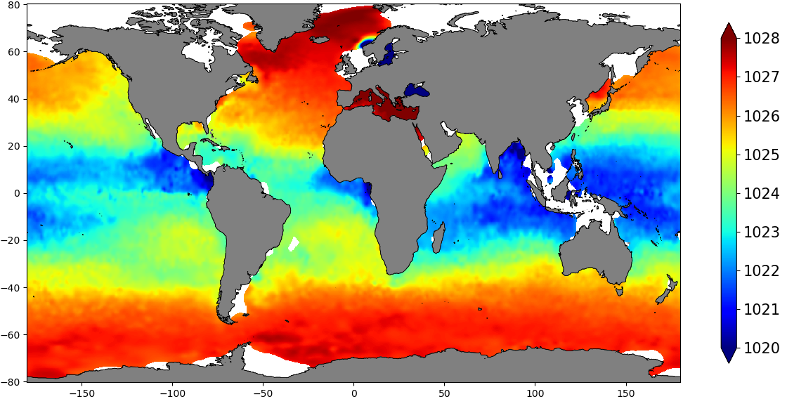
The SDC_GLO_CLIM_Dens product contains global monthly climatological estimates of in situ density using Temperature and Salinity from profiling floats contained in the World Ocean Data 18 (WOD18) database. The profiles were first quality controlled with a Nonlinear Quality control procedure. The climatology considers observations from surface to 2000 m for the time period 2003-2017. Density profiles are computed using UNESCO 1983 (EOS 80) equation from in situ temperature, salinity and pressure measurements by the PFL. Only profiles with both T,S values were used. The gridded fields are computed using DIVAnd (Data Interpolating Variational Analysis) version 2.3.1.
-
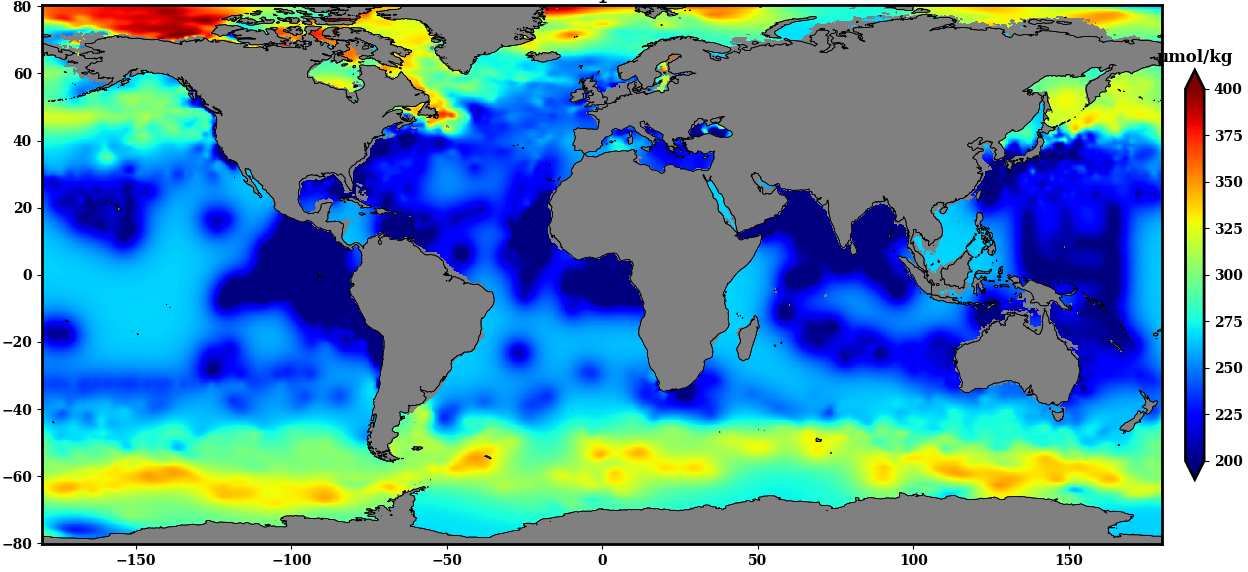
The SDC_GLO_CLIM_O2_AOU product contains two different monthly climatology for dissolved Oxygen and Apparent Oxygen Utilization, SDC_GLO_CLIM_O2 and SDC_GLO_CLIM_AOU respectively from the World Ocean Data (WOD) database. Only basic quality control flags from the WOD are used. The first climatology, SDC_GLO_CLIM_O2, considers Dissolved Oxygen profiles casted together with temperature and salinity from CTD, Profiling Floats (PFL) and Ocean Station Data (OSD) for time duration 2003 to 2017. The second climatology, SDC_GLO_CLIM_AOU, apparent Oxygen utilization, is computed as a difference of dissolved oxygen and saturation O2 profiles. The gridded fields are computed using DIVAnd (Data Interpolating Variational Analysis) version 2.3.1.
-
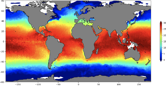
The SDC_GLO_CLIM_TS_V2 product is an improved version of SDC_GLO_CLIM_TS_V1 and contains two different monthly climatologies for temperature and salinity from the World Ocean Data 2018 (WOD-18) database. Along with the basic quality control flags from the WOD-18, an additional quality Control named Nonlinear Quality Control (NQC) is applied. The first climatology, V2_1, considers temperature and salinity profiles from Conductivity Depth Temperature (CTD), Ocean station data (OSD) and Moored buoy data (MRB) along with Profiling Floats (PFL) from 1900 to 2017. The second climatology, V2_2, utilizes only PFL data from 2003 to 2017. V2_1 considers 44 layers from surface to 6000 m while V2_2 only 34 from 0 to 2000 m. The gridded fields are computed using DIVAnd (Data Interpolating Variational Analysis) version 2.3.1. For data access, please register at http://www.marine-id.org/.
-

3-D habitat suitability maps (HSM) or probability of occurrence maps, built using Shape-Constrained Generalized Additive Models (SC-GAMs) for the 30 main commercial species of the Atlantic region. Predictor variables for each species were selected from: sea water temperature, salinity, nitrate, net primary productivity, distance to seafloor, distance to coast, and relative position to mixed layer depth. Each species HSM contains 47 maps, one per depth level from 0 to 1000 m. Probability values of each map range from 0 (unsuitable habitat) to 1 (optimal habitat). For depth levels below the 0.99 quantile of the depth values found on the species occurrence data, NA values were assigned. Maps have been masked to species native range regions. See Valle et al. (2024) in Ecological Modelling 490:110632 (https://doi.org/10.1016/j.ecolmodel.2024.110632 ), for more details.
-
In many places, marine phosphorites are accompanied by Fe-Mn crust mineralisations on the seafloor of continental shelves and slopes along the western continental margins of the Atlantic Ocean. They tend to occur in waters of medium depth. Some thick Fe-Mn crusts also contain carbonate fluorapatite, which was incorporated into the crusts during specific periods prior to middle Miocene during main Cenozoic episodes of phosphatization. These deposits are related to strong upwelling along the continental margins and seamounts. Marine phosphorites are known to concentrate rare earth elements and yttrium (REY) during early diagenetic formation. Although there are several references to ferromanganese crusts and their association with phosphorites in the literature, the genetic models for explaining their relationship and metal concentration are still poorly understood.
-
"Exploration in the Atlantic, Mediterranean, Baltic and Black Sea" refers to marine exploration of mineral accumulations, deposits, resources and reserves on the Atlantic. Mediterranean, Baltic and Black Sea seabed. The target for MINDeSEA WP 7 is (i) to create a new dataset on the distribution of the explored areas for submarine mineral resources in Europe; (ii) to propose recommendations for new unexplored areas; and (iii) to recommend pilot areas with high potential of discovering new submarine mineral resource mineral accumulations
-
Marine ferromanganese crust deposits are potential mineral resources that contain base metals and strategic and critical elements such as cooper (Cu), cobalt (Co), vanadium (V), nickel (Ni), titanium (Ti), platinum group elements (PGEs) or rare earth elements (REEs). Traditionally, marine precipitates are defined as: a) purely hydrogenetic when all constituents are derived from cold seawater, (b) diagenetic, when all constituents are derived from cold sediment pore water; and (c) hydrothermal when precipitation occurs in the vicinity of hydrothermal vent sites from fluids with temperatures higher than ambient bottom waters. Hydrogenetic Fe-Mn crusts occur throughout the global ocean on seamounts, ridges and plateaus, where currents have kept the rocks free of sediment for millions of years. Some ferromanganese (Fe-Mn) crusts exhibit a mixed origin, primarily either hydrothermal-hydrogenetic or hydrogenetic-diagenetic (Hein et al., 2000; 2003; 2013; Muiños et al. 2013; Bau et al., 2014; Marino et al., 2017). In many places, marine phosphorites are accompanied by Fe-Mn crust mineralisations on the seafloor of continental shelves and slopes along the western continental margins of the Atlantic Ocean. Some thick Fe-Mn crusts also contain carbonate fluorapatite, which was incorporated into the crusts during specific periods prior to middle Miocene during main Cenozoic episodes of phosphatization. These deposits are related to strong upwelling along the continental margins and seamounts. Marine phosphorites are known to concentrate rare earth elements and yttrium (REY) during early diagenetic formation (Hein et al., 1993; 2016; González et al., 2016). Although there are several references to ferromanganese crusts and their association with phosphorites in the literature, the genetic models for explaining their relationship and metal concentration are still poorly understood.