 Metadata catalogue
Archaeology
Type of resources
Available actions
Topics
INSPIRE themes
Keywords
Contact for the resource
Provided by
Years
Formats
Representation types
Update frequencies
Scale
Resolution
-
HERs (Historic Environment Records) developed out of SMRs (Sites and Monuments Records). SMRs were established from the 1960s onwards in response to the loss of the archaeological resource through urban and rural development. From their original remit of recording archaeological sites, they have been developed to encompass a wide range of information about the historic environment which has been reflected in the change of name from SMR to HER. Today they provide a unique information resource, forming the basis for sustainable conservation and playing an important role in informing public understanding and enjoyment of the local historic environment. The historic environment includes all aspects of our surroundings that have been built, formed or influenced by human activities from earliest to most recent times. A Historic Environment Record stores and provides access to systematically organised information about these surroundings in a given area. It is maintained and updated for public benefit in accordance with national and international standards and guidance. An HER makes information accessible to all in order to: - advance knowledge and understanding of the historic environment; - inform its care and conservation; - inform public policies and decision-making on land-use planning and management; - contribute to environmental improvement and economic regeneration; - contribute to education and social inclusion; - encourage participation in the exploration, appreciation and enjoyment of the historic environment. Local authorities and most National Park authorities maintain records of the archaeological, built and natural environment. However, many services group together to form archaeological services to collate their standardised records. Specialist staff are employed to curate these records and also to provide specialist advice for land-use planning and public information services. This dataset has two distinct data layers: - Historic Environment Sites (including Known Site Extents and Areas of Archaeological Interest) - a polygon dataset - Historic Environment Events (also known as interventions) - a polygon dataset. Where only points or lines have been provided these have been buffered by 10m to create representative polygons.
-

Defining Scotland’s Places (DSP) aims to define the known extent of the archaeological sites and monuments in the National Record of the Historic Environment at Historic Environment Scotland, John Sinclair House, Edinburgh. The polygons created through Defining Scotland's Places do not carry ANY legal status. For instance they do not represent the legal extent of a Scheduled Monument or Listed Building.
-
The Properties in Care dataset comprises information on properties in the care of Historic Environment Scotland on behalf of Scottish Ministers and others. The properties in care estate is a collection of monuments, which define significant aspects of Scotland's history, brought into care for their long term preservation and public benefit through the Ancient Monuments and Archaeological Areas Act 1979. The dataset identifies the approximate location of properties and sites.
-
Scheduled monuments are nationally important monuments and sites. The aim of scheduling is to preserve sites and monuments as far as possible in the form in which they have come down to us today. They are legally protected through the Ancient Monuments and Archaeological Areas Act 1979. National importance takes account of a wide range of factors, including artistic, archaeological, architectural, historic, traditional, aesthetic, scientific and social. Guidance and criteria to assess national importance of monuments is set out by Scottish Ministers in The Scottish Historic Environment Policy. This data allows you to identify the approximate position, size and extent of scheduled monuments in Scotland.
-

Historic Marine Protected Areas ‘Historic MPAs’ are designated under Section 67 of the Marine Scotland Act 2010 to protect marine historic assets (e.g historic shipwrecks) of national importance within Scottish territorial waters. The Scottish Government is committed to clean, healthy, safe, productive, biologically diverse marine and coastal environments, managed to meet the long-term needs of people and nature. This includes protecting and, where appropriate, enhancing our most important historic wrecks and other marine heritage sites in such a way that they can be valued and understood. One way Scottish Ministers can achieve this is by designating nationally important marine historic assets in Scottish territorial waters as Historic Marine Protected Areas under the Marine (Scotland) Act 2010. The data shows the boundaries of all Historic Marine Protected Areas in Scotland. You should refer to the Historic Marine Protected Area site documentation for exact locations of individual boundary points and supplementary information.
-
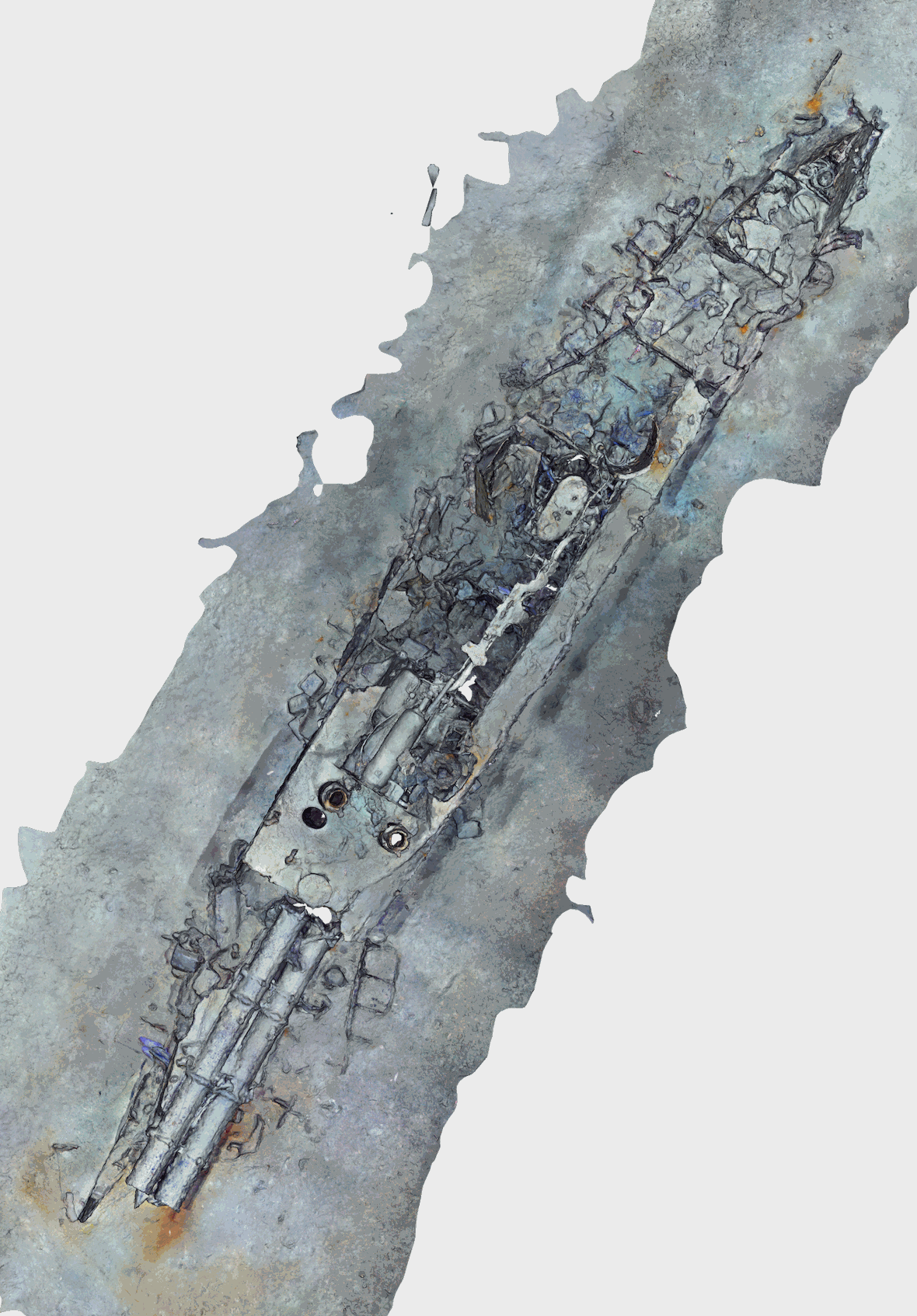
Abstract Torpedo boat wreck off-the southern French Mediterranean coast (43.124°N;6.523°E), at a water depth of ~476 m. This battle ship sank in 1903 (https://www.postenavalemilitaire.com/t11913-torpilleur-059-1881-1903) and the wreck is is ~20 m long and 3 m wide, raising ~2 m above the surrounding seafloor. This shipwreck was surveyed using the HROV Arianne in 2016, deployed from N/O L’Europe, and equipped with a vertical electronic still camera. Two datasets are provided. First, the survey imagery, that consists of 442 images (jpeg format) and an associated navigation file in dim2 format (torpdo_boat_imagery). Second, a 3D textured model of the site (obj format), together with the a kml file for georeferencing, and a geotiff orthomosaic (torpedo_boat_model). This dataset is one of several sets released with a paper by Arnaubec et al. (submitted to Computer and Geosciences) presenting the Matisse image processing software, and the 3DMetrics Visualization and analysis software (ref Github to come). Arnaubec, A., J. Escartín, J. Opderbecke, M. Matabos, N. Gracias, submitted, Underwater 3D terrain reconstruction from video or still imagery: Processing and exploitation software (MATISSE \& 3DMETRICS), Computers and Geosciences