 Metadata catalogue
Analysis data
Type of resources
Available actions
Topics
Keywords
Contact for the resource
Provided by
Years
Formats
-
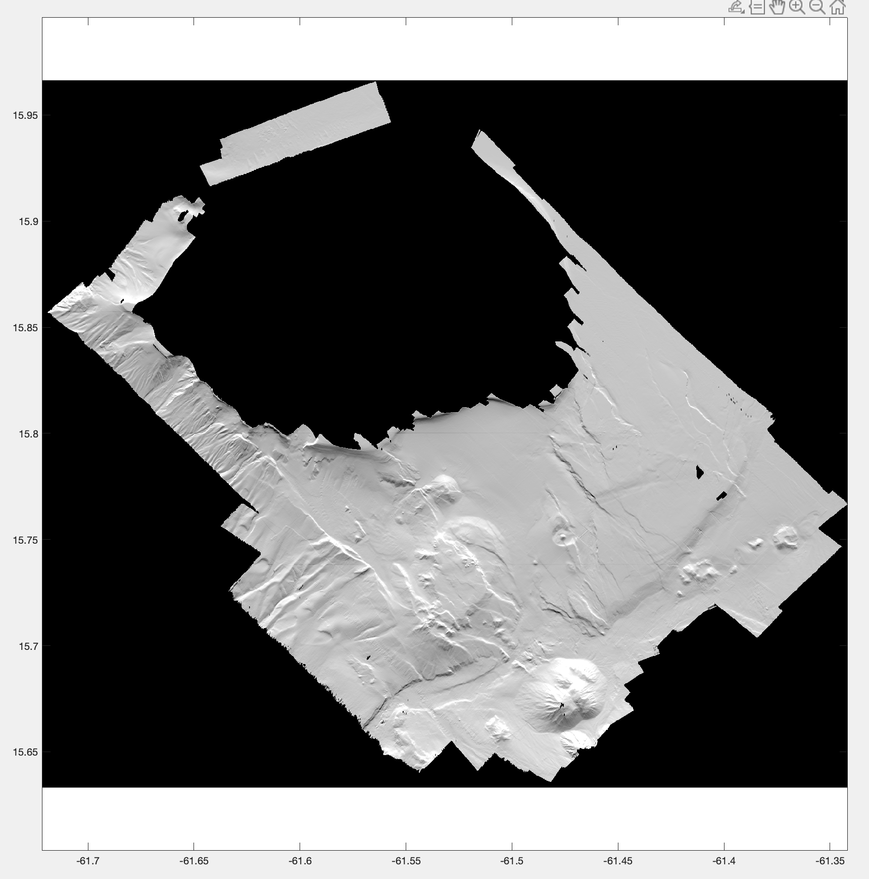
Bathymetry grid, with a pixel resolution of 25 m, from bathymetry data acquired during the 2010 Bathysaintes cruise (https://doi.org/10.17600/10030020). Data were controlled and processed with the Ifremer Caraibes software.
-
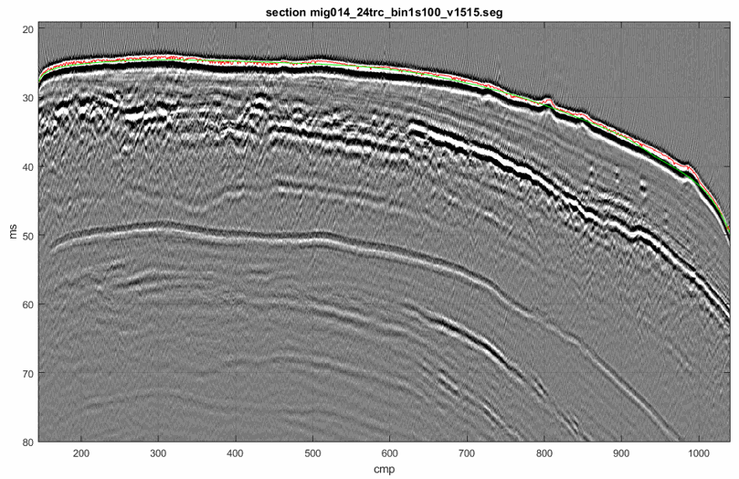
Seismic profile ST5-014 was acquired in May 2015 during the STEP 2015 cruise (DOI:10.17600/15006100) on the continental shelf offshore Nice Airport (SE France). The source was a 1200 J Sparker from Geo Marine Survey with electrical pulse on a 400 tip electrode. The seismic data were recorded on a Geo-sense 48-channel streamer of 230 m long with a trace spacing of 3.125 m which was towed at a depth of 0.6 m. One Automatic Identification System was deployed on the seismic source and two others on the head and tail of the streamer to ensure positioning with meter accuracy. The pre-processing of the seismic data included common midpoint binning, spherical divergence correction, 125-2500 Hz bandpass filtering, normal moveout correction and signature deconvolution. To preserve the high frequency content of the source only the first 24 traces were stacked (i.e. maximum offset of 80 m). This provided seismic data with a frequency range of 175 to 850 Hz. Detailed Root Mean Square velocity analyses were performed on super gathers every 1 m. After the picking of velocities on semblance panels, interval velocities were computed using the Dix equation. Stack and post-stack time migration were then applied using this velocity field. The time-migrated seismic data were converted to standard SEG-Y rev1 format (https://seg.org/Portals/0/SEG/News%20and%20Resources/Technical%20Standards/seg_y_rev1.pdf) with values written using “big-endian” byte ordering and IEEE floating-point. Seismic coordinates in trace headers are in WGS84 format and +DDDMMSS.ss unit (with a scale factor of -100).
-
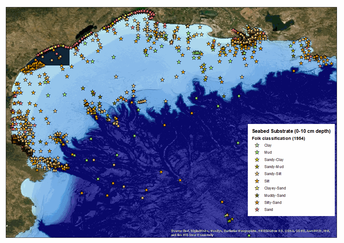
The Gulf of Lion is located in the north-western part of the western Mediterranean basin, between Cap Creus (Pyrenean chain) in the south-west (Spanish border) and Cap Sicié (near Toulon) in the north-east. It is characterised by a wide crescent-shaped continental shelf, 200 km long. The continental shelf reaches a maximum width of 70 km off Cap d'Agde and narrows towards the east and west as it approaches the Provencal and Pyrenean-Catalan margins. It extends between 0 and 120 to 180 m deep and has an average inclination of 0.5° (reaching up to 5° at the deltaic slopes). Numerous canyons notch the edge of the platform. The river Rhône is the main source of terrigenous inflows from the Gulf of Lion, up to about 90% (Bourrin et al., 2006), and the Rhône prodelta is an area of significant accumulation of fluvial solid inflows. The current morphology of the Gulf of Lion is strongly linked to current river flows, but also to the legacy of past environmental conditions from the last low sea level 20,000 years ago. In 2012, Ifremer had planned to produce a map of the seabed substrate in this sector based on a compilation of acoustic and sedimentary data. Indeed, the Gulf of Lion has been the subject of oceanographic studies and campaigns for many years. An inventory of the campaigns at sea had been carried out thanks to the SISMER (Scientific Information Systems for the Sea) community databases and Infoterre internet portal managed by the BRGM (the French Geological Survey). These databases had enabled the referencing of laboratories involved campaigns and samples collection in the Gulf of Lion since 1991: - Ifremer, - Shom - University of Perpignan Via Domitia (Cefrem), - Aix-Marseille University (CEREGE ; MIO Mediterranean Institute of Oceanology), - CNRS (French National Centre for Scientific Research) - Sorbonne University, - IRSN (Institute for Radiological Protection and Nuclear Safety), - the French Office for Biodiversity (OFB) (previously Marine Protected Areas Agency), - the Conseil départmental de l’Hérault in the framework of the European projects Beachmed, - the Rhone-Mediterranean-Corsica Water Agency. Partnership agreements for the provision of samples and data had been signed with these research laboratories or local authorities. If the production of a map had not been successful, a total of 2 110 samples (see xls-sheet1 file) had been recorded in the Gulf of Lion. The sampling tools used were diverse and the techniques used to analyse the samples also varied from one campaign to another. To validate the results of existing analyses, we compared the samples preparation and analysis protocols. When we had no information on these protocols, the granulometric analysis was redone when the sample still existed, or the result was compared with the valid analysis of a geographically close sample. In the absence of these information, the analyses were rejected. The analyses provided by IRSN (150 samples) and CEREGE (321 samples) were acquired using a sample preparation and analysis protocol similar to that adopted for our study and were validated. Out of 144 samples taken by Ifremer, the analyses were redone in order to obtain homogeneity with the sample preparation and analysis protocol of CEREGE and IRSN. Data from the University of Perpignan, resulting from the work of Jean-Claude Aloisi (between 1970 and 1986) which led to the first sediment distribution map of the Gulf of Lion dating from 1986, were analysed by sieving at 40 µm, determining the pelite/ sand limit at this size. Other classifications (Folk, ISO 13 320, Uden and Wentworth, ...) determine a pelite/sand limit at 63µm. It is therefore difficult to compare these data without recalibrating all the data of the 40µm laser granulometers. In the end, in order to guarantee an intercomparison of the analyses, only 1659 samples were validated after harmonisation and standardisation and all the data from the so-called "Aloisi" campaign had to be discarded (see xls-sheet2 file). The composition of the surficial sedimentary cover (of 10 cm thick; which corresponds to the capacity of penetration into the sediments of the acoustic waves emitted by the multibeam echosounders) of the Gulf of Lion shelf is relatively heterogeneous. It is strongly linked to current river inputs, but also to inherited environmental conditions from the last low sea level 20,000 years ago. At present, coarse river inflows feed the sandy coastline near the mouths, while fine inflows are transported by currents and waves over the entire platform. Different sedimentary facies appear from the coast towards the slope, parallel to the shoreline: - The inner shelf is subject to the action of swell and storms (Guizien, 2009) that cause sediment to resuspend. Richly sandy outside of the areas influenced by rivers, this area is relatively poor in clay (from 2 to 16%); clay deposits cannot be made under these conditions. It runs along the coastline, up to 30 m. It gets thinner, until it disappears, opposite the mouth of the Rhône (Gulf of Fos) in its eastern part, and opposite Cap Creus in its western part. - The median shelf, richer in clay (from 16 to 26%) located between 30 and 100 m depth on average, is known as the "median mudflat". The slope break, observed between 40 and 50 m, corresponds to the transition zone between the silto-pelitic deposits and the offshore sediments (clay phase). The particle diameter gradient is quite marked, depending on the bathymetry: 50 to 80 µm between 30 and 50 m and 10 to 15 µm from the 50 m isobath. This tendency is rather marked near the mouths of rivers, particularly the Petit Rhône, the Orb and the Hérault. - The outer shelf (located at the limit between the continental shelf and the slope) presents a sandy to sandy-muddy mixture (60% sand with a median diameter of between 80 and 100 µm and up to 500 µm). These so-called "relict" sands are derived from coastal deposits dated of Ante-Holocene age, when the continental shelf was nearly emerging. At the mouth of the Grand Rhône, the most important source of particles in the Gulf of Lion, the internal plateau does not have the same appearance, as it is the site of significant sedimentation concentrated in the form of a prodelta. At the level of this prodelta, the distribution of sediments shows a significant granulometric gradient near the mouth, with a concentration of coarse sands (>450µm) at the top (mouth bar), followed by a rapid predominance of fine sediments from the 20 m isobath, which in the area corresponds to the depth of closure of the swells. The predominance of the fine fraction occurs much faster than on the rest of the plateau. The average slope of the prodeltaic zone has been evaluated at 5° and the 100 m isobath is about ten kilometres from the mouth of the Rhône, compared with more than 50 km for most of the French Mediterranean coast of the Gulf of Lion. The Rhone's fluvial inflows are also subject to a transport dynamic towards the west and south-west, which leads to a circulation of particles over the entire continental shelf of the Gulf of Lion and their potential transport to deeper area through the heads of submarine canyons (Durrieu de Madron et al., 1990). The hydro-sedimentary functioning of the Gulf of Lion is thus characterised as follows: (i) a forced sedimentation of fine particles in the prodeltas, (ii) an advective transfer of the fine mineral from the continental sources and prodeltas to the sediments of the circalittoral mudflat, and (iii) the export of homogeneous material from the continental shelf, through the outfalls of the south-western shelf. Within this particulate dynamics, the prodelta plays an important role. By its characteristics as an area of decantation and regulation of continent/sea exchanges, the prodelta is apparented to the estuarine turbidity maximum of the macrotidal seas. Finally, as the surface sediments analysed in the Gulf of Lion are mainly composed of fine sediments, the authors believe that the simplified Flemming classification best suited to this type of environment and should be preferred for mapping the distribution of sedimentary facies in the study area. References : Guizien (2009) - Spatial variability of wave conditions in the Gulf of Lions (NW Mediterranean sea). Life and Env. 59 (3-4):1-10. Durrieu de Madron et al. (1990) - Hydrographic structure and nepheloid spatial distribution in the Gulf of Lions continental margin.Continental Shelf Research 10(9-11):915-929. DOI: 10.1016/0278-4343(90)90067-V
-
2D seismic lines from Haiti-sis 1&2 cruises. Processed and interpreted lines.
-
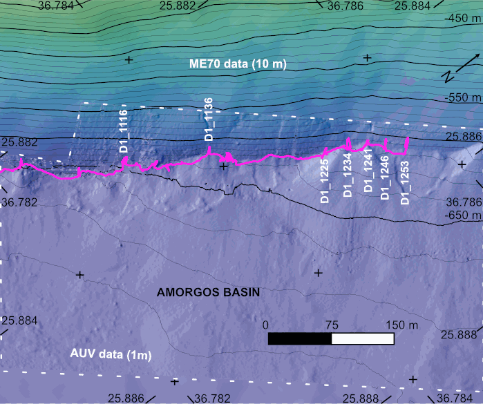
The AMORGOS-23 cruise (https://doi.org/10.17600/18003211) was conducted onboard R/V Europe from April 26th 2023 to May 9th 2023. Using HROV Ariane equipped with 4K cameras, we surveyed the main active faults between Amorgos and Anafi islands in order to identify and quantify recent deformation of the seafloor linked to the 1956 Amorgos earthquake. During dive 244-1, we surveyed the steepest scarp of the Amorgos fault, along its central segment. We provide here seven scaled Digital Outcrop Models (in .obj format) calculated from the HROV videos with MATISSE 3D software. There location (model origin) is also provided in a table, together with information about the portions of the videos used to produce the models. Due to incomplete navigation data, the models are not properly oriented.
-
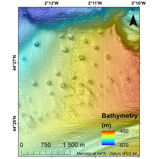
Pockmarks are defined as depressions on the seabed and are usually formed by fluid expulsions. Recently discovered, pockmarks along the Aquitaine slope within the French EEZ, were manually mapped although two semi-automated methods were tested without convincing results. In order to potentially highlight different groups and possibly discriminate the nature of the fluids involved in their formation and evolution, a morphological study was conducted, mainly based on multibeam data and in particular bathymetry from the marine expedition GAZCOGNE1, 2013. Bathymetry and seafloor backscatter data, covering more than 3200 km², were acquired with the Kongsberg EM302 ship-borne multibeam echosounder of the R/V Le Suroît at a speed of ~8 knots, operated at a frequency of 30 kHz and calibrated with ©Sippican shots. Precision of seafloor backscatter amplitude is +/- 1 dB. Multibeam data, processed using Caraibes (©IFREMER), were gridded at 15x15 m and down to 10x10 m cells, for bathymetry and seafloor backscatter, respectively. The present table includes 11 morphological attributes extracted from a Geographical Information System project (Mercator 44°N conserved latitude in WGS84 Datum) and additional parameters related to seafloor backscatter amplitudes. Pockmark occurrence with regards to the different morphological domains is derived from a morphological analysis manually performed and based on GAZCOGNE1 and BOBGEO2 bathymetric datasets. The pockmark area and its perimeter were calculated with the “Calculate Geometry” tool of Arcmap 10.2 (©ESRI) (https://desktop.arcgis.com/en/arcmap/10.3/manage-data/tables/calculating-area-length-and-other-geometric-properties.htm). A first method to calculate pockmark internal depth developed by Gafeira et al. was tested (Gafeira J, Long D, Diaz-Doce D (2012) Semi-automated characterisation of seabed pockmarks in the central North Sea. Near Surface Geophysics 10 (4):303-315, doi:10.3997/1873-0604.2012018). This method is based on the “Fill” function from the Hydrology toolset in Spatial Analyst Toolbox Arcmap 10.2 (©ESRI), (https://pro.arcgis.com/en/pro-app/tool-reference/spatial-analyst/fill.htm) which fills the closed depressions. The difference between filled bathymetry and initial bathymetry produces a raster grid only highlighting filled depressions. Thus, only the maximum filling values which correspond to the internal depths at the apex of the pockmark were extracted. For the second method, the internal pockmark depth was calculated with the difference between minimum and maximum bathymetry within the pockmark. Latitude and longitude of the pockmark centroid, minor and major axis lengths and major axis direction of the pockmarks were calculated inside each depression with the “Zonal Geometry as Table” tool from Spatial Analyst Toolbox in ArcGIS 10.2 (©ESRI) (https://pro.arcgis.com/en/pro-app/tool-reference/spatial-analyst/zonal-statistics.htm). Pockmark elongation was calculated as the ratio between the major and minor axis length. Cell count is the number of cells used inside each pockmark to calculate statistics (https://pro.arcgis.com/en/pro-app/tool-reference/spatial-analyst/zonal-geometry.htm). Cell count and minimum, maximum and mean bathymetry, slope and seafloor backscatter values were calculated within each pockmark with “Zonal Statistics as Table” tool from Spatial Analyst Toolbox in ArcGIS 10.2 (©ESRI). Slope was calculated from bathymetry with “Slope” function from Spatial Analyst Toolbox in ArcGIS 10.2 (©ESRI) and preserves its 15 m grid size (https://pro.arcgis.com/en/pro-app/tool-reference/spatial-analyst/slope.htm). Seafloor backscatter amplitudes (minimum, maximum and mean values) of the surrounding sediments were calculated within a 100 m buffer around the pockmark rim.
-
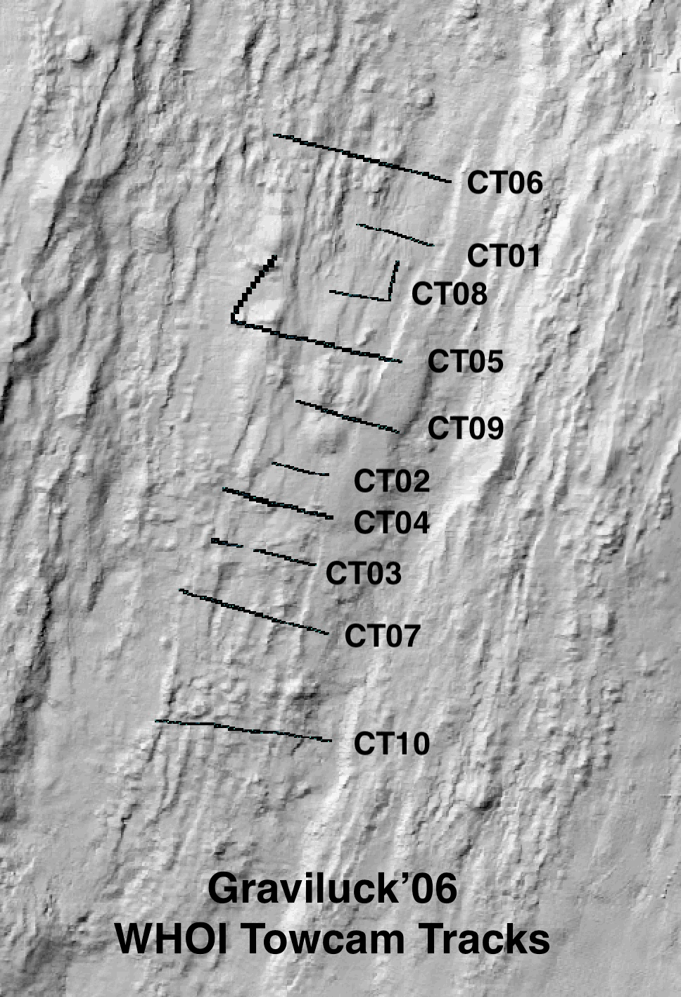
Colour seafloor photomosaics along towed camera tracks crossing the axis of the Lucky Strike ridge segment (Mid Altantic Ridge). Images were acquired with the WHOI TowCam system (https://www.whoi.edu/what-we-do/explore/underwater-vehicles/towed-vehicles/towcam/), during the Graviluck 2016 cruise. Images are process for colour and illumination correction. Images are placed and photomosaiced based on USBL navigation of the TowCam, altitude, and orientation. The datasets include geotiffs for each of the tracks. To be cited: cited: Gini et al. (submitted); Escartin et al. (2008; 2014).
-
Pialassa Baiona is a temperate coastal lagoon connected with the Northwestern Adriatic Sea (44° 280 N and 44°310 E). Sediment cores and surface sediments were collected in two habitats within Pialassa Baiona: a) a salt marsh habitat characterized by the presence of saltmarsh vegetation, and b) a human impacted habitat close to anthropogenic source inputs. Cores were sampled by inserting one cylindrical Plexiglas hand corer (5-cm diameter, 50 cm long) into the sediment to a depth of 20-25 cm, and surface sediment samples (0–5 cm) were collected with a stainless-steel grab sampler. The cores were extruded in the field, sectioned into 1‐2 cm intervals, and analyzed for total organic carbon (OC), total nitrogen (TN), carbon isotope ratio (δ13C) and dry bulk density (upper 20 – 25 cm) and analyzed for organic carbon (OC), total nitrogen (TN), carbon isotope ratio (δ13C) and dry bulk density. Organic carbon (OC), total nitrogen (TN), and carbon isotopes (δ13C = [(13C/12C)sample/(13C/12C)standard − 1] × 1,000) were measured in sediment cores and surface sediments using a using a FINNIGAN Delta Plus XP mass spectrometer directly coupled to Thermo Fisher FLASH 2000 CHNS Elemental Analyzer. OC and TN content was expressed as the weight percentage of dried sediment, and carbon isotope results were reported in the standard delta notation with respect to the Vienna Pee Dee Belemnite. A ‘three-end member’ mixing model was used to estimate the relative contribution of the different organic matter (OM) sources: marine phytoplankton (FM), riverine-estuarine phytoplankton (FRE), and C3 saltmarsh plant material (FSM): δ13Csample = δ13CM x FM + δ13CFE x FFE + δ13CSM x FSM C/Nsample = C/NM x FM + C/NFE x FFE + C/NSM x FSM 1 = FM + FRE + FSM where FM, FRE and FSM are the relative contributions of marine phytoplankton, riverine-estuarine phytoplankton, and saltmarsh plant material, respectively. δ13CM (-18.97‰) and C/NM (4.95), and δ13CRE (-30.70‰,) and C/NRE (6.63) represent the end member POC signature recorded during distinct marine and estuarine phytoplankton blooms in the coastal lagoon (Guerra et al., 2013).The C3 saltmarsh plant end-member was selected on the basis of typical δ13CSM (-20.2‰) and C/NSM (15.35) values for Juncus spp. (Gebrehiwet et al., 2008; Hughes and Sherr, 1983; J. I. Kelleway et al., 2017; Kemp et al., 2012, 2010; Lamb et al., 2006). References Gebrehiwet, T., Koretsky, C.M., Krishnamurthy, R. V., 2008. Influence of Spartina and Juncus on saltmarsh sediments. III. Organic geochemistry. Chem. Geol. 255, 114–119. https://doi.org/10.1016/j.chemgeo.2008.06.015 Guerra, R., Pistocchi, R., Vanucci, S., 2013. Dynamics and sources of organic carbon in suspended particulate matter and sediments in Pialassa Baiona lagoon (NW Adriatic Sea, Italy). Estuar. Coast. Shelf Sci. 135, 24–32. https://doi.org/10.1016/j.ecss.2013.06.022 Kelleway, J.I., Saintilan, N., Macreadie, P.I., Baldock, J.A., Ralph, P.J., 2017. Sediment and carbon deposition vary among vegetation assemblages in a coastal salt marsh. Biogeosciences 14, 3763–3779. https://doi.org/10.5194/bg-14-3763-2017 Kemp, A.C., Vane, C.H., Horton, B.P., Culver, S.J., 2010. Stable carbon isotopes as potential sea-level indicators in salt marshes, North Carolina, USA. Holocene 20, 623–636. https://doi.org/10.1177/0959683609354302 Kemp, A.C., Vane, C.H., Horton, B.P., Engelhart, S.E., Nikitina, D., 2012. Application of stable carbon isotopes for reconstructing salt-marsh floral zones and relative sea level, New Jersey, USA. J. Quat. Sci. 27, 404–414. https://doi.org/10.1002/jqs.1561
-
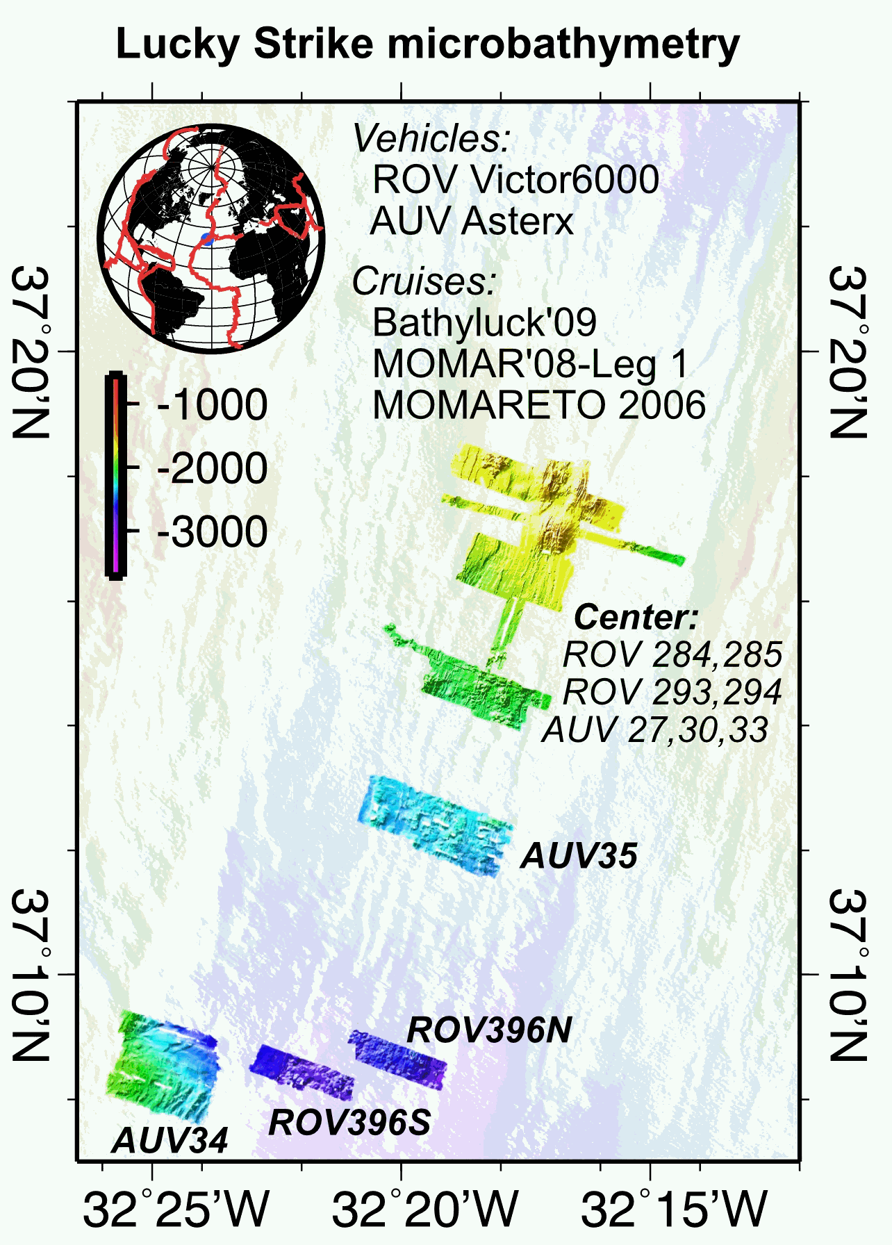
Multibeam near-bottom bathymetry from the Lucky Strike ridge segment along the Mid-Atlantic Ridge. The bathymetry data were acquired during AUV Asterx and ROV Victor6000 surveys during three different cruises (MOMARETO 2006, MOMAR'08-Leg1, & BATHYLUCK'09). The dataset includes a central grid (LuckyStrike_microbathymetry_Centre) that combines data from several AUV and ROV dives, and where original bathymetry grids for each dive have been manually shifted and combined into a single grid, using other datasets (shipboard bathymetry, acoustic sonar data from the Lustre'96 data) for geographical reference. The rest of the grids are from individual ROV or AUV dives. All grids are provided in NETCDF GMT .grd format, and with two associated GEOTIFFS with both the bathymetry DEM and the hillside (illumination) file. All grids are given in WGS84 (WGS 84 - WGS84 - EPSG:4326).
-
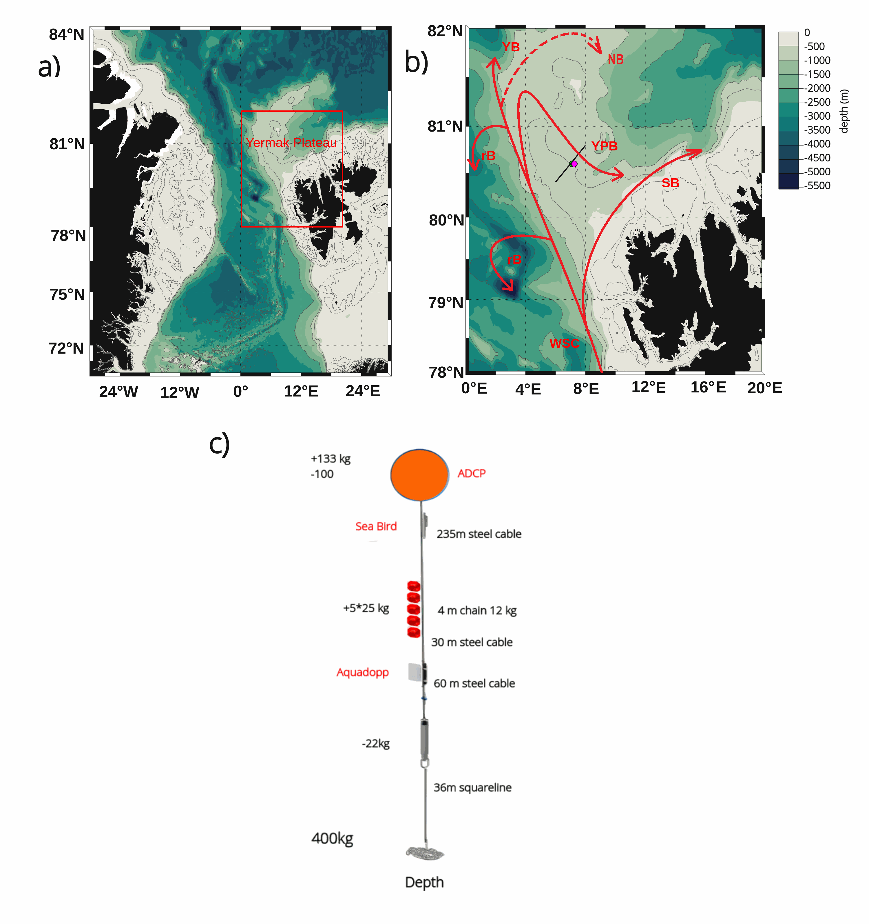
The mooring was deployed on 15 September 2017 from Norwegian Research Vessel Lance at 80.6°N and 7.26°E (depth of 730 m) in the Yermak Pass over the Yermak Plateau north of Svalbard. It comprised 3 instruments: an upward-looking RDI 75kHz, a Long Ranger Acoustic Doppler Current Profiler (ADCP) at 340 m with 16 m vertical resolution (25 bins of 16 m each) and a 2-hour sampling time; a Seabird SBE37 measuring temperature, salinity and pressure at 348 m with 10-minute sampling time; and an Aquadopp current meter at 645 m with a 2-hour sampling time. The mooring was retrieved on the 19 July 2020 by Norwegian Icebreaker K.V. Svalbard. The present dataset features: (i) the ADCP 50-hour smoothed daily velocities, conservative temperature and pressure time series interpolated every 10 meters within the 20-330m layer, (ii) the Aquadopp 50-hour smoothed daily velocities and pressure time series at 645 m; and (iii) the SBE37 50-hour smoothed daily conservative temperature, absolute salinity and pressure time series at 348 m.