 Metadata catalogue
Added-value products
Type of resources
Available actions
Topics
INSPIRE themes
Keywords
Contact for the resource
Provided by
Representation types
Update frequencies
status
Scale
-

The Ocean Heat Content ("OHC") is estimated from the measurement of the thermal expansion of the ocean based on differences between the total sea-level content derived from altimetry measurements and the mass content derived from gravimetry data, noted “altimetry-gravimetry”. The Earth Energy Imbalance ("EEI") indicator is derived from the temporal variations of the ocean heat content, i.e. by calculating its derivative (called the ocean heat uptake). A single NetCDF file provides all variables, including all data used to calculate the Ocean Heat Content and the Earth Energy Imbalance indicators, delivered transparently and allowing users to reconstruct their own Ocean Heat Content or Earth Energy Imbalance indicators. Users will therefore be able to find, among other things : - the regional map of the Ocean Heat Content trends (3°x3°) (see image associated with this metadata sheet) - global ocean heat content time series (representative of the globe within the extent of data availability) - earth energy imbalance time series (from global OHC filtered-out from signals lower than 3 years)
-
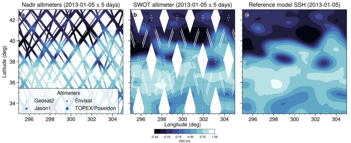
This simulated products "2020A_SSH_MAPPING_NATL60" (SWOT BOOST Data Challenge) are model-based Sea Surface Height (SSH) products and contain Sea Surface Height data simulated on 1) several along-track altimeter orbits (Jason1, Envisat, Geosat2, Topex/Poseidon interleaved and SWOT-nadir orbits - which is not currently in orbit) and 2) the large-swath of SWOT (not currently in orbit). These SSH data are interpolated onto the orbits thanks to the SWOTSimulator package from a realistic high resolution ocean simulation.
-
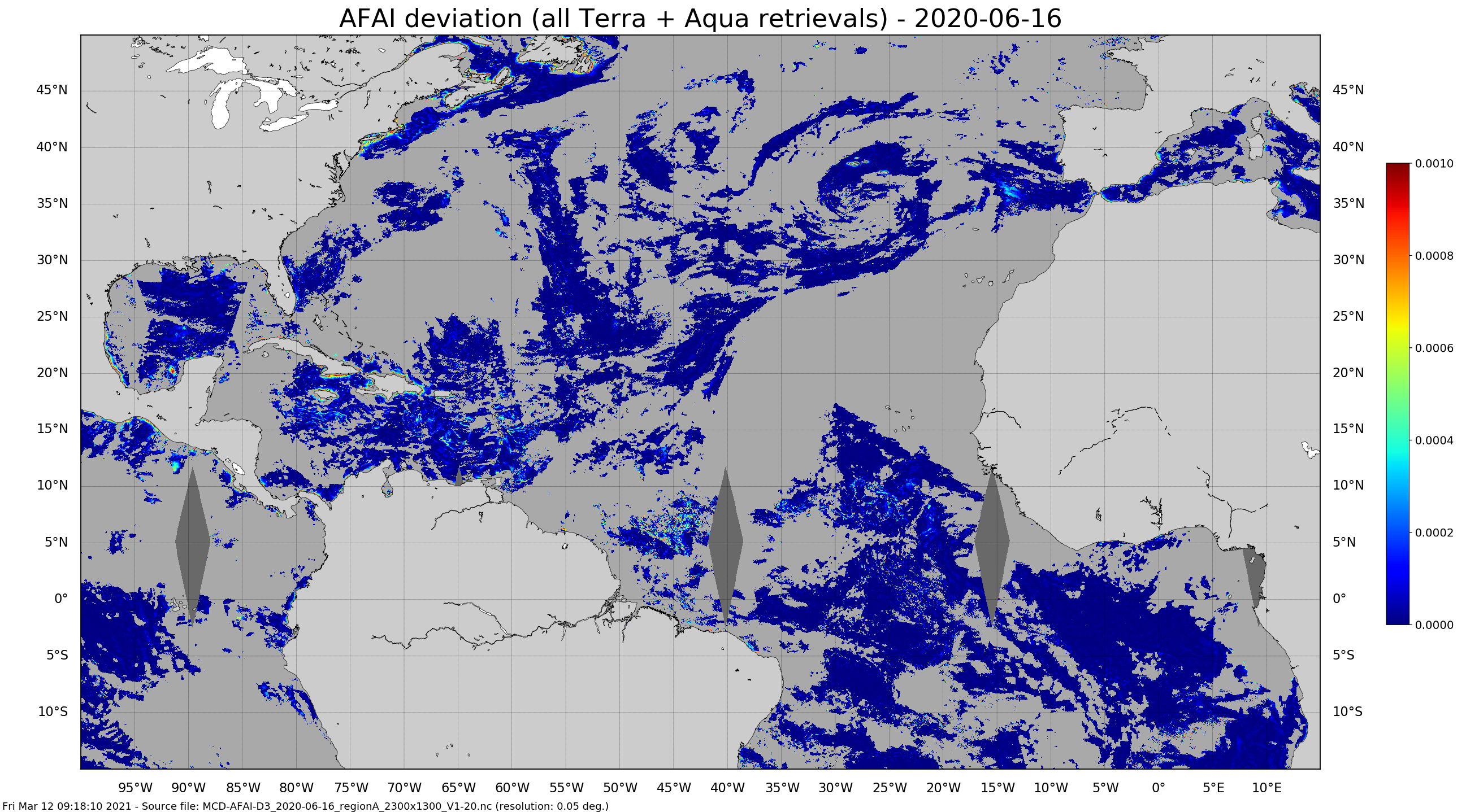
Daily gridded Sargassum area coverage derived from MODIS Terra and Aqua observations over the Atlantic, produced with the AFAI (Alternative Floating Algae Index)-based SAREDA (SArgassum Evolving Distribution in the Atlantic) algorithm.
-
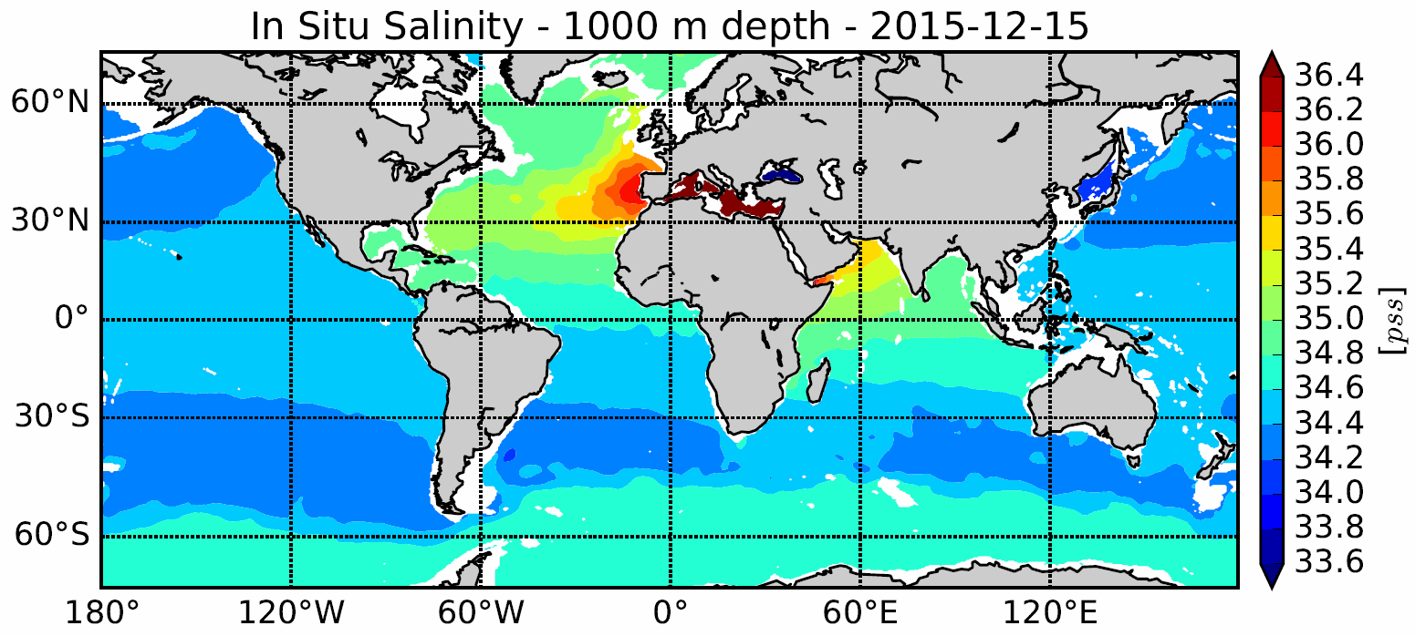
The In Situ Analysis System (ISAS) was developed to produce gridded fields of temperature and salinity that preserve as much as possible the time and space sampling capabilities of the Argo network of profiling floats. Since the first global re-analysis performed in 2009, the system has been extended to accommodate all types of vertical profile as well as time series. ISAS gridded fields are entirely based on in-situ measurements. The system aims at monitoring the time evolution of ocean properties for climatological studies and allowing easy computation of climate indices. A careful delayed mode processing of the 2002-2015 dataset has been carried out using version 7 of ISAS and updating the statistics to produce the ISAS-15 analysis.
-
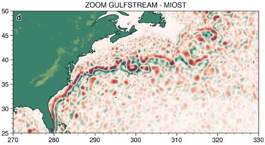
The MIOST (Multiscale Interpolation Ocean Science Topography) experimental altimeter product provides grids at delayed-time, at global scale, 1/10° spatial resolution, the sea surface height (MSLA and MADT) as well as the geostrophic currents, resulting from specific processing. Use for regional studies, ocean variability (mesoscale circulation,...).
-
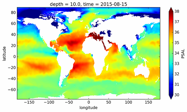
The In Situ Analysis System (ISAS) was developed to produce gridded fields of temperature and salinity that preserve as much as possible the time and space sampling capabilities of the Argo network of profiling floats. The ISAS-SSS configuration provide Sea Surface Salinity gridded fields from in-situ measurements including Argo, Moorings, Marine Mammals, GOSUD Thermosalinometer SSS measurements from delayed mode SNO-SSS merchant ships (http://www.legos.obs-mip.fr/observations/sss), French research vessels (http://doi.org/10.17882/39475) and sails (http://doi.org/10.17882/39476). A careful delayed mode processing of the 2002-2015 dataset has been carried out using version 7 of ISAS and updating the statistics to produce the ISAS-15 analysis. The ISAS-SSS fields appears as highly valuable for the "calibration and validation" of the new satellite observations delivered by SMOS, Aquarius and SMAP.
-
Multimission altimeter products "Experimental" with a finer resolution in preparation to the SWOT Era with sea surface heights computed with respect to a twenty-year mean and Geostrophic velocities, resulting from specific processes, available in delayed time. Use: regional studies, ocean variability (mesoscale circulation,...),