 Metadata catalogue
/Remote sensing
Type of resources
Available actions
Topics
INSPIRE themes
Keywords
Contact for the resource
Provided by
Formats
Representation types
Update frequencies
status
Resolution
-
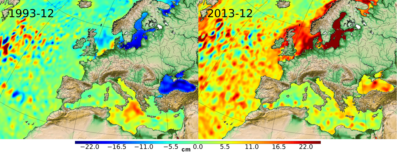
Ssalto/Duacs multimission gridded sea surface heights products. From January 1993 to the last extension of the Delayed-time products, the long delayed-time dataset allows to compute statistical means of Maps of Sea Level Anomalies (MSLA) over different periods of time. Computed with respect to a twenty-year mean profile [1993-2012], and including the seasonal variability (no annual cycle is removed).
-

Monomission Sentinel-3A altimetry product, LR-RMC mode (Low-Resolution with Range Migration Correction) with along-track level-2 estimations at 20Hz rate in LR-RMC mode. LR-RMC associated waveforms are also included, as well with the geophysical corrections applied to the altimeter range (SGDR files).
-
Significant Wave Height (SWH) monomission along-track altimeter satellite product available for Sentinel-3A and Sentinel-3B missions in Near-Real-Time. SWH values are computed from the High Resolution Mode, also known as Synthetic Aperture Radar mode (SAR) and are calibrated relative to buoys. A validity flag and the applied correction are also provided. Since April 2021, a new variable is included in the files : wind speed, computed by Gourrion (2002) algorithm using Collard (2005) table with PLRM sigma0 and SWH. Moreover, the values are cross-calibrated with Jason-3 standard F wind speed.
-
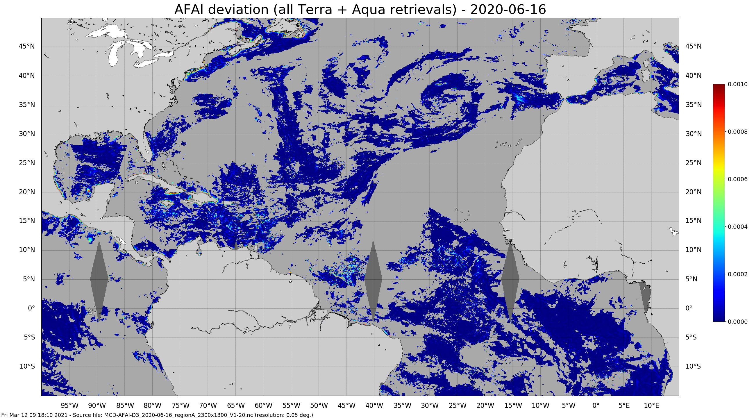
Daily gridded Sargassum area coverage derived from MODIS Terra and Aqua observations over the Atlantic, produced with the AFAI (Alternative Floating Algae Index)-based SAREDA (SArgassum Evolving Distribution in the Atlantic) algorithm.
-
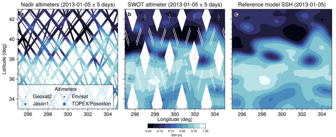
This simulated products "2020A_SSH_MAPPING_NATL60" (SWOT BOOST Data Challenge) are model-based Sea Surface Height (SSH) products and contain Sea Surface Height data simulated on 1) several along-track altimeter orbits (Jason1, Envisat, Geosat2, Topex/Poseidon interleaved and SWOT-nadir orbits - which is not currently in orbit) and 2) the large-swath of SWOT (not currently in orbit). These SSH data are interpolated onto the orbits thanks to the SWOTSimulator package from a realistic high resolution ocean simulation.
-
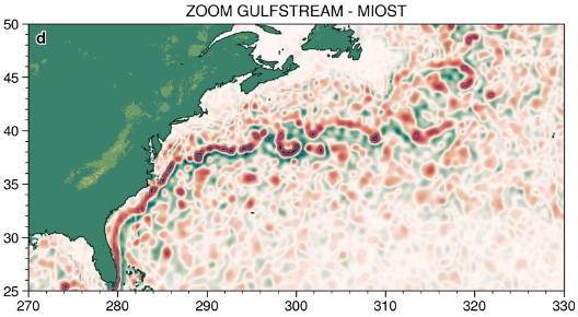
The MIOST (Multiscale Interpolation Ocean Science Topography) experimental altimeter product provides grids at delayed-time, at global scale, 1/10° spatial resolution, the sea surface height (MSLA and MADT) as well as the geostrophic currents, resulting from specific processing. Use for regional studies, ocean variability (mesoscale circulation,...).
-

This L4 SST product is produced at ultra-high resolution (UHR) on a 0.02 x 0.02 degree grid (approximately 2 x 2 km) for the Tropical Atlantic area, every 24 hours. Optimal interpolation (OI) techniques are used to combine coincident swath measures of SST from different types of sensor and to fill gaps where no observations are available. Whereas swath data essentially represent the skin or sub-skin SST, the L4 SST product is defined to represent the SST foundation (SSTfnd). SSTfnd is defined within GHRSST-PP as the temperature at the base of the diurnal thermocline. It is so named because it represents the foundation temperature on which the diurnal thermocline develops during the day. SSTfnd changes only gradually along with the upper layer of the ocean, and by definition it is independent of skin SST fluctuations due to wind- and radiation-dependent diurnal stratification or skin layer response. It is therefore updated at intervals of 24 hrs. SSTfnd corresponds to the temperature of the upper mixed layer which is the part of the ocean represented by the top-most layer of grid cells in most numerical ocean models. It is never observed directly by satellites, but it comes closest to being detected by a microwave radiometer which penetrates the skin, at dawn when the previous day's diurnal stratification can be assumed to have decayed and SSTsubskin, SSTdepth and SSTfnd are equal.
-
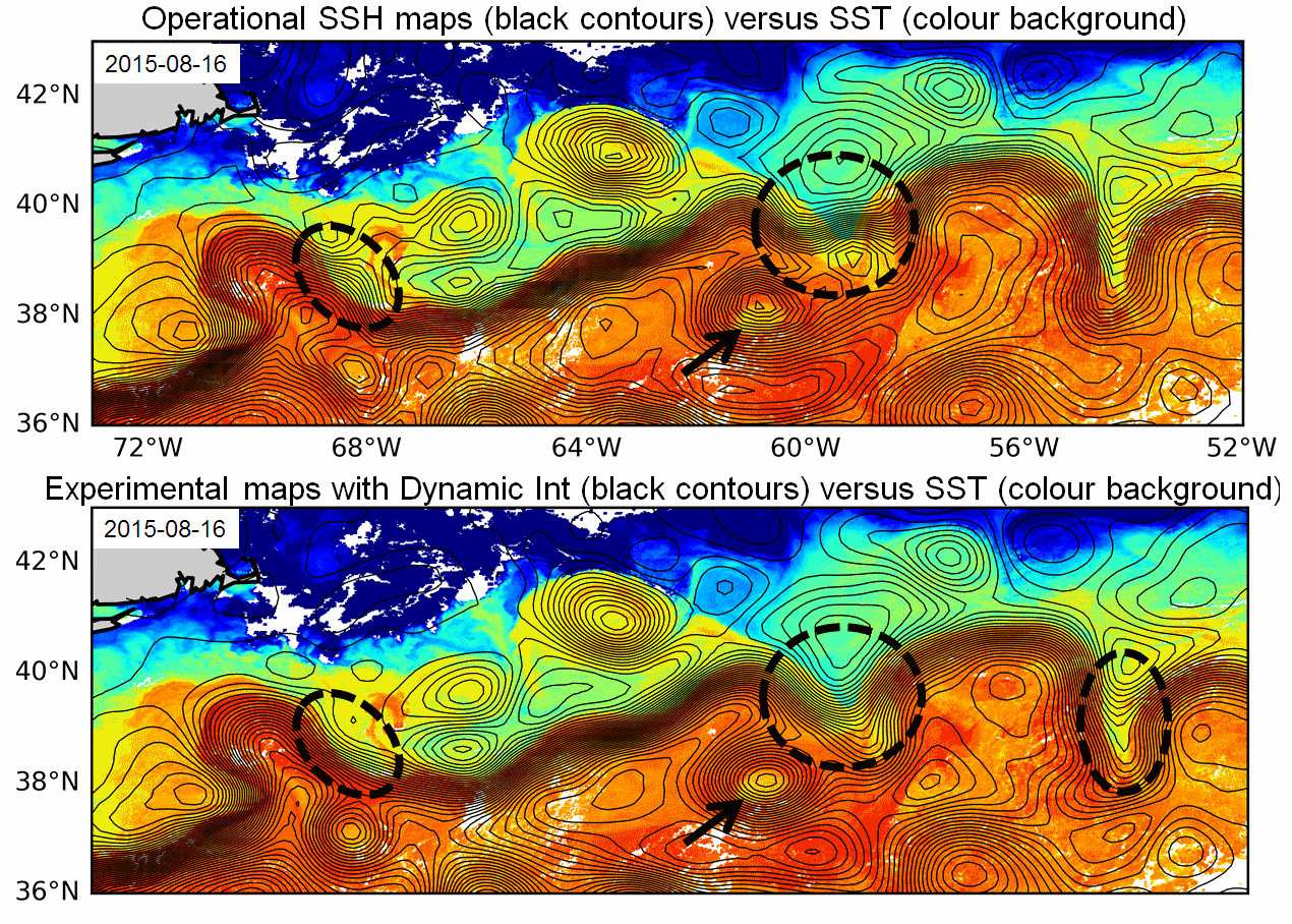
Multimission altimeter products "Experimental" with a finer resolution in preparation to the SWOT Era with sea surface heights computed with respect to a twenty-year mean and Geostrophic velocities, resulting from specific processes, available in delayed time. Use: regional studies, ocean variability (mesoscale circulation,...),
-
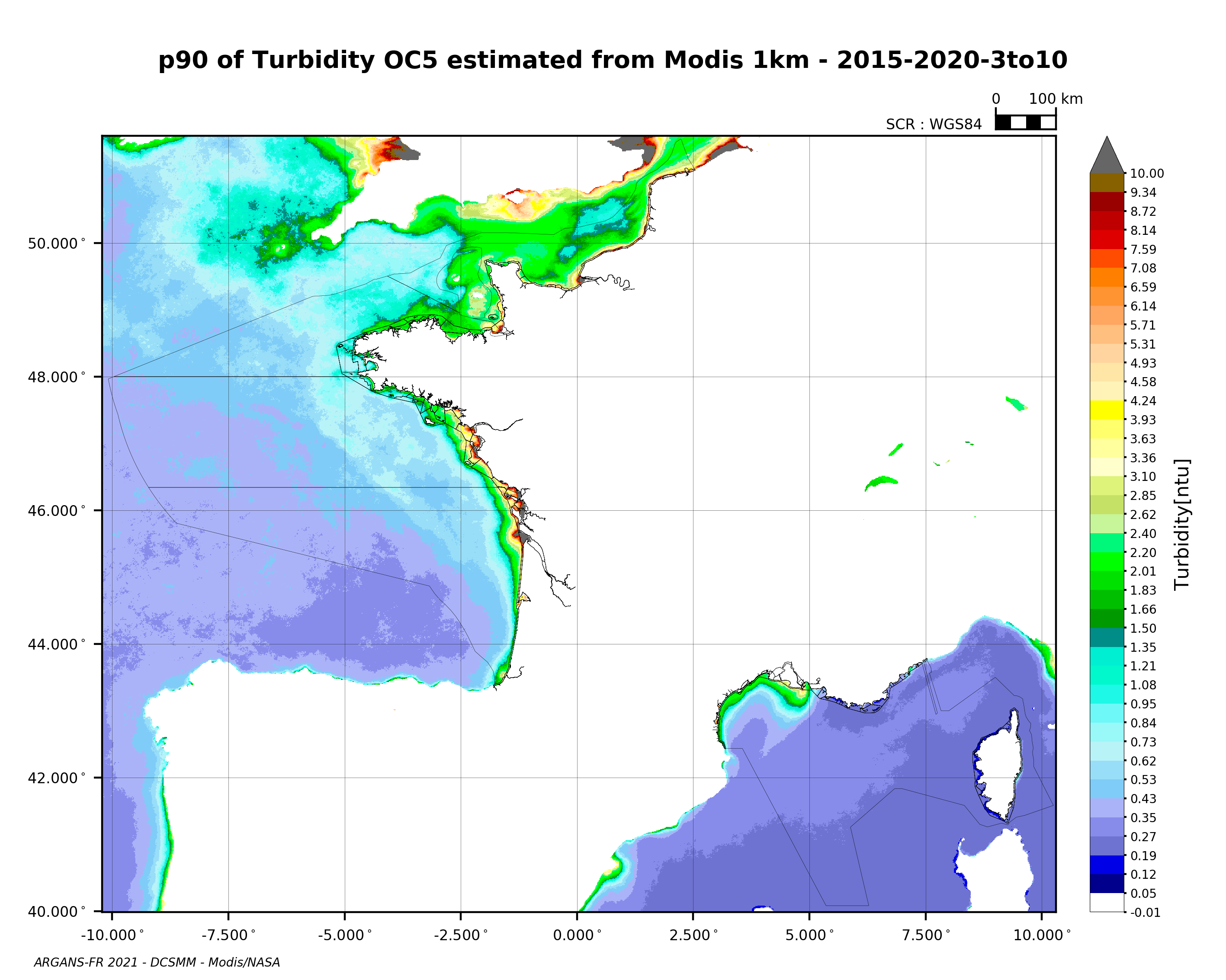
90th percentile of turbidity calculated during the productive period of the WFD (March-October) from 2015 to 2020, from the MODIS algorithm processed by OC5 IFREMER/ARGANS (Gohin et al 2002, Gohin 2011).
-
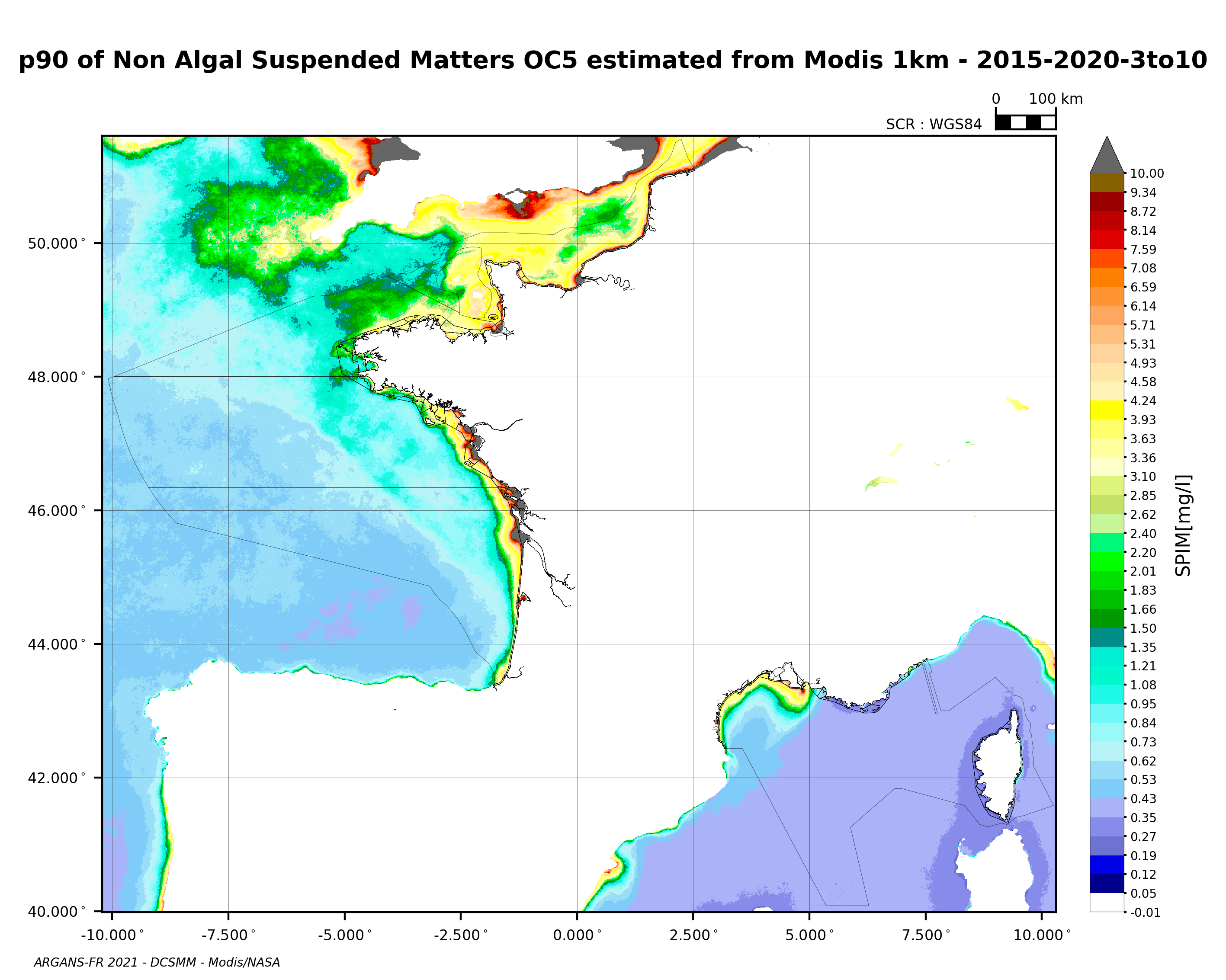
90th percentile of non-algal suspended matter calculated during the productive period of the WFD (March-October) from 2015 to 2020, from the MODIS algorithm processed by OC5 IFREMER/ARGANS (Gohin et al 2002, Gohin 2011).