 Metadata catalogue
/Physical Oceanography/Currents
Type of resources
Available actions
Topics
INSPIRE themes
Keywords
Contact for the resource
Provided by
Formats
Representation types
status
-

Mean subthermocline and intermediate zonal currents meridional sections are produced at several longitudes across the Tropical Pacific, from 18°S to 18°N and 0 to 2000m depth. They are based on a compilation of shipboard ADCP measurements, and absolute geostrophic velocities constructed from a high-resolution 0–2000-m Argo climatology referenced to a 1000-m velocity field derived from Argo float drifts. Description 1) SADCP data obtained from ships transiting in the low-latitude tropical Pacific, during 1999–2015 (see Cravatte et al., 2017, 190 cruises) are compiled. Most of the data (128 cruises) were provided by the Joint Archive for Shipboard ADCP (JASADCP) at the University of Hawaii, with a large fraction from the NOAA ship Ka’imimoana, servicing the TAO array of moored buoys. All data retrieved from the JASADCP center were from their ‘‘standard subset’’ containing hourly averages interpolated to a 10-m vertical grid. For the other datasets, SADCP data were provided as 5- to 15-min temporal averages with 5- to 24-m vertical resolution. They were then averaged and interpolated to the 1-h, 10-m vertical grid. The complete dataset was mapped on a 0.25° latitude by 1° longitude grid using a simple Gaussian weighting function with 0.25° latitude and 3° longitude decorrelation scales, independent of the timing of the measurements, with windows of 0.5° of latitude and 6° of longitude. 2) The mean Argo temperature and salinity gridded climatology with a 1/6° resolution (Roemmich and Gilson 2009 was used to compute dynamic height anomalies. Derived zonal geostrophic shear both on and off the equator were computed following the method presented by Picaut and Tournier (1991) using a 1000-m reference level. The 1000-m Argo float drift then provided the constant of integration for vertically integrating the geostrophic shear to obtain a field of mean absolute geostrophic velocity.
-
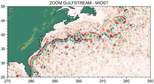
The MIOST (Multiscale Interpolation Ocean Science Topography) experimental altimeter product provides grids at delayed-time, at global scale, 1/10° spatial resolution, the sea surface height (MSLA and MADT) as well as the geostrophic currents, resulting from specific processing. Use for regional studies, ocean variability (mesoscale circulation,...).
-
Multimission altimeter products "Experimental" with a finer resolution in preparation to the SWOT Era with sea surface heights computed with respect to a twenty-year mean and Geostrophic velocities, resulting from specific processes, available in delayed time. Use: regional studies, ocean variability (mesoscale circulation,...),