 Metadata catalogue
/Observational data/in-situ
Type of resources
Available actions
Topics
Keywords
Contact for the resource
Provided by
Years
Formats
-
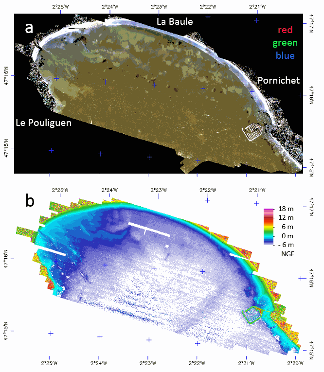
The LiDAR used is the Titan DW 600 from Teledyne Optech of the “Platform topo-bathymétrique aéroportée Nantes-Rennes”. Both 532-nm and 1064-nm LiDAR swath were acquired 6th and 7th of October 2017, at 400 m above ground with a FOV of 28° giving strip image width of 199.5 m with a nominal footprint of 0.49 m along-track and 0.29 m cross-track. A mirror compensation and a sidelap of 30% was used to prevent empty space between strips. The effective incident angle range was from 4 to 20°. The aircraft speed being 201.7 km/h the down track footprint rise up to 0.98 m on sideway what justify a final spatial resolution of 1 m. The laser pulse frequency was set to 50 kHz (100 kHz locally) giving an overall mean point density of 3.52 points/m². The full-waveform (FWF) was recorded only in 532-nm with a maximum length of 60 m, at 1 GHz frequency, resulting in a vertical resolution of 0.15 m. The Optech LiDAR Mapping Suite (LMS) combines a Global Positioning System (GPS) and Inertial Measurement Unit (IMU) to provide a georeferenced point cloud and associated FWF with strip optimization. To compute the complete point cloud, LMS uses an analogous approach to photogrammetric block adjustment. On overlap areas between each flight line, planes (typically roofs in land) are extracted and used in a least squares adjustment model provided by LMS. The trajectory accuracy provided by GEOFIT Company was better than 0.15 m in planimetry and 0.08 m on elevation. The set of data is stored in a zip file composed of the following image files associated with ENVI headers which are text files describing the image format. - LaBaule_2017106-7-orthophoto: contain the mosaic of RGB image acquired with the camera associated to the LiDAR. - LaBaule_2017106-7_536nm_raytracing-incident_angles_2m: contains the effective incident angle of each pixel retained in the mosaic with a pixel FOV of 0.3° and with a tilling of image strips in the top of each other from the North to the South. - LaBaule_2017106-7_1064nm_raytracing_discrete_echo_ranges_2m: contains the elevation of the water surface of each pixel. - LaBaule_2017106-7_536nm_raytracing_FWF_2m: contains the row FWF projected on the image plane at 0 m NGF with an offset of 30 m for easy spectral processing of the FWF (true range are stored in band names). - LaBaule_2017106-7_536nm_raytracing_FWF_2m_intensity_stats: contains the basic statistics of the FWF intensities. - LaBaule_2017106-7_536nm_raytracing_FWF_2m_range_stats: contains the min, max and thickness of the FWF ranges. - LaBaule_2017106-7_536nm_raytracing_FWF_2m_row_results: contains the row results of water surface and method 1 (dddNCFWF echoes) and method 2 (NCFWFT-1 bottoms) bathymetries as defined in https://doi.org/10.3390/rs11020117. - LaBaule_2017106-7_536nm_raytracing_FWF_4m_final_bathymetry: contains the final (cleaned NCFWFT-1 bottoms) bathymetry. The same data were acquired the 11th of August 2018 during a low tide with the same settings without RGB camera but with a new FWF recorder giving a lot less noisy signal allowing a constant spatial resolution of 1 m. The set of data is stored in a zip file composed of the following image files associated with ENVI headers which are text files describing the image format. - LaBaule_20180811_536nm_raytracing-incident_angles_1m: contains now 3 channels for the effective incident angle, the strip number and the GPS time. - LaBaule_20180811_1064nm_raytracing_discrete_echo_ranges_1m: contains the elevation of the water surface and all echoes above it in each pixel. - LaBaule_20180811_536nm_raytracing_FWF_1m: contains the row FWF projected on the image plane at 0 m NGF with an offset of 30 m for easy spectral processing of the FWF (true range are stored in band names). - LaBaule_20180811_536nm_raytracing_FWF_1m_intensity_stats: contains the basic statistics of the FWF intensities. - LaBaule_20180811_536nm_raytracing_FWF_1m_range_stats: contains the min, max and thickness of the FWF ranges. - LaBaule_20180811_536nm_raytracing_FWF_1m_row_results: contains the row results of water surface and method 1 (dddNCFWF echoes) and method 2 (NCFWFT-1 bottoms) bathymetries as defined in https://doi.org/10.3390/rs11020117. - LaBaule_20180811_536nm_raytracing_FWF_1m_final_bathymetry: contains the best of dddNCFWF echoes and NCFWFT-1 bottoms simply presented with the application of a 5x5 median filter. -
-
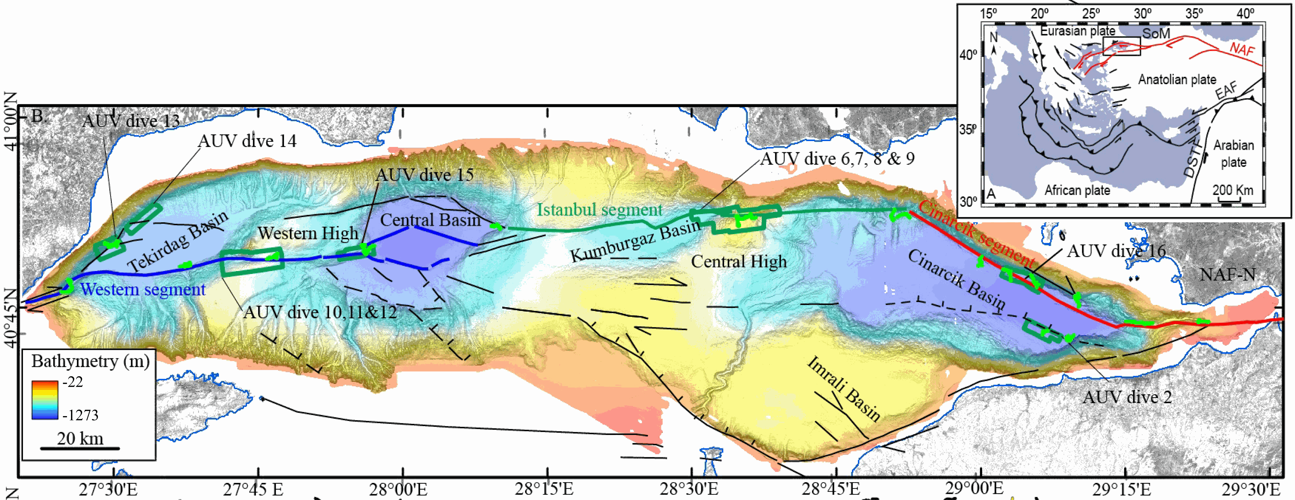
This data set contains processed multibeam sounder data from 12 dives of AsterX AUV performed on active faults scarps of the North Anatolian Fault system in the Sea of Marmara during the Marmesonet cruise (2009). The AUV carried a SIMRAD EM2000 multibeam echosounder, operating at 200 kHz, and surveyed at 50 to 70 m altitude, allowing a swath width of 150-200 m. Digital Elevation Models (DEM, in meters below sealevel) and seafloor backscatter intensity mosaics (relative amplitude in dB) are provided for 7 zones: Tekirdağ Basin W (dive 13), Tekirdağ Basin NW (dive 14), Western High (dives 10, 11 and 12), Western High E (dive 15), Central High (dive 6,7,8 and 9), Çınarcık Basin N (dive 16), Çınarcık Basin S (dive 2) (see figure). The horizontal resolution and grid pixel size of the DEM is 2 m. That of the backscatter intensity image is 1 m. Two versions of the DEM are provided. Version 1 is consistent with the backscatter image. Version 2 was updated applying a Fofonoff correction to the depths and relocating part of the AUV multibeam sounding points to fit EM302 shipborne multibeam maps. Version 2 depths and absolute positions are more accurate (10 m in the WGS-84 reference frame), but Version 1 will give better results if the backscatter image is applied as a texture or shading on the DEM. DEM and Backscatter raster files are provided in GeoTIFF format (readable with ArcGis 10.3 and QGIS 3) and use projected cartesian coordinates. They were converted from CARAIBES (Ifremer bathymetry and imagery processing software) output raster files with QGIS using GDAL translator. The Coordinate Reference System is a world Mercator projection based on WGS-84 datum, using meter units and a standard parallel at N40° latitude (latitude of preserved scale) {proj4: +proj=merc +lon_0=0 +lat_ts=+40 +x_0=0 +y_0=0 +datum=WGS84 +units=m +no_defs}. For GIS skeptics, one possible way to use these grids with Generic Mapping Tools is to perform a reverse projection back to geographic coordinates. Assuming the default PROJ_ELLIPSOID is properly set to WGS-84, the reverse projection can be applied (using gmt version 5) with the following command line: gmt grdproject AUV_XXX.tif=gd -GAUV_XXX.grd -Jm0/40/1:1 -F -C -I -V
-
During the SARDINIA experiment, CHIRP profiles, bathymetry data, three coincident MCS reflection and wide-angle seismic profiles, and one single MCS reflection profile were collected on the West Sardinia margin. The MCS reflection data was acquired using a 4.5 km 360-trace digital streamer and a tuned airgun array of 8260 cubic inches, which was towed at a depth of 18-28 m. A total of 48 ocean bottom seismometers/hydrophones (OBS/OBH) from Ifremer, University of Brest, and Geomar Kiel were deployed on the West Sardinia margin, spaced every 7 nmi (~13 km). In five locations, three OBS were deployed at the same place to ensure the collection of data. The airgun array consists of 16 airguns ranging from 100 cubic inch G-guns to 16 L Bolt airguns, with main frequencies centered around 10-15 Hz. The airguns were tuned to the first bubble, to enhance low frequencies and ensure deep penetration. The shot interval was 60 s at an average speed of 5 knots, which translates to a trace spacing of about 140-150 m. The sample rate was 8 ms for the micrOBS, 5 ms for the Geomar, and 4 ms for the OldOBS. A total of 3573 shots (profile GH: 1130, profile G2H2: 1214) were fired by the air gun array. Profiles GH and G2H2, which are 160 and 200 km long transects, respectively cross the West Sardinia margin from the continental shelf to the “atypical” oceanic crust. Twenty-one ocean bottom seismometers (OBS) were deployed on the G2H2 profile, whereas sixteen were deployed on the GH profile. Additionally, the shots on this profile were recorded by eight land seismic stations (OSIRIS stations from the University of Brest and Geosciences Azur) that extended the marine profile ~150 km onshore. For the two profiles only 33 instruments were used in the wide-angle modeling, since four instruments (OBSS06, 18a, 30a, and 30c) did not record properly. We propose here the velocity models (v.in files) of the 2 main profiles located on the West sardinian margin, Profile K7L2, located on the shelf and parallel to the margin, is not presented since most of the deep arrivals are masked by the presence of sea-bottom multiples, preventing an accurate wide-angle model.
-

During the SARDINIA experiment, three coincident MCS reflection and wide-angle seismic profiles, sub-bottom high resolution (CHIRP) profiles, and bathymetry data were collected on the Gulf of Lion margin. The seismic reflection data were acquired using a 4.5 km, 360 trace digital streamer and a tuned airgun array of 8260 in3, towed at a depth of 18-28 m. A total of 57 ocean bottom seismometer/ hydrophones (OBS/OBH) from Ifremer, University of Brest, and Geomar Kiel were deployed in the Gulf of Lion, spaced every 7 Nm (~13 km). The airgun array consists of 16 airguns ranging from 100 in3 G-guns to 16 L Bolt airguns, with main frequencies centered around 10-15 Hz. The airguns were tuned to the first bubble to enhance low frequencies and ensure a good penetration. The shot interval was 60 s at an average speed of 5 knots, which translates to a trace spacing of about 140-150 m. The sample rate was 8 ms for the micrOBS, 5 ms for the Geomar’s OBS and 4 ms for the OldOBS. A total of 6160 shots (profile AB: 3032, profile CD: 1730, profile EF: 1398) were fired by the air gun array. Profile AB crosses the Gulf of Lion’s margin, parallel to the ECORS profile, from the continental shelf to Domain III. Twenty-five ocean bottom seismometers (OBS) were deployed on this profile, of 467 km in length. Twenty-two instruments were used in the wide-angle modelling, since three instruments (OBS 45, 49 and 52) did not properly record. The shots on this profile were additionally recorded by 9 land seismic stations (OSIRIS stations from the University of Brest and Geosciences Azur) that have extended the marine profile ~120 km onshore. Profiles CD and EF are 250 and 210 km long transects parallel to the margin. Profile CD was acquired using 19 OBS of which 18 yielded usable data. Profile EF was acquired using 15 OBS of which 12 yielded usable data. These two profiles cross the profile AB, respectivelyat OBS 26 and OBS 8.
-
The present database is composed of a polygon shape file (.shp) dedicated to GIS applications. This seafloor surface represents the area within which (sub-)outcropping methane derived authigenic carbonates were identified based on ship-borne multibeam bathymetry and seafloor backscatter data; as displayed in Figs. 4 and S1a of Dupré et al. 2020 (Dupré S, Loubrieu B, Pierre C, Scalabrin C, Guérin C, Ehrhold A, Ogor A, Gautier E, Ruffine L, Biville R, Saout J, Breton C, Floodpage J, Lescanne M (2020) The Aquitaine Shelf Edge (Bay of Biscay): A Primary Outlet for Microbial Methane Release. Geophysical Research Letters 47 (7):e2019GL084561. doi:10.1029/2019gl084561). The presence of (sub-)outcropping methane-derived authigenic carbonates at the seafloor was confirmed by remotely-operated-vehicle dives during the GAZCOGNE2 marine expedition. The acoustic data were acquired in 2013 on board the R/V Le Suroît during the GAZCOGNE1 expedition with two ship-borne multibeam echosounders, the Kongsberg EM302 and EM2040, with transmission frequency of 30 and 200 kHz, respectively. Details on multibeam data acquisition, processing and interpretation of sub-outcropping methane-derived authigenic carbonate structures are presented in Dupré et al 2020 (including a Supporting Information section). Cited from Dupré et al 2020: “The carbonates are exclusively located along the shelf edge with the majority (98%) between 140 and 220 m water depths. The (sub-)outcropping carbonates are spread over a 375 km2 area that extends over a distance of 80 km between the Cap Ferret and Capbreton canyons. The western spatial limit of the methane-derived authigenic carbonates coincides with the shelf break.”
-
This dataset was recorded from 15th of April to 31st of July , 2011, by 10 autonomous, short-period (4.5 Hz) OBSs from Ifremer.
-
GraviMob-1 campaign is an underwater gravimetric survey conducted near the southern coast of France in the Mediterranean Sea in March 2016. The AUV Asterx was used to carry the GraviMob system. The operation was performed on board the vessel Europe. The data and processing results of this campaign are supporting the paper "High-resolution gravity measurement on board an Autonomous Underwater Vehicle: Data reduction and accuracy assessment". The dataset thus contains the following elements: 1. The raw data exported from GraviMob 2. The shipborne gravity data provided by SHOM 3. The processing results
-

The data was collected during the survey NOMADS 09 (2009) conducted by the SHOM on the R/V Laplace. The bathymetry of the shelf edge and upper slope of the Moroccan Western Rifan continental Margin offshore the Spartel Headland (South of Gulf of Cadiz)) higtlights a field of NS trending kilometer-scale bathymetric ridges with elevation reaching more than 20m above surrounding seabed.
-
Sea fans (order : Alcyonacea) are the most remarkable and easily identifiable species of the subtidal hard substrate communities (Gili and Ros, 1985). From an ecological point of view, sea fans play an essential role (Gili and Coma, 1998) by increasing the biomass and the diversity of hard substrates (Mitchell et al, 1992; Ballesteros, 2006) via an umbrella species role providing habitat for small epifauna and a refuge for many fish (Ross and Quatrini, 2007). When their density is high enough, they form animal forests (sensu Rossi et al 2017) and become engineering species by modifying the level of turbulence and therefore of sedimentation of propagules in the benthic boundary layer (Chamberlain and Graus, 1975). In the shallow rocky habitats of the Mediterranean, five species of sea fans dominate: the white gorgonian Eunicella singularis (Esper, 1791), the orange gorgonian Leptogorgia sarmentosa (Esper, 1789), the yellow gorgonian Eunicella cavolinii (Koch, 1887), the red gorgonian Paramuricea clavata (Risso, 1826), and the red coral Corallium rubrum (Linnaeus, 1758). Some of these species, characterized by long life span, have been included in the management plans of the Gulf of Lion Marine Protected Areas, with surveys for the monitoring of the demographic structure of E. Singularis (Réserve Naturelle Marine de Cerbère-Banyuls, Aire Marine Protégée Agathoise) and C. rubrum (Réserve Naturelle Marine de Cerbère-Banyuls, Parc Marin de la Côte Bleue). In parallel with these management-related surveys, some scientific studies on the demographic structure and ecology of P. clavata, E. singularis and C. rubrum, with the aim of documenting mass mortality events (Cerrano et al. al., 2000, Garrabou et al., 2001) have been undertaken in the Parc Marin de la Côte Bleue, in the Parc National de Port-Cros, along the Côte Vermeille and Cap de Creus coast and in the Cinque Terre National Park (Garrabou and Harmelin, 2002, Torrents et al., 2005 ; Linares et al. 2008 Linares et al., 2010 ; Santangelo et al., 2011; Gori et al., 2011a ; Gori et al. 2011b; Rossi et al., 2008). The present database gathers two extensive inventory of sea fans populations performed between 2013 and 2015 in the Gulf of Lion and between 2018 and 2019 in the Ligurian Sea. The same protocol was applied to estimate the population density of the five species in 585 stations. The 585 stations were defined a priori on a regular mesh mapping the main hard-bottom substrate units of the Gulf of Lion (Côte Bleue, Plateau des Aresquiers, Plateau du Cap d'Agde, Cap Leucate, Côte Vermeille), and surrounding the ports of Toulon, La Spezia and Bastia (Figure 1). The spacing between stations was varied from 100m to 800 m according to bathymetry steepness. Each station was geo-referenced from the surface and located on the sea bed with a mooring. Counts of individuals of the five species were made by scuba divers trained to species identification in four quadrats (1m x 1m), positionned at 5 m from the mooring along the sea bed, in the four cardinal directions. In total, the sampling required 1500 dives. References Ballesteros E. 2006. Mediterranean coralligenous assemblages: a synthesis of present knowledge Oceanography and Marine Biology: An Annual Review 44, 123-195 Carpine C, Grasshoff M. 1975. Les gorgonaires de la Mediterranee. Bull Inst Oceanogr Monaco 71:1–140 Cerrano, C., Bavestrello G., Bianchi C.N., Cattaneo R. Vietti, S. Bava, C. Morganti, C. Morri, P. Picco, G. Sara S. Schiaparelli S. Siccardi A. & Sponga, F. 2000. A catastrophic mass-mortality episode of gorgonians and other organisms in the Ligurian Sea (Northwestern Mediterranean), summer 1999. Ecology Letters 3: 284–293. Chamberlain J.J. A., Graus, R.R. 1975. Water Flow and Hydromechanical Adaptations of Branched Reef Corals. : Bulletin of Marine Science 25 (1): 112-125 Garrabou J., Perez T., Sartoretto S., Harmelin J.G., 2001. Mass mortality event in red coral Corallium rubrum populations in the Provence region (France, NW Mediterranean). Mar Ecol Prog Ser 217:263–272 Garrabou J., Harmelin G. 2002. A 20-year study on life-history traits of a harvested long-lived temperate coral in the NW Mediterranean: insights into conservation and management needs. J Anim Ecol 71:966–978 Gili, J.M., & Ros, J. 1985. Study and cartography of the benthic communities of the Medes Islands (NE Spain). Marine Ecology 6, 219–238. Gili J.M. and Coma R. 1998. Benthic suspension feeders: their paramount role in littoral marine substrates. TREE 13 (8): 316-321 Gori, A., Rossi, S., Linares, C., Berganzo, E., Orejas, C., Dale, M. & Gili, J.M. 2011a. Size and spatial structure in deep versus shallow populations of the Mediterranean gorgonian Eunicella singularis (Cap de Creus, Northwestern Mediterranean Sea)” Marine Biology, DOI: 10.1007/s00227-011-1686-7 Gori A., Rossi S., Berganzo E., Pretus J.L., Dale M.R.T., Gili J.M. 2011b. Spatial distribution patterns of the gorgonians Eunicella singularis, Paramuricea clavata and Leptogorgia sarmentosa (Cape of Creus, Northwestern Mediterranean Sea). Mar Biol 158:143-158 Linares C, Coma R, Garrabou J, Diaz D, Zabala M. 2008. Size distribution, density and disturbance in two Mediterranean gorgonians: Paramuricea clavata and Eunicella singularis. J Appl Ecol 45:688–699 Linares C., Bianchimani O., Torrents O., Marschal C., Drap P., Garrabou J., 2010. Marine Protected Areas and the conservation of long-lived marine invertebrates : the Mediterranean red coral. Marine Ecology Progress Series 402: 69-79. Mitchell, N. D., Dardeau, M. R., Schroeder,W. W., Benke, A. C. 1992. Secondary production of gorgonian corals in the northern Gulf of Mexico. Mar Ecol. Prog. Ser. 87: 275-281 Ross S., Quattrini A. 2007. The fish fauna associated with deep coral banks off the southeastern United States. Deep Sea Research I (54): 975-1007. Rossi S, Bramanti L, Gori A, Orejas C. 2017. An Overview of the Animal Forests of the World. In book: Marine Animal Forests, pp.1-26. SPRINGER.[DOI: 10.1007/978-3-319-17001-5_1-1] Santangelo G., Bramanti L., Rossi S., Tsounis G., Vielmini I., Lott C., Gili J.M. 2011. Spatial patterns of variation in recruitment and post-recruitment processes of the Mediterranean precious gorgonian coral Corallium rubrum. Journal of Experimental Marine Biology and Ecology. DOI: 10.1016/j.jembe.2011.10.030 Torrents O., Garrabou J., Marshal C., Harmelin J.G., 2005. Age and size at first reproduction in the commercially exploited red coral Corallium rubrum (L.) in the Marseilles area (France, NW Mediterranean). Biol Conserv 121: 391–397 Rossi S., Tsounis G., Orejas C., Padrón T., Gili J.M., Bramanti L., Teixidó N. and Gutt J. 2008. Survey of deep-dwelling red coral (Corallium rubrum ) populations at Cap de Creus (NW Mediterranean). Marine Biology 154 (3): 533-545.
-

This seismic data set was recorded in September 2015 on board the R/V Pourquoi Pas? during the GHASS cruise (IFREMER) on the western Black Sea, offshore Romania. The available profiles (part of the collected data) within this deposit are located on the continental slope, bathymetry between 500 to 1200 meters. The pre-processing of the seismic data included common midpoint binning @6.25 meters, trace and shot edition, source delay correction, and a 35-375 Hz band pass filtering. Detailed Root Mean Square Velocity analyses were performed on semblance panels computed using super gathers every 150 m. Normal Move Out time correction was then applied on the Common Mid Point (CMP) using these velocities prior to stack. Interval velocities were computed using the Dix equation. The velocity model was then interpolated every CMP location, converted to depth and smoothed to perform post-stack depth migration. The depth migrated sections and the depth velocity models have been output to standard SEG-Y rev1 format (https://library.seg.org/pb-assets/technical-standards/seg_y_rev1-1686080991247.pdf) with values written using “big-endian” byte ordering and IEEE floating-point. For a given profile, both SEGY files have the same number of traces and the same bin locations. Velocity unit is in meter.second-1. The depth sampling is set to 0.5 meter for both files. The recording delay is zero for the depth migration SEGY files. The delay is coded in meters and constant for a given depth velocity SEGY file, stored within the Trace Header (bytes 109-110). Trace coordinates are also stored within the Trace Header using WGS84 +DDDMMSS.ss format with a scale factor of -100 (bytes 81-88, which means that the value has to divided by 100) . For more convenient access to the location of the profiles, these coordinates are also stored into ASCII files using decimal degrees.