 Metadata catalogue
/Nord de la Réunion
Type of resources
Available actions
Topics
INSPIRE themes
Keywords
Contact for the resource
Provided by
Years
Representation types
Scale
-
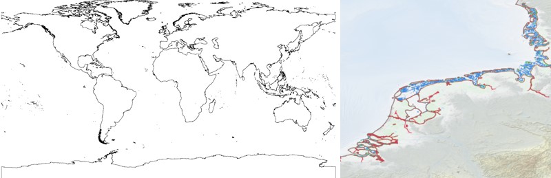
The EMODnet Bathymetry World Coastline is available as a WFS service from EMODnet Bathymetry. The service URL is: https://ows.emodnet-bathymetry.eu/wfs. The layer contains vector lines derived from land polygons available from OpenStreetMap. The original source url is https://osmdata.openstreetmap.de/. Parts of these polygons have been modified for use in EMODnet Bathymetry. In addition to the OSM EMODnet default coastline, three sub-layers are available as part of the EMODnet world coastline service. These sub-layers contain the best-estimate coastlines for Europe determined by Dutch research institute Deltares from satellite data (typically Sentinel-2 and Landsat-8) and in combination with the Global Tide Surge Model (GTSM) processed into digital coastlines for the European seas at LAT (Lowest Astronomical Tide), MSL (Mean-Sea-Level), and MHW (Mean-High-Water). The level of detail is bound to the resolution of the satellite sensor (e.g. 10m for Sentinel-2). The latest 2024 version covers the entire coastline of Europe and now also part of the Caribbean. A detailed paper is available describing the methodology used to determine the three versions of the satellite derived coastline: https://emodnet.ec.europa.eu/sites/emodnet.ec.europa.eu/files/public/EMODnet_Bathymetry_2024-satellite_derived_coastline_report_Deltares_Feb2025.pdf
-

The EMODnet Bathymetry World Coastline is available as a WFS service from EMODnet Bathymetry. The service URL is: https://ows.emodnet-bathymetry.eu/wfs. The layer contains vector lines derived from land polygons available from OpenStreetMap. The original source url is https://osmdata.openstreetmap.de/. Parts of these polygons have been modified for use in EMODnet Bathymetry. In addition to the OSM EMODnet default coastline, three sub-layers are available as part of the EMODnet world coastline service. These sub-layers contain the best-estimate coastlines for Europe determined by Dutch research institute Deltares from satellite data (typically Sentinel-2 and Landsat-8) and in combination with the Global Tide Surge Model (GTSM) processed into digital coastlines for the European seas at LAT (Lowest Astronomical Tide), MSL (Mean-Sea-Level), and MHW (Mean-High-Water). The level of detail is bound to the resolution of the satellite sensor (e.g. 10m for Sentinel-2). The latest December 2022 version covers the entire coastline of Europe and now also part of the Caribbean. A detailed paper is available describing the methodology used to determine the three versions of the satellite derived coastline: https://emodnet.ec.europa.eu/sites/emodnet.ec.europa.eu/files/public/EMODnet-Bathymetry_2022_satellite_derived_coastlines_Deltares-Feb2023.pdf
-
En réponse à la sensibilité des littoraux face aux aléas naturels et anthropiques, le SNO DYNALIT, labellisé par le CNRS INSU en 2014, permet, au travers de ces observations, de quantifier les évolutions du littoral en France métropolitaine et ultra-marine, et de comprendre les processus qui sont à l'origine des changements morphodynamiques littoraux. Il est dédié à la métrologie récurrente et de long terme visant à caractériser le fonctionnement du littoral et gère ainsi l’acquisition, la collecte et la mise en cohérence de données métrologiques de qualité de 35 sites ateliers (côtes sableuses, falaises, embouchures) répartis sur toutes les façades maritimes françaises.